Lisors
| Lisors | ||
|---|---|---|
|
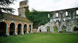
Ruins of Mortemer Abbey | ||
| ||
 Lisors | ||
|
Location within Normandy region  Lisors | ||
| Coordinates: 49°21′11″N 1°28′16″E / 49.353°N 1.471°ECoordinates: 49°21′11″N 1°28′16″E / 49.353°N 1.471°E | ||
| Country | France | |
| Region | Normandy | |
| Department | Eure | |
| Arrondissement | Les Andelys | |
| Canton | Lyons-la-Forêt | |
| Government | ||
| • Mayor (2008–2014) | André Olivier | |
| Area1 | 10.75 km2 (4.15 sq mi) | |
| Population (2008)2 | 361 | |
| • Density | 34/km2 (87/sq mi) | |
| Time zone | CET (UTC+1) | |
| • Summer (DST) | CEST (UTC+2) | |
| INSEE/Postal code | 27370 / 27440 | |
| Elevation |
62–178 m (203–584 ft) (avg. 99 m or 325 ft) | |
|
1 French Land Register data, which excludes lakes, ponds, glaciers > 1 km² (0.386 sq mi or 247 acres) and river estuaries. 2 Population without double counting: residents of multiple communes (e.g., students and military personnel) only counted once. | ||
.svg.png)
Lisors is a commune in the Eure department in Haute-Normandie in northern France.
Mortemer Abbey is located on the territory of the commune.
Population
| Historical population | ||
|---|---|---|
| Year | Pop. | ±% |
| 1868 | 425 | — |
| 1962 | 243 | −42.8% |
| 1968 | 250 | +2.9% |
| 1975 | 265 | +6.0% |
| 1982 | 264 | −0.4% |
| 1990 | 274 | +3.8% |
| 1999 | 332 | +21.2% |
| 2008 | 361 | +8.7% |
Economy and Infrastructure
There is a public primary school and a butchery in Lisors. The closest train station is 19.7 km away at Val-de-Reuil. The next airport is 21.7 km away.
See also
References
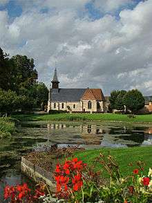
St.Martin Church
| Wikimedia Commons has media related to Lisors. |
This article is issued from Wikipedia - version of the 3/12/2016. The text is available under the Creative Commons Attribution/Share Alike but additional terms may apply for the media files.