Bueil
| Bueil | ||
|---|---|---|
 | ||
| ||
 Bueil | ||
|
Location within Normandy region  Bueil | ||
| Coordinates: 48°55′51″N 1°26′32″E / 48.9308°N 1.4422°ECoordinates: 48°55′51″N 1°26′32″E / 48.9308°N 1.4422°E | ||
| Country | France | |
| Region | Normandy | |
| Department | Eure | |
| Arrondissement | Évreux | |
| Canton | Pacy-sur-Eure | |
| Intercommunality | Portes de l'Eure | |
| Government | ||
| • Mayor (2008–2014) | Michel Duval | |
| Area1 | 4.91 km2 (1.90 sq mi) | |
| Population (2008)2 | 1,490 | |
| • Density | 300/km2 (790/sq mi) | |
| Time zone | CET (UTC+1) | |
| • Summer (DST) | CEST (UTC+2) | |
| INSEE/Postal code | 27119 / 27730 | |
| Elevation |
47–136 m (154–446 ft) (avg. 64 m or 210 ft) | |
|
1 French Land Register data, which excludes lakes, ponds, glaciers > 1 km² (0.386 sq mi or 247 acres) and river estuaries. 2 Population without double counting: residents of multiple communes (e.g., students and military personnel) only counted once. | ||

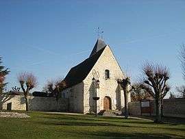
Bueil is a commune in the Eure department in Haute-Normandie in northern France.
Population
| Historical population | ||
|---|---|---|
| Year | Pop. | ±% |
| 1962 | 444 | — |
| 1968 | 455 | +2.5% |
| 1975 | 526 | +15.6% |
| 1982 | 1,003 | +90.7% |
| 1990 | 1,331 | +32.7% |
| 1999 | 1,393 | +4.7% |
| 2008 | 1,490 | +7.0% |
See also
References
| Wikimedia Commons has media related to Bueil (Eure). |
This article is issued from Wikipedia - version of the 8/16/2016. The text is available under the Creative Commons Attribution/Share Alike but additional terms may apply for the media files.