Saint-Aquilin-de-Pacy
| Saint-Aquilin-de-Pacy | ||
|---|---|---|
|
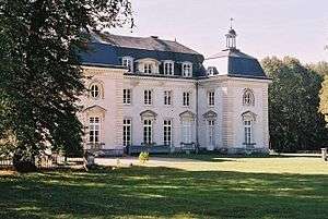
Chateau of the Buisson de May | ||
| ||
 Saint-Aquilin-de-Pacy | ||
|
Location within Normandy region  Saint-Aquilin-de-Pacy | ||
| Coordinates: 49°00′45″N 1°21′39″E / 49.0125°N 1.3608°ECoordinates: 49°00′45″N 1°21′39″E / 49.0125°N 1.3608°E | ||
| Country | France | |
| Region | Normandy | |
| Department | Eure | |
| Arrondissement | Évreux | |
| Canton | Pacy-sur-Eure | |
| Intercommunality | Portes de l'Eure | |
| Government | ||
| • Mayor (2008–2014) | Jean-Pierre Metayer | |
| Area1 | 8.5 km2 (3.3 sq mi) | |
| Population (2008)2 | 557 | |
| • Density | 66/km2 (170/sq mi) | |
| Time zone | CET (UTC+1) | |
| • Summer (DST) | CEST (UTC+2) | |
| INSEE/Postal code | 27510 / 27120 | |
| Elevation |
38–136 m (125–446 ft) (avg. 38 m or 125 ft) | |
|
1 French Land Register data, which excludes lakes, ponds, glaciers > 1 km² (0.386 sq mi or 247 acres) and river estuaries. 2 Population without double counting: residents of multiple communes (e.g., students and military personnel) only counted once. | ||

Saint-Aquilin-de-Pacy is a commune in the Eure department in Haute-Normandie in northern France.
Population
| Historical population | ||
|---|---|---|
| Year | Pop. | ±% |
| 1962 | 434 | — |
| 1968 | 454 | +4.6% |
| 1975 | 466 | +2.6% |
| 1982 | 444 | −4.7% |
| 1990 | 439 | −1.1% |
| 1999 | 529 | +20.5% |
| 2008 | 557 | +5.3% |
See also
References
| Wikimedia Commons has media related to Saint-Aquilin-de-Pacy. |
This article is issued from Wikipedia - version of the 2/18/2016. The text is available under the Creative Commons Attribution/Share Alike but additional terms may apply for the media files.