Washington County, Illinois
| Washington County, Illinois | |||
|---|---|---|---|
 Washington County Courthouse in Nashville | |||
| |||
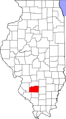 Location in the U.S. state of Illinois | |||
 Illinois's location in the U.S. | |||
| Founded | January 2, 1818 | ||
| Named for | George Washington | ||
| Seat | Nashville | ||
| Largest city | Nashville | ||
| Area | |||
| • Total | 564 sq mi (1,461 km2) | ||
| • Land | 563 sq mi (1,458 km2) | ||
| • Water | 1.3 sq mi (3 km2), 0.2% | ||
| Population | |||
| • (2010) | 14,716 | ||
| • Density | 26/sq mi (10/km²) | ||
| Congressional district | 15th | ||
| Time zone | Central: UTC-6/-5 | ||
| Website |
www | ||


Washington County is a county located in the U.S. state of Illinois. According to the 2010 census, it had a population of 14,716.[1] Its county seat is Nashville.[2] It is located in the southern portion of Illinois known locally as "Little Egypt".
History
Washington County was formed on January 2, 1818 out of St. Clair County. It was named for George Washington. Despite its relative proximity to the Illinois suburbs of St. Louis, Missouri, the county is not considered part of the St. Louis metropolitan area, also known as the Metro-East.
 Washington County from its 1818 creation to 1824
 Washington County in 1824, reduced to its current borders by the creation of Clinton County
Geography
According to the U.S. Census Bureau, the county has a total area of 564 square miles (1,460 km2), of which 563 square miles (1,460 km2) is land and 1.3 square miles (3.4 km2) (0.2%) is water.[3] There are many lakes, rivers, streams, and creeks in this area, including the Kaskaskia River, which is the county's northern border.
Climate and weather
| Nashville, Illinois | ||||||||||||||||||||||||||||||||||||||||||||||||||||||||||||
|---|---|---|---|---|---|---|---|---|---|---|---|---|---|---|---|---|---|---|---|---|---|---|---|---|---|---|---|---|---|---|---|---|---|---|---|---|---|---|---|---|---|---|---|---|---|---|---|---|---|---|---|---|---|---|---|---|---|---|---|---|
| Climate chart (explanation) | ||||||||||||||||||||||||||||||||||||||||||||||||||||||||||||
| ||||||||||||||||||||||||||||||||||||||||||||||||||||||||||||
| ||||||||||||||||||||||||||||||||||||||||||||||||||||||||||||
In recent years, average temperatures in Nashville have ranged from a low of 22 °F (−6 °C) in January to a high of 88 °F (31 °C) in July, although a record low of −21 °F (−29 °C) was recorded in December 1989 and a record high of 106 °F (41 °C) was recorded in July 1980. Average monthly precipitation ranged from 2.18 inches (55 mm) in January to 4.10 inches (104 mm) in May.[4] On November 17, 2013, an EF4 tornado swept through the area, destroying homes and causing two fatalities.
Major highways
Adjacent counties
- Clinton County (north)
- Marion County (northeast)
- Jefferson County (east)
- Perry County (south)
- Randolph County (southwest)
- St. Clair County (west)
Demographics
| Historical population | |||
|---|---|---|---|
| Census | Pop. | %± | |
| 1820 | 1,517 | — | |
| 1830 | 1,675 | 10.4% | |
| 1840 | 4,810 | 187.2% | |
| 1850 | 6,953 | 44.6% | |
| 1860 | 13,731 | 97.5% | |
| 1870 | 17,599 | 28.2% | |
| 1880 | 21,112 | 20.0% | |
| 1890 | 19,262 | −8.8% | |
| 1900 | 19,526 | 1.4% | |
| 1910 | 18,759 | −3.9% | |
| 1920 | 18,035 | −3.9% | |
| 1930 | 16,286 | −9.7% | |
| 1940 | 15,801 | −3.0% | |
| 1950 | 14,460 | −8.5% | |
| 1960 | 13,569 | −6.2% | |
| 1970 | 13,780 | 1.6% | |
| 1980 | 15,472 | 12.3% | |
| 1990 | 14,965 | −3.3% | |
| 2000 | 15,148 | 1.2% | |
| 2010 | 14,716 | −2.9% | |
| Est. 2015 | 14,270 | [5] | −3.0% |
| U.S. Decennial Census[6] 1790-1960[7] 1900-1990[8] 1990-2000[9] 2010-2013[1] | |||
As of the 2010 United States Census, there were 14,716 people, 5,926 households, and 4,112 families residing in the county.[10] The population density was 26.2 inhabitants per square mile (10.1/km2). There were 6,534 housing units at an average density of 11.6 per square mile (4.5/km2).[3] The racial makeup of the county was 97.7% white, 0.7% black or African American, 0.3% Asian, 0.1% American Indian, 0.4% from other races, and 0.8% from two or more races. Those of Hispanic or Latino origin made up 1.3% of the population.[10] In terms of ancestry, 53.6% were German, 14.0% were Polish, 13.1% were Irish, 7.7% were English, and 6.1% were American.[11]
Of the 5,926 households, 30.1% had children under the age of 18 living with them, 57.6% were married couples living together, 7.3% had a female householder with no husband present, 30.6% were non-families, and 25.9% of all households were made up of individuals. The average household size was 2.44 and the average family size was 2.93. The median age was 42.3 years.[10]
The median income for a household in the county was $51,440 and the median income for a family was $64,171. Males had a median income of $44,272 versus $30,683 for females. The per capita income for the county was $24,846. About 5.5% of families and 9.1% of the population were below the poverty line, including 13.2% of those under age 18 and 8.9% of those age 65 or over.[12]
Education
The county is served by six school districts:[13]
- Oakdale CCSD 1
- West Washington County CUD 10
- Irvington CCSD 11
- Ashley CCSD 15
- Nashville CCSD 49
- Nashville Community High School District 99
Communities
Cities
Villages
Unincorporated communities
Townships
Washington County is divided into these townships:
See also
References
- Specific
- 1 2 "State & County QuickFacts". United States Census Bureau. Retrieved July 9, 2014.
- ↑ "Find a County". National Association of Counties. Archived from the original on 2011-05-31. Retrieved 2011-06-07.
- 1 2 "Population, Housing Units, Area, and Density: 2010 - County". United States Census Bureau. Retrieved 2015-07-12.
- 1 2 "Monthly Averages for Nashville, Illinois". The Weather Channel. Retrieved 2011-01-27.
- ↑ "County Totals Dataset: Population, Population Change and Estimated Components of Population Change: April 1, 2010 to July 1, 2015". Retrieved July 2, 2016.
- ↑ "U.S. Decennial Census". United States Census Bureau. Archived from the original on May 11, 2015. Retrieved July 9, 2014.
- ↑ "Historical Census Browser". University of Virginia Library. Retrieved July 9, 2014.
- ↑ "Population of Counties by Decennial Census: 1900 to 1990". United States Census Bureau. Retrieved July 9, 2014.
- ↑ "Census 2000 PHC-T-4. Ranking Tables for Counties: 1990 and 2000" (PDF). United States Census Bureau. Retrieved July 9, 2014.
- 1 2 3 "DP-1 Profile of General Population and Housing Characteristics: 2010 Demographic Profile Data". United States Census Bureau. Retrieved 2015-07-12.
- ↑ "DP02 SELECTED SOCIAL CHARACTERISTICS IN THE UNITED STATES – 2006-2010 American Community Survey 5-Year Estimates". United States Census Bureau. Retrieved 2015-07-12.
- ↑ "DP03 SELECTED ECONOMIC CHARACTERISTICS – 2006-2010 American Community Survey 5-Year Estimates". United States Census Bureau. Retrieved 2015-07-12.
- ↑ Education, Illinois State Board of. "Illinois Public School Districts by County" (XLS). Retrieved 2009-05-28.
- General
External links
 |
Clinton County | Marion County | | |
| St. Clair County | |
Jefferson County | ||
| ||||
| | ||||
| Randolph County | Perry County |
Municipalities and communities of Washington County, Illinois, United States | ||
|---|---|---|
| Cities | ||
| Villages | ||
| Townships | ||
| Unincorporated communities | ||
| Footnotes | ‡This populated place also has portions in an adjacent county or counties | |

| Counties | 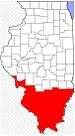 | |
|---|---|---|
| Mid-sized cities (25,000+) | ||
| Small Cities (10,000-25,000) | ||
| Small Cities (5,000-10,000) | ||
| Interstates | ||
| Airports/Military bases |
| |
| Universities | ||
| Colleges | ||
| Sports teams based in the Southern Illinois | ||
Coordinates: 38°21′08″N 89°24′38″W / 38.35222°N 89.41056°W