Piatt County, Illinois
| Piatt County, Illinois | |
|---|---|
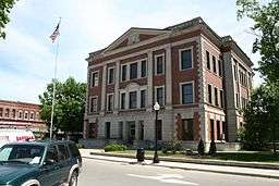 Piatt County Illinois Courthouse in Monticello | |
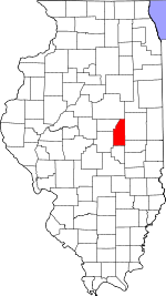 Location in the U.S. state of Illinois | |
 Illinois's location in the U.S. | |
| Founded | 1841 |
| Seat | Monticello |
| Largest city | Monticello |
| Area | |
| • Total | 439 sq mi (1,137 km2) |
| • Land | 439 sq mi (1,137 km2) |
| • Water | 0.3 sq mi (1 km2), 0.06% |
| Population | |
| • (2010) | 16,729 |
| • Density | 38/sq mi (15/km²) |
| Congressional district | 13th |
| Time zone | Central: UTC-6/-5 |
| Website |
www |
Piatt County is a county located in the U.S. state of Illinois. According to the 2010 census, it had a population of 16,729.[1] Its county seat is Monticello.[2]
Piatt County is part of the Champaign–Urbana, IL Metropolitan Statistical Area.
History
The first settler was a Quaker named George Haworth, followed by James Martin, Abraham Hanline, Solomon Carter and William Cordell.
Piatt County was formed in 1841 from Macon and Dewitt counties. Two local residents, James A. Piatt and Jesse Warner, were instrumental in forming the county. It was named after James A. Piatt after winning a coin flip against Jesse Warner.
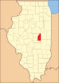 Piatt County at the time of its creation in 1841
Abraham Lincoln practiced law in Piatt County as a circuit lawyer. Lincoln and Stephen A. Douglas planned their presidential debates in Piatt County in 1858, one of which is ornamented by a marker just south of Monticello.
The first courthouse was built in 1843 but replaced by the current courthouse, which was finished in 1904.
Illinois Power Company was a major electric utility in Central Illinois, centered in Decatur, to the west of Piatt County. At one time, Illinois had a "personal property tax", an ad valorem tax levied by the counties on property that was not real estate. The personal property tax was a major expense for the electric utilities, since their generators and transmission lines were "personal property". Under Illinois law, a corporation, such as Illinois Power, paid personal property tax to the county in which the corporate headquarters was located. Because Piatt County offered a low tax rate, Illinois Power moved its corporate headquarters to that county. This allowed Piatt County to tax utility assets over half of the state, providing a rich source of revenue which was responsible for much of the wealth of this tiny county.
Geography
According to the U.S. Census Bureau, the county has a total area of 439 square miles (1,140 km2), of which 439 square miles (1,140 km2) is land and 0.3 square miles (0.78 km2) (0.06%) is water.[3]
Climate and weather
| Monticello, Illinois | ||||||||||||||||||||||||||||||||||||||||||||||||||||||||||||
|---|---|---|---|---|---|---|---|---|---|---|---|---|---|---|---|---|---|---|---|---|---|---|---|---|---|---|---|---|---|---|---|---|---|---|---|---|---|---|---|---|---|---|---|---|---|---|---|---|---|---|---|---|---|---|---|---|---|---|---|---|
| Climate chart (explanation) | ||||||||||||||||||||||||||||||||||||||||||||||||||||||||||||
| ||||||||||||||||||||||||||||||||||||||||||||||||||||||||||||
| ||||||||||||||||||||||||||||||||||||||||||||||||||||||||||||
In recent years, average temperatures in the county seat of Monticello have ranged from a low of 14 °F (−10 °C) in January to a high of 85 °F (29 °C) in July, although a record low of −25 °F (−32 °C) was recorded in January 1999 and a record high of 105 °F (41 °C) was recorded in July 1966. Average monthly precipitation ranged from 1.61 inches (41 mm) in January to 3.99 inches (101 mm) in August.[4]
Major highways
Adjacent counties
- McLean County - north
- Champaign County - east
- Douglas County - southeast
- Moultrie County - south
- Macon County - southwest
- De Witt County - west
Demographics
| Historical population | |||
|---|---|---|---|
| Census | Pop. | %± | |
| 1850 | 1,606 | — | |
| 1860 | 6,127 | 281.5% | |
| 1870 | 10,953 | 78.8% | |
| 1880 | 15,583 | 42.3% | |
| 1890 | 17,062 | 9.5% | |
| 1900 | 17,706 | 3.8% | |
| 1910 | 16,376 | −7.5% | |
| 1920 | 15,714 | −4.0% | |
| 1930 | 15,588 | −0.8% | |
| 1940 | 14,659 | −6.0% | |
| 1950 | 13,970 | −4.7% | |
| 1960 | 14,960 | 7.1% | |
| 1970 | 15,509 | 3.7% | |
| 1980 | 16,581 | 6.9% | |
| 1990 | 15,548 | −6.2% | |
| 2000 | 16,365 | 5.3% | |
| 2010 | 16,729 | 2.2% | |
| Est. 2015 | 16,387 | [5] | −2.0% |
| U.S. Decennial Census[6] 1790-1960[7] 1900-1990[8] 1990-2000[9] 2010-2013[1] | |||
As of the 2010 United States Census, there were 16,729 people, 6,782 households, and 4,823 families residing in the county.[10] The population density was 38.1 inhabitants per square mile (14.7/km2). There were 7,269 housing units at an average density of 16.6 per square mile (6.4/km2).[3] The racial makeup of the county was 98.0% white, 0.3% black or African American, 0.3% Asian, 0.2% American Indian, 0.2% from other races, and 0.9% from two or more races. Those of Hispanic or Latino origin made up 1.0% of the population.[10] In terms of ancestry, 26.1% were German, 21.9% were American, 15.2% were English, and 13.4% were Irish.[11]
Of the 6,782 households, 32.0% had children under the age of 18 living with them, 59.4% were married couples living together, 8.0% had a female householder with no husband present, 28.9% were non-families, and 24.5% of all households were made up of individuals. The average household size was 2.46 and the average family size was 2.92. The median age was 42.6 years.[10]
The median income for a household in the county was $55,752 and the median income for a family was $65,850. Males had a median income of $50,425 versus $32,304 for females. The per capita income for the county was $26,492. About 5.1% of families and 7.6% of the population were below the poverty line, including 10.8% of those under age 18 and 4.5% of those age 65 or over.[12]
Communities

City
Villages
Unincorporated towns
Former places
- Blue Ridge
- Centerville
- Combs
- Harris
- Unity
- Voorhies
- Willow Branch
Townships
Piatt County is divided into eight townships:
See also
References
- 1 2 "State & County QuickFacts". United States Census Bureau. Retrieved July 8, 2014.
- ↑ "Find a County". National Association of Counties. Retrieved 2011-06-07.
- 1 2 "Population, Housing Units, Area, and Density: 2010 - County". United States Census Bureau. Retrieved 2015-07-12.
- 1 2 "Monthly Averages for Monticello, Illinois". The Weather Channel. Retrieved 2011-01-27.
- ↑ "County Totals Dataset: Population, Population Change and Estimated Components of Population Change: April 1, 2010 to July 1, 2015". Retrieved July 2, 2016.
- ↑ "U.S. Decennial Census". United States Census Bureau. Retrieved July 8, 2014.
- ↑ "Historical Census Browser". University of Virginia Library. Retrieved July 8, 2014.
- ↑ "Population of Counties by Decennial Census: 1900 to 1990". United States Census Bureau. Retrieved July 8, 2014.
- ↑ "Census 2000 PHC-T-4. Ranking Tables for Counties: 1990 and 2000" (PDF). United States Census Bureau. Retrieved July 8, 2014.
- 1 2 3 "DP-1 Profile of General Population and Housing Characteristics: 2010 Demographic Profile Data". United States Census Bureau. Retrieved 2015-07-12.
- ↑ "DP02 SELECTED SOCIAL CHARACTERISTICS IN THE UNITED STATES – 2006-2010 American Community Survey 5-Year Estimates". United States Census Bureau. Retrieved 2015-07-12.
- ↑ "DP03 SELECTED ECONOMIC CHARACTERISTICS – 2006-2010 American Community Survey 5-Year Estimates". United States Census Bureau. Retrieved 2015-07-12.
 |
McLean County | | ||
| De Witt County | |
Champaign County | ||
| ||||
| | ||||
| Macon County | Moultrie County | Douglas County |
Municipalities and communities of Piatt County, Illinois, United States | ||
|---|---|---|
| City | ||
| Villages | ||
| Townships | ||
| CDPs | ||
| Other unincorporated communities | ||
| Footnotes | ‡This populated place also has portions in an adjacent county or counties | |

Coordinates: 40°01′N 88°35′W / 40.01°N 88.59°W