Clay County, Illinois
| Clay County, Illinois | |
|---|---|
 Clay County Courthouse in Louisville | |
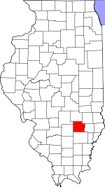 Location in the U.S. state of Illinois | |
 Illinois's location in the U.S. | |
| Founded | 1824 |
| Named for | Henry Clay |
| Seat | Louisville |
| Largest city | Flora |
| Area | |
| • Total | 470 sq mi (1,217 km2) |
| • Land | 468 sq mi (1,212 km2) |
| • Water | 1.3 sq mi (3 km2), 0.3% |
| Population | |
| • (2010) | 13,815 |
| • Density | 29/sq mi (11/km²) |
| Congressional district | 15th |
| Time zone | Central: UTC-6/-5 |
Clay County is a county located in the U.S. state of Illinois. As of the 2010 census, the population was 13,815.[1] Its county seat is Louisville.[2]
In 1950, the U.S. Census Bureau placed the mean center of U.S. population in Clay County.[3]
History
Clay County was formed in 1824 out of portions of Wayne, Crawford, and Fayette counties. Its name is in honor of Henry Clay,[4] famous American statesman, member of the United States Senate from Kentucky and United States Secretary of State in the 19th century. Clay was an unsuccessful candidate for President in the year the County was named.
-
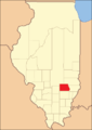
Clay County from the time of its creation to 1831
-
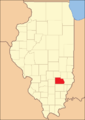
Clay County between 1831 and 1841
-

Clay County was reduced to its current size in 1841 by the creation of Richland County.
Geography
According to the U.S. Census Bureau, the county has a total area of 470 square miles (1,200 km2), of which 468 square miles (1,210 km2) is land and 1.3 square miles (3.4 km2) (0.3%) is water.[5]
Adjacent counties
- Jasper County - northeast
- Richland County - east
- Wayne County - south
- Marion County - west
- Fayette County - northwest
- Effingham County - north
Major highways
Climate and weather
| Louisville, Illinois | ||||||||||||||||||||||||||||||||||||||||||||||||||||||||||||
|---|---|---|---|---|---|---|---|---|---|---|---|---|---|---|---|---|---|---|---|---|---|---|---|---|---|---|---|---|---|---|---|---|---|---|---|---|---|---|---|---|---|---|---|---|---|---|---|---|---|---|---|---|---|---|---|---|---|---|---|---|
| Climate chart (explanation) | ||||||||||||||||||||||||||||||||||||||||||||||||||||||||||||
| ||||||||||||||||||||||||||||||||||||||||||||||||||||||||||||
| ||||||||||||||||||||||||||||||||||||||||||||||||||||||||||||
In recent years, average temperatures in the county seat of Louisville have ranged from a low of 21 °F (−6 °C) in January to a high of 89 °F (32 °C) in July, although a record low of −25 °F (−32 °C) was recorded in January 1904 and a record high of 111 °F (44 °C) was recorded in July 1936. Average monthly precipitation ranged from 2.49 inches (63 mm) in February to 4.34 inches (110 mm) in June.[6]
Demographics
| Historical population | |||
|---|---|---|---|
| Census | Pop. | %± | |
| 1830 | 755 | — | |
| 1840 | 3,228 | 327.5% | |
| 1850 | 4,289 | 32.9% | |
| 1860 | 9,336 | 117.7% | |
| 1870 | 15,875 | 70.0% | |
| 1880 | 16,192 | 2.0% | |
| 1890 | 16,772 | 3.6% | |
| 1900 | 19,553 | 16.6% | |
| 1910 | 18,661 | −4.6% | |
| 1920 | 17,684 | −5.2% | |
| 1930 | 16,155 | −8.6% | |
| 1940 | 18,947 | 17.3% | |
| 1950 | 17,445 | −7.9% | |
| 1960 | 15,815 | −9.3% | |
| 1970 | 14,735 | −6.8% | |
| 1980 | 15,283 | 3.7% | |
| 1990 | 14,460 | −5.4% | |
| 2000 | 14,560 | 0.7% | |
| 2010 | 13,815 | −5.1% | |
| Est. 2015 | 13,428 | [7] | −2.8% |
| U.S. Decennial Census[8] 1790-1960[9] 1900-1990[10] 1990-2000[11] 2010-2013[1] | |||
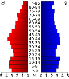
As of the 2010 United States Census, there were 13,815 people, 5,697 households, and 3,790 families residing in the county.[12] The population density was 29.5 inhabitants per square mile (11.4/km2). There were 6,404 housing units at an average density of 13.7 per square mile (5.3/km2).[5] The racial makeup of the county was 97.7% white, 0.5% Asian, 0.3% black or African American, 0.2% American Indian, 0.5% from other races, and 0.8% from two or more races. Those of Hispanic or Latino origin made up 1.1% of the population.[12] In terms of ancestry, 21.7% were German, 14.6% were American, 12.6% were Irish, and 8.6% were English.[13]
Of the 5,697 households, 29.5% had children under the age of 18 living with them, 52.1% were married couples living together, 9.4% had a female householder with no husband present, 33.5% were non-families, and 28.9% of all households were made up of individuals. The average household size was 2.37 and the average family size was 2.89. The median age was 42.2 years.[12]
The median income for a household in the county was $38,016 and the median income for a family was $48,659. Males had a median income of $38,191 versus $27,347 for females. The per capita income for the county was $20,802. About 11.2% of families and 16.3% of the population were below the poverty line, including 21.4% of those under age 18 and 14.7% of those age 65 or over.[14]
Education
- Clay City Community Unit District 10
- Dieterich Community Unit School District 30
- Effingham Community Unit School District 40
- Flora Community Unit School District 35
- Jasper County Community Unit School District 1
- North Clay Community Unit School District 25
- South Central Community Unit School District 401
- West Richland Community Unit School District 2
Communities
Cities
Villages
Townships
Clay County is divided into these twelve townships:
See also
Coordinates: 38°46′N 88°29′W / 38.76°N 88.49°W
References
- Specific
- 1 2 "State & County QuickFacts". United States Census Bureau. Retrieved July 4, 2014.
- ↑ "Find a County". National Association of Counties. Archived from the original on 2011-05-31. Retrieved 2011-06-07.
- ↑ "Mean Center of Population for the United States: 1790 to 2000" (PDF). United States Census Bureau. Retrieved 2011-09-17.
- ↑ Gannett, Henry (1905). The Origin of Certain Place Names in the United States. Govt. Print. Off. p. 83.
- 1 2 "Population, Housing Units, Area, and Density: 2010 - County". United States Census Bureau. Retrieved 2015-07-11.
- 1 2 "Monthly Averages for Louisville, Illinois". The Weather Channel. Retrieved 2011-01-27.
- ↑ "County Totals Dataset: Population, Population Change and Estimated Components of Population Change: April 1, 2010 to July 1, 2015". Retrieved July 2, 2016.
- ↑ "U.S. Decennial Census". United States Census Bureau. Archived from the original on May 11, 2015. Retrieved July 4, 2014.
- ↑ "Historical Census Browser". University of Virginia Library. Retrieved July 4, 2014.
- ↑ "Population of Counties by Decennial Census: 1900 to 1990". United States Census Bureau. Retrieved July 4, 2014.
- ↑ "Census 2000 PHC-T-4. Ranking Tables for Counties: 1990 and 2000" (PDF). United States Census Bureau. Retrieved July 4, 2014.
- 1 2 3 "DP-1 Profile of General Population and Housing Characteristics: 2010 Demographic Profile Data". United States Census Bureau. Retrieved 2015-07-11.
- ↑ "DP02 SELECTED SOCIAL CHARACTERISTICS IN THE UNITED STATES – 2006-2010 American Community Survey 5-Year Estimates". United States Census Bureau. Retrieved 2015-07-11.
- ↑ "DP03 SELECTED ECONOMIC CHARACTERISTICS – 2006-2010 American Community Survey 5-Year Estimates". United States Census Bureau. Retrieved 2015-07-11.
- General
- United States Census Bureau 2007 TIGER/Line Shapefiles
- United States Board on Geographic Names (GNIS)
- United States National Atlas
External links
 |
Fayette County | Effingham County | Jasper County | |
| Marion County | |
Richland County | ||
| ||||
| | ||||
| Wayne County |
Municipalities and communities of Clay County, Illinois, United States | ||
|---|---|---|
| City | ||
| Villages | ||
| Townships | ||
| Unincorporated communities | ||
| Ghost town | ||
| Footnotes | ‡This populated place also has portions in an adjacent county or counties | |

| Counties | 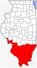 | |
|---|---|---|
| Mid-sized cities (25,000+) | ||
| Small Cities (10,000-25,000) | ||
| Small Cities (5,000-10,000) | ||
| Interstates | ||
| Airports/Military bases |
| |
| Universities | ||
| Colleges | ||
| Sports teams based in the Southern Illinois | ||