Jackson County, Illinois
| Jackson County, Illinois | |
|---|---|
 Jackson County Courthouse in Murphysboro | |
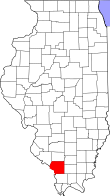 Location in the U.S. state of Illinois | |
 Illinois's location in the U.S. | |
| Founded | 1816 |
| Named for | Andrew Jackson |
| Seat | Murphysboro |
| Largest city | Carbondale |
| Area | |
| • Total | 602 sq mi (1,559 km2) |
| • Land | 584 sq mi (1,513 km2) |
| • Water | 18 sq mi (47 km2), 3.0% |
| Population | |
| • (2010) | 60,218 |
| • Density | 103/sq mi (40/km²) |
| Congressional district | 12th |
| Time zone | Central: UTC-6/-5 |
| Website |
www |
Jackson County is a county located in the U.S. state of Illinois with a population of 60,218 at the 2010 census.[1] Its county seat is Murphysboro,[2] and its most populous city is Carbondale, home to the main campus of Southern Illinois University. The county was incorporated on January 10, 1816 and named for Andrew Jackson.
Jackson County is included in the Carbondale-Marion, IL Metropolitan Statistical Area. It is located in the southern portion of Illinois known locally as "Little Egypt".
History
Human occupation of Jackson County began about 11,500 years ago. Extensive documentation of the areas indigenous peoples has been conducted and is ongoing. Exploration from the European explorers began with the Joliet-Marquette exploration along the Mississippi River. It was not until the 18th and 19th century when pioneer farmers began to settle in the area's inexpensive land along the Mississippi River and in the forested Shawnee hills with its one-hundred-foot trees.
As early as 1813, Conrad Will, namesake of Will County, conducted a large salt extraction operation using slave labor on the banks of the Big Muddy River, south of today's Murphysboro. As this was in the "free" Northwest Territory, Will had to have a legal exemption to own slaves.
Jackson County was organized in 1816, having been carved out of Randolph County. It was named for Andrew Jackson, who had just defeated the British Army at the Battle of New Orleans.[3]
Shortly after the American Civil War, General John A. Logan led a parade of veterans from Murphysboro to Carbondale, Illinois. General Logan, himself a Union veteran, invited the Confederate veterans, of which there were many in somewhat divided Jackson County, to march with him. What might have been another celebration of the Union victory became a memorial to the war dead on both sides. This is one possibility of the origin of the Memorial Day holiday.
In 1925 the great Tri-State Tornado ripped through Jackson County on March 18, leaving devastation in its path. The villages of Gorham and DeSoto and the city of Murphysboro were especially hit hard.
The county courthouse is in downtown Murphysboro. The current reinforced concrete courthouse replaced earlier wooden structures and was built during 1927-28. The original county seat was Brownsville along the Big Muddy River, but after the courthouse was destroyed by fire, the county government was moved upstream a few miles to Murphysboro. Few traces now remain of the old town of Brownsville. On February 27, 1843, the Illinois General Assembly created a commission to designate a new county seat for Jackson County.
 Jackson County at the time of its creation to 1818, including unorganized territory (formerly part of Johnson County) temporarily attached to it.[4]
 Jackson County between 1818 and 1827
 Jackson County in 1827, when it was reduced slightly to its current size
Geography
According to the U.S. Census Bureau, the county has a total area of 602 square miles (1,560 km2), of which 584 square miles (1,510 km2) is land and 18 square miles (47 km2) (3.0%) is water.[5] The average elevation is around 400 feet (120 m), except near the Mississippi River.
The first coal mine in Illinois was opened on the south bank of the Big Muddy River near the present-day Route 127 Bridge.
Climate and weather
| Murphysboro, Illinois | ||||||||||||||||||||||||||||||||||||||||||||||||||||||||||||
|---|---|---|---|---|---|---|---|---|---|---|---|---|---|---|---|---|---|---|---|---|---|---|---|---|---|---|---|---|---|---|---|---|---|---|---|---|---|---|---|---|---|---|---|---|---|---|---|---|---|---|---|---|---|---|---|---|---|---|---|---|
| Climate chart (explanation) | ||||||||||||||||||||||||||||||||||||||||||||||||||||||||||||
| ||||||||||||||||||||||||||||||||||||||||||||||||||||||||||||
| ||||||||||||||||||||||||||||||||||||||||||||||||||||||||||||
In recent years, average temperatures in the county seat of Murphysboro have ranged from a low of 21 °F (−6 °C) in January to a high of 88 °F (31 °C) in July, although a record low of −25 °F (−32 °C) was recorded in January 1977 and a record high of 113 °F (45 °C) was recorded in August 1930. Average monthly precipitation ranged from 2.91 inches (74 mm) in January to 4.78 inches (121 mm) in May.[6]
Major highways
 U.S. Highway 51
 Illinois Route 3
 Illinois Route 4
 Illinois Route 13
 Illinois Route 127
 Illinois Route 149
 Illinois Route 151
Adjacent counties
- Perry County - north
- Franklin County - northeast
- Williamson County - east
- Union County - southeast
- Perry County, Missouri - west
- Randolph County - northwest
National protected areas
- Crab Orchard National Wildlife Refuge (part)
- Shawnee National Forest (part)
Demographics

| Historical population | |||
|---|---|---|---|
| Census | Pop. | %± | |
| 1820 | 1,542 | — | |
| 1830 | 1,828 | 18.5% | |
| 1840 | 3,566 | 95.1% | |
| 1850 | 5,862 | 64.4% | |
| 1860 | 9,589 | 63.6% | |
| 1870 | 19,634 | 104.8% | |
| 1880 | 22,505 | 14.6% | |
| 1890 | 27,809 | 23.6% | |
| 1900 | 33,871 | 21.8% | |
| 1910 | 35,143 | 3.8% | |
| 1920 | 37,091 | 5.5% | |
| 1930 | 35,680 | −3.8% | |
| 1940 | 37,920 | 6.3% | |
| 1950 | 38,124 | 0.5% | |
| 1960 | 42,151 | 10.6% | |
| 1970 | 55,008 | 30.5% | |
| 1980 | 61,522 | 11.8% | |
| 1990 | 61,067 | −0.7% | |
| 2000 | 59,612 | −2.4% | |
| 2010 | 60,218 | 1.0% | |
| Est. 2015 | 59,362 | [7] | −1.4% |
| U.S. Decennial Census[8] 1790-1960[9] 1900-1990[10] 1990-2000[11] 2010-2013[1] | |||
As of the 2010 United States Census, there were 60,218 people, 25,538 households, and 12,621 families residing in the county.[12] The population density was 103.1 inhabitants per square mile (39.8/km2). There were 28,578 housing units at an average density of 48.9 per square mile (18.9/km2).[5] The racial makeup of the county was 77.8% white, 14.3% black or African American, 3.2% Asian, 0.4% American Indian, 0.1% Pacific islander, 1.6% from other races, and 2.6% from two or more races. Those of Hispanic or Latino origin made up 4.0% of the population.[12] In terms of ancestry, 26.0% were German, 14.5% were Irish, 10.6% were English, and 5.7% were American.[13]
Of the 25,538 households, 23.0% had children under the age of 18 living with them, 35.5% were married couples living together, 10.2% had a female householder with no husband present, 50.6% were non-families, and 35.1% of all households were made up of individuals. The average household size was 2.20 and the average family size was 2.87. The median age was 29.1 years.[12]
The median income for a household in the county was $32,169 and the median income for a family was $50,787. Males had a median income of $42,747 versus $31,244 for females. The per capita income for the county was $19,294. About 17.4% of families and 28.5% of the population were below the poverty line, including 32.1% of those under age 18 and 7.9% of those age 65 or over.[14]
Economy
Much of the county's economic situation is dependent upon Southern Illinois University Carbondale and the city of Carbondale. A rapidly developing city, it is part of the Metro Lakeland area consisting mainly of the major communities of Carbondale, Marion, Herrin, and Carterville. The outer regions of the Metro are include Murphysboro, the rest of Jackson County, the rest of Williamson County, Perry County, and Saline County. Jackson County is also located near the Shawnee Hills Wine Trail. Once a small business, the wine trail has evolved into a booming tourist attraction.
Communities
Cities
Villages
Townships
Jackson County is divided into sixteen townships:
See also
References
- 1 2 "State & County QuickFacts". United States Census Bureau. Retrieved July 6, 2014.
- ↑ "Find a County". National Association of Counties. Archived from the original on May 31, 2011. Retrieved 2011-06-07.
- ↑ Gannett, Henry (1905). The Origin of Certain Place Names in the United States. Govt. Print. Off. p. 167.
- ↑ White, Jesse. Origin and Evolution of Illinois Counties. State of Illinois, March 2010.
- 1 2 "Population, Housing Units, Area, and Density: 2010 - County". United States Census Bureau. Retrieved 2015-07-11.
- 1 2 "Monthly Averages for Murphysboro, Illinois". The Weather Channel. Retrieved 2011-01-27.
- ↑ "County Totals Dataset: Population, Population Change and Estimated Components of Population Change: April 1, 2010 to July 1, 2015". Retrieved July 2, 2016.
- ↑ "U.S. Decennial Census". United States Census Bureau. Archived from the original on May 11, 2015. Retrieved July 6, 2014.
- ↑ "Historical Census Browser". University of Virginia Library. Retrieved July 6, 2014.
- ↑ "Population of Counties by Decennial Census: 1900 to 1990". United States Census Bureau. Retrieved July 6, 2014.
- ↑ "Census 2000 PHC-T-4. Ranking Tables for Counties: 1990 and 2000" (PDF). United States Census Bureau. Retrieved July 6, 2014.
- 1 2 3 "DP-1 Profile of General Population and Housing Characteristics: 2010 Demographic Profile Data". United States Census Bureau. Retrieved 2015-07-11.
- ↑ "DP02 SELECTED SOCIAL CHARACTERISTICS IN THE UNITED STATES – 2006-2010 American Community Survey 5-Year Estimates". United States Census Bureau. Retrieved 2015-07-11.
- ↑ "DP03 SELECTED ECONOMIC CHARACTERISTICS – 2006-2010 American Community Survey 5-Year Estimates". United States Census Bureau. Retrieved 2015-07-11.
External links
 |
Randolph County | Perry County | Franklin County | |
| Perry County, Missouri | |
Williamson County | ||
| ||||
| | ||||
| Union County |
Municipalities and communities of Jackson County, Illinois, United States | ||
|---|---|---|
| Cities | ||
| Villages | ||
| Townships | ||
| CDP | ||
| Other unincorporated communities | ||
| Ghost town | ||
| Footnotes | ‡This populated place also has portions in an adjacent county or counties | |

| Counties |  | |
|---|---|---|
| Mid-sized cities (25,000+) | ||
| Small Cities (10,000-25,000) | ||
| Small Cities (5,000-10,000) | ||
| Interstates | ||
| Airports/Military bases |
| |
| Universities | ||
| Colleges | ||
| Sports teams based in the Southern Illinois | ||
Coordinates: 37°47′N 89°23′W / 37.79°N 89.38°W