Pulaski County, Illinois
| Pulaski County, Illinois | |
|---|---|
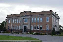 Pulaski County Courthouse, Mound City | |
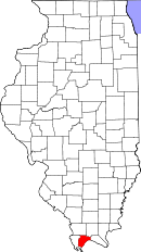 Location in the U.S. state of Illinois | |
 Illinois's location in the U.S. | |
| Founded | 1843 |
| Named for | Casimir Pulaski |
| Seat | Mound City |
| Largest city | Mounds |
| Area | |
| • Total | 203 sq mi (526 km2) |
| • Land | 199 sq mi (515 km2) |
| • Water | 4.0 sq mi (10 km2), 2.0% |
| Population | |
| • (2010) | 6,161 |
| • Density | 31/sq mi (12/km²) |
| Congressional district | 12th |
| Time zone | Central: UTC-6/-5 |
Pulaski County is a county located in the U.S. state of Illinois. According to the 2010 census, it had a population of 6,161.[1] Its county seat is Mound City.[2] It is located along the Ohio River in the portion of the state known locally as "Little Egypt".
History
Pulaski County was formed on March 3, 1843, out of parts of Alexander and Johnson counties. It was named in honor of Kazimierz Pułaski who was killed at the Siege of Savannah in the Revolutionary War.[3]
 Pulaski County at the time of its creation in 1843
Geography
According to the U.S. Census Bureau, the county has a total area of 203 square miles (530 km2), of which 199 square miles (520 km2) is land and 4.0 square miles (10 km2) (2.0%) is water.[4] It is the third-smallest county in Illinois by area.
Climate and weather
| Mound City, Illinois | ||||||||||||||||||||||||||||||||||||||||||||||||||||||||||||
|---|---|---|---|---|---|---|---|---|---|---|---|---|---|---|---|---|---|---|---|---|---|---|---|---|---|---|---|---|---|---|---|---|---|---|---|---|---|---|---|---|---|---|---|---|---|---|---|---|---|---|---|---|---|---|---|---|---|---|---|---|
| Climate chart (explanation) | ||||||||||||||||||||||||||||||||||||||||||||||||||||||||||||
| ||||||||||||||||||||||||||||||||||||||||||||||||||||||||||||
| ||||||||||||||||||||||||||||||||||||||||||||||||||||||||||||
In recent years, average temperatures in the county seat of Mound City have ranged from a low of 26 °F (−3 °C) in January to a high of 90 °F (32 °C) in July, although a record low of −12 °F (−24 °C) was recorded in January 1985 and a record high of 104 °F (40 °C) was recorded in June 1954. Average monthly precipitation ranged from 3.04 inches (77 mm) in September to 4.76 inches (121 mm) in May.[5]
Major highways
 Interstate 57, which has been listed as a speed trap.[6]
 U.S. Highway 51
 Illinois Route 37
 Illinois Route 169
Adjacent counties
- Union County (north)
- Johnson County (northeast)
- Massac County (east)
- Ballard County, Kentucky (southeast)
- Alexander County (west)
National protected area
Demographics
| Historical population | |||
|---|---|---|---|
| Census | Pop. | %± | |
| 1850 | 2,265 | — | |
| 1860 | 3,943 | 74.1% | |
| 1870 | 8,752 | 122.0% | |
| 1880 | 9,507 | 8.6% | |
| 1890 | 11,355 | 19.4% | |
| 1900 | 14,554 | 28.2% | |
| 1910 | 15,650 | 7.5% | |
| 1920 | 14,629 | −6.5% | |
| 1930 | 14,834 | 1.4% | |
| 1940 | 15,875 | 7.0% | |
| 1950 | 13,639 | −14.1% | |
| 1960 | 10,490 | −23.1% | |
| 1970 | 8,741 | −16.7% | |
| 1980 | 8,840 | 1.1% | |
| 1990 | 7,523 | −14.9% | |
| 2000 | 7,348 | −2.3% | |
| 2010 | 6,161 | −16.2% | |
| Est. 2015 | 5,678 | [7] | −7.8% |
| U.S. Decennial Census[8] 1790-1960[9] 1900-1990[10] 1990-2000[11] 2010-2013[1] | |||
As of the 2010 United States Census, there were 6,161 people, 2,642 households, and 1,658 families residing in the county.[12] The population density was 30.9 inhabitants per square mile (11.9/km2). There were 3,155 housing units at an average density of 15.8 per square mile (6.1/km2).[4] The racial makeup of the county was 64.4% white, 32.4% black or African American, 0.4% American Indian, 0.2% Asian, 0.7% from other races, and 1.9% from two or more races. Those of Hispanic or Latino origin made up 1.6% of the population.[12] In terms of ancestry, 15.1% were German, 6.8% were Irish, 6.6% were English, and 6.6% were American.[13]
Of the 2,642 households, 27.3% had children under the age of 18 living with them, 43.6% were married couples living together, 14.3% had a female householder with no husband present, 37.2% were non-families, and 33.4% of all households were made up of individuals. The average household size was 2.32 and the average family size was 2.96. The median age was 43.2 years.[12]
The median income for a household in the county was $31,173 and the median income for a family was $39,699. Males had a median income of $36,915 versus $29,007 for females. The per capita income for the county was $18,444. About 16.7% of families and 22.7% of the population were below the poverty line, including 32.0% of those under age 18 and 18.0% of those age 65 or over.[14]
Communities
Cities
Villages
Unincorporated communities
- America
- Levings
- North Mounds
- Perks
- Pryortown
- Spencer Heights
- Villa Ridge
- Wetaug
See also
Notes
- 1 2 "State & County QuickFacts". United States Census Bureau. Retrieved July 8, 2014.
- ↑ "Find a County". National Association of Counties. Retrieved 2011-06-07.
- ↑ Callary, Edward (2009). Place Names of Illinois. Urbana and Chicago, Illinois: University of Illinois Press. p. 287.
- 1 2 "Population, Housing Units, Area, and Density: 2010 - County". United States Census Bureau. Retrieved 2015-07-12.
- 1 2 "Monthly Averages for Mound City, Illinois". The Weather Channel. Retrieved 2011-01-27.
- ↑ http://www.speedtrap.org/view/illinois/125376
- ↑ "County Totals Dataset: Population, Population Change and Estimated Components of Population Change: April 1, 2010 to July 1, 2015". Retrieved July 2, 2016.
- ↑ "U.S. Decennial Census". United States Census Bureau. Retrieved July 8, 2014.
- ↑ "Historical Census Browser". University of Virginia Library. Retrieved July 8, 2014.
- ↑ "Population of Counties by Decennial Census: 1900 to 1990". United States Census Bureau. Retrieved July 8, 2014.
- ↑ "Census 2000 PHC-T-4. Ranking Tables for Counties: 1990 and 2000" (PDF). United States Census Bureau. Retrieved July 8, 2014.
- 1 2 3 "DP-1 Profile of General Population and Housing Characteristics: 2010 Demographic Profile Data". United States Census Bureau. Retrieved 2015-07-12.
- ↑ "DP02 SELECTED SOCIAL CHARACTERISTICS IN THE UNITED STATES – 2006-2010 American Community Survey 5-Year Estimates". United States Census Bureau. Retrieved 2015-07-12.
- ↑ "DP03 SELECTED ECONOMIC CHARACTERISTICS – 2006-2010 American Community Survey 5-Year Estimates". United States Census Bureau. Retrieved 2015-07-12.
References
- Perrin, William Henry, ed. (1883). History of Alexander, Union and Pulaski Counties, Illinois. Chicago: O. L. Baskin and Company, Historical Publishers.
 |
Union County | Johnson County | | |
| Alexander County | |
Massac County | ||
| ||||
| | ||||
| Ballard County, Kentucky |
Municipalities and communities of Pulaski County, Illinois, United States | ||
|---|---|---|
| Cities | ||
| Villages | ||
| Precincts |
| |
| Unincorporated communities |
| |
| Ghost town | ||

| Counties | 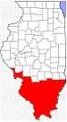 | |
|---|---|---|
| Mid-sized cities (25,000+) | ||
| Small Cities (10,000-25,000) | ||
| Small Cities (5,000-10,000) | ||
| Interstates | ||
| Airports/Military bases |
| |
| Universities | ||
| Colleges | ||
| Sports teams based in the Southern Illinois | ||
Coordinates: 37°14′N 89°08′W / 37.23°N 89.13°W