Mascoutah, Illinois
| Mascoutah | |
| City | |
| Country | United States |
|---|---|
| State | Illinois |
| County | St. Clair |
| Coordinates | 38°29.5′N 89°47.8′W / 38.4917°N 89.7967°WCoordinates: 38°29.5′N 89°47.8′W / 38.4917°N 89.7967°W |
| Area | 9.65 sq mi (25 km2) |
| - land | 9.50 sq mi (25 km2) |
| - water | 0.15 sq mi (0 km2) |
| Population | 7,483 (2010) |
| Density | 655.1/sq mi (253/km2) |
| Timezone | CST (UTC-6) |
| - summer (DST) | CDT (UTC-5) |
| Postal code | 62258 |
| Area code | 618 |
 Location in St. Clair County and the state of Illinois. | |
.svg.png) Location of Illinois in the United States | |
| Wikimedia Commons: Mascoutah, Illinois | |
| Website: www | |
Mascoutah is a small city in St. Clair County, Illinois, United States, named for the Mascoutens, a tribe of the Illinois Indians.[1] The population was 7,483 at the 2010 census.
Geography
The Mascoutah Civic Center is located at 38°29.5′N 89°47.8′W / 38.4917°N 89.7967°W (38.4922, -89.7968).[2]
According to the 2010 census, Mascoutah has a total area of 9.65 square miles (24.99 km2), of which 9.5 square miles (24.60 km2) (or 98.45%) is land and 0.15 square miles (0.39 km2) (or 1.55%) is water.[3]
Demographics
| Historical population | |||
|---|---|---|---|
| Census | Pop. | %± | |
| 1860 | 2,076 | — | |
| 1870 | 2,790 | 34.4% | |
| 1880 | 2,558 | −8.3% | |
| 1890 | 2,032 | −20.6% | |
| 1900 | 2,171 | 6.8% | |
| 1910 | 2,081 | −4.1% | |
| 1920 | 2,343 | 12.6% | |
| 1930 | 2,311 | −1.4% | |
| 1940 | 2,294 | −0.7% | |
| 1950 | 3,009 | 31.2% | |
| 1960 | 3,625 | 20.5% | |
| 1970 | 5,045 | 39.2% | |
| 1980 | 4,962 | −1.6% | |
| 1990 | 5,511 | 11.1% | |
| 2000 | 5,659 | 2.7% | |
| 2010 | 7,483 | 32.2% | |
| Est. 2015 | 7,975 | [4] | 6.6% |
Mascoutah was the United States center of population point in 1970. As of the census[6] of 2000, there were 5,659 people, 2,162 households, and 1,571 families residing in the city. The population density was 655.1 people per square mile (252.9/km²). There were 2,309 housing units at an average density of 267.3 per square mile (103.2/km²). The racial makeup of the city was 91.73% White, 4.19% African American, 0.35% Native American, 0.97% Asian, 0.05% Pacific Islander, 0.85% from other races, and 1.86% from two or more races. Hispanic or Latino of any race were 1.75% of the population.
There were 2,162 households out of which 35.8% had children under the age of 18 living with them, 57.5% were married couples living together, 11.2% had a female householder with no husband present, and 27.3% were non-families. 23.7% of all households were made up of individuals and 10.5% had someone living alone who was 65 years of age or older. The average household size was 2.57 and the average family size was 3.05.
In the city the population was spread out with 26.4% under the age of 18, 8.5% from 18 to 24, 29.4% from 25 to 44, 21.5% from 45 to 64, and 14.2% who were 65 years of age or older. The median age was 38 years. For every 100 females there were 92.4 males. For every 100 females age 18 and over, there were 90.1 males.
The median income for a household in the city was $46,451, and the median income for a family was $55,018. Males had a median income of $37,182 versus $23,156 for females. The per capita income for the city was $21,569. About 6.3% of families and 7.8% of the population were below the poverty line, including 11.8% of those under age 18 and 7.9% of those age 65 or over.
Location

Mascoutah is located about 7 km (4 mi) south of Interstate 64 (Exit 38) on Highway 4 at Highway 177. It is about 46 km (29 mi) east St. Louis, Missouri. Mascoutah is accessible to St. Louis and Lambert Airport by Metrolink from its Shiloh station a few miles northwest of town. Mascoutah is home to Mid America Airport. Nearby Scott AFB is a major employer and base residents attend school in Mascoutah.
Parks
There are three parks in town that offer a wide array of activities. Scheve Park has two swimming pools, 6 baseball diamonds (2 with lights), two lit tennis courts, a lit sand volleyball court, lit horseshoe pits, two soccer fields, ten pavilions varying in size, and several playground areas. Scheve Park also has a restored train caboose and dining car that visitors can tour. Maple Park is equipped with outdoor basketball facilities, a ball playing area, playground equipment, and a family sized pavilion. Prairie Park has two fishing lakes, a fountain, and a pavilion.[7][8][9]
Education
Mascoutah Community Unit School District#19 serves the city. There are four schools in the district: Mascoutah Community High School, Mascoutah Middle School, Mascoutah Elementary School, and Scott Air Force Base Elementary School.
Holy Childhood School is the private Catholic school in Mascoutah. It offers preschool through eighth grade.
People
References
- ↑ "History of Mascoutah". Mascoutah, Illinois. City of Mascoutah. Retrieved 21 May 2016.
- ↑ "US Gazetteer files: 2010, 2000, and 1990". United States Census Bureau. 2011-02-12. Retrieved 2011-04-23.
- ↑ "G001 - Geographic Identifiers - 2010 Census Summary File 1". United States Census Bureau. Retrieved 2015-12-27.
- ↑ "Annual Estimates of the Resident Population for Incorporated Places: April 1, 2010 to July 1, 2015". Retrieved July 2, 2016.
- ↑ "Census of Population and Housing". Census.gov. Retrieved June 4, 2015.
- ↑ "American FactFinder". United States Census Bureau. Retrieved 2008-01-31.
- ↑ "Parks & Recreation - Mascoutah, Illinois ". mascoutah.com. Retrieved 8 March 2015.
- ↑ "Scheve Park - Mascoutah - RecreationParks.net". recreationparks.net. Retrieved 8 March 2015.
- ↑ "I Fish Illinois--Kids fishing". ifishillinois.org. Retrieved 8 March 2015.
External links
| Counties | 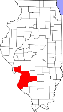 | |
|---|---|---|
| Major Cities (25,000+) | ||
| Cities (5,000-25,000) | ||
| Villages and Towns (1,000-5,000) |
| |
| Interstates in the Metro-East | ||
| Airports/Military Bases | ||
| List of Colleges in the Metro-East | ||
| Sports teams based in the Metro East |
| |
Municipalities and communities of St. Clair County, Illinois, United States | ||
|---|---|---|
| Cities | ||
| Villages | ||
| Townships | ||
| CDPs | ||
| Other unincorporated communities | ||
| Footnotes | ‡This populated place also has portions in an adjacent county or counties | |
| Counties | 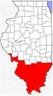 | |
|---|---|---|
| Mid-sized cities (25,000+) | ||
| Small Cities (10,000-25,000) | ||
| Small Cities (5,000-10,000) | ||
| Interstates | ||
| Airports/Military bases |
| |
| Universities | ||
| Colleges | ||
| Sports teams based in the Southern Illinois | ||