Greene County, Illinois
| Greene County, Illinois | |
|---|---|
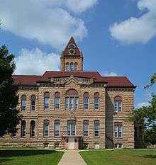 Greene County Courthouse | |
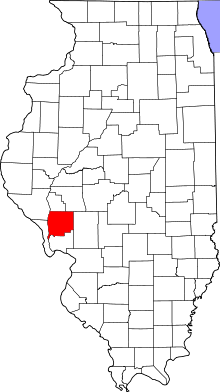 Location in the U.S. state of Illinois | |
 Illinois's location in the U.S. | |
| Founded | 1821 |
| Named for | Nathanael Greene |
| Seat | Carrollton |
| Largest city | White Hall |
| Area | |
| • Total | 546 sq mi (1,414 km2) |
| • Land | 543 sq mi (1,406 km2) |
| • Water | 3.3 sq mi (9 km2), 0.6% |
| Population | |
| • (2010) | 13,886 |
| • Density | 26/sq mi (10/km²) |
| Congressional district | 13th |
| Time zone | Central: UTC-6/-5 |
Greene County is a county located in the U.S. state of Illinois. According to the 2010 census, it has a population of 13,886.[1] Its county seat is Carrollton.[2]
It has a notable archaeological area known as the Koster Site, at which evidence of more than 7,000 years of human habitation has been excavated. Exhibits of artifacts from the site are displayed at the Center for American Archeology in Kampsville, Illinois.
History
Greene County is named in honor of General Nathanael Greene, a hero of the Revolutionary War.[3]
 Greene County from its creation in 1821 to 1823, including unorganized territory temporarily attached to it.[4]
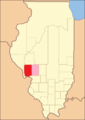 Greene County between 1823 and 1825
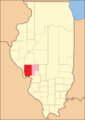 Greene between 1825 and 1829
 Greene between 1829 and 1839
 Greene in 1839, when the creation of Jersey County reduced it to its current size
Geography
According to the U.S. Census Bureau, the county has a total area of 546 square miles (1,410 km2), of which 543 square miles (1,410 km2) is land and 3.3 square miles (8.5 km2) (0.6%) is water.[5]
Climate and weather
| Carrollton, Illinois | ||||||||||||||||||||||||||||||||||||||||||||||||||||||||||||
|---|---|---|---|---|---|---|---|---|---|---|---|---|---|---|---|---|---|---|---|---|---|---|---|---|---|---|---|---|---|---|---|---|---|---|---|---|---|---|---|---|---|---|---|---|---|---|---|---|---|---|---|---|---|---|---|---|---|---|---|---|
| Climate chart (explanation) | ||||||||||||||||||||||||||||||||||||||||||||||||||||||||||||
| ||||||||||||||||||||||||||||||||||||||||||||||||||||||||||||
| ||||||||||||||||||||||||||||||||||||||||||||||||||||||||||||
In recent years, average temperatures in the county seat of Carrollton have ranged from a low of 16 °F (−9 °C) in January to a high of 87 °F (31 °C) in July, although a record low of −26 °F (−32 °C) was recorded in January 1912 and a record high of 113 °F (45 °C) was recorded in July 1934. Average monthly precipitation ranged from 1.60 inches (41 mm) in January to 4.34 inches (110 mm) in May.[6]
Major highways
Adjacent counties
- Scott County - north
- Morgan County - north
- Macoupin County - east
- Jersey County - south
- Calhoun County - southwest
- Pike County - northwest
National protected area
- Two Rivers National Wildlife Refuge (part: Apple Creek Division)
Demographics
| Historical population | |||
|---|---|---|---|
| Census | Pop. | %± | |
| 1830 | 7,674 | — | |
| 1840 | 11,951 | 55.7% | |
| 1850 | 12,429 | 4.0% | |
| 1860 | 16,093 | 29.5% | |
| 1870 | 20,277 | 26.0% | |
| 1880 | 23,010 | 13.5% | |
| 1890 | 23,791 | 3.4% | |
| 1900 | 23,402 | −1.6% | |
| 1910 | 22,363 | −4.4% | |
| 1920 | 22,883 | 2.3% | |
| 1930 | 20,417 | −10.8% | |
| 1940 | 20,292 | −0.6% | |
| 1950 | 18,852 | −7.1% | |
| 1960 | 17,460 | −7.4% | |
| 1970 | 17,014 | −2.6% | |
| 1980 | 16,661 | −2.1% | |
| 1990 | 15,317 | −8.1% | |
| 2000 | 14,761 | −3.6% | |
| 2010 | 13,886 | −5.9% | |
| Est. 2015 | 13,241 | [7] | −4.6% |
| U.S. Decennial Census[8] 1790-1960[9] 1900-1990[10] 1990-2000[11] 2010-2013[1] | |||
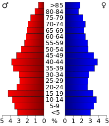
As of the 2010 United States Census, there were 13,886 people, 5,570 households, and 3,777 families residing in the county.[12] The population density was 25.6 inhabitants per square mile (9.9/km2). There were 6,389 housing units at an average density of 11.8 per square mile (4.6/km2).[5] The racial makeup of the county was 97.9% white, 0.9% black or African American, 0.2% American Indian, 0.1% Asian, 0.3% from other races, and 0.7% from two or more races. Those of Hispanic or Latino origin made up 0.8% of the population.[12] In terms of ancestry, 30.7% were German, 14.7% were Irish, 13.3% were English, and 12.1% were American.[13]
Of the 5,570 households, 30.9% had children under the age of 18 living with them, 53.0% were married couples living together, 9.4% had a female householder with no husband present, 32.2% were non-families, and 27.8% of all households were made up of individuals. The average household size was 2.44 and the average family size was 2.95. The median age was 41.6 years.[12]
The median income for a household in the county was $41,450 and the median income for a family was $52,049. Males had a median income of $38,185 versus $27,231 for females. The per capita income for the county was $22,107. About 11.8% of families and 15.1% of the population were below the poverty line, including 22.1% of those under age 18 and 10.0% of those age 65 or over.[14]
Communities
Cities
Villages
Unincorporated communities
- Barrow
- Belltown
- Berdan
- Drake (Hanks Station)
- East Hardin
- Lake Centralia
- Old Kane
Townships
See also
References
- 1 2 "State & County QuickFacts". United States Census Bureau. Retrieved July 5, 2014.
- ↑ "Find a County". National Association of Counties. Retrieved 2011-06-07.
- ↑ Gannett, Henry (1905). The Origin of Certain Place Names in the United States. Govt. Print. Off. p. 143.
- ↑ White, Jesse. Origin and Evolution of Illinois Counties. State of Illinois, March 2010.
- 1 2 "Population, Housing Units, Area, and Density: 2010 - County". United States Census Bureau. Retrieved 2015-07-11.
- 1 2 "Monthly Averages for Carrollton, Illinois". The Weather Channel. Retrieved 2011-01-27.
- ↑ "County Totals Dataset: Population, Population Change and Estimated Components of Population Change: April 1, 2010 to July 1, 2015". Retrieved July 2, 2016.
- ↑ "U.S. Decennial Census". United States Census Bureau. Retrieved July 5, 2014.
- ↑ "Historical Census Browser". University of Virginia Library. Retrieved July 5, 2014.
- ↑ "Population of Counties by Decennial Census: 1900 to 1990". United States Census Bureau. Retrieved July 5, 2014.
- ↑ "Census 2000 PHC-T-4. Ranking Tables for Counties: 1990 and 2000" (PDF). United States Census Bureau. Retrieved July 5, 2014.
- 1 2 3 "DP-1 Profile of General Population and Housing Characteristics: 2010 Demographic Profile Data". United States Census Bureau. Retrieved 2015-07-11.
- ↑ "DP02 SELECTED SOCIAL CHARACTERISTICS IN THE UNITED STATES – 2006-2010 American Community Survey 5-Year Estimates". United States Census Bureau. Retrieved 2015-07-11.
- ↑ "DP03 SELECTED ECONOMIC CHARACTERISTICS – 2006-2010 American Community Survey 5-Year Estimates". United States Census Bureau. Retrieved 2015-07-11.
 |
Pike County | Scott County and Morgan County | | |
| |
Macoupin County | |||
| ||||
| | ||||
| Calhoun County | Jersey County |
Municipalities and communities of Greene County, Illinois, United States | ||
|---|---|---|
| Cities | ||
| Villages | ||
| Townships | ||
| Unincorporated communities | ||

Coordinates: 39°21′N 90°23′W / 39.35°N 90.39°W