Interstate 57
| |||||||
|---|---|---|---|---|---|---|---|
 | |||||||
| Route information | |||||||
| Maintained by MoDOT and IDOT | |||||||
| Length: | 386.12 mi[1] (621.40 km) | ||||||
| Major junctions | |||||||
| South end: |
| ||||||
| |||||||
| North end: |
| ||||||
| Location | |||||||
| States: | Missouri, Illinois | ||||||
| Counties: |
MO: Scott, Mississippi | ||||||
| Highway system | |||||||
| |||||||

Interstate 57 (I-57) is an Interstate Highway in Missouri and Illinois that parallels the old Illinois Central rail line for much of its route. It goes from Sikeston, Missouri, at Interstate 55 to Chicago, Illinois, at Interstate 94. I-57 essentially serves as a shortcut route for travelers headed between the south (Memphis, New Orleans, etc.) and Chicago, bypassing St. Louis, Missouri. Between the junction of I-55 and I-57 in Sikeston, Missouri and the junction of I-55 and I-90/94 in Chicago, I-55 travels for 436 miles (702 km), while the combination of I-57 and I-94 is only 396 miles (637 km) long between the same two points. In fact, both the control cities on the overhead signs, as well as destination mileage signs, reference Memphis along southbound I-57, even as far north as its northern origin at I-94 in Chicago. Likewise, at its southern end, Chicago is the control city listed for I-57 on signs on northbound I-55 south of Sikeston, Missouri, even though I-55 also goes to Chicago.[2]
As of 2015, I-57 has no spur routes, nor are any planned in the nearby future. At a length of just over 386 miles (621 km), it is the second longest two-digit Interstate Highway without an auxiliary route, behind I-49. I-57 has one business loop in Charleston.
Route description
Missouri
In the state of Missouri, Interstate 57 runs northbound from Sikeston to the Cairo I-57 Bridge over the Mississippi River south of Cairo, Illinois.
After ending southbound at Interstate 55, the highway continues as U.S. Route 60, which meets U.S. Route 67 at Poplar Bluff, Missouri, and from there U.S. Route 67 goes south to Little Rock, Arkansas. The state of Missouri has proposed extending the I-57 designation down this corridor. However, this plan conflicts with Arkansas' plans to extend the Interstate 30 designation north on U.S. Route 67, a road of which a long section already meets Interstate Highway standards.
From the start of I-57 northbound, the US 60 concurrency goes about 12 miles (19 km).
Illinois
In the state of Illinois, Interstate 57 runs from the bridge over the Mississippi River north to Chicago. I-57 is the longest Interstate Highway in Illinois. Its route follows essentially the earlier route of US 51 in southernmost Illinois (US 51 has been diverted to I-57 where I-57 has always been close to old US 51 between Future City and Dongola) before taking a northeastward diagonal to Illinois 37, which remains intact as a town-to-town through route, past its interchange with Interstate 24 (the northwestern terminus of Interstate 24) near Pulleys Mill and a short duplex with Interstate 64 near Mount Vernon north to Effingham, where it has a short concurrence with Interstate 70. It then follows US 45 bypassing cities of Champaign and Urbana (where it meets Interstates 72 and 74), and heads north to Onarga whereafter it follows the formerly duplex path of US 45 and (now decommissioned in most of Illinois) old US 54 to Kankakee. At Kankakee it heads northward largely parallel to the now decommissioned route of old US 54 (since renumbered largely as Illinois 50) into greater Chicago, meeting Interstate 80 in Hazel Crest, Interstate 294 in Blue Island, and feeding Interstate 94 on Chicago's South Side.
Although I-57 serves as a long-distance bypass of St. Louis, the section between Mount Vernon and Pulleys Mill contains the most direct Interstate route between St. Louis and cities largely to the southeast of St. Louis (including Nashville and Atlanta). It serves as the northwestern terminus of Interstate 24 that leads southeastward to those cities and as the eastern terminus of Interstate 72 near Champaign.
The route is an easy way for Chicagoans to reach Shawnee National Forest in the southern tip of the state. It also serves as a major artery for college students in the state, running near Shawnee Community College in Ullin, Southern Illinois University in Carbondale, John A. Logan College in Carterville, Morthland College in West Frankfort, Rend Lake College in Ina, Lake Land College in Mattoon, Eastern Illinois University in Charleston, Parkland College in Champaign, University of Illinois at Urbana-Champaign in Urbana-Champaign, Kankakee Community College in Kankakee, Olivet Nazarene University in Bourbonnais, and Governors State University in University Park. Interstate 57 and Interstate 294 (Tri-State Tollway) did not have an intersection for a long time, though phase one finally opened on October 25, 2014.[3] It was one of only a few examples where Interstates cross but didn't have interchanges with each other. Vehicles were directed to use Interstate 80 to access Interstate 294 instead, though U.S. Route 6 was another option.
I-57 remains the only Chicago expressway that does not have a commonly used name. Its Chicago-area portion was formerly known as the Dan Ryan Expressway–West Leg. I-57 was named the Ken Gray Expressway in southern Illinois after former U.S. Congressman Ken Gray (West Frankfort) for his work on getting the route planned through southern Illinois. A 20-mile (32 km) segment from Wentworth to Sauk Trail has been designated the Tuskegee Airmen Memorial Trail[4] but this is not intended as a navigational name.
History
The portion between the Route 121/US 45 exit and the Watson–Mason exit was completed and opened prior to July 1965, linking I-57 to I-70, and running in tandem with I-70 for several miles, with access to Indianapolis to the east, and St. Louis to the west.
A 21.5-mile (34.6 km) section of I-57 in Jefferson County from Bonnie (using a temporary road that is still partially visible from the northbound lanes) to Route 161 opened on December 9, 1969.[5] The final section of I-57 in Illinois opened in December 1971 at Paxton.[6]
The portion of Interstate 43 from Milwaukee to Green Bay was originally numbered as Interstate 57.[7] The number was changed due to the existence of I-57 in Illinois.[8]
I-57 was widened to six lanes in Effingham from 2011 until 2015. The work is still under way on the north end at the bridge over US 45.[9]
Future
I-57 is slated to eventually be extended west along US 60 to Poplar Bluff, Missouri, and then south along the US 67 corridor to Little Rock, ending at I-40. In April 2016, a provision designating US 67 from North Little Rock to Walnut Ridge, Arkansas, as "Future I-57" was added into the federal fiscal year 2017 Transportation, Housing and Urban Development funding bill. The provision would also give Arkansas the ability to request any segment of the road built to Interstate Highway standards be officially added to the Interstate Highway System as I-57.[10] Missouri has already upgraded the 50 miles (80 km) of US 60 between Sikeston and Poplar Bluff, and 12 miles (19 km) of US 67 from Poplar Bluff to US 160 near Harviell (about 12 miles [19 km] north of the Arkansas state line) to four lanes with at-grade crossings, which would have to be eliminated before the Interstate designation could be applied.[11] In Arkansas, 118 miles (190 km) of Interstate-grade US 67 runs from I-40 to US 412 in Walnut Ridge.
The Illinois Department of Transportation (IDOT) has proposed widening a section of I-57 to six lanes of traffic from I-24 to I-64.[12] This section of Interstate has some of the highest annual average daily traffic on I-57 outside of the Chicago metropolitan area, with truck traffic amounting up to 30% of all traffic in spots.[13] This section of I-57 has been the site of several Interstate-closing accidents in the past 10 years, including an incident involving a train derailment over the Interstate near Benton in July 2004 and several fatal accidents in various construction zones.[14] The section in Mt. Vernon is due to be widened by 2013 with construction having begun in late 2011.[15]
IDOT and the Illinois State Toll Highway Authority are building an interchange at the junction of I-57 with I-294.[16] On October 25, 2014, the first phase of the interchange opened, providing access from I-57 north to I-294 north & from I-294 south to I-57 south. Phase one also provided access from I-294 south to 147th Street & 147th Street to I-294 north. Phase two will open in 2023/2024.
Exit list
| State | County | Location | mi[17][18] | km | Exit | Destinations | Notes | |
|---|---|---|---|---|---|---|---|---|
| Missouri | Scott | Sikeston | 0.000 | 0.000 | Continuation past I-55; southern end of US 60 concurrency | |||
| 0.169– 0.538 | 0.272– 0.866 | 1 | Current Southern terminus and signed as exits 1A (south) and 1B (north); I-55 exits 66A-B | |||||
| Mississippi | Long Prairie Township | 4.916 | 7.912 | 4 | ||||
| Charleston | 10.745 | 17.292 | 10 | |||||
| 13.027 | 20.965 | 12 | Northern end of US 60 concurrency | |||||
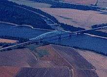
| Mississippi River | 22.328 0.00 | 35.933 0.00 | Interstate 57 Bridge Missouri–Illinois state line | |||||
| Illinois | Alexander | | 1.4 | 2.3 | 1 | Southern end of US 51 concurrency; southern terminus of IL 3 | ||
| Pulaski | | 7.6 | 12.2 | 8 | Mounds Road | |||
| | 17.7 | 28.5 | 18 | Ullin Road | ||||
| Union | | 24.4 | 39.3 | 24 | Dongola Road | |||
| | 25.0 | 40.2 | 25 | Northern end of US 51 concurrency; northbound exit and southbound entrance | ||||
| | 30.0 | 48.3 | 30 | |||||
| | 36.3 | 58.4 | 36 | Lick Creek Road | ||||
| Johnson | | 39.7 | 63.9 | 40 | Goreville Road | |||
| Williamson | Goreville | 43.9 | 70.7 | 44 | ||||
| | 45.2 | 72.7 | 45 | |||||
| Marion | 52.9 | 85.1 | 53 | Main Street -Marion | Former IL 13 | |||
| 53.6 | 86.3 | 54 | The Hill Avenue | IL 13 exit converted from cloverleaf interchange to single point urban interchange in 2013; northbound exit and southbound entrance for The Hill Avenue (formerly Morgan Avenue) also opened 2013;[19] signed as 54A (IL 13) and 54B (The Hill Avenue) northbound, exits combined southbound | ||||
| Johnston City | 58.9 | 94.8 | 59 | Johnston City, Herrin | ||||
| Franklin | West Frankfort | 64.6 | 104.0 | 65 | ||||
| Benton | 71.6 | 115.2 | 71 | |||||
| | 77.5 | 124.7 | 77 | |||||
| Jefferson | | 82.6 | 132.9 | 83 | Ina | |||
| | 91.5 | 147.3 | 92 | Southern end of I-64 concurrency; exit 78 on westbound I-64 | ||||
| Mt. Vernon | 93.7 | 150.8 | 94 | Veterans Memorial Drive | ||||
| | 94.7 | 152.4 | 95 | |||||
| | 96.2 | 154.8 | 96 | Northern end of I-64 concurrency; exit 73 on eastbound I-64 | ||||
| | 103.5 | 166.6 | 103 | Dix | ||||
| Marion | | 109.2 | 175.7 | 109 | ||||
| Salem | 116.4 | 187.3 | 116 | |||||
| | 127.2 | 204.7 | 127 | Kinmundy, Patoka | ||||
| Fayette | | 135.4 | 217.9 | 135 | ||||
| Clay |
No major junctions | |||||||
| Effingham | | 144.7 | 232.9 | 145 | Edgewood | |||
| | 150.7 | 242.5 | 151 | Mason, Watson | ||||
| | 157.3 | 253.1 | 157 | Southern end of I-70 concurrency; exit 92 on eastbound I-70 | ||||
| Effingham | 159.4 | 256.5 | 159 | Fayette Avenue | ||||
| 160.5 | 258.3 | 160 | ||||||
| | 162.2 | 261.0 | 162 | |||||
| | 163.4 | 263.0 | 163 | Northern end of I-70 concurrency; exit 98 on westbound I-70 | ||||
| Shelby |
No major junctions | |||||||
| Cumberland | | 177.0 | 284.9 | 177 | ||||
| Coles | Mattoon | 184.4 | 296.8 | 184 | ||||
| 189.6 | 305.1 | 190 | Signed as exits 190A (east) and 190B (west) | |||||
| 192.4 | 309.6 | 192 | CR 1000 north | |||||
| Douglas | Arcola | 203.6 | 327.7 | 203 | ||||
| | 211.7 | 340.7 | 212 | |||||
| Champaign | | 219.9 | 353.9 | 220 | ||||
| | 228.6 | 367.9 | 229 | Monticello, Savoy, Tolono | ||||
| | 231.7 | 372.9 | 232 | Curtis Road | ||||
| | 235.2 | 378.5 | 235 | University Avenue (via I-72 east) | Signed as 235A (University Avenue) and 235B (I-72 west); I-72 exits 182A-B | |||
| | 237.4 | 382.1 | 237 | Signed as exits 237A (east) and 237B (west); I-74 exits 179A-B. | ||||
| | 238.4 | 383.7 | 238 | Olympian Drive | ||||
| | 240.5 | 387.0 | 240 | Market Street | ||||
| | 250.2 | 402.7 | 250 | |||||
| Ford | Paxton | 260.9 | 419.9 | 261 | ||||
| Iroquois | | 271.9 | 437.6 | 272 | Buckley, Roberts | Roberts signed northbound only | ||
| | 279.9 | 450.5 | 280 | Roberts signed southbound only | ||||
| | 282.9 | 455.3 | 283 | |||||
| | 292.7 | 471.1 | 293 | |||||
| | 296.5 | 477.2 | 297 | Clifton | ||||
| | 301.6 | 485.4 | 302 | Chebanse | ||||
| Kankakee | | 307.5 | 494.9 | 308 | ||||
| Kankakee | 311.6 | 501.5 | 312 | |||||
| 315.3 | 507.4 | 315 | ||||||
| Manteno | 321.6 | 517.6 | 322 | Manteno | ||||
| Will | Peotone | 327.1 | 526.4 | 327 | Wilmington, Peotone | |||
| | 335.1 | 539.3 | 335 | Manhattan, Monee | ||||
| | 337 | Stuenkel Road, University Parkway | Access to Governors State University; interchange opened on October 30, 2015 | |||||
| Cook | Richton Park | 339.0 | 545.6 | 339 | Sauk Trail | |||
| Matteson | 340.69 | 548.29 | 340 | Signed as exits 340A (east) and 340B (west) southbound | ||||
| 342.21 | 550.73 | 342 | Vollmer Road | Signed as exits 342A (east) and 342B (west) southbound | ||||
| Oak Forest | 344.67– 344.86 | 554.69– 555.00 | 345 | Signed as exits 345A (east) & 345B (west); I-80 exits 151A-B. | ||||
| 346.62 | 557.83 | 346 | 167th Street | Cloverleaf with collector–distributor lanes | ||||
| Markham | 347.90 | 559.89 | 348 | Cloverleaf with collector–distributor lanes | ||||
| Blue Island | 349 | Northbound exit to northbound I-294 and southbound entrance from southbound I-294 only, opened 10-25-2014; complete interchange opening 2023–24; I-294 south exit 7. | ||||||
| Posen | 350.15 | 563.51 | 350 | |||||
| Calumet Park | 353.25 | 568.50 | 353 | 127th Street, Burr Oak Avenue (12700 South) | ||||
| Calumet Park–Chicago line | 354.25 | 570.11 | 354 | 119th Street | ||||
| Chicago | 355.27 | 571.75 | 355 | 111th Street, Monterey Avenue (11200 South) | ||||
| 357.32 | 575.05 | 357 | ||||||
| 358.47 | 576.90 | Wentworth Avenue (200 W) | No exit number; southbound exit only for traffic from EB I-94 | |||||
| 363.57– 364.12 | 585.11– 585.99 | — | Northbound exit & southbound entrance; northern terminus; I-94 exit 63. | |||||
1.000 mi = 1.609 km; 1.000 km = 0.621 mi
| ||||||||
In popular culture
- The Champaign band Braid recorded a song titled "Interstate 57" on their debut album, Frankie Welfare Boy Age Five.
- Carbondale pop punk band The Copyrights recorded a song titled "57 North" on their 4th album, Learn The Hard Way.
- Bill McAlister from Chicago has a band called "I-57 South" and recorded "I-57" on the album Illinois Opry. This song makes several references along the highway such as the cross in Effingham and Chambana.
See also
 Illinois portal
 Missouri portal
 U.S. Roads portal
References
- ↑ Staff (October 31, 2002). "Table 1: Main Routes of the Dwight D. Eisenhower National System of Interstate and Defense Highways as of October 31, 2002". Federal Highway Administration. Retrieved July 13, 2006.
- ↑ Staff. Exit 64A sign (Highway guide sign). Sikeston, MO: Missouri Department of Transportation. Retrieved April 4, 2012.
- ↑ Staff. "Proposed Tri-State Tollway I-294/I-57 Interchange". Illinois State Toll Highway Authority. Archived from the original on October 25, 2009. Retrieved April 4, 2012.
- ↑ "Stretch of Illinois highway named for Tuskegee Airmen". Retrieved September 25, 2014.
- ↑ Mt. Vernon Register-News. December 9, 1969. Missing or empty
|title=(help) - ↑ Southern Illinoisan. December 29, 1971. Missing or empty
|title=(help) - ↑ Fond du Lac Reporter. March 9, 1972. Missing or empty
|title=(help) - ↑ The Journal Times. Racine, WI. December 10, 1974. Missing or empty
|title=(help) - ↑ "Lochmueller Group I-57/I-70 Rehabilitation"..
- ↑ Office of John Boozman (April 25, 2016). "Boozman Provision in Appropriations Bill Paves Way for Interstate Status of US 67" (Press release). Office of John Boozman. Retrieved April 26, 2016.
- ↑ Heuring, Leonna (August 1, 2010). "MoDOT Celebrates Completion of US 60 Four-Lane Project with Caravan". The Southeast Missourian. Cape Girardeau, MO. Retrieved April 26, 2016.
- ↑ Illinois Department of Transportation. "Interstate 57 Add Lane from I-24 to I-64". Illinois Department of Transportation. Retrieved April 4, 2012.
- ↑ Illinois Department of Transportation. Map Viewer (Map). Illinois Department of Transportation. Retrieved April 4, 2012.
- ↑ Southern Illinoisan. Missing or empty
|title=(help) - ↑ Culli, Tesa (January 28, 2011). "Interstate 57 expanding to six lanes". Mt. Vernon Register-News. Retrieved April 4, 2012.
- ↑ Illinois Department of Transportation. "Welcome to the Interstate 57/294 Interchange Project Website!". Illinois Department of Transportation. Retrieved January 9, 2012.
- ↑ Missouri Department of Transportation (November 14, 2012). Flex Map Viewer (Map). Missouri Department of Transportation. Retrieved November 14, 2012.
- ↑ Google (2014-07-10). "Map of Interstate 57 in Illinois" (Map). Google Maps. Google. Retrieved 2014-07-10.
- ↑ "Governor Quinn Breaks Ground on $10.6 Million Widening Project for I-57 near Marion Illinois Jobs Now! Project Will Improve Key Southern Illinois Highway and Create Hundreds of Construction Jobs; $69 Million in Additional Projects Underway in Marion Area". Illinois Government News Network. Retrieved January 28, 2015.
External links
| Wikimedia Commons has media related to Interstate 57. |
| Signed | |||||||||||
|---|---|---|---|---|---|---|---|---|---|---|---|
| Unsigned | |||||||||||
| Lists |
| ||||||||||
Major Interstates highlighted | |||||||||||