Red Mountain (Ouray County, Colorado)
| Red Mountain Number 3 | |
|---|---|
 Red Mountain Number 3 | |
| Highest point | |
| Elevation | 12,896 ft (3,931 m) [1] |
| Coordinates | 37°54′06″N 107°41′21″W / 37.901662°N 107.6892276°WCoordinates: 37°54′06″N 107°41′21″W / 37.901662°N 107.6892276°W [2] |
| Geography | |
 Red Mountain Number 3 | |
| Location | Ouray and San Juan counties, Colorado, United States[2] |
| Parent range | San Juan Mountains |
| Topo map |
USGS 7.5' topographic map Ironton, Colorado[2] |
| Red Mountain Number 1 | |
|---|---|
 Red Mountain Number 1 | |
| Highest point | |
| Elevation | 12,598 ft (3,840 m) [3] |
| Coordinates | 37°54′37″N 107°39′44″W / 37.9102732°N 107.6622828°W [4] |
| Geography | |
| Location | Ouray and San Juan counties, Colorado, United States[4] |
| Red Mountain Number 2 | |
|---|---|
 Red Mountain Number 2 | |
| Highest point | |
| Elevation | 12,225 ft (3,726 m) [5] |
| Coordinates | 37°54′46″N 107°40′57″W / 37.9127730°N 107.6825607°W [6] |
| Geography | |
| Location | Ouray County, Colorado, U.S.[6] |
Red Mountain is a set of three peaks in the San Juan Mountains of western Colorado in the United States, about 5 miles south of Ouray. The mountains get their name from the reddish iron ore rocks that cover the surface. Several other peaks in the San Juan Mountains likewise have prominent reddish coloration from iron ore and are also called "Red Mountain".
Nearby Red Mountain Pass is named after Red Mountain, and the ghost town mining camp of Red Mountain Town is located at the foot of the Red Mountains.
Gallery
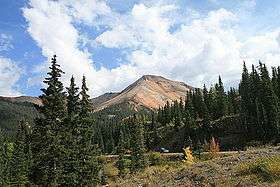
 Red Mountain Number 3 with the ghost town of Red Mountain.
 The San Juan Mountains as seen from Red Mountain Number 3
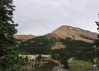
See also
- List of Colorado mountain ranges
- List of Colorado mountain summits
- List of Colorado county high points
References
- ↑ The elevation of Red Mountain Number 3 includes an adjustment of +1.801 m (+5.91 ft) from NGVD 29 to NAVD 88.
- 1 2 3 "Red Mountain Number 3". Geographic Names Information System. United States Geological Survey. Retrieved November 6, 2014.
- ↑ The elevation of Red Mountain Number 1 includes an adjustment of +1.826 m (+5.99 ft) from NGVD 29 to NAVD 88.
- 1 2 "Red Mountain Number 1". Geographic Names Information System. United States Geological Survey. Retrieved November 6, 2014.
- ↑ The elevation of Red Mountain Number 2 includes an adjustment of +1.803 m (+5.92 ft) from NGVD 29 to NAVD 88.
- 1 2 "Red Mountain Number 2". Geographic Names Information System. United States Geological Survey. Retrieved November 6, 2014.
External links
- Topographic map from USGS via Microsoft Research Maps

This article is issued from Wikipedia - version of the 12/28/2015. The text is available under the Creative Commons Attribution/Share Alike but additional terms may apply for the media files.