List of mountain ranges of Colorado

The following table lists the major mountain ranges of the U.S. State of Colorado. All of these ranges are all subranges of the Rocky Mountains.
Topographic elevation is the vertical distance above the reference geoid, a mathematical model of the Earth's sea level as an equipotential gravitational surface. The topographic prominence of a summit is the elevation difference between that summit and the highest or key col to a higher summit. The topographic isolation of a summit is the minimum great-circle distance to a point of equal elevation.
All elevations in this article include an elevation adjustment from the National Geodetic Vertical Datum of 1929 (NGVD 29) to the North American Vertical Datum of 1988 (NAVD 88). For further information, please see this United States National Geodetic Survey note.
If an elevation or prominence is calculated as a range of values, the arithmetic mean is shown.
Mountain ranges
| Mountain range | Highest summit | ||||||||
|---|---|---|---|---|---|---|---|---|---|
| primary | secondary | tertiary | Summit name | Elevation | Prominence | Isolation | |||
| rowspan=7 align=center | Sawatch Range[1][2] | rowspan=4 align=center | Central Sawatch Range | align=center | Elbert Massif[3] | Mount Elbert[4][5][6][7] | 14,440 ft 4401 m | 9,093 ft 2772 m | 671 mi 1,079 km |
| align=center | Massive Massif[8] | Mount Massive[9][10][11][12] | 14,428 ft 4398 m | 1,961 ft 598 m | 5.06 mi 8.14 km | ||||
| align=center | Collegiate Peaks[13] | Mount Harvard[14][15][16][17] | 14,421 ft 4396 m | 2,360 ft 719 m | 14.92 mi 24.0 km | ||||
| align=center | Williams Mountains[18] | Bill Williams Peak[19][20][21] | 13,389 ft 4081 m | 1,682 ft 513 m | 3.73 mi 6.00 km | ||||
| rowspan=2 align=center | Southern Sawatch Range[22] | Mount Antero[23][24][25][26] | 14,276 ft 4351 m | 2,503 ft 763 m | 17.67 mi 28.4 km | ||||
| align=center | Far Southern Sawatch Range[27] | Mount Ouray[28][29][30][31] | 13,961 ft 4255 m | 2,659 ft 810 m | 13.58 mi 21.9 km | ||||
| colspan=2 align=center | Northern Sawatch Range[32] | Mount of the Holy Cross[33][34][35][36][37] | 14,011 ft 4271 m | 2,111 ft 643 m | 18.41 mi 29.6 km | ||||
| rowspan=6 align=center | Sangre de Cristo Mountains[38] | colspan=2 align=center | Sierra Blanca Massif[39] | Blanca Peak[40][41][42] | 14,351 ft 4374 m | 5,326 ft 1623 m | 103.4 mi 166.4 km | ||
| rowspan=2 align=center | Northern Sangre de Cristo Range[43] | align=center | Crestones[44] | Crestone Peak[45][46][47] | 14,300 ft 4359 m | 4,554 ft 1388 m | 27.4 mi 44.0 km | ||
| Rito Alto Peak[48][49][50] | 13,803 ft 4207 m | 1,134 ft 346 m | 7.28 mi 11.71 km | ||||||
| rowspan=2 align=center | Culebra Range[51] | Culebra Peak[52][53][54] | 14,053 ft 4283 m | 4,827 ft 1471 m | 35.4 mi 56.9 km | ||||
| align=center | Spanish Peaks[55] | West Spanish Peak[56][57][58][59] | 13,631 ft 4155 m | 3,686 ft 1123 m | 20.5 mi 33.0 km | ||||
| colspan=2 align=center | Wet Mountains[60] | Greenhorn Mountain[61][62][63][64] | 12,352 ft 3765 m | 3,777 ft 1151 m | 25.2 mi 40.6 km | ||||
| rowspan=11 align=center | San Juan Mountains[65] | colspan=2 align=center | North Central San Juan Mountains[66] | Uncompahgre Peak[67][68][69][70] | 14,321 ft 4365 m | 4,277 ft 1304 m | 85.1 mi 136.9 km | ||
| colspan=2 align=center | San Miguel Mountains[71] | Mount Wilson[72][73][74] | 14,252 ft 4344 m | 4,024 ft 1227 m | 33.0 mi 53.1 km | ||||
| colspan=2 align=center | Sneffels Range[75] | Mount Sneffels[76][77][78][79] | 14,158 ft 4315 m | 3,050 ft 930 m | 15.71 mi 25.3 km | ||||
| rowspan=3 align=center | Needle Mountains[80] | Windom Peak[81][82][83][84] | 14,093 ft 4296 m | 2,187 ft 667 m | 26.3 mi 42.4 km | ||||
| align=center | Grenadier Range[85] | Vestal Peak[86][87][88] | 13,870 ft 4228 m | 1,124 ft 343 m | 4.29 mi 6.91 km | ||||
| align=center | West Needle Mountains[89] | Twilight Peak[90][91][92] | 13,163 ft 4012 m | 2,338 ft 713 m | 4.88 mi 7.86 km | ||||
| rowspan=2 align=center | La Garita Mountains[93] | San Luis Peak[94][95][96][97] | 14,022 ft 4274 m | 3,113 ft 949 m | 26.9 mi 43.4 km | ||||
| align=center | Cochetopa Hills | Long Branch Baldy[98][99][100][101] | 11,982 ft 3652 m | 1,454 ft 443 m | NA | ||||
| colspan=2 align=center | East Central San Juan Mountains[102] | Half Peak[103][104][105] | 13,848 ft 4221 m | 1,501 ft 458 m | 3.89 mi 6.26 km | ||||
| colspan=2 align=center | Southern San Juan Mountains[106] | Summit Peak[107][108][109][110][111] | 13,307 ft 4056 m | 2,760 ft 841 m | 39.6 mi 63.7 km | ||||
| colspan=2 align=center | La Plata Mountains[112] | Hesperus Mountain[113][114][115] | 13,237 ft 4035 m | 2,852 ft 869 m | 24.5 mi 39.5 km | ||||
| rowspan=2 align=center | Mosquito Range[116] | Mount Lincoln[117][118][119][120] | 14,293 ft 4357 m | 3,862 ft 1177 m | 22.5 mi 36.2 km | ||||
| colspan=2 align=center | Tenmile Range[121] | Quandary Peak[122][123][124][125] | 14,271 ft 4350 m | 1,125 ft 343 m | 3.16 mi 5.09 km | ||||
| rowspan=12 align=center | Front Range[126] | rowspan=2 align=center | Central Front Range[127] | Grays Peak[128][129][130][131] | 14,278 ft 4352 m | 2,770 ft 844 m | 25.0 mi 40.2 km | ||
| align=center | Chicago Peaks | Mount Evans[132][133][134][135] | 14,271 ft 4350 m | 2,769 ft 844 m | 9.79 mi 15.76 km | ||||
| rowspan=4 align=center | Northern Front Range[136] | align=center | Twin Peaks Massif[137] | Longs Peak[138][139][140][141] | 14,259 ft 4346 m | 2,940 ft 896 m | 43.6 mi 70.2 km | ||
| align=center | Mummy Range[142] | Hagues Peak[143][144][145][146] | 13,573 ft 4137 m | 2,420 ft 738 m | 15.70 mi 25.3 km | ||||
| align=center | Indian Peaks[147] | North Arapaho Peak[148][149][150][151] | 13,508 ft 4117 m | 1,665 ft 507 m | 15.38 mi 24.8 km | ||||
| align=center | Never Summer Mountains[152] | Mount Richthofen[153][154][155] | 12,945 ft 3946 m | 2,680 ft 817 m | 9.66 mi 15.54 km | ||||
| rowspan=6 align=center | Southern Front Range | align=center | Pikes Peak Massif | Pikes Peak[156][157][158][159][160] | 14,115 ft 4302 m | 5,530 ft 1686 m | 60.6 mi 97.6 km | ||
| align=center | South Williams Fork Mountains[161] | Ptarmigan Peak[162][163][164] | 12,504 ft 3811 m | 721 ft 220 m | 4.30 mi 6.92 km | ||||
| align=center | Kenosha Mountains[165] | Knobby Crest[166][167][168] | 12,434 ft 3790 m | 1,759 ft 536 m | 8.27 mi 13.31 km | ||||
| align=center | Tarryall Mountains[169] | Bison Peak[170][171][172][173] | 12,432 ft 3789 m | 2,451 ft 747 m | 18.23 mi 29.3 km | ||||
| align=center | South Park Hills[174] | Waugh Mountain[175][176][177] | 11,716 ft 3571 m | 2,330 ft 710 m | 18.86 mi 30.4 km | ||||
| align=center | Rampart Range[178] | Thunder Butte[179][180][181][182] | 9,837 ft 2998 m | 1,376 ft 419 m | 10.28 mi 16.54 km | ||||
| rowspan=3 align=center | Elk Mountains[183] | Castle Peak[184][185][186][187] | 14,279 ft 4352 m | 2,365 ft 721 m | 20.9 mi 33.6 km | ||||
| colspan=2 align=center | Ruby Range | Mount Owen[188][189][190][191] | 13,070 ft 3984 m | 1,358 ft 414 m | 7.39 mi 11.90 km | ||||
| colspan=2 align=center | West Elk Mountains[192] | West Elk Peak[193][194][195][196] | 13,042 ft 3975 m | 3,095 ft 943 m | 13.78 mi 22.2 km | ||||
| colspan=3 align=center | Gore Range[197] | Mount Powell[198][199][200] | 13,586 ft 4141 m | 3,000 ft 914 m | 21.5 mi 34.6 km | ||||
| colspan=3 align=center | Medicine Bow Mountains[201] | Clark Peak[202][203][204][205][206] | 12,960 ft 3950 m | 2,771 ft 845 m | 16.40 mi 26.4 km | ||||
| colspan=3 align=center | Flat Tops[207] | Flat Top Mountain[208][209][210][211] | 12,361 ft 3768 m | 4,054 ft 1236 m | 40.8 mi 65.6 km | ||||
| colspan=3 align=center | Rabbit Ears Range[212] | Parkview Mountain[213][214][215][216] | 12,301 ft 3749 m | 2,676 ft 816 m | 10.91 mi 17.56 km | ||||
| rowspan=2 align=center | Park Range[217] | colspan=2 align=center | Central Park Range[218] | Mount Zirkel[219][220][221] | 12,185 ft 3714 m | 3,470 ft 1058 m | 37.7 mi 60.6 km | ||
| colspan=2 align=center | Elkhead Mountains[222] | Sand Mountain North[223][224][225] | 10,884 ft 3317 m | 2,182 ft 665 m | 17.70 mi 28.5 km | ||||
| colspan=3 align=center | White River Plateau[226] | Blair Mountain[227][228][229] | 11,465 ft 3495 m | 1,736 ft 529 m | 11.50 mi 18.50 km | ||||
| colspan=3 align=center | Grand Mesa[230] | Crater Peak[231][232][233][234] | 11,333 ft 3454 m | 2,307 ft 703 m | 17.98 mi 28.9 km | ||||
| colspan=3 align=center | Laramie Mountains[235] | South Bald Mountain[236][237][238][239][240] | 11,009 ft 3356 m | 1,863 ft 568 m | 8.54 mi 13.74 km | ||||
| colspan=3 align=center | Uncompaghre Plateau[241] | Horsefly Peak[242][243][244][245] | 10,353 ft 3156 m | 1,437 ft 438 m | 13.04 mi 21.0 km | ||||
| colspan=3 align=center | Ute Mountain[246] | Ute Peak[247][248][249][250] | 9,984 ft 3043 m | 4,039 ft 1231 m | 34.3 mi 55.2 km | ||||
| colspan=3 align=center | Raton Mesa[251] | Fishers Peak[252][253][254][255][256] | 9,633 ft 2936 m | 1,847 ft 563 m | 31.0 mi 49.9 km | ||||
Gallery

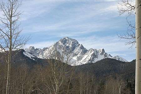
_-_2006-07-16.jpg) Mount Harvard is the highest of the Collegiate Peaks and the third highest peak of the Rocky Mountains.
Mount Harvard is the highest of the Collegiate Peaks and the third highest peak of the Rocky Mountains.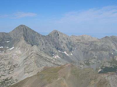 Blanca Peak is the highest peak of the Sangre de Cristo Mountains and the fifth highest peak of the Rocky Mountains.
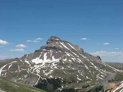 Uncompahgre Peak is the highest peak of the San Juan Mountains and the sixth highest peak of the Rocky Mountains.
 Crestone Peak is the highest peak of the Crestones and the seventh highest peak of the Rocky Mountains.
 Mount Lincoln is the highest peak of the Mosquito Range and the eighth highest peak of the Rocky Mountains.
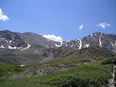 Grays Peak is the highest peak of the Front Range and the tenth highest peak of the Rocky Mountains.


 Pikes Peak is the highest peak of the Southern Front Range. The mountain was the inspiration for America the Beautiful.
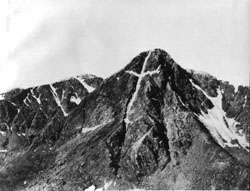 Mount of the Holy Cross is the highest peak of the Northern Sawatch Range. This photograph was taken by William Henry Jackson in 1874.
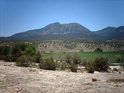

See also
- List of mountain peaks of North America
- List of mountain peaks of Greenland
- List of mountain peaks of Canada
- List of mountain peaks of the Rocky Mountains
- List of mountain peaks of the United States
- List of mountain peaks of México
- List of mountain peaks of Central America
- List of mountain peaks of the Caribbean
- Colorado
- Geography of Colorado
- Category:Mountains of Colorado
- Geography of Colorado
- Physical geography
References
- ↑ "Sawatch Range". Mountain Ranges of the World. peakbagger.com. Retrieved September 26, 2014.
- ↑ The place name "Sawatch" is pronounced /səˈwætʃ/. This name derives from the Ute language noun "sawup" /səˈwʌp/ meaning "sand dunes". The Spanish language version of this name is usually spelled "Saguache", while the English language version is usually spelled "Sawatch"
- ↑ "Elbert Massif". Mountain Ranges of the World. peakbagger.com. Retrieved March 9, 2012.
- ↑ The summit of Mount Elbert is the highest point of the Rocky Mountains, the State of Colorado, and Lake County.
- ↑ "Mount Elbert". Datasheet for NGS Station KL0637. United States National Geodetic Survey. Retrieved September 23, 2014.
- ↑ The elevation of Mount Elbert includes an adjustment of +1.995 m (+6.55 ft) from NGVD 29 to NAVD 88.
- ↑ "Mount Elbert". Peakbagger.com. Retrieved September 23, 2014.
- ↑ "Massive Massif". Mountain Ranges of the World. peakbagger.com. Retrieved March 9, 2012.
- ↑ Mount Massive is the second highest peak of the Rocky Mountains..
- ↑ "Mount Massive". Datasheet for NGS Station KL0640. United States National Geodetic Survey. Retrieved September 24, 2014.
- ↑ The elevation of Mount Massive includes an adjustment of +2.087 m (+6.85 ft) from NGVD 29 to NAVD 88.
- ↑ "Mount Massive". Peakbagger.com. Retrieved September 24, 2014.
- ↑ "Collegiate Peaks". Mountain Ranges of the World. peakbagger.com. Retrieved March 9, 2012.
- ↑ The summit of Mount Harvard is the highest point of the Collegiate Peaks and Chaffee County, Colorado.
- ↑ "Mount Harvard". Datasheet for NGS Station JL0879. United States National Geodetic Survey. Retrieved September 23, 2014.
- ↑ The elevation of Mount Harvard includes an adjustment of +2.084 m (+6.84 ft) from NGVD 29 to NAVD 88.
- ↑ "Mount Harvard". Peakbagger.com. Retrieved September 23, 2014.
- ↑ "Williams Mountains". Mountain Ranges of the World. peakbagger.com. Retrieved March 9, 2012.
- ↑ The summit of Bill Williams Peak is the highest point of the Williams Mountains.
- ↑ The elevation of Bill Williams Peak includes an adjustment of +2.044 m (+6.71 ft) from NGVD 29 to NAVD 88.
- ↑ "Bill Williams Peak". Peakbagger.com. Retrieved September 24, 2014.
- ↑ "Southern Sawatch Range". Mountain Ranges of the World. peakbagger.com. Retrieved March 9, 2012.
- ↑ The summit of Mount Antero is the highest point of the southern Sawatch Range.
- ↑ "Mount Antero". Datasheet for NGS Station JL0883. United States National Geodetic Survey. Retrieved September 23, 2014.
- ↑ The elevation of Mount Antero includes an adjustment of +2.071 m (+6.79 ft) from NGVD 29 to NAVD 88.
- ↑ "Mount Antero". Peakbagger.com. Retrieved September 23, 2014.
- ↑ "Far Southern Sawatch Range". Mountain Ranges of the World. peakbagger.com. Retrieved March 9, 2012.
- ↑ The summit of Mount Ouray is the highest point of the far southern Sawatch Range.
- ↑ "Mount Ouray". Datasheet for NGS Station JL0672. United States National Geodetic Survey. Retrieved September 23, 2014.
- ↑ The elevation of Mount Ouray includes an adjustment of +1.871 m (+6.14 ft) from NGVD 29 to NAVD 88.
- ↑ "Mount Ouray". Peakbagger.com. Retrieved September 23, 2014.
- ↑ "Northern Sawatch Range". Mountain Ranges of the World. peakbagger.com. Retrieved March 9, 2012.
- ↑ The summit of Mount of the Holy Cross is the highest point of the northern Sawatch Range and Eagle County, Colorado.
- ↑ "MT HOLY CROSS ET". Datasheet for NGS Station KL0649. United States National Geodetic Survey. Retrieved October 7, 2014.
- ↑ The summit elevation of Mount of the Holy Cross includes a vertical offset of +0.61 m (+2.0 ft) from the station benchmark.
- ↑ The elevation of Mount of the Holy Cross includes an adjustment of +1.926 m (+6.32 ft) from NGVD 29 to NAVD 88.
- ↑ "Mount of the Holy Cross". Peakbagger.com. Retrieved October 7, 2014.
- ↑ "Sangre de Cristo Mountains". Mountain Ranges of the World. peakbagger.com. Retrieved March 9, 2012.
- ↑ "Sierra Blanca Massif". Mountain Ranges of the World. peakbagger.com. Retrieved March 9, 2012.
- ↑ The summit of Blanca Peak is the highest point of the Sierra Blanca Massif, the Sangre de Cristo Mountains, Alamosa County and Costilla County, Colorado.
- ↑ The elevation of Blanca Peak includes an adjustment of +1.755 m (+5.76 ft) from NGVD 29 to NAVD 88.
- ↑ "Blanca Peak". Peakbagger.com. Retrieved September 23, 2014.
- ↑ "Northern Sangre de Cristo Range". Mountain Ranges of the World. peakbagger.com. Retrieved March 9, 2012.
- ↑ "Crestones". Mountain Ranges of the World. peakbagger.com. Retrieved March 9, 2012.
- ↑ The summit of Crestone Peak is the highest point of the northern Sangre de Cristo Mountains and Saguache County, Colorado.
- ↑ The elevation of Crestone Peak includes an adjustment of +1.760 m (+5.77 ft) from NGVD 29 to NAVD 88.
- ↑ "Crestone Peak". Peakbagger.com. Retrieved September 23, 2014.
- ↑ "Rito Alto Peak". Datasheet for NGS Station JK1300. United States National Geodetic Survey. Retrieved September 29, 2014.
- ↑ The elevation of Rito Alto Peak includes an adjustment of +1.808 m (+5.93 ft) from NGVD 29 to NAVD 88.
- ↑ "Rito Alto Peak". Peakbagger.com. Retrieved September 29, 2014.
- ↑ "Culebra Range". Mountain Ranges of the World. peakbagger.com. Retrieved March 9, 2012.
- ↑ The summit of Culebra Peak is the highest point of the Culebra Range.
- ↑ The elevation of Culebra Peak includes an adjustment of +1.740 m (+5.71 ft) from NGVD 29 to NAVD 88.
- ↑ "Culebra Peak". Peakbagger.com. Retrieved September 23, 2014.
- ↑ "Spanish Peaks". Mountain Ranges of the World. peakbagger.com. Retrieved March 9, 2012.
- ↑ The summit of West Spanish Peak is the highest point of Las Animas County, Colorado.
- ↑ West Spanish Peak is the easternmost 13,000-foot (4,000 m) summit of the United States..
- ↑ The elevation of West Spanish Peak includes an adjustment of +1.468 m (+4.82 ft) from NGVD 29 to NAVD 88.
- ↑ "West Spanish Peak". Peakbagger.com. Retrieved September 24, 2014.
- ↑ "Wet Mountains". Mountain Ranges of the World. peakbagger.com. Retrieved March 9, 2012.
- ↑ The summit of Greenhorn Mountain is the highest point of the Wet Mountains and Pueblo County, Colorado.
- ↑ "Greenhorn Mountain". Datasheet for NGS Station HK0512. United States National Geodetic Survey. Retrieved September 23, 2014.
- ↑ The elevation of Greenhorn Mountain includes an adjustment of +1.401 m (+4.60 ft) from NGVD 29 to NAVD 88.
- ↑ "Greenhorn Mountain". Peakbagger.com. Retrieved September 23, 2014.
- ↑ "San Juan Mountains". Mountain Ranges of the World. peakbagger.com. Retrieved March 9, 2012.
- ↑ "North Central San Juan Mountains". Mountain Ranges of the World. peakbagger.com. Retrieved March 9, 2012.
- ↑ The summit of Uncompahgre Peak is the highest point of the San Juan Mountains and Hinsdale County, Colorado.
- ↑ "Uncompahgre Peak". Datasheet for NGS Station JL0798. United States National Geodetic Survey. Retrieved September 23, 2014.
- ↑ The elevation of Uncompahgre Peak includes an adjustment of +1.967 m (+6.45 ft) from NGVD 29 to NAVD 88.
- ↑ "Uncompahgre Peak". Peakbagger.com. Retrieved September 23, 2014.
- ↑ "San Miguel Mountains". Mountain Ranges of the World. peakbagger.com. Retrieved March 9, 2012.
- ↑ The summit of Mount Wilson is the highest point of the San Miguel Mountains and Dolores County, Colorado.
- ↑ The elevation of Mount Wilson includes an adjustment of +1.899 m (+6.23 ft) from NGVD 29 to NAVD 88.
- ↑ "Mount Wilson". Peakbagger.com. Retrieved September 23, 2014.
- ↑ "Sneffels Range". Mountain Ranges of the World. peakbagger.com. Retrieved March 9, 2012.
- ↑ The summit of Mount Sneffels is the highest point of the Sneffels Range and Ouray County, Colorado.
- ↑ "Mount Sneffels". Datasheet for NGS Station JL0826. United States National Geodetic Survey. Retrieved September 23, 2014.
- ↑ The elevation of Mount Sneffels includes an adjustment of +1.879 m (+6.16 ft) from NGVD 29 to NAVD 88.
- ↑ "Mount Sneffels". Peakbagger.com. Retrieved September 23, 2014.
- ↑ "Needle Mountains". Mountain Ranges of the World. peakbagger.com. Retrieved March 9, 2012.
- ↑ The summit of Windom Peak is the highest point of the Needle Mountains and La Plata County, Colorado.
- ↑ Mount Eolus may be higher than Windom Peak..
- ↑ The elevation of Windom Peak includes an adjustment of +1.785 m (+5.86 ft) from NGVD 29 to NAVD 88.
- ↑ "Windom Peak". Peakbagger.com. Retrieved September 25, 2014.
- ↑ "Grenadier Range". Mountain Ranges of the World. peakbagger.com. Retrieved March 9, 2012.
- ↑ The summit of Vestal Peak is the highest point of the Grenadier Range.
- ↑ The elevation of Vestal Peak includes an adjustment of +1.781 m (+5.84 ft) from NGVD 29 to NAVD 88.
- ↑ "Vestal Peak". Peakbagger.com. Retrieved September 26, 2014.
- ↑ "West Needle Mountains". Mountain Ranges of the World. peakbagger.com. Retrieved March 9, 2012.
- ↑ The summit of Twilight Peak is the highest point of the West Needle Mountains.
- ↑ The elevation of Twilight Peak includes an adjustment of +1.537 m (+5.04 ft) from NGVD 29 to NAVD 88.
- ↑ "Twilight Peak". Peakbagger.com. Retrieved September 24, 2014.
- ↑ "La Garita Mountains". Mountain Ranges of the World. peakbagger.com. Retrieved March 9, 2012.
- ↑ The summit of San Luis Peak is the highest point of the La Garita Mountains.
- ↑ "San Luis Peak". Datasheet for NGS Station HL0570. United States National Geodetic Survey. Retrieved September 23, 2014.
- ↑ The elevation of San Luis Peak includes an adjustment of +2.098 m (+6.88 ft) from NGVD 29 to NAVD 88.
- ↑ "San Luis Peak". Peakbagger.com. Retrieved September 23, 2014.
- ↑ The summit of Long Branch Baldy is the highest point of the Cochetopa Hills.
- ↑ "Long Branch Baldy". Datasheet for NGS Station JL0682. United States National Geodetic Survey. Retrieved September 26, 2014.
- ↑ The elevation of Long Branch Baldy includes an adjustment of +1.860 m (+6.10 ft) from NGVD 29 to NAVD 88.
- ↑ "Long Branch Baldy". Peakbagger.com. Retrieved September 26, 2014.
- ↑ "East Central San Juan Mountains". Mountain Ranges of the World. peakbagger.com. Retrieved March 9, 2012.
- ↑ The summit of Half Peak is the highest point of the east central San Juan Mountains.
- ↑ The elevation of Half Peak includes an adjustment of +1.998 m (+6.56 ft) from NGVD 29 to NAVD 88.
- ↑ "Half Peak". Peakbagger.com. Retrieved September 26, 2014.
- ↑ "Southern San Juan Mountains". Mountain Ranges of the World. peakbagger.com. Retrieved March 9, 2012.
- ↑ The summit of Summit Peak is the highest point of the southern San Juan Mountains and Archuleta County, Colorado.
- ↑ "SUMMIT". Datasheet for NGS Station HL0503. United States National Geodetic Survey. Retrieved October 7, 2014.
- ↑ The summit elevation of Summit Peak includes a vertical offset of -0.15 m (−0.5 ft) from the station benchmark.
- ↑ The elevation of Summit Peak includes an adjustment of +1.877 m (+6.16 ft) from NGVD 29 to NAVD 88.
- ↑ "Summit Peak". Peakbagger.com. Retrieved October 7, 2014.
- ↑ "La Plata Mountains". Mountain Ranges of the World. peakbagger.com. Retrieved March 9, 2012.
- ↑ The summit of Hesperus Mountain is the highest point of the La Plata Mountains and Montezuma County, Colorado.
- ↑ The elevation of Hesperus Mountain includes an adjustment of +1.650 m (+5.41 ft) from NGVD 29 to NAVD 88.
- ↑ "Hesperus Mountain". Peakbagger.com. Retrieved September 23, 2014.
- ↑ "Mosquito Range". Mountain Ranges of the World. peakbagger.com.
- ↑ The summit of Mount Lincoln is the highest point of the Mosquito Range and Park County, Colorado.
- ↑ "Mount Lincoln". Datasheet for NGS Station KL0627. United States National Geodetic Survey. Retrieved September 23, 2014.
- ↑ The elevation of Mount Lincoln includes an adjustment of +2.098 m (+6.88 ft) from NGVD 29 to NAVD 88.
- ↑ "Mount Lincoln". Peakbagger.com. Retrieved September 23, 2014.
- ↑ "Tenmile Range". Mountain Ranges of the World. peakbagger.com. Retrieved March 9, 2012.
- ↑ The summit of Quandary Peak is the highest point of the Tenmile Range.
- ↑ "Quandary Peak". Datasheet for NGS Station KL0622. United States National Geodetic Survey. Retrieved September 25, 2014.
- ↑ The elevation of Quandary Peak includes an adjustment of +2.071 m (+6.79 ft) from NGVD 29 to NAVD 88.
- ↑ "Quandary Peak". Peakbagger.com. Retrieved September 25, 2014.
- ↑ "Front Range". Mountain Ranges of the World. peakbagger.com. Retrieved March 9, 2012.
- ↑ "Central Front Range". Mountain Ranges of the World. peakbagger.com. Retrieved March 9, 2012.
- ↑ The summit of Grays Peak is the highest point of the Front Range, the Continental Divide of North America, Clear Creek County and Summit County, Colorado.
- ↑ "Grays Peak". Datasheet for NGS Station KK2036. United States National Geodetic Survey. Retrieved September 24, 2014.
- ↑ The elevation of Grays Peak includes an adjustment of +1.881 m (+6.17 ft) from NGVD 29 to NAVD 88.
- ↑ "Grays Peak". Peakbagger.com. Retrieved September 24, 2014.
- ↑ "EVANS". Datasheet for NGS Station KK2030. United States National Geodetic Survey. Retrieved October 7, 2014.
- ↑ The summit elevation of Mount Evans includes a vertical offset of +1.80 m (+5.9 ft) from the station benchmark.
- ↑ The elevation of Mount Evans includes an adjustment of +1.827 m (+5.99 ft) from NGVD 29 to NAVD 88.
- ↑ "Mount Evans". Peakbagger.com. Retrieved October 7, 2014.
- ↑ "Northern Front Range". Mountain Ranges of the World. peakbagger.com. Retrieved March 9, 2012.
- ↑ "Twin Peaks Massif". Mountain Ranges of the World. peakbagger.com. Retrieved March 9, 2012.
- ↑ The summit of Longs Peak is the highest point of the northern Front Range, Rocky Mountain National Park, and Boulder County, Colorado.
- ↑ "Longs Peak". Datasheet for NGS Station LL1346. United States National Geodetic Survey. Retrieved September 23, 2014.
- ↑ The elevation of Longs Peak includes an adjustment of +1.652 m (+5.42 ft) from NGVD 29 to NAVD 88.
- ↑ "Longs Peak". Peakbagger.com. Retrieved September 23, 2014.
- ↑ "Mummy Range". Mountain Ranges of the World. peakbagger.com. Retrieved March 9, 2012.
- ↑ The summit of Hagues Peak is the highest point of the Mummy Range and Larimer County, Colorado.
- ↑ "Hagues Peak". Datasheet for NGS Station LL1350. United States National Geodetic Survey. Retrieved September 23, 2014.
- ↑ The elevation of Hagues Peak includes an adjustment of +1.719 m (+5.64 ft) from NGVD 29 to NAVD 88.
- ↑ "Hagues Peak". Peakbagger.com. Retrieved September 23, 2014.
- ↑ "Indian Peaks". Mountain Ranges of the World. peakbagger.com. Retrieved March 9, 2012.
- ↑ The summit of North Arapaho Peak is the highest point of the Indian Peaks.
- ↑ "North Arapaho Peak". Datasheet for NGS Station LL1357. United States National Geodetic Survey. Retrieved September 23, 2014.
- ↑ The elevation of North Arapaho Peak includes an adjustment of +1.763 m (+5.78 ft) from NGVD 29 to NAVD 88.
- ↑ "North Arapaho Peak". Peakbagger.com. Retrieved September 23, 2014.
- ↑ "Never Summer Mountains". Mountain Ranges of the World. peakbagger.com. Retrieved March 9, 2012.
- ↑ The summit of Mount Richthofen is the highest point of the Never Summer Mountains.
- ↑ The elevation of Mount Richthofen includes an adjustment of +1.658 m (+5.44 ft) from NGVD 29 to NAVD 88.
- ↑ "Mount Richthofen". Peakbagger.com. Retrieved September 24, 2014.
- ↑ The summit of Pikes Peak is the highest point of the southern Front Range and El Paso County, Colorado.
- ↑ Pikes Peak is the easternmost 14,000-foot (4,300 m) summit of the United States. Pikes Peak was the inspiration for the lyrics of America the Beautiful..
- ↑ "Pikes Peak". Datasheet for NGS Station JK1242. United States National Geodetic Survey. Retrieved September 23, 2014.
- ↑ The elevation of Pikes Peak includes an adjustment of +1.678 m (+5.51 ft) from NGVD 29 to NAVD 88.
- ↑ "Pikes Peak". Peakbagger.com. Retrieved September 23, 2014.
- ↑ "South Williams Fork Mountains". Mountain Ranges of the World. peakbagger.com. Retrieved March 9, 2012.
- ↑ The summit of Ptarmigan Peak is the highest point of the South Williams Fork Mountains.
- ↑ The elevation of Ptarmigan Peak includes an adjustment of +1.789 m (+5.87 ft) from NGVD 29 to NAVD 88.
- ↑ "Ptarmigan Peak". Peakbagger.com. Retrieved September 26, 2014.
- ↑ "Kenosha Mountains". Mountain Ranges of the World. peakbagger.com. Retrieved March 9, 2012.
- ↑ The summit of Knobby Crest is the highest point of the Kenosha Mountains.
- ↑ The elevation of Knobby Crest includes an adjustment of +1.595 m (+5.23 ft) from NGVD 29 to NAVD 88.
- ↑ "Knobby Crest". Peakbagger.com. Retrieved September 24, 2014.
- ↑ "Tarryall Mountains". Mountain Ranges of the World. peakbagger.com. Retrieved March 9, 2012.
- ↑ The summit of Bison Peak is the highest point of the Tarryall Mountains.
- ↑ "Bison Peak". Datasheet for NGS Station KK1966. United States National Geodetic Survey. Retrieved September 24, 2014.
- ↑ The elevation of Bison Peak includes an adjustment of +1.623 m (+5.32 ft) from NGVD 29 to NAVD 88.
- ↑ "Bison Peak". Peakbagger.com. Retrieved September 24, 2014.
- ↑ "South Park Hills". Mountain Ranges of the World. peakbagger.com. Retrieved March 9, 2012.
- ↑ The summit of Waugh Mountain is the highest point of the South Park Hills.
- ↑ The elevation of Waugh Mountain includes an adjustment of +1.702 m (+5.58 ft) from NGVD 29 to NAVD 88.
- ↑ "Waugh Mountain". Peakbagger.com. Retrieved September 24, 2014.
- ↑ "Rampart Range". Mountain Ranges of the World. peakbagger.com. Retrieved March 9, 2012.
- ↑ The summit of Thunder Butte is the highest point of Douglas County, Colorado.
- ↑ "Thunder Butte". Datasheet for NGS Station KK1953. United States National Geodetic Survey. Retrieved September 23, 2014.
- ↑ The elevation of Thunder Butte includes an adjustment of +1.216 m (+3.99 ft) from NGVD 29 to NAVD 88.
- ↑ "Thunder Butte". Peakbagger.com. Retrieved September 23, 2014.
- ↑ "Elk Mountains". Mountain Ranges of the World. peakbagger.com. Retrieved March 9, 2012.
- ↑ The summit of Castle Peak is the highest point of the Elk Mountains, Gunnison County and Pitkin County, Colorado.
- ↑ "Castle Peak". Datasheet for NGS Station KL0659. United States National Geodetic Survey. Retrieved September 23, 2014.
- ↑ The elevation of Castle Peak includes an adjustment of +2.165 m (+7.10 ft) from NGVD 29 to NAVD 88.
- ↑ "Castle Peak". Peakbagger.com. Retrieved September 23, 2014.
- ↑ The summit of Mount Owen is the highest point of the Ruby Range.
- ↑ "Mount Owen". Datasheet for NGS Station JL0737. United States National Geodetic Survey. Retrieved September 26, 2014.
- ↑ The elevation of Mount Owen includes an adjustment of +1.990 m (+6.53 ft) from NGVD 29 to NAVD 88.
- ↑ "Mount Owen". Peakbagger.com. Retrieved September 26, 2014.
- ↑ "West Elk Mountains". Mountain Ranges of the World. peakbagger.com. Retrieved March 9, 2012.
- ↑ The summit of West Elk Peak is the highest point of the West Elk Mountains.
- ↑ "West Elk Peak". Datasheet for NGS Station JL0755. United States National Geodetic Survey. Retrieved September 24, 2014.
- ↑ The elevation of West Elk Peak includes an adjustment of +2.105 m (+6.91 ft) from NGVD 29 to NAVD 88.
- ↑ "West Elk Peak". Peakbagger.com. Retrieved September 24, 2014.
- ↑ "Gore Range". Mountain Ranges of the World. peakbagger.com. Retrieved March 9, 2012.
- ↑ The summit of Mount Powell is the highest point of the Gore Range.
- ↑ The elevation of Mount Powell includes an adjustment of +1.771 m (+5.81 ft) from NGVD 29 to NAVD 88.
- ↑ "Mount Powell". Peakbagger.com. Retrieved September 24, 2014.
- ↑ "Medicine Bow Mountains". Mountain Ranges of the World. peakbagger.com. Retrieved March 9, 2012.
- ↑ The summit of Clark Peak is the highest point of the Medicine Bow Mountains and Jackson County, Colorado.
- ↑ "CLARK". Datasheet for NGS Station LL1388. United States National Geodetic Survey. Retrieved October 7, 2014.
- ↑ The summit elevation of Clark Peak includes a vertical offset of +1.83 m (+6.0 ft) from the station benchmark.
- ↑ The elevation of Clark Peak includes an adjustment of +1.628 m (+5.34 ft) from NGVD 29 to NAVD 88.
- ↑ "Clark Peak". Peakbagger.com. Retrieved October 7, 2014.
- ↑ "Flat Tops". Mountain Ranges of the World. peakbagger.com. Retrieved September 26, 2014.
- ↑ The summit of Flat Top Mountain is the highest point of the Flat Tops and Garfield County, Colorado.
- ↑ "Flat Top Mountain". Datasheet for NGS Station LM0694. United States National Geodetic Survey. Retrieved September 24, 2014.
- ↑ The elevation of Flat Top Mountain includes an adjustment of +1.698 m (+5.57 ft) from NGVD 29 to NAVD 88.
- ↑ "Flat Top Mountain". Peakbagger.com. Retrieved September 24, 2014.
- ↑ "Rabbit Ears Range". Mountain Ranges of the World. peakbagger.com. Retrieved March 9, 2012.
- ↑ The summit of Parkview Mountain is the highest point of the Rabbit Ears Range.
- ↑ "Parkview Mountain". Datasheet for NGS Station LM0574. United States National Geodetic Survey. Retrieved September 24, 2014.
- ↑ The elevation of Parkview Mountain includes an adjustment of +1.589 m (+5.21 ft) from NGVD 29 to NAVD 88.
- ↑ "Parkview Mountain". Peakbagger.com. Retrieved September 24, 2014.
- ↑ "Park Range". Mountain Ranges of the World. peakbagger.com. Retrieved March 9, 2012.
- ↑ "Central Park Range". Mountain Ranges of the World. peakbagger.com. Retrieved March 9, 2012.
- ↑ The summit of Mount Zirkel is the highest point of the Park Range and Routt County, Colorado.
- ↑ The elevation of Mount Zirkel includes an adjustment of +1.632 m (+5.35 ft) from NGVD 29 to NAVD 88.
- ↑ "Mount Zirkel". Peakbagger.com. Retrieved September 23, 2014.
- ↑ "Elkhead Mountains". Mountain Ranges of the World. peakbagger.com. Retrieved March 9, 2012.
- ↑ The summit of Sand Mountain North is the highest point of the Elkhead Mountains.
- ↑ The elevation of Sand Mountain North includes an adjustment of +1.502 m (+4.93 ft) from NGVD 29 to NAVD 88.
- ↑ "Sand Mountain North". Peakbagger.com. Retrieved September 24, 2014.
- ↑ "White River Plateau". Mountain Ranges of the World. peakbagger.com. Retrieved March 9, 2012.
- ↑ The summit of Blair Mountain is the highest point of the White River Plateau.
- ↑ The elevation of Blair Mountain includes an adjustment of +1.565 m (+5.13 ft) from NGVD 29 to NAVD 88.
- ↑ "Blair Mountain". Peakbagger.com. Retrieved September 24, 2014.
- ↑ "Grand Mesa". Mountain Ranges of the World. peakbagger.com. Retrieved March 9, 2012.
- ↑ The summit of Crater Peak is the highest point of Grand Mesa.
- ↑ "Crater Peak". Datasheet for NGS Station KL0706. United States National Geodetic Survey. Retrieved September 24, 2014.
- ↑ The elevation of Crater Peak includes an adjustment of +1.750 m (+5.74 ft) from NGVD 29 to NAVD 88.
- ↑ "Crater Peak". Peakbagger.com. Retrieved September 24, 2014.
- ↑ "Laramie Mountains". Mountain Ranges of the World. peakbagger.com. Retrieved March 9, 2012.
- ↑ The summit of South Bald Mountain is the highest point of the Laramie Mountains.
- ↑ "SOUTH BALD". Datasheet for NGS Station LL1377. United States National Geodetic Survey. Retrieved October 7, 2014.
- ↑ The summit elevation of South Bald Mountain includes a vertical offset of +0.61 m (+2.0 ft) from the station benchmark.
- ↑ The elevation of South Bald Mountain includes an adjustment of +1.424 m (+4.67 ft) from NGVD 29 to NAVD 88.
- ↑ "South Bald Mountain". Peakbagger.com. Retrieved October 7, 2014.
- ↑ "Uncompaghre Plateau". Mountain Ranges of the World. peakbagger.com. Retrieved March 9, 2012.
- ↑ The summit of Horsefly Peak is the highest point of the Uncompahgre Plateau.
- ↑ "Horsefly Peak". Datasheet for NGS Station JL0830. United States National Geodetic Survey. Retrieved September 26, 2014.
- ↑ The elevation of Horsefly Peak includes an adjustment of +1.581 m (+5.19 ft) from NGVD 29 to NAVD 88.
- ↑ "Horsefly Peak". Peakbagger.com. Retrieved September 26, 2014.
- ↑ "Ute Mountain". Mountain Ranges of the World. peakbagger.com. Retrieved March 9, 2012.
- ↑ The summit of Ute Peak is the highest point of Ute Mountain.
- ↑ "Ute Peak". Datasheet for NGS Station HM0511. United States National Geodetic Survey. Retrieved September 24, 2014.
- ↑ The elevation of Ute Peak includes an adjustment of +1.139 m (+3.74 ft) from NGVD 29 to NAVD 88.
- ↑ "Ute Peak". Peakbagger.com. Retrieved September 24, 2014.
- ↑ "Raton Mesa". Mountain Ranges of the World. peakbagger.com. Retrieved March 9, 2012.
- ↑ The summit of Fishers Peak is the highest point of Raton Mesa.
- ↑ Fishers Peak is the easternmost 9,600-foot (2,900 m) summit of the United States..
- ↑ "Fishers Peak". Datasheet for NGS Station HK0441. United States National Geodetic Survey. Retrieved September 24, 2014.
- ↑ The elevation of Fishers Peak includes an adjustment of +1.145 m (+3.76 ft) from NGVD 29 to NAVD 88.
- ↑ "Fishers Peak". Peakbagger.com. Retrieved September 24, 2014.
External links
- United States Geological Survey (USGS)
- United States National Geodetic Survey (NGS)
- Bivouac.com
- Peakbagger.com
- Peaklist.org
- Peakware.com
- Summitpost.org

Coordinates: 39°07′04″N 106°26′43″W / 39.1178°N 106.4454°W