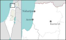
Amka
| Amka עַמְקָה | |
|---|---|
 | |
 Amka | |
| Coordinates: 32°58′46″N 35°9′48″E / 32.97944°N 35.16333°ECoordinates: 32°58′46″N 35°9′48″E / 32.97944°N 35.16333°E | |
| Grid position |
215400/764900 ITM 166/265 PAL |
| District | Northern |
| Council | Matte Asher |
| Region | Western Galilee |
| Founded | 1949 |
| Founded by | Yemenite Jewish immigrants |
| Population (2015)[1] | 644 |
Amka (Hebrew: עַמְקָה), also known in Arabic as Amqa (Arabic: عمقا) is a moshav in the Matte Asher Regional Council of Israel's Northern District, near Acre. The location of the moshav roughly corresponds the former Arab village, depopulated during the 1948 Arab–Israeli War. Yemenite Jews, who arrived from the southern Arab country of Yemen, founded the village's successor Amka in 1949. In 2015 its population was 644.
Etymology
Palmer thought the name Amka to come from the Arabic form of “deep”,[2] while Ringgren suggested that the name preserves the name of Beth Ha-Emek, a city mentioned in Joshua 19:27 as part of the allotment of the Tribe of Asher.[3]
History
Ancient period
During the Roman period, the village located at the same site was called Kefar Amqa.[4] In the Byzantine period the location was probably identified with the village of "Amico".
Middle Ages
During the Crusader period, it was referred to as Amca.[4] In 1179 Joscelin III acquired the land of the village,[5] and in 1220 Jocelyn III´s daughter Beatrix de Courtenay and her husband Otto von Botenlauben, Count of Henneberg, sold their land, including ‘’Amca’’, to the Teutonic Knights.[6]
In 1283, it was mentioned as part of the domain of the Crusaders during the hudna between the Crusaders based in Acre and the Mamluk sultan al-Mansur (Qalawun).[7]
Ottoman era
| Amqa | |
|---|---|
| Arabic | عمقا |
| Also spelled | 'Amqa |
| Subdistrict | Acre |
| Population | 1,240[4][8] (1945) |
| Area |
6,060[4][8] dunams 6.1 km² |
| Date of depopulation | 10–11 July 1948[9] |
| Cause(s) of depopulation | Military assault by Yishuv forces |
| Current localities | Amka[10] |
Incorporated into the Ottoman Empire in 1517 with all of Palestine, 'Amqa appeared in the 1596 tax registers as being in the nahiya (subdistrict) of Akka under the liwa' (district) of Safad, with a population of 215.[11] All the inhabitant were Muslim.[12] The villagers paid taxes on a number of crops, such as wheat, barley, olives, cotton and fruit, and on other types of produce, such as goats and beehives.[11][13]
In the early 18th century the village was under control of Shaykh Najm. He had an agreement to sell the cotton from this and other villages under his control exclusively to the Dutch trader Paul Maashook. In return, Maashook would pay the miri (tax slated for funding the annual Hajj caravan), which was normally payable by the village shaykhs (chiefs).[14] The Syrian Sufi teacher and traveler Mustafa al-Bakri al-Siddiqi (1688–1748/9), who traveled through the region in the first half of the 18th century, said that he prayed in the village after visiting the citadel of Atlit.[4] In 1776 the village was used as a base by Ahmad Pasha al-Jazzar to suppress a revolt led by Ali al-Zahir, one of the sons of Sheikh Zahir al-Umar, who ruled the Galilee between 1730 and 1775.[15]
A map by Pierre Jacotin from Napoleon's invasion of 1799 showed the place, misnamed as El Mead,[16] In the late 19th century, the village was described as being built of stone, situated on a slight rise in a valley, surrounded by olive and fig trees, and arable land. There were an estimated 300 Druze living there.[17] Later, the residents were described as Muslims who maintained a village mosque. In 1887, the Ottoman authorities built a school in ´Amqa.[4]
British Mandate period
In the 1922 census of Palestine conducted by the British Mandate authorities, Amqa had a population of 724 inhabitants, of whom 722 were Muslims and two Christians.[18] The population increased in the 1931 census to 895, all Muslims, living in a total of 212 houses.[19]
In 1945 the population of Amqa was 1,240 Muslims[20] with over 6,000 dunums (1,500 acres) of land according to an official land and population survey.[8] Of this, 1,648 dunams were plantations and irrigable land; 3,348 used for cereals,[21] while 36 dunams were built-up (urban) land.[22]
1948 war and aftermath
Depopulated during the 1948 Arab–Israeli war,[23][24] all that remains of the Arab village structures are an elementary school for boys, founded under Ottoman rule in 1887 and one mosque. The majority of the remaining Arab buildings of Amqa were destroyed by the Israel Defense Forces (IDF) in the late 1950s on the orders of the Israeli government.[4][25][26] The mosque and a schoolroom now used as a warehouse, are the only remaining buildings.[4][27]
The village was captured by Israel's 7th Brigade on 16 July 1948 during Operation Dekel. It was largely destroyed, with the exception of its school and its mosque, and most of its inhabitants were expelled, with the exception of its former Druze inhabitants who still live nearby. Some of the inhabitants remained in Israel as present absentees.[28] On 1 March 1949 a UN observer reported villagers from 'Amqa amongst a large group of people expelled by the IDF which arrived at Salim in the West Bank. He also noted other villagers from 'Amqa in a group expelled on 26 March.[29] In February 1950, the village was declared a closed area.[30] The Arab population remained under Martial Law until 1966. A group of Yemenite Jewish immigrants were settled in Amka in 1949.
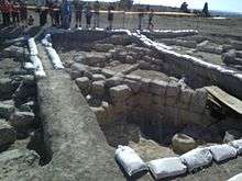
Archaeological sites
Three khirbas (archaeological ruins) lay within Amka's vicinity and contain the foundations of buildings, well-chiseled building stones, presses, and a cistern. During archaeological searches of the area remnants of a Byzantine church were discovered but due to the destruction of the village no foundations could be established.[31][32][33] The Amka mosque was inspected by Petersen in 1991. The date of the mosque construction is not known, but it bears a general similarity to the nearby mosque of al-Ghabisiyya, and is probably of a similar age, i.e. early 19th century.[27]
See also
References
- ↑ "List of localities, in Alphabetical order" (PDF). Israel Central Bureau of Statistics. Retrieved 16 October 2016.
- ↑ Palmer, 1881, p. 40
- ↑ Ringgren, 2000, p. 204.
- 1 2 3 4 5 6 7 8 Khalidi, 1992, p.4
- ↑ Strehlke, 1869, pp. 10-11, No. 11; cited in Röhricht, 1893, RHH, p. 154, No. 579, cited in Frankel, 1988, pp. 257, 263
- ↑ Strehlke, 1869, pp. 43- 44, No. 53; cited in Röhricht, 1893, RHH, p. 248, No. 934 (16); cited in Frankel, 1988, p. 263
- ↑ Barag, 1979, p. 204
- 1 2 3 Government of Palestine, Department of Statistics. Village Statistics, April 1945. Quoted in Hadawi, 1970, p. 40
- ↑ Morris, 2004, p. xvii, village #85. Also gives cause of depopulation.
- ↑ Morris, 2004, p. xxii, Settlement #150.
- 1 2 Hütteroth and Abdulfattah, 1977, p. 192. Quoted in Khalidi, 1992, p. 4
- ↑ 39 households, according to Hütteroth and Abdulfattah, 1977, p. 192
- ↑ Note that Rhode, 1979, p. 6 writes that the register that Hütteroth and Abdulfattah studied was not from 1595/6, but from 1548/9
- ↑ Cohen, 1973, p.12. Cited in Petersen, 2001, p. 93.
- ↑ Petersen, 2001, p. 93. Cohen, 1973, p. 94.
- ↑ Karmon, 1960, p. 162.
- ↑ Conder and Kitchener, 1881, SWP I, p. 145
- ↑ Barron, 1923, Table XI, Sub-district of Acre, p. 36
- ↑ Mills, 1932, p. 99
- ↑ Department of Statistics, 1945, p. 4
- ↑ Government of Palestine, Department of Statistics. Village Statistics, April, 1945. Quoted in Hadawi, 1970, p. 80
- ↑ Government of Palestine, Department of Statistics. Village Statistics, April, 1945. Quoted in Hadawi, 1970, p. 130
- ↑ Nur-eldeen Masalha, ed. (2005). Catastrophe remembered: Palestine, Israel and the internal refugees. Zed Books. p. 73. ISBN 978-1-84277-623-0.
- ↑ Khalidi, 1992, p. 5
- ↑ Ellenblum, 2003, p. 177
- ↑ Torstrick Rebecca L. (2000) The Limits of Coexistence: Identity Politics in Israel University of Michigan Press, ISBN 0-472-11124-8 p 180
- 1 2 Petersen, 2001, p. 93.
- ↑ Charles S. Kamen (1987). "After the Catastrophe I: The Arabs in Israel, 1948-51". Middle Eastern Studies. 23: 453–495. doi:10.1080/00263208708700721.; Sabri Jiryis (1973). "The Legal Structure for the Expropriation and Absorption of Arab Lands in Israel". Journal of Palestine Studies. 2: 82–104. doi:10.1525/jps.1973.2.4.00p0099c.
- ↑ Morris, 1993, pp. 146-147
- ↑ S. Jiryis (1976). The land question in Israel. New York and London: Monthly Review Press. p. 90. ISBN 0-85345-377-2.
- ↑ Ellenblum, 2003, p. 178
- ↑ The War for Palestine (second Edition 2007) Rogan and Shlaim Cambridge University Press ISBN 978-0-521-87598-1 p 66
- ↑ Khoury, Elias (2007) Gate of the Sun: Bab Al-Shams Translated by Humphrey Davies Macmillan, ISBN 0-312-42670-4 p 308
Bibliography
- Barag, Dan (1979). "A new source concerning the ultimate borders of the Latin Kingdom of Jerusalem". Israel Exploration Journal. 29: 197–217.
- Barron, J. B., ed. (1923). Palestine: Report and General Abstracts of the Census of 1922. Government of Palestine.
- Cohen, A. (1973), Palestine in the Eighteenth Century: Patters of Government and Administration. Hebrew University, Jerusalem. Cited in Petersen, (2001)
- Conder, Claude Reignier; Kitchener, H. H. (1881). The Survey of Western Palestine: Memoirs of the Topography, Orography, Hydrography, and Archaeology. 1. London: Committee of the Palestine Exploration Fund.
- Department of Statistics (1945). Village Statistics, April, 1945. Government of Palestine.
- Ellenblum, Ronnie (2003). Frankish Rural Settlement in the Latin Kingdom of Jerusalem. Cambridge University Press. ISBN 9780521521871.
- Frankel, Rafael (1988). "Topographical notes on the territory of Acre in the Crusader period". Israel Exploration Journal. 38 (4): 249–272.
- Guérin, Victor (1880). Description Géographique Historique et Archéologique de la Palestine (in French). 3: Galilee, pt. 2. Paris: L'Imprimerie Nationale. (p.23)
- Hadawi, Sami (1970). Village Statistics of 1945: A Classification of Land and Area ownership in Palestine. Palestine Liberation Organization Research Center.
- Hütteroth, Wolf-Dieter; Abdulfattah, Kamal (1977). Historical Geography of Palestine, Transjordan and Southern Syria in the Late 16th Century. Erlanger Geographische Arbeiten, Sonderband 5. Erlangen, Germany: Vorstand der Fränkischen Geographischen Gesellschaft. ISBN 3-920405-41-2.
- Karmon, Y. (1960). "An Analysis of Jacotin's Map of Palestine" (PDF). Israel Exploration Journal. 10 (3,4): 155–173; 244–253.
- Khalidi, Walid (1992). All That Remains: The Palestinian Villages Occupied and Depopulated by Israel in 1948. Washington D.C.: Institute for Palestine Studies. ISBN 0-88728-224-5.
- Mills, E., ed. (1932). Census of Palestine 1931. Population of Villages, Towns and Administrative Areas (PDF). Jerusalem: Government of Palestine.
- Morris, Benny (1993). Israel's Border Wars, 1949 - 1956. Arab Infiltration, Israeli Retaliation, and the Countdown to the Suez War. Oxford University Press. ISBN 0-19-827850-0.
- Morris, Benny (1987). The Birth of the Palestinian refugee problem, 1947-1949. Cambridge University Press. ISBN 0-521-33028-9.
- Morris, Benny (2004). The Birth of the Palestinian Refugee Problem Revisited. Cambridge University Press. ISBN 0-521-00967-7.
- Nazzal, Nafez (1978). The Palestinian Exodus from Galilee 1948. Beirut: The Institute for Palestine Studies.
- Palmer, E. H. (1881). The Survey of Western Palestine: Arabic and English Name Lists Collected During the Survey by Lieutenants Conder and Kitchener, R. E. Transliterated and Explained by E.H. Palmer. Committee of the Palestine Exploration Fund.
- Petersen, Andrew (2001). A Gazetteer of Buildings in Muslim Palestine (British Academy Monographs in Archaeology). 1. Oxford University Press. ISBN 978-0-19-727011-0.
- Rhode, Harold (1979). Administration and Population of the Sancak of Safed in the Sixteenth Century. Columbia University.
- Rogan, Eugene (2001). The War for Palestine: Rewriting the History of 1948. Cambridge: Cambridge University Press. ISBN 0-521-79476-5.
- Röhricht, Reinhold (1893). (RRH) Regesta regni Hierosolymitani (MXCVII-MCCXCI) (in Latin). Berlin: Libraria Academica Wageriana.
- Strehlke, Ernst, ed. (1869). Tabulae Ordinis Theutonici ex tabularii regii Berolinensis codice potissimum. Berlin: Weidmanns.
External links and references
- Welcome To 'Amqa
- Survey of Western Palestine, Map 3: IAA, Wikimedia commons
- 3amqa, Dr. Moslih Kanaaneh