Yazur
| Yazur | |
|---|---|
|
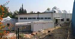
Tomb (Maqam) of Imam ´Ali, now housing the Sha´arei Zion Synagogue | |
 Yazur | |
| Arabic | يازور |
| Name meaning | Yazur[1][2] |
| Subdistrict | Jaffa |
| Coordinates | 32°01′44″N 34°47′58″E / 32.02889°N 34.79944°ECoordinates: 32°01′44″N 34°47′58″E / 32.02889°N 34.79944°E |
| Palestine grid | 131/159 |
| Population | 4,030[3] (1945) |
| Area |
9742[3] dunams 9.7 km² |
| Date of depopulation | 1 May 1948[4] |
| Cause(s) of depopulation | Military assault by Yishuv forces |
| Secondary cause | Influence of nearby town's fall |
| Current localities | Azor,[5] Holon |
Yazur (Arabic: يازور, Hebrew: יאזוּר) was a Palestinian Arab town located 6 kilometers (3.7 mi) east of Jaffa. Mentioned in 7th century BCE Assyrian texts, the village was a site of contestation between Muslims and Crusaders in the 12th-13th centuries.
During the Fatimid period in Palestine, a number of important people were born in Yazur. In modern times the town was the birthplace of Ahmed Jibril, the founder and current head of the Popular Front for the Liberation of Palestine – General Command (PFLP-GC).
The Israeli town of Azor now stands on the former town lands of Yazur, which was depopulated and mostly destroyed during the 1947–48 Civil War in Mandatory Palestine.
History
Iron Age
The village is mentioned in the annals of the Assyrian ruler Sennacherib (704 – 681 BCE) as Azuro.[6]
Fatimid, Crusader, Ayyubid and Mamluk periods
The Arab geographer Yaqut al-Hamawi (1179–1229) described Yazur as a small town[7] that was the birthplace of several important figures during the Fatimid period, most prominent among them, al-Hasan ibn ´Ali al-Yazuri, who became a Fatimid minister in 1050 CE.[6] In the twelfth and thirteenth centuries CE, Muslim and Crusader forces fought for control of the village and it changed hands several times, before finally falling under the control of the Mamluks.[6]
Ottoman era
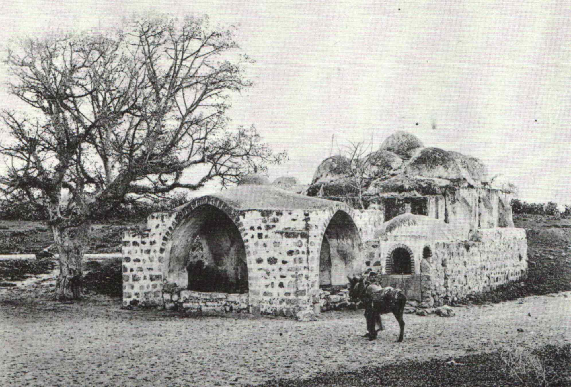
During early Ottoman rule in Palestine, the revenues of the village of Yazur were in 1557 designated for the new waqf of Hasseki Sultan Imaret in Jerusalem, established by Hasseki Hurrem Sultan (Roxelana), the wife of Suleiman the Magnificent.[8] In 1586, the Maqam Imam ´Ali in Yazur was seen by Zuallart, who described it as follows: "....a little further was a square mosque with nine little cupolas. Across the road there is a well or cistern."[9] In 1596, Yazur was a village in the nahiya ("subdistrict") of Ramla ( liwa' ("district") of Gaza), with a population of 275. Villagers paid taxes to the authorities for the crops that they cultivated, which included wheat, barley, fruit, and sesame as well as on other types of property, such as goats and beehives.[10] In 1602, Seusenius described the Maqam Imam ´Ali as "a mosque with nine cupolas the one in the middle being the highest".[11]
The Syrian Sufi teacher and traveller Mustafa al-Bakri al-Siddiqi (1688-1748/9) who travelled in the region in the first half of the eighteenth century, and Mustafa al-Dumyati (d. 1764) reported visiting the shrine of a sage called Sayyiduna ("our master") Haydara in Yazur.[6] In 1863 Victor Guérin visited.[12]
While still under the rule of the Ottoman Empire in 1870, Charles Netter from Alliance Israélite Universelle founded the Mikveh Israel southeast of Jaffa. Through a firman of the sultan, he received land for the school which until then had been worked by the fellahin of the village of Yazur. In a Survey of Western Palestine (1882), it is noted that, "Though the land belongs to the Government, the Fellahin, from long usage, have got to look upon it as virtually their own, and resent its occupation by any other person." The peasants therefore became bitter enemies of the school farm.[13]
In the late summer of 1870, the governor of Damascus visited Jaffa. Accompanied by Netter and two Templars, Hoffmann and Ernst Hardegg, the governor also passed by Yazur:
While riding between Natter's property and the city, the Wali was beset by Arab women and men who begged him, holding onto the reigns of his mule, and onto his trousers, to help them regain their rights, the Jews were taking away their land; here they pointed at Natter, who rode next to the Wali, screaming "the Jews, the Jews." The Pasha, riding on the other side, asked Ernst for his riding crop and chased them away himself. The Wali accepted a petition handed him by a shaykh, incidentally.[14]
The Palestine Exploration Fund's Survey of Western Palestine also reported that in 1882 the village structures were built of adobe brick with dispersed gardens and wells, and that Yazur contained a domed shrine.[15]
British mandate era
Modern Yazur was divided into four quarters, one for each of four clans (hama´il, sing. hamula) that lived there. The houses were made of stone or adobe brick and straw and were built in groups called ahwash (pl. of hawsh, "courtyard"). Each house in such a group opened onto a common courtyard that had a single entrance, often an arched gate. The village had two elementary schools, one for boys (built in 1920) and another for girls (opened in 1933). The boys´school occupied 27 dunums (the bulk of which was allocated for training students in agronomy) and had its own artesian well. In 1947, 430 boys and 160 girls were registered in these schools. The remains of an old Crusader church built by Richard the Lionheart in 1191, called Castel des Plaines, were visible on a hill inside the village. The Crusader church had been rebuilt to serve as Yazur's mosque.According to a census conducted in 1931 by the British Mandate authorities, Yazur had a population of 2,337 inhabitants in, 419 houses.[16] According to a 1945 census conducted by the Mandatory authorities in Palestine, Yazur had a population of 4,030, mostly Muslim Arabs with a small Arab Christian community of 20 people.[6]
Agriculture constituted the backbone of the economy; in 1944, citrus was planted on 6,272 dunums and 1,441 dunums were allocated to cereals. Agriculture was both rainfed and irrigated; 1,689 dunums were irrigated or used for orchards. During World War II, the villagers also started raising Holstein cows, and by 1947 numerous artesian wells were being used for irrigation.[6]
Lead-up to 1947-1948 war, and after
The Filastin newspaper reported that on December 11, 1947, members of a pro-Zionist armed group drove at high speed through the town, throwing bombs at a barbershop and a coffeehouse. They did not cause any fatalities. However, Aref al-Aref reports that one week later, on the 18th of December, more Zionist troops returned, this time disguised as British soldiers. Driving through the main road they threw several bombs at a coffeehouse, killing six villagers.[6] Filastin reported that on 30 December, yet another Zionist raiding party had tried to blow up village houses. This group had been discovered by the village guards, and driven away.[6] More attacks followed early 1949. The largest came on 12 February, when Yazur and Abu Kabir were attacked by mortars and machine-guns. Several houses in Yazur were destroyed. Attacks followed almost weekly, including on 20 February when Zionist forces attacked the village with tanks and armoured vehicles, destroying an ice factory, two houses, and killing one villager and wounding another four.[17][18]
Yazur was depopulated during the 1947–48 Civil War in Mandatory Palestine, weeks prior to the outbreak of the wider 1948 Arab-Israeli War, during the Haganah's offensive Operation Hametz 28–30 April 1948. This operation was held against a group of villages east of Jaffa, including Yazur. According to the preparatory orders, the objective was "opening the way [for Jewish forces] to Lydda". Though there was no explicit mention of the prospective treatment of the villagers, the order spoke of "cleansing the area" [tihur hashetah].[19] The final operational order stated: "Civilian inhabitants of places conquered would be permitted to leave after they are searched for weapons." Soldiers were instructed to not harm women and children "insofar as possible" and to not loot captured villages.[20]
The village today
According to Walid Khalidi, 1992, two shrines still remain standing in the village. One is made of stone and its roof is topped with a dozen domes clustered around a more prominent dome at the center. A number of other structures and houses are also still intact; some are utilized, while others are vacant. One house, occupied by a Jewish family, is a two-storey concrete unit that has a rectangular door and a modified gabled roof.[17]

According to Petersen, the small mosque/shrine located at a distance of some 50 meters from Maqam Imam ´Ali, on the opposite side of the road was known as Shaykh al-Katanan. Inspected in 1991, it was found to be built on a square plan with a shallow dome resting on an octagonal drum. The building is entered through a doorway in the middle of the north side. Inside there are windows on the west and east side flanked by niches. In the middle of the south wall is a shallow niche, which was found decorated with inscriptions painted in henna.[21]

According to Meron Benvenisti, 2000, in the village of Yazur lies the venerated grave of Imam ´Ali, a famous miracle-worker whose grave is purported to be located in another dozen places as well. But the Yazur site, a massive building whose central dome is encircled by nine smaller ones, is most widely held to be the actual burial site of Imam ´Ali, whose tomb is almost the sole monument left in the village. Two or three broken gravestones remain in the adjoining Muslim cemetery, which now serves as a dump for "yard trash only." The tomb building now houses the Sha´arei Zion Synagogue and a seminary for Orthodox Jews. On the roof, beside the domes, a satellite dish has been installed to receive live religious broadcasts. Across the road, in the Holon industrial park, is located yet another Muslim holy site, this one deserted and falling into pieces.[22]
Persons associated with Yazur
- Ahmed Jibril - founder and head of PFLP-GC
- Hassan ibn Ali al-Yazuri - The Sunni vizier and chief judge of Fatimid ruler Al-Mustansir Billah, from 1050-58[23]
See also
References
- ↑ Palmer, 1881, p. 220
- ↑ The original name said to be Adalia, according to a local, see Clermont-Ganneau, in QSPEF, 1874, p 5
- 1 2 Government of Palestine, Department of Statistics. Village Statistics, April, 1945. Quoted in Hadawi, 1970, p. 53
- ↑ Morris, 2004, p. xviii, village #215. Also gives cause(s) of depopulation.
- ↑ Morris, 2004, p. xxi, Settlement #92.
- 1 2 3 4 5 6 7 8 Khalidi 1992, p. 261
- ↑ le Strange, 1890, p. 553
- ↑ Singer, 2002, p. 50
- ↑ Zuallart, 1587, part III, p.112. Translated and quoted in Petersen, 2001, p. 311
- ↑ Hütteroth and Abdulfattah,1977, p. 155. Quoted in Khalidi 1992, p. 261
- ↑ Martinus Seusenius' reise in das Heilige Land i.j. 1602/03 Cited in Petersen, 2001, p. 311
- ↑ Guérin, 1868, pp 26-29
- ↑ Conder and Kitchener, 1882, SWP II, pp. 256 f. Quoted in Schölch, 1993, p.281.
- ↑ Die Warte, 29 September 1870, Quoted in Schölch, 1993, p. 281.
- ↑ Conder and Kitchener, 1882, SWP II, p. 258, Quoted in Khalidi, 1992, p. 261
- ↑ Mills, 1932, p. 16
- 1 2 Khalidi, 1992, p. 262
- ↑ Morris, 2008, p. 100
- ↑ HGS\Operations to Alexandroni, etc., "Orders for Operation "Hametz", 26 Apr. 1948. IDFA 6647\49\\15. Cited in Morris, 2004, pp. 217, 286
- ↑ Operation Hametz HQ to Givati, etc., 27 Apr. 1948, 14:00 hours, IDFA 67\51\\677. See also Alexandroni to battalions, 27 Apr. 1948, IDFA 922\75\\949. Cited in Morris, 2004, pp. 217, 286
- ↑ Fisher et al. 1996. Cited in Petersen, 2001, p. 312
- ↑ Benvenisti, 2000, p. 292
- ↑ Farhad Daftary (22 Feb 2001). Mediaeval Isma'ili History and Thought. Cambridge University Press. p. 109. ISBN 9780521003100.
Bibliography
| Wikimedia Commons has media related to Shaykh al-Katanan. |
| Wikimedia Commons has media related to Tomb (Maqam) of Imam ´Ali. |
- Barron, J. B., ed. (1923). Palestine: Report and General Abstracts of the Census of 1922. Government of Palestine.
- Benvenisti, Meron (2000). Sacred Landscape: The Buried History of the Holy Land since 1948. University of California Press. (pp. 32–33, 292)
- Brink, van den, Edwin C.M. (2005-04-14). "Azor l Report" (117). Hadashot Arkheologiyot – Excavations and Surveys in Israel.
- Buchennino, Aviva (2009-03-12). "Azor l Report" (118). Hadashot Arkheologiyot – Excavations and Surveys in Israel.
- Clermont-Ganneau, Charles Simon (1896). [ARP] Archaeological Researches in Palestine 1873-1874, translated from the French by J. McFarlane. 2. London: Palestine Exploration Fund. (pp. 5, 254, 489)
- Conder, Claude Reignier; Kitchener, H. H. (1882). The Survey of Western Palestine: Memoirs of the Topography, Orography, Hydrography, and Archaeology. 2. London: Committee of the Palestine Exploration Fund.
- Gorzalczany, Amir (2009-03-12). "Azor, Ha-Histadrut Street Final Report l Report" (121). Hadashot Arkheologiyot – Excavations and Surveys in Israel.
- Guérin, Victor (1868). Description Géographique Historique et Archéologique de la Palestine (in French). 1: Judee, pt. 1. Paris: L'Imprimerie Nationale.
- Hadawi, Sami (1970). Village Statistics of 1945: A Classification of Land and Area ownership in Palestine. Palestine Liberation Organization Research Center.
- Hütteroth, Wolf-Dieter; Abdulfattah, Kamal (1977). Historical Geography of Palestine, Transjordan and Southern Syria in the Late 16th Century. Erlanger Geographische Arbeiten, Sonderband 5. Erlangen, Germany: Vorstand der Fränkischen Geographischen Gesellschaft. ISBN 3-920405-41-2.
- Khalidi, Walid (1992). All That Remains: The Palestinian Villages Occupied and Depopulated by Israel in 1948. Washington D.C.: Institute for Palestine Studies. ISBN 0-88728-224-5.
- Mariti, Giovanni (1792). Travels Through Cyprus, Syria, and Palestine; with a General History of the Levant. 1. Dublin: P. Byrne. (pp. 406-7)
- Mills, E., ed. (1932). Census of Palestine 1931. Population of Villages, Towns and Administrative Areas. Jerusalem: Government of Palestine.
- Morris, Benny (2004). The Birth of the Palestinian Refugee Problem Revisited. Cambridge University Press. ISBN 978-0-521-00967-6.
- Morris, Benny (2008). 1948: A History of the First Arab-Israeli War. Yale University Press. ISBN 9780300126969.
- Palmer, E. H. (1881). The Survey of Western Palestine: Arabic and English Name Lists Collected During the Survey by Lieutenants Conder and Kitchener, R. E. Transliterated and Explained by E.H. Palmer. Committee of the Palestine Exploration Fund.
- Petersen, Andrew (2001). A Gazetteer of Buildings in Muslim Palestine (British Academy Monographs in Archaeology). I. Oxford University Press. ISBN 978-0-19-727011-0.
- Pringle, Denys (1997). Secular buildings in the Crusader Kingdom of Jerusalem: an archaeological Gazetter. Cambridge University Press. ISBN 0521 46010 7. (p. 108 )
- al-Qawuqji, Fauzi (1972): Memoirs of al-Qawuqji, Fauzi in Journal of Palestine Studies
- "Memoirs, 1948, Part I" in 1, no. 4 (Sum. 72): 27-58., dpf-file, downloadable
- "Memoirs, 1948, Part II" in 2, no. 1 (Aut. 72): 3-33., dpf-file, downloadable
- Romano, Amit (2004-06-09). "Azor Final Report" (116). Hadashot Arkheologiyot – Excavations and Surveys in Israel.
- Schölch, Alexander (1993): Palestine in Transformation, 1856–1882, ISBN 0-88728-234-2,
- Singer, A. (2002). Constructing Ottoman Beneficence: An Imperial Soup Kitchen in Jerusalem. Albany: State of New York Press.
- Strange, le, Guy (1890). Palestine Under the Moslems: A Description of Syria and the Holy Land from A.D. 650 to 1500. Committee of the Palestine Exploration Fund.
- Torge, Hagit (2005-03-28). "Azor Final Report l Report" (117). Hadashot Arkheologiyot – Excavations and Surveys in Israel.
- Wilson, Charles Williams, ed. (1881, 1884): Picturesque Palestine, Sinai and Egypt. vol 3 of 4. (p. 141, 143 ff )
- Zuallart, Jean, (1587): Il devotissimo viaggio di Gervsalemme Yazur p. 11 & 112 in the 1585-edition
External links
- Welcome To Yazur
- Survey of Western Palestine, Map 13: Wikimedia commons
- Yazur at Khalil Sakakini Cultural Center
- Photo of Imam Ali Mosque, circa 1887
| |||||||
| |||||||