Ein al-Zeitun
| Ein al-Zeitun | |
|---|---|
|
| |
 Ein al-Zeitun | |
| Arabic | عين الزيتون |
| Name meaning | "spring of olives"[2] |
| Also spelled | Ayn az-Zaytun |
| Subdistrict | Safad |
| Coordinates | 32°59′14.02″N 35°29′29.58″E / 32.9872278°N 35.4915500°ECoordinates: 32°59′14.02″N 35°29′29.58″E / 32.9872278°N 35.4915500°E |
| Palestine grid | 196/265 |
| Population | 820[3][4] (1945) |
| Area |
1,100[3] dunams 1.1 km² |
| Date of depopulation | May 2, 1948[5] |
| Cause(s) of depopulation | Military assault by Yishuv forces |
| Current localities | None |
Ein al-Zeitun, also spelled Ein Zaytun, Ein ez-Zeitun, Ain al-Zaytun or Ain el-Zeitun, was a Palestinian Arab village, located 1.5 kilometres (0.93 mi) north of Safad in the Upper Galilee. In 1945, the village had a population of 820 inhabitants and a total land area of 1,100 dunams.[3] Ein al-Zeitun was entirely Muslim. The village's small population and land area as well as its proximity to Safad made it a suburb of the city. The village was depopulated in 1948, after the Ein al-Zeitun massacre.
Location
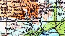
Ein al-Zeitun was located on the western slope of Wadi al-Dilb, next to the highway leading to Safad, 1.5 kilometres (0.93 mi) north of the city.
History
Wadi al-Dilb may have been the wadi that Al-Dimashqi (d. 1327) called Wadi Dulayba, which he described as lying between Mirun and Safad. Al-Dimashqi described a spring where water gushed forward for one or two hours, allowing people to collect drinking water and wash, before it abruptly retreated.[6] The village name, which was Arabic for "spring of olives", did indicate that there was a spring in the vicinity.[7]
Under the Ottoman Empire in the 16th century, Ein al-Zeitun was a town in the nahiya ("subdistrict") of Jira, part of Sanjak Safad, with a mixed population of Muslims and Jews. Tax registers in 1596 recorded 59 Muslim households and 6 bachelors, plus 45 Jewish households and 3 bachelors. It paid taxes on olives, grapes, wheat and barley, as well as on vineyards and orchards.[8][9]
The village was destroyed, along with Safed and other nearby villages, in an earthquake in 1837.[10]
Victor Guérin, who visited in 1875, found a village with two springs, surrounded by slopes covered in olives, figs, walnuts and vegetables. The population consisted of 350 Muslims.[11]
In 1881, the Palestine Exploration Fund's Survey of Western Palestine (SWP) described Ain al Zeitun as a stone-built village on top of a hill north of Safad. The village had then a population of 200-350, and it was surrounded by arable land.[12]
British Mandate era
In the 1922 census of Palestine conducted by the British Mandate authorities, 'Ain Zaitun had a population of 386, all Muslims,[13] increasing in the 1931 census to 567, still all Muslims, in a total of 127 houses.[14]
The town contained a mosque and a boys' elementary school. The villagers cultivated olives, grain and fruit, especially grapes. In 1944/45, with a population of 820, a total of 280 dunums of village land was used for cereals, 477 dunums were irrigated or used for orchards,[15][16] while 35 dunams were classified as urban (built-up) land.[17]
1948 War and aftermath
According to Ilan Pappé, the Jewish troops followed a policy of massacres in villages close to Arab urban centres, in order to precipitate the flight of the people in the cities and towns nearby. This was the case of Nasir al-Din near Tiberias, Ein al-Zeitun near Safad, and Tirat Haifa near Haifa. In all villages groups of "males between the age of 10 and 50", were executed in order to intimidate and terrorise the village population and those living in nearby towns.[18]
Ein al-Zeitun was captured by Palmach troops on May 2, 1948. Immediately prior to the capture, most of the young and middle-aged males fled the town. The remaining population was expelled by Israeli forces in the following days. Between 30 and 70 unarmed Arab prisoners were killed afterwards. One man, Rashid Khalil, was killed after a group of the village's inhabitants attempted to return to Ein al-Zeitun.[15][19][20]
Palestinian historian Walid Khalidi, describing the place in 1992, found that:
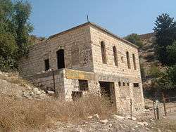
The rubble of destroyed stone houses is scattered throughout the site, which is otherwise overgrown with olive trees and cactuses [cacti]. A few deserted houses remain, some with round arched entrances and tall windows with various arched designs. In one of the remaining houses, the smooth stone above the entrance arch is inscribed with Arabic calligraphy, a fixture of Palestinian architecture. The well and the village spring also remain.[15]
In 2004 the remains of the Ein al-Zeitun mosque was turned into a milk farm. The Jewish owner removed the stone that indicated the founding date of the mosque and covered the walls with Hebrew graffiti.[1]
Portrayals in art
Oral histories from Ein al-Zeitun provided Elias Khoury with material for his 1998 book Bab al Shams (Gate of the Sun), which was filmed in 2004.[21][22]
Israeli author Netiva Ben-Yehuda was in the village when the massacre happened, and wrote the following about it:
But Yehonathan continued to yell, and suddenly he turned with his back to Mairke, and walked away furiously, all the time continuing to complain: "He is out of his mind! Hundreds of people are lying there tied! Go and kill them! Go and waste hundreds of people! A madman kills people bound like this and only a madman wastes all the ammunition on them!...I don´t know who they had in mind, who is coming to inspect them, but I understand it's become urgent, suddenly we have to untie the knots around these POW´ s hands and legs, and then I realized they are all dead, "problem solved".[23]
See also
- List of Arab towns and villages depopulated during the 1948 Arab-Israeli War
- Biriya Forest
- Ein Zeitim
References
- 1 2 Pappé, 2006, p. 217
- ↑ Palmer, 1881, p. 65
- 1 2 3 Government of Palestine, Department of Statistics. Village Statistics, April, 1945. Quoted in Hadawi, 1970, p. 69
- ↑ Department of Statistics, 1945, p. 9
- ↑ Morris, 2004, p. xvi, village #53. Also provides cause of depopulation.
- ↑ Nukhbat, cited in Khalidi, 1992, p. 436.
- ↑ Khalidi, 1992, p. 436
- ↑ Hütteroth and Abdulfattah, 1977, p. 175
- ↑ Note that Rhode, 1979, p. 6 writes that the register that Hütteroth and Abdulfattah studied was not from 1595/6, but from 1548/9
- ↑ Nicholas N. Ambraseys (4 August 1997). "The earthquake of 1 January 1837 in Southern Lebanon and Northern Israel". Annali di Geofisica. XL (N): 923–935.
- ↑ Guérin, 1880, p. 427 ff
- ↑ Conder and Kitchener, 1881, SWP I, p.196. Quoted in Khalidi, 1992, p.437
- ↑ Barron, 1923, Table XI, Sub-district of Safad, p. 41
- ↑ Mills, 1932, p. 106
- 1 2 3 Khalidi, 1992, p. 437
- ↑ Government of Palestine, Department of Statistics. Village Statistics, April, 1945. Quoted in Hadawi, 1970, p. 118
- ↑ Government of Palestine, Department of Statistics. Village Statistics, April, 1945. Quoted in Hadawi, 1970, p. 168
- ↑ Pappé, 2006, p.110
- ↑ Nazzal, 1978, p.37
- ↑ Morris, 2004, p. 202
- ↑ Pappé, 2006, pp. 111, 113
- ↑ Bab el Shams
- ↑ Ben Yehuda: Between the Knots, pp. 245-6. Cited in Pappé, 2006, p. 112
Bibliography
| Wikimedia Commons has media related to Ein al-Zeitun. |
- Barron, J. B., ed. (1923). Palestine: Report and General Abstracts of the Census of 1922. Government of Palestine.
- Conder, Claude Reignier; Kitchener, H. H. (1881). The Survey of Western Palestine: Memoirs of the Topography, Orography, Hydrography, and Archaeology. 1. London: Committee of the Palestine Exploration Fund.
- Department of Statistics (1945). Village Statistics, April, 1945. Government of Palestine.
- Guérin, Victor (1880). Description Géographique Historique et Archéologique de la Palestine (in French). 3: Galilee, pt. 2. Paris: L'Imprimerie Nationale.
- Hadawi, Sami (1970). Village Statistics of 1945: A Classification of Land and Area ownership in Palestine. Palestine Liberation Organization Research Center.
- Hütteroth, Wolf-Dieter; Abdulfattah, Kamal (1977). Historical Geography of Palestine, Transjordan and Southern Syria in the Late 16th Century. Erlanger Geographische Arbeiten, Sonderband 5. Erlangen, Germany: Vorstand der Fränkischen Geographischen Gesellschaft. ISBN 3-920405-41-2.
- Khalidi, Walid (1992). All That Remains:The Palestinian Villages Occupied and Depopulated by Israel in 1948. Washington D.C.: Institute for Palestine Studies. ISBN 0-88728-224-5.
- Mills, E., ed. (1932). Census of Palestine 1931. Population of Villages, Towns and Administrative Areas. Jerusalem: Government of Palestine.
- Morris, Benny (2004). The Birth of the Palestinian Refugee Problem Revisited. Cambridge University Press. ISBN 978-0-521-00967-6.
- Nazzal, Nafez (1978). The Palestinian Exodus from Galilee 1948. Beirut: The Institute for Palestine Studies.
- Palmer, E. H. (1881). The Survey of Western Palestine: Arabic and English Name Lists Collected During the Survey by Lieutenants Conder and Kitchener, R. E. Transliterated and Explained by E.H. Palmer. Committee of the Palestine Exploration Fund.
- Pappé, Ilan (2007). The Ethnic Cleansing of Palestine. London and New York: Oneworld. ISBN 1-78074-056-5.
- Rhode, Harold (1979). Administration and Population of the Sancak of Safed in the Sixteenth Century. Columbia University.
External links
- Welcome to Ayn-al-Zaytun
- Survey of Western Palestine, Map 4: IAA, Wikimedia commons
- Ayn al-Zaytun, at Khalil Sakakini Cultural Center
- Ayn al-Zaytun, Dr. Khalil Rizk.
- 3ein Al-Zaytoon, from Dr. Moslih Kanaaneh