Yibna
| Yibna | |
|---|---|
|
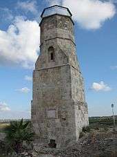
Mamluk minaret in Yibna | |
 Yibna | |
| Arabic | يبنى |
| Name meaning | Built (God "Allah" Builts)[1] |
| Also spelled | Jabneel, Iamnia, Jamnia |
| Subdistrict | Ramle |
| Coordinates | 31°51′57.50″N 34°44′46.75″E / 31.8659722°N 34.7463194°ECoordinates: 31°51′57.50″N 34°44′46.75″E / 31.8659722°N 34.7463194°E |
| Palestine grid | 126/141 |
| Population | 5,420 (1945) |
| Area | 59,554 dunams |
| Date of depopulation | 4 June 1948[2] |
| Cause(s) of depopulation | Military assault by Yishuv forces |
| Secondary cause | Expulsion by Yishuv forces |
| Current localities | Yavne,[3] Beit Raban, Kfar HaNagid, Beit Gamliel |
Yibna' (Arabic: يبنى; Jabneel in Biblical times; Iamnia, Jamnia, or Yavne in Roman times; Ibelin to the Crusaders), was a Palestinian village with a population of 5,420 in 1948, located 15 kilometers southwest of Ramla.[4] Yibna was occupied by Israeli forces on 4 June 1948, and was depopulated during the military assault and expulsion.[5]
History

Pre-Islamic periods
Based on written sources and archaeology, the history of Yavneh/Jabneh/Yibna goes back to the Iron Age and possibly to the Bronze Age. The Hebrew Bible mentions Yavneh repeatedly, as does Josephus. For more see Yavne.
The harbour of Javneh
The harbour of ancient Yavneh has been identified on the coast at Minet Rubin (Arabic) or Yavne-Yam (Hebrew), where excavations have revealed fortification going back to the Bronze Age Hyksos.[7] It has been in use from the Middle Bronze Age until the 12th century CE, when it was abanodoned.[8] For more see Yavne-Yam.
Early Islamic period
The Islamic historian al-Baladhuri (died 892 CE) mentioned Yibna as one of ten towns in Jund Filastin conquered by the Rashidun army led by 'Amr ibn al-'As in the early 7th century.[9]
Also in the 9th century, Ya'qubi (died 897/8 CE) wrote that Yubna was an ancient city built on a hill that was inhabited by Samaritans.[10]
Al-Muqaddasi, writing around 985, said that "Yubna has a beautiful mosque. From this place come the excellent figs known by the name of Damascene."[11] Yaqut wrote that in Yubna there was a tomb said to be that of Abu Hurairah, the companion (sahaba) of the Prophet. The author of Marasid also adds that tomb seen here is also said to be that of ´Abd Allah ibn Abi Sarh, another companion (sahaba) of the Prophet.[10]
In 2007, remains ranging from the Early Islamic period until the British Mandate period were uncovered.[12] An additional kiln, and part of a commercial/industrial area were uncovered at the west of the tell in 2009.[13]
Crusader, Ayyubid and Mamluk periods
The Crusaders called the city Ibelin and built a castle there in 1141.Two excavation seasons led by Professor Dan Bahat starting in 2005 revealed the main gate. Its namesake noble family, Ibelin, was important in the Kingdom of Jerusalem and later in the Kingdom of Cyprus. Ibelin was captured by Saladin in 1187. Salvage excavations at the west of the tell unearthed a stash of 53 Crusader coins of the 12th and 13th centuries.[13]
Ibelin's parish church was transformed into a mosque, to which a minaret was added during the Mamluk period in 1337. The minaret survives until today, while the mosque (the former Crusader church) was blown up by the IDF in 1950.[6][14]
Maqam Abu Hurayra, described as "one of the finest domed mausoleums in Palestine", is located in Yavne. Since the 12th century, it has been known as a tomb of Abu Hurairah, a companion (sahaba) of the Islamic prophet Muhammad. After 1948 the shrine has been taken over by Sephardic Jews who believe that the tomb is the burial place of Rabbi Gamaliel of Yavne.[15]
Ottoman period
In 1596, Yibna was part of the Ottoman Empire, nahiya (subdistrict) of Gaza under the liwa' (district) of Gaza with a population of 710. It paid taxes on a number of crops, including wheat, barley, summer crops, sesame seeds and fruits, as well as goats, beehives and vineyards.[16]
An American missionary, William Thomson, who visited Yibna in 1834, described it as a village on hill inhabited by 3,000 Muslim residents who worked in agriculture. He wrote that an inscription on the mosque indicated that it had been built in 1386, while Denys Pringle indicates 1337 as the construction year of the minaret.[6][17][18] In the late 19th century, Yibna was described as a large village partly built of stone and situated on a hill. It had olive trees and corn to the north, and gardens nearby.[19]
British Mandate
In 1921, an elementary school for boys was founded in Yibna. By 1941-42 it had 445 students. A school for girls was founded in 1943, and by 1948 it had 44 students.[4]
In the 1922 census of Palestine conducted by the British Mandate authorities, Yebna had a population of 1,791 inhabitants; all Muslims,[20] increasing in the 1931 census to 3,600 inhabitants; 2 Jews, 7 Christians, 1 Bahai, and 3,590 Muslims, in a total of 794 houses.[21]
In 1941, Kibbutz Yavne was established nearby by refugees from Germany, followed by a Youth Aliyah village, Givat Washington, in 1946.[4]
In 1944-45 the village had a population of 5,420, while the total land area was 59,554 dunams, according to an official land and population survey.[22] In addition there were 1,500 nomads living around the village.[4] A total of 6,468 dunums of village land was used for citrus and bananas, 15,124 dunums were used for cereals, 11,091 dunums were irrigated or used for orchards, of which 25 dunums were planted with olive trees,[4][23] while 127 dunams were classified as built-up, urban areas.[24]
1948 and aftermath
In mid-March 1948, a contingent of Iraqi soldiers moved into the village. In a Haganah reprisal on March 30, two dozen villagers were killed. On April 21, the village commander was arrested by the British authorities for the drunken shooting of two Arabs.[25]
During the Arab-Israeli war, residents of Zarnuqa sought refuge in Yibna, but left after the villagers accused them of being traitors.[26]
On 27 May, following the fall of Al-Qubayba and Zarnuqa, most of the population of Yibna fled to Isdud, but armed males were refused entry. On 5 June, when Israeli troops arrived, they found the village almost deserted apart from a few old people who were ordered to leave.[26]
After 1948, a number of Israeli villages were founded on Yibna land: Kfar HaNagid and Beit Gamliel in 1949, Ben Zakai in 1950, Kfar Aviv (originally: "Kfar HaYeor") in 1951, Tzofiyya in 1955.[27] According to Walid Khalidi, a railroad crosses the village. The old mosque and minaret, together with a shrine can still be seen, and some of the old houses are inhabited by Jewish and Arab families.
Archaeological excavations have revealed that part of the pre-1948 Arab village at Yibna was built on top of a Byzantine-period cemetery and refuse pits.[28]
Cultural references
Palestinian artist Sliman Mansour made Yibna the subject of one of his paintings. The work, named for the village, was one of a series of four on destroyed Palestinian villages that he produced in 1988 in order to resist the cancellation of Palestinian history; the others being Yalo, Imwas and Bayt Dajan.[29]
Notable residents
See also
References
- ↑ Palmer, 1881, p. 277
- ↑ Morris, 2004, p. xix, village #255. Also gives the cause(s) for depopulation
- ↑ Morris, 2004, p. xxi, settlement #75
- 1 2 3 4 5 Khalidi, 1992, p.421
- ↑ Morris, 2004, p. 255
- 1 2 3 Denys Pringle (1998). Yibna: Church (No. 280). The Churches of the Crusader Kingdom of Jerusalem: A Corpus: Volume 2, L-Z (excluding Tyre). Cambridge University Press. pp. 379–380. ISBN 9780521390378. Retrieved 24 January 2016.
- ↑ Avraham Negev and Shimon Gibson (2001). Jabneh; Jabneel; Jamnia (a). Archaeological Encyclopedia of the Holy Land. New York and London: Continuum. p. 253. ISBN 0-8264-1316-1.
- ↑ Archeology in Israel - Yavne Yam
- ↑ The conquered towns included "Ghazzah (Gaza), Sabastiyah (Samaria), Nabulus (Shechem), Kaisariyyah (Cæsarea), Ludd (Lydda), Bayt Jibrin, Amwas (Emmaus), Yafa (Joppa), Rafah, and Yibna. (Bil. 138), quoted in Le Strange, 1890, p. 28
- 1 2 Le Strange, 1890, p. 553
- ↑ Muk.176, quoted in Le Strange, 1890, p. 553
- ↑ Volynsky, Felix (2009). "Tel Yavne Final Report". Excavations and Surveys in Israel. 121. Retrieved 2010-08-08.
- 1 2 Shimron, Ilanit (2009-04-06). מטמון נדיר נמצא בחפירות ארכיאולוגיות בתל יבנה [Rare Treasure Found in Excavations at Tel Yavne] (in Hebrew). Ynet.co.il (local). Retrieved 2010-08-08.
- ↑ [Raz Kletter, Irit Ziffer, Wolfgang Zwickel. "Yavneh I: The Excavation of the 'Temple Hill' Repository Pit and the Cult Stands." Orbis Biblicus et Orientalis, Series Archaeologica (OBOSA), Book 30. Academic Press Fribourg, Switzerland (ISBN 978-3-7278-1667-3) and Vandenhoeck & Ruprecht, Göttingen (ISBN 978-3-525-54361-0). 2010. Pages 2-13 ]
- ↑ Mayer et al., (1950:22) Cited in Petersen, Andrew (2002). A Gazetteer of Buildings in Muslim Palestine: Volume I (British Academy Monographs in Archaeology). Oxford University Press. p. 313. ISBN 978-0-19-727011-0.
- ↑ Hütteroth and Abdulfattah, 1977, p. 143. Quoted in Khalidi, 1992, p. 421
- ↑ Thompson (1880), I:145-49. Quoted in Khalidi, 1992, p.421
- ↑ see also p 638 in W. M. Thomson (1861): The Land and the Book; Or, Biblical Illustrations Drawn from the Manners and Customs, the Scenes and Scenery of the Holy Land
- ↑ Conder and Kitchener, 1882, SWP II, p. 414. Quoted in Khalidi, 1992, p. 421
- ↑ Barron, 1923, Table V, Sub-district of Gaza, p. 8
- ↑ Mills, 1932, p. 6.
- ↑ Government of Palestine, Department of Statistics. Village Statistics, April, 1945. Quoted in Hadawi, 1970, p. 68
- ↑ Government of Palestine, Department of Statistics. Village Statistics, April, 1945. Quoted in Hadawi, 1970, p. 117
- ↑ Government of Palestine, Department of Statistics. Village Statistics, April, 1945. Quoted in Hadawi, 1970, p. 167
- ↑ Morris, 2004, p. 259
- 1 2 Morris, 2004, pp. 258-59
- ↑ Khalidi, 1992, p. 423
- ↑ Buchennino, 2007, Yavne
- ↑ Ankori, 2006, p. 82:'Another series of four works from 1988 relates explicitly to the lost homeland through the titles given to eachy work by the artist. Mansour named each composition (Yalo, Beit Dajan, Emmwas, Yibna) after a Palestinian village that had been destroyed by Israel since its establishment in 1948. Thus, art became a way of resisting the eradication of Palestinian history and geography,’.
Bibliography
| Wikimedia Commons has media related to Yibna. |
- Ankori, Gannit (2006). Palestinian Art. Reaktion Books. ISBN 1-86189-259-4.
- Barron, J. B., ed. (1923). Palestine: Report and General Abstracts of the Census of 1922. Government of Palestine.
- Buchennino, Aviva (2006-01-08). "Yavne". Hadashot Arkheologiyot. Israeli Antiquities Authority. Retrieved 2007-12-08.
- Conder, Claude Reignier; Kitchener, H. H. (1882). The Survey of Western Palestine: Memoirs of the Topography, Orography, Hydrography, and Archaeology. 2. London: Committee of the Palestine Exploration Fund.
- Fischer, Moshe; Taxel, Itamar (2007). "Ancient Yavneh, Its history and archaeology". Tel Aviv. 34: 204–284.
- Guérin, Victor (1869). Description Géographique Historique et Archéologique de la Palestine (in French). 1: Judee, pt. 2. Paris: L'Imprimerie Nationale. (p. 55 ff )
- Hadawi, Sami (1970). Village Statistics of 1945: A Classification of Land and Area ownership in Palestine. Palestine Liberation Organization Research Centre.
- Hütteroth, Wolf-Dieter; Abdulfattah, Kamal (1977). Historical Geography of Palestine, Transjordan and Southern Syria in the Late 16th Century. Erlanger Geographische Arbeiten, Sonderband 5. Erlangen, Germany: Vorstand der Fränkischen Geographischen Gesellschaft. ISBN 3-920405-41-2.
- Khalidi, Walid (1992). All that Remains: The Palestinian Villages Occupied and Depopulated by Israel in 1948. Washington DC: Institute for Palestine Studies. ISBN 0-88728-224-5.
- Kletter, Raz (2004-05-31). "el Yavne Final Report" (116). Hadashot Arkheologiyot – Excavations and Surveys in Israel.
- Mills, E., ed. (1932). Census of Palestine 1931. Population of Villages, Towns and Administrative Areas. Jerusalem: Government of Palestine.
- Morris, Benny (2004). The Birth of the Palestinian Refugee Problem Revisited. ISBN 978-0-521-00967-6.
- Palmer, E. H. (1881). The Survey of Western Palestine: Arabic and English Name Lists Collected During the Survey by Lieutenants Conder and Kitchener, R. E. Transliterated and Explained by E.H. Palmer. Committee of the Palestine Exploration Fund.
- Petersen, Andrew (2001). A Gazetteer of Buildings in Muslim Palestine (British Academy Monographs in Archaeology). I. Oxford University Press. ISBN 978-0-19-727011-0. (Yibna; p. 313 -319 )
- Pringle, Denys (1997). Secular buildings in the Crusader Kingdom of Jerusalem: an archaeological Gazetter. Cambridge University Press. ISBN 0521 46010 7. p. 108
- Sion, Ofer (2005-08-07). "el Yavne Final Report" (117). Hadashot Arkheologiyot – Excavations and Surveys in Israel.
- Le Strange, Guy (1890). Palestine Under the Moslems: A Description of Syria and the Holy Land from A.D. 650 to 1500. Committee of the Palestine Exploration Fund.
- Thomson, William McClure (1859). The Land and the Book: Or, Biblical Illustrations Drawn from the Manners and Customs, the Scenes and Scenery, of the Holy Land. 2 (1 ed.). New York: Harper & brothers. pp. 313-314
- Velednizki, Noy (2004-05-31). "el Yavne Final Report" (116). Hadashot Arkheologiyot – Excavations and Surveys in Israel.
External links
- Welcome to Yibna
- Survey of Western Palestine, Map 16: IAA, Wikimedia commons
- Yibna at Khalil Sakakini Cultural Center
- Yousef Al Hums: 60 Years and Counting, WREMEA, May–June 2008