Al-Dawwara
| Al-Dawwara | |
|---|---|
|
Al-Dawwara, 1946 | |
 Al-Dawwara | |
| Arabic | الدوّارة |
| Subdistrict | Safad |
| Coordinates | 33°10′43.33″N 35°38′02.70″E / 33.1787028°N 35.6340833°ECoordinates: 33°10′43.33″N 35°38′02.70″E / 33.1787028°N 35.6340833°E |
| Palestine grid | 209/287 |
| Population | 700[1][2] (1945) |
| Area | 5470 dunams |
| Date of depopulation | May 25, 1948[3] |
| Cause(s) of depopulation | Whispering campaign |
| Current localities | ‘Amir, Sde Nehemia |
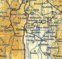
Al-Dawwara (Arabic: الدوّارة) was a Palestinian Arab village in the Safad Subdistrict. It was depopulated during the 1948 War on May 25, 1948 by the Palmach's First Battalion of Operation Yiftach. It was located 27 km northeast of Safad, bordering three rivers that flowed into lake al-Hula: the al-Hasbani, Banyas, and Dan rivers.
In 1945 the village had a population of 1,100 (this figure included 400 Jewish residents of the Kibbutzim ‘Amir and Sde Nehemia).
History
Al-Dawwara was located on flat terrain, and faced Mount Herrmon (Jabal al-Shaykh) to the northeast. It was near the confluence of three rivers that flowed into Lake Hula: the al-Hasbani, Banyas, and Dan rivers and a road linked it to a highway that led to Safad.[4]
British Mandate era
According to the 1931 census of Palestine, the entire population was Muslim except for one Christian[5] and the residents were employed mostly in agriculture, growing gram, vegetables, and citrus.[4]
In 1944/45 a total of 68 dunums was allocated to the growing of citrus fruits and bananas and 281 dunums was allocated to cereals. A total of 2,135 dunums were irrigated or used for orchards.[6] while 52 dunams was built-up (urban) area.[7]
The older houses in the village was separated by narrow alleys and mostly made of adobe and some with basalt stones.[4]
1948, aftermath
On receiving news of an imminent attack on the village by Operation Yiftach, many villagers fled on May 25, 1948, but some sources have indicated that some military force in practice was used to drive out the Arabs from the village.[4]
Today there are few remnants of Al-Dawwara except for some stones near a fish pond and today the area is a notable fish hatchery. Kibbutz ‘Amir was established in 1939 about 0.5 km west of the site, and Sde Nechemya in 1940 to the northwest.[4]
References
- ↑ Department of Statistics, 1945, p. 9
- ↑ Government of Palestine, Department of Statistics. Village Statistics, April, 1945. Quoted in Hadawi, 1970, p. 69.
- ↑ Morris, 2004, p. xvi, village #14. Also gives causes of depopulation.
- 1 2 3 4 5 Khalidi, 1992, pp. 444-445
- ↑ Mills, 1932, p. 106
- ↑ Government of Palestine, Department of Statistics. Village Statistics, April, 1945. Quoted in Hadawi, 1970, p. 118
- ↑ Government of Palestine, Department of Statistics. Village Statistics, April, 1945. Quoted in Hadawi, 1970, p. 168
Bibliography
- Department of Statistics (1945). Village Statistics, April, 1945. Government of Palestine.
- Hadawi, Sami (1970). Village Statistics of 1945: A Classification of Land and Area ownership in Palestine. Palestine Liberation Organization Research Centre.
- Khalidi, Walid (1992). All That Remains:The Palestinian Villages Occupied and Depopulated by Israel in 1948. Washington D.C.: Institute for Palestine Studies. ISBN 0-88728-224-5.
- Mills, E., ed. (1932). Census of Palestine 1931. Population of Villages, Towns and Administrative Areas. Jerusalem: Government of Palestine.
- Morris, Benny (2004). The Birth of the Palestinian Refugee Problem Revisited. Cambridge University Press. ISBN 978-0-521-00967-6.
External links
- Welcome To al-Dawwara
- Al-Dawwara, Villages of Palestine