Al-Nahr
| al-Nahr | |
|---|---|
 al-Nahr | |
| Arabic | النهر |
| Name meaning | In 1881, the place was named Kahweh, meaning "the coffee shop"[1] |
| Also spelled | an-Nahr |
| Subdistrict | Acre |
| Coordinates | 33°00′25.42″N 35°08′28.58″E / 33.0070611°N 35.1412722°ECoordinates: 33°00′25.42″N 35°08′28.58″E / 33.0070611°N 35.1412722°E |
| Palestine grid | 163/268 |
| Area | 5,261[2] dunams |
| Date of depopulation | 21 May 1948[3] |
| Cause(s) of depopulation | Military assault by Yishuv forces |
| Current localities | Ben Ami,[4] Kabri |
al-Nahr (Arabic: النهر) was a Palestinian village 14 km northeast of Acre. It was depopulated in May 1948 after a military assault carried out by the Carmeli Brigade as part of the Israel Defense Forces's Operation Ben-Ami. Immediately after the assault the village of al-Nahr was razed.[5][6]
History
The twin villages of Al-Nahr and nearby al-Tall were both sites of ancient settlements atop the tel of Kabri. Recent excavations indicate habitation back to the sixth millennium BC.[7]
Ottoman era
In the Ottoman period, the village appeared under the name of El Qahweh in Pierre Jacotin´s map from 1799.[8] In 1875, the French explorer Victor Guérin visited the village, which he called El Kahoueh. He found it to have 120 inhabitants, all Muslims.[9] In 1881 the Palestine Exploration Fund's Survey of Western Palestine described the village, then named El Kahweh, as a "stone village, containing about 250 Moslems, [] situated on the plain, surrounded by figs, olives, mulberries, and pomegranates; there is a spring and flowing stream at this village."[10]
British Mandate era
In villagers of Al-Nahr were Muslim, and lived principally of agriculture and animal husbandry.[11] In 1944/45 it had a population of 610 Arabs, with 5,261 dunams of land.[2] A total of 2,066 dunums was used for citrus and bananas, 1,094 dunums were allotted to cereals, 1,937 dunums were irrigated or used for orchards, of which 30 dunums were planted in olive trees,[11][12] while 28 dunams were built-up land.[13]
1948 war and aftermath
On March 27, 1948, hundreds of armed villagers and units of the Arab Liberation Army attacked a Jewish convoy near Kabri, killing forty-nine Jews. Six Arabs were also killed in the battle. Two months later the commander of Operation Ben-Ami gave operational orders given that day were to "attack with the aim of capturing, the villages of Kabri, Umm al Faraj and Al-Nahr, to kill the men [and] and to destroy and set fire to the villages."[6][14] Benvenisti states that "the orders were carried out to the letter", while Morris writes that a number of villagers were apparently executed.[6][15]
The Israeli kibbutz of Kabri makes use of village land.[11] The settlement of Ben Ami, named after the fallen commander of an attack on nearby Nahariyya, was also established on the village land.[11] In 1992, the village site was described as "Only two houses remain, and one of them is partially destroyed. A tall date-palm tree grows on the village site, which is overgrown by wild grasses, a few cactuses, and fig trees. The cemetery, on the western side of the village contains one identifiable grave. The nearby Fawwara spring has been fenced in and declared private property."[11]
See also
References
- ↑ Palmer, 1881, p. 43
- 1 2 Government of Palestine, Department of Statistics. Village Statistics, April, 1945. Quoted in Hadawi, 1970, p. 41
- ↑ Morris, 2004, p. xvii village #82
- ↑ Morris, 2004, (third printing 2006), p. xx village 152
- ↑ Morris, 2004, (third printing 2006), p 253
- 1 2 3 Benvenisti, 2000, pp. 138-139
- ↑ Stern, E., Lewinson-Gilboa, A., Avriam, J. (1993). The New Encyclopedia of Archaeological Excavations in the Holy Land. 3. Jerusalem: Israel Exploration Society & Carta, Simon and Schuster. pp. 839–841. ISBN 0-13-276312-5.
- ↑ Karmon, 1960, p. 160
- ↑ Guérin, 1880, p. 31
- ↑ Conder and Kitchener, 1881, SWP I, p. 146
- 1 2 3 4 5 Khalidi, 1992, pp. 27-28
- ↑ Government of Palestine, Department of Statistics. Village Statistics, April, 1945. Quoted in Hadawi, 1970, p. 81
- ↑ Government of Palestine, Department of Statistics. Village Statistics, April, 1945. Quoted in Hadawi, 1970, p. 131
- ↑ Morris, 2004, pp. 253, 347.
- ↑ Morris, 2004, p. 254.
Bibliography
- Barron, J. B., ed. (1923). Palestine: Report and General Abstracts of the Census of 1922. Government of Palestine.
- Benveniśtî, Mêrôn (2000). Sacred landscape: the buried history of the Holy Land since 1948. University of California Press. ISBN 978-0-520-23422-2.
- Conder, Claude Reignier; Kitchener, H. H. (1881). The Survey of Western Palestine: Memoirs of the Topography, Orography, Hydrography, and Archaeology. 1. London: Committee of the Palestine Exploration Fund.
- Guérin, Victor (1880). Description Géographique Historique et Archéologique de la Palestine (in French). 3: Galilee, pt. 2. Paris: L'Imprimerie Nationale.
- Hadawi, Sami (1970). Village Statistics of 1945: A Classification of Land and Area ownership in Palestine. Palestine Liberation Organization Research Center.
- Karmon, Y. (1960). "An Analysis of Jacotin's Map of Palestine" (PDF). Israel Exploration Journal. 10 (3,4): 155–173; 244–253.
- Khalidi, Walid (1992). All That Remains: The Palestinian Villages Occupied and Depopulated by Israel in 1948. Washington D.C.: Institute for Palestine Studies. ISBN 0-88728-224-5.
- Mills, E., ed. (1932). Census of Palestine 1931. Population of Villages, Towns and Administrative Areas. Jerusalem: Government of Palestine.
- Morris, Benny (2004). The Birth of the Palestinian Refugee Problem Revisited. Cambridge University Press. ISBN 0-521-00967-7.
- Morris, Benny, (second edition 2004 third printing 2006) The Birth Of The Palestinian Refugee Problem Revisited, Cambridge University Press, ISBN 0-521-00967-7
- Palmer, E. H. (1881). The Survey of Western Palestine: Arabic and English Name Lists Collected During the Survey by Lieutenants Conder and Kitchener, R. E. Transliterated and Explained by E.H. Palmer. Committee of the Palestine Exploration Fund.
External links
- Welcome to al-Nahr
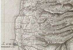
- Survey of Western Palestine, Map 3: IAA, Wikimedia commons
- Hussein Mubaraki: Because They Wanted the Land, WREMEA, May–June 2008