Auja al-Hafir
| Auja al-Hafir | |
|---|---|
 | |
| Arabic | عوجة الحفير |
| Also spelled | El Audja[1] |
| Subdistrict | Beersheba |
| Coordinates | 30°52′56″N 34°23′38″E / 30.88222°N 34.39389°ECoordinates: 30°52′56″N 34°23′38″E / 30.88222°N 34.39389°E |
| Population | 48 (1948)[2] + 3,500 'Azazme[3] |
| Date of depopulation | 1967-06-10[4] |
| Cause(s) of depopulation | Military assault by Yishuv forces |
| Current localities | Nessana |
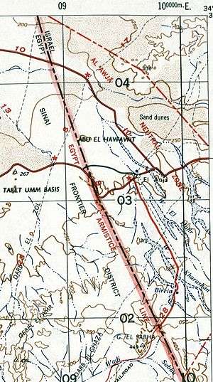
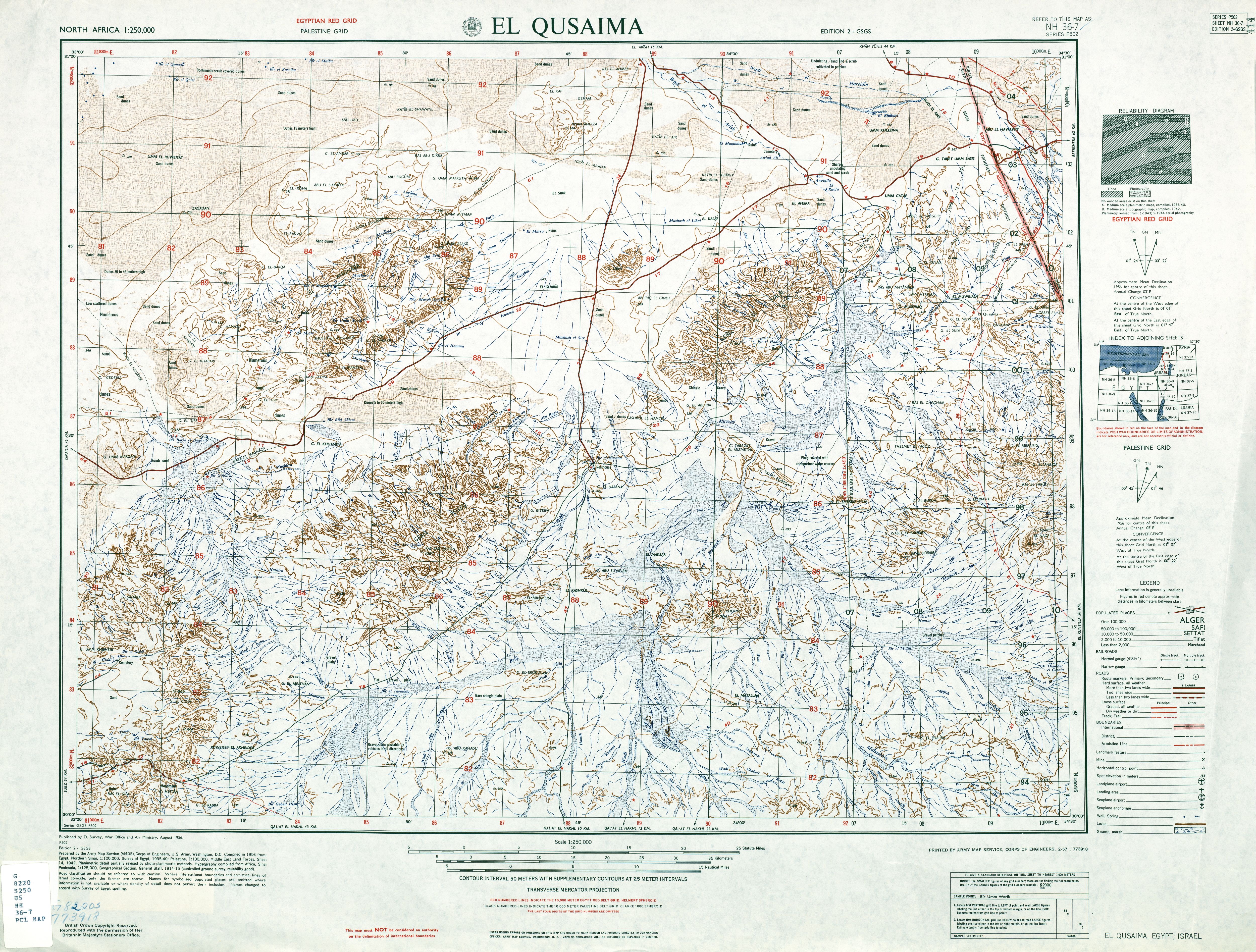
Auja al-Hafir, also Auja, was an ancient road junction close to water wells[5] in the western Negev and eastern Sinai. It was the traditional grazing land of the 'Azazme tribe. The border crossing between Egypt and Ottoman/British Palestine, about 60 km (37 mi) south of Gaza, was situated there. Today it is the site of Nitzana and the Ktzi'ot military base in the Southern District of Israel.
Etymology
Other sources name the locality el-Audja, 'Uja al-Hafeer, El Auja el Hafir and variations thereof. A‘waj means "bent" in Arabic, and "Al-Auja" is a common name for meandering streams (the Yarkon River in Israel and a smaller stream near Jericho on the West Bank both are called Al-Auja in Arabic). "Hafir" means a water reservoir built to catch runoff water at the base of a slope; in Sudan it can also mean a drainage ditch.
Ancient history
Pottery remains found in the area date back to the 2nd century BC. and are associated with the traces of massive foundations of an unknown building probably of Nabatean construction. The area appears to have remained under the Nabatean sphere of influence, outwith the Hasmonaean and Herodian Kingdoms, until AD 105 when Trajan annexed the Nabataean Kingdom.[6] A large rectangular hill-top fort probably dates from the 4th century AD. A church and associated buildings have been dated as having been built before AD 464.[7] Auja al-Hafir was struck by the great plague which swept the Eastern Mediterranean around AD 541.[8] During the 1930s a large number of papyri, dating from the 6th and 7th century, were found. One of which is from the local Arab governor granting Christian inhabitants freedom of worship on payment of the appropriate tax.[9] After 700 AD the town appears to have lost its settled population, possibly due to changing rainfall patterns.[10]
Modern history
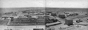
The Ottoman Empire built a police station in 1902. Before World War I it was the site of a military base.[11] From 1905 to 1915 there were built a railroad and a large administrative centre together with administrators apartment building.[12] In the middle of January, 1915, a Turkish Army force of 20,000 entered Sinai by way of El Auja on an unsuccessful expedition against the Suez Canal.[13] At this time most of the dressed stone was taken from the ancient buildings for building work in Gaza.[10]
According to the 1931 census Auja al-hafir had a population of 29 inhabitants, all Muslims.[14]
The local population were not involved in the disturbances of 1929 and 1936 but there was some disorder in the summer of 1938.[15]
At the start of the 1936 disturbances the British Mandate authorities used Auja as a concentration camp for arrested Palestinian Arab leaders including Awny Abdul Hadi. It was also used to hold Jewish Communists who were being deported. The prisoners were later transferred to the army base at Sarafand.[16]
The central route across the desert to the Suez Canal crossed from El Auja to Ismailia, until 1948 this was the only paved road between Palestine and Egypt.[17] During the British Mandate of Palestine it was part of the District of Beersheba.[18] During the British Mandate the location was a prison camp.[19]
According to the United Nations Partition Plan for Palestine, the area was designated as part of the Arab state. In 1948 the Egyptian Army used the area as a military base.[19] In the Battle of 'Auja, a campaign of the 1948 Arab–Israeli War, it was captured by the 89th Mechanized Commando Battalion, which had an English-speaking platoon of volunteers from England, Germany, the Netherlands, Rhodesia, South Africa, and the U.S.[20]
As a result of the 1949 Armistice Agreements, the area around the village, known as the al-Auja Zone, became a 145 km2 demilitarized zone (DMZ), with compliance monitored by the United Nations Truce Supervision Organization (UNTSO). On 28 September 1953 the Israeli army established a fortified settlement, Ktzi'ot, overlooking the al-Auja junction. The first name given to this Nahal outpost was Giv'at Rachel.[21] Despite a recent request for compliance with the armistice, Israel re-militarized the area on September 21, 1955. Israel continued to occupy the area until after its withdrawal from Sinai and Gaza, which ended the 1956 Suez Crisis. After this, and until the Six-Day War, the DMZ and the border were monitored by the United Nations Emergency Force. Israel has controlled the area since 1967 where it has a large military base and detention camp.
See also
References
- ↑ El Audja on www.citymaphq.com
- ↑ Encyclopedia of the Palestine Problem Archived July 5, 2008, at the Wayback Machine. by Issa Nakhleh, Chapter 12, Part 4 of 4
- ↑ Burns, Lieutenant-General E.L.M. (1962) Between Arab and Israeli. George G. Harrap. Pages 92, 93
- ↑ Israel Districts on statoids.com
- ↑ Glossary of Israeli Parties and Personalities - 1948-1981 published by the Jerusalem Centre for Public Affairs
- ↑ Palesyine Exploration Quarterly (April 1941). The Negev, or Southern Desert of Palestine by George E. Kirk. London. Page 62.
- ↑ PEQ. Page 64.
- ↑ PEQ. Page 66.
- ↑ PEQ. Pages 61, 67. Digs between 1933 and 1938 led by Mr. H. Dunscombe Colt.
- 1 2 PEQ. Page 67.
- ↑ Archaeological Encyclopedia of the Holy Land by Shimon Avraham Negev, p 367
- ↑ Naburiya Synagogue and Nitzana Farm by Yaakov Skolnik published 2007-10-04, 17:01 by ynetnews.com
- ↑ MacMunn, Lieut.-General Sir George (1928) Military Operations. Egypt and Palestine. From the outbreak of war with Germany to June 1917. HMSO. Pages 34,35.
- ↑ Mills, 1932, p. 7
- ↑ PEQ. Page 69.
- ↑ Farago, Ladislas (1936) Palestine on the Eve. Wyman and sons, London. pp.56,57.
- ↑ Neff, Donald (1988) Warriors at Suez. Eisenhower takes America into the Middle East in 1956. Amana Books. ISBN 0671410105. Page 112. "Control of the 145 square kilometer zone of El Auja, called Nitzana in Hebrew, was imperative for an attack across the sandy wastes of north-central Sinai. The zone centered on an important road junction, with roads leading north to the coast and west to the Suez Canal, the only paved road directly connecting Palestine and Egypt at the time."
- ↑ Passport Palestine: Visit a Cyber Palestine city, town or village Archived July 7, 2011, at the Wayback Machine.
- 1 2 Nizzana, Beersheba at planetware.com
- ↑ Overseas volunteers in Israel's War of Independence Internet Edition 2007 Jerusalem No. 5763 Author: Dr. Yaacov Markovitzky with contributions from Zipporah Porath, Eddy Kaplansky and Joe Woolf. Translation from the Hebrew: Moshe Kohn. Page 32
- ↑ Morris, Benny (1993) Israel's Border Wars, 1949 - 1956. Arab Infiltration, Israeli Retaliation, and the Countdown to the Suez War. Oxford University Press, ISBN 0-19-827850-0. Page 356.
Bibliography
- Israel Unit in Neutral Zone, Strategic Village Occupied, The Times, September 21, 1955, page 8.
- Ending Strife in Auja Zone, Egypt Accepts U.N. Plan, Mr. Hammarskjöld's Statement, The Times, January 25, 1956, page 8.
External links
- Nitzana (Auja El-Hafir) Memorial Board For The 1948 Independence War Fighters In The Negev
- P. Colt. No. 60 - A Bilingual Entagion From The Year 54 AH / 674 CE
- Australian War Memorial AWM Collection Record: P02041.015
- Australian War Memorial AWM Collection Record: P02041.008
- Detailed map of 1953 with Al Āwja Neutral Zone