Nasir ad-Din, Tiberias
| Nasir ad-Din | |
|---|---|
 Nasir ad-Din | |
| Arabic | نصر الدين |
| Name meaning | from personal name[1] |
| Also spelled | Nasr ad-Din, Nasir al-Din |
| Subdistrict | Tiberias |
| Coordinates | 32°46′42.93″N 35°31′24.30″E / 32.7785917°N 35.5234167°ECoordinates: 32°46′42.93″N 35°31′24.30″E / 32.7785917°N 35.5234167°E |
| Palestine grid | 199/242 |
| Population | 90[2] (1945) |
| Area | 4,185 (together with Al-Manara)[2] dunams |
| Date of depopulation | 12 and 23 April 1948[3] |
| Cause(s) of depopulation | Military assault by Yishuv forces |
| Secondary cause | Influence of nearby town's fall |
| Tertiary cause | Fear of being caught up in the fighting |
| Current localities | Residential areas of Tiberias |
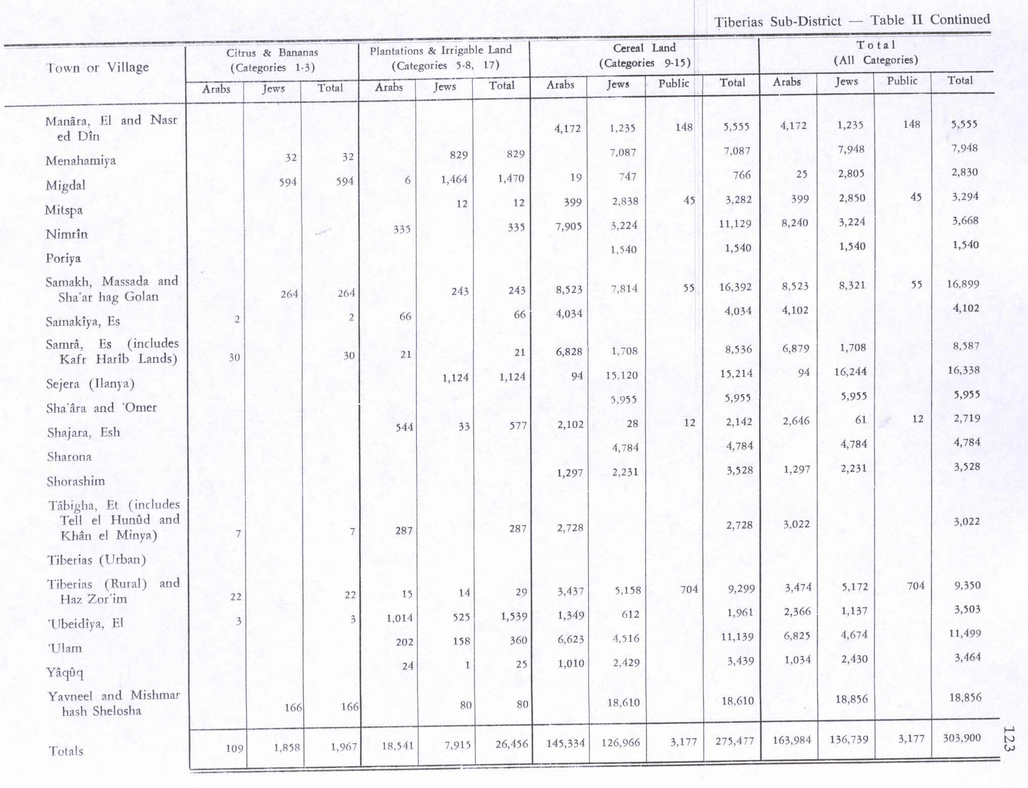
Nasir ad-Dīn (Arabic: نصر الدين) was a small Palestinian Arab village 3 kilometers (1.9 mi) southwest of Tiberias, on the crest of a slope that overlooks the Sea of Galilee. The village had several springs to the east, south, and southeast. In the 1931 British census 179 people lived there,[4][5] decreasing to 90 in a 1945 census. Nasir ad-Din and nearby al-Manara were in the same jurisdiction with 4,185 dunams of land, most of which was allocated to cereals.
History
Nasir ad-Din is named after a shrine dedicated to Nasir ad-Din, an Ayyubid general who died while fighting the Crusaders and buried to the north of the village, according to local legend. A kilometer to the west is the shrine for another Muslim soldier who died fighting the Crusaders, named Sheikh al-Qaddumi.[5]
In the 1922 census of Palestine, conducted by the British Mandate authorities, Nasir al Din had a population of 109; all Muslims,[6] increasing in the 1931 census to 179, still all Muslims, in 35 houses.[4]
During the British Mandate in Palestine, most of Nasir ad-Din's houses were scattered north-south, with no particular village plan. The inhabitants worked in agriculture and animal breeding.[5]
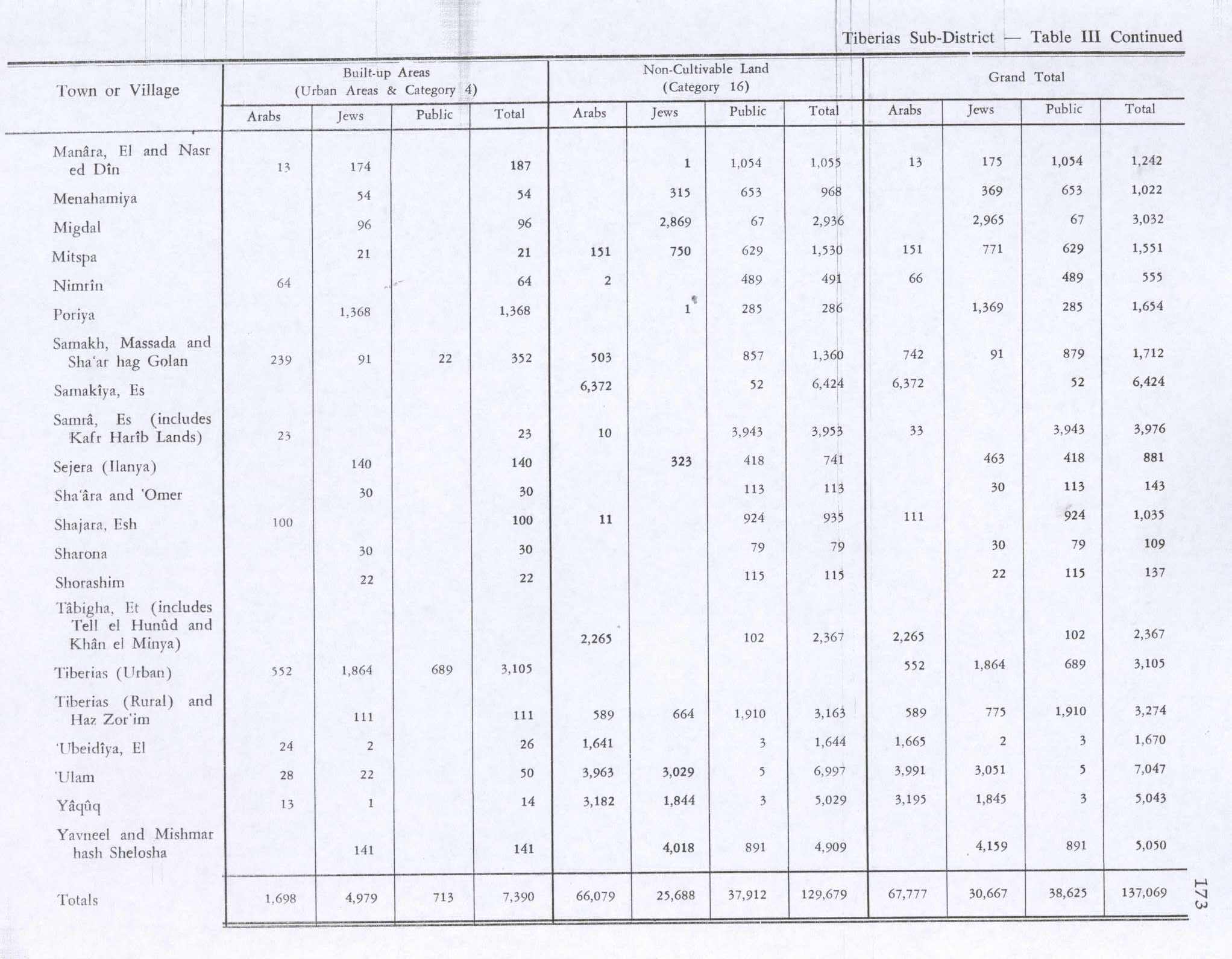
In 1945 the population consisted of 90 Arabs, and together with the people of Al-Manara they had 4,185 dunams of land.[2] Of this, 4,172 dunams of land were used for cereals,[7] while 13 dunams were classified as built-up (urban) area.[8]
1948 War
On April 12, 1948, the 12th battalion of Israel's Golani Brigade captured Nasir ad-Din to cut off Tiberias from major Arab centers to the west (Nazareth and Lubya). The skirmish lasted four hours because the Haganah encountered unexpected local resistance, but eventually most of the inhabitants fled to Tiberias or Lubya — British troops escorted villagers to Lubya. During the battle 22 Arabs were killed, six were wounded, and three were captured.[9] The civilian deaths included seven men, at least one women, and a number of children. Two Haganah troops were also wounded. The capture and killing in Nasir ad-Din was a decisive factor for the flight of Arabs from Tiberias, and was a major demoralizing factor for Arab forces. All the houses were destroyed, and residents that remained were expelled on April 23.[10]
See also
References
- ↑ Palmer, 1881, p. 131
- 1 2 3 Government of Palestine, Department of Statistics. Village Statistics, April, 1945. Quoted in Hadawi, 1970, p. 72
- ↑ Morris, 2004, p. xvii, village #97. Also gives causes of depopulation.
- 1 2 Mills, 1932, p. 84
- 1 2 3 Khalidi, 1992, p. 534
- ↑ Barron, 1923, Table XI, Sub-district of Tiberias, p. 39
- ↑ Government of Palestine, Department of Statistics. Village Statistics, April, 1945. Quoted in Hadawi, 1970, p. 123
- ↑ Government of Palestine, Department of Statistics. Village Statistics, April, 1945. Quoted in Hadawi, 1970, p. 173
- ↑ Morris, 2004, p. 183
- ↑ Morris, 1987, p. xv, 71. Quoted in Khalidi, 1992, p. 534
Bibliography
- Barron, J. B., ed. (1923). Palestine: Report and General Abstracts of the Census of 1922. Government of Palestine.
- Hadawi, Sami (1970). Village Statistics of 1945: A Classification of Land and Area ownership in Palestine. Palestine Liberation Organization Research Center.
- Khalidi, Walid (1992). All That Remains: The Palestinian Villages Occupied and Depopulated by Israel in 1948. Washington D.C.: Institute for Palestine Studies. ISBN 0-88728-224-5.
- Mills, E., ed. (1932). Census of Palestine 1931. Population of Villages, Towns and Administrative Areas. Jerusalem: Government of Palestine.
- Morris, Benny (2004). The Birth of the Palestinian Refugee Problem Revisited. Cambridge University Press. ISBN 978-0-521-00967-6.
- Palmer, E. H. (1881). The Survey of Western Palestine: Arabic and English Name Lists Collected During the Survey by Lieutenants Conder and Kitchener, R. E. Transliterated and Explained by E.H. Palmer. Committee of the Palestine Exploration Fund.
External links
- Welcome to Nasir-al-Din
- Survey of Western Palestine, Map 6: IAA, Wikimedia commons
- Nasir al-Din, from Khalil Sakakini Cultural Centre