Raml Zayta
| Raml Zayta | |
|---|---|
 | |
 Raml Zayta | |
| Arabic | رمل زيتة |
| Also spelled | Raml Zeita (Khirbat Qazaza) |
| Subdistrict | Tulkarm |
| Coordinates | 32°26′6″N 34°56′12″E / 32.43500°N 34.93667°ECoordinates: 32°26′6″N 34°56′12″E / 32.43500°N 34.93667°E |
| Palestine grid | 145/203 |
| Population | 140[1] (1945) |
| Date of depopulation | 15 March 1948 |
| Current localities | Sde Yitzhak,[2] Chadera[2] |
Raml Zayta (Arabic: رمل زيتة, Raml Zeitâ), also Khirbet Qazaza, was a Palestinian Arab village located 15 km northwest of Tulkarm.[3]
History
British Mandate era
In the 1931 census of Palestine it was counted with Zeita, Tulkarm, and together they had a population 1165, all Muslim, in a total of 237 houses.[4]
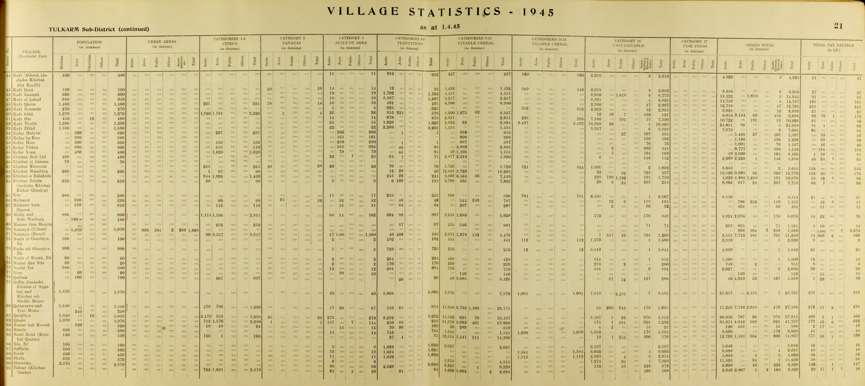
In 1945, the village had a population of 140, with a total of 14,837 dunams of land.[1][5] The land ownership of the village before occupation in dunams:[5]
| Owner | Dunams |
|---|---|
| Arab | 12,720 |
| Jewish | 1,453 |
| Public | 664 |
| Total | 14,837 |
Types of land use in dunams in the village in 1945:[6][7]
| Land Usage | Arab | Jewish | Public |
|---|---|---|---|
| Citrus and bananas | 126 | 4 | - |
| Irrigated and plantation | 27 | 4 | - |
| Cereal | 12,554 | 1,441 | 111 |
| Urban | - | - | - |
| Cultivable | 12,707 | 1,449 | 111 |
| Non-cultivable | 13 | 4 | 553 |
1948, and aftermath
According to Rosemarie Esber, the village was depopulated on 15 March 1948 during the 1948 Palestine war.[8] Benny Morris lists it as one of the villages for which the causes and date of depopulation are unknown.[9]
Esber, in an interview with a refugee from Raml Zaita, Zakiya Abu Hammad, writes that according to his memories, Yishuv forces had besieged the village for about two weeks, causing a lack of food: "[The Jews] started going into people's homes and forcing them out. They told us, "You either leave or we'll kill you." Some people were killed on the roads, as they abandoned their homes... They followed us. Those who were lucky, escaped with their lives, others did not." The villages were then forced out of their town and the surrounding villagers.[8]
According to Walid Khalidi writing in 1992, an Arab family is still living in the village in one of the original houses.[2]
References
- 1 2 Department of Statistics, 1945, p. 21
- 1 2 3 Khalidi, 1992, p. 561
- ↑ Khalidi, 1992, p. 560
- ↑ Mills, 1932, p. 58
- 1 2 Government of Palestine, Department of Statistics. Village Statistics, April, 1945. Quoted in Hadawi, 1970, p. 76
- ↑ Government of Palestine, Department of Statistics. Village Statistics, April, 1945. Quoted in Hadawi, 1970, p. 127
- ↑ Government of Palestine, Department of Statistics. Village Statistics, April, 1945. Quoted in Hadawi, 1970, p. 177
- 1 2 Esber, 2008, p. 297
- ↑ Morris, 2004, p. xvi, village #183
Bibliography
- Department of Statistics (1945). Village Statistics, April, 1945. Government of Palestine.
- Esber, Rosemarie M. (2008). Under the Cover of War, The Zionist Expulsions of the Palestinians. Arabicus Books & Media. ISBN 978-0-9815131-7-1.
- Hadawi, Sami (1970). Village Statistics of 1945: A Classification of Land and Area ownership in Palestine. Palestine Liberation Organization Research Center.
- Khalidi, Walid (1992). All That Remains: The Palestinian Villages Occupied and Depopulated by Israel in 1948. Washington D.C.: Institute for Palestine Studies. ISBN 0-88728-224-5.
- Mills, E., ed. (1932). Census of Palestine 1931. Population of Villages, Towns and Administrative Areas. Jerusalem: Government of Palestine.
- Morris, Benny (2004). The Birth of the Palestinian Refugee Problem Revisited. Cambridge University Press. ISBN 978-0-521-00967-6.
External links
- Welcome To Raml Zayta, Palestine Remembered
- Survey of Western Palestine, Map 8: IAA, Wikimedia commons
- Raml Zayta, from the Khalil Sakakini Cultural Center