Al-Mazar, Haifa
| Al-Mazar | |
|---|---|
 Al-Mazar | |
| Subdistrict | Haifa |
| Coordinates | 32°40′56.4″N 34°57′52.2″E / 32.682333°N 34.964500°ECoordinates: 32°40′56.4″N 34°57′52.2″E / 32.682333°N 34.964500°E |
| Palestine grid | 147/232 |
| Population | 210[1] (1945) |
| Date of depopulation | July 15, 1948[2] |
| Cause(s) of depopulation | Military assault by Yishuv forces |
| Current localities | 'En Karmel |
Al-Mazar was a Palestinian Arab village located 4 kilometers (2.5 mi) northeast of al-Sarafand.[3] In 1945, it had a population of 210.
History
The village name Mazar, which is Arabic for "shrine", "a place one visits", was probably meant to commemorate the many people who were killed and buried there in the wars against the Crusaders.[4]
British Mandate period
In the British Mandate of Palestine period, in the 1922 census of Palestine ‘’Al Mazar’’ had a population of 134; all Muslims.[5] In the 1931 census, Al-Mazar was counted together with Khirbat Al-Manara, Ijzim and Qumbaza. The total population was 2,160; 88 Christians, 2,082 Muslims, in a total of 442 houses.[6]
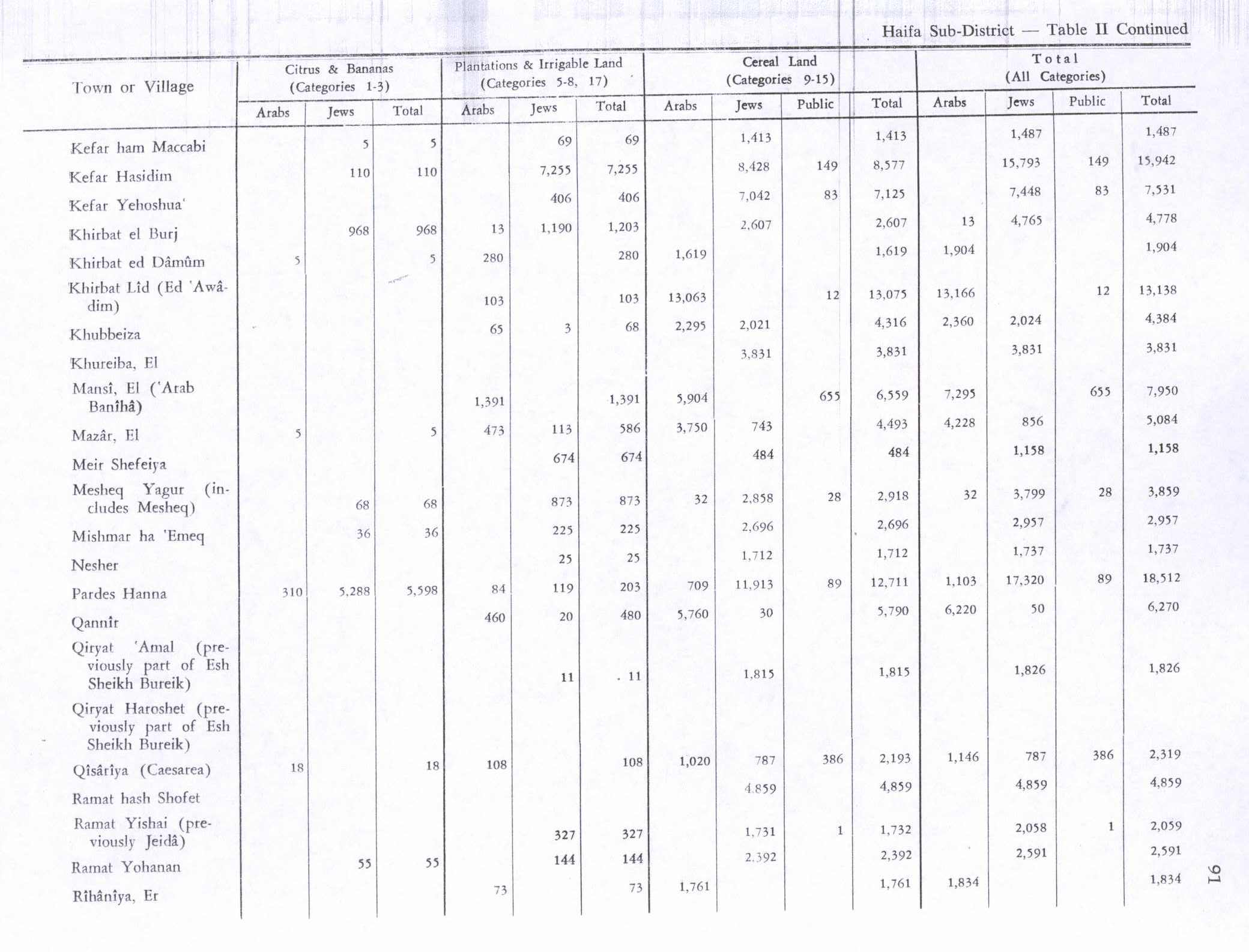
By 1945 the population was 210, all Muslims[1] with a total of 7,976 dunams of land.[7] Of this, 5 dunams were for citrus and bananas, 473 were plantations or irrigable land, 3,750 were for cereals,[8] while 39 dunams were classified built-up, (urban), land.[9]
1948, and aftermath
The village was first raided by the Israel Forces (IDF) on May 17 during the 1948 Arab-Israeli war, with the aim of "rendering [the village] unworthy of use."[3] The IDF encountered only 10-20 Arabs, who ran away, and the troops proceeded to "burn what could be burned."[3] Within days of the IDF's withdrawal, some of the villagers had returned, Arab militants and civilians.[3][10] The village was permanently depopulated as a result of another IDF military assault in mid-July 1948.[10]
Shaykh Yahia/Ahya shrine
The shrine was located on the lower slopes of a hill.[11] In 1881, E. H. Palmer described the name as possibly coming from St. John of Tyre, who was noted in this direction in 1187.[12] Ahya is also a name for John the Baptist.[13]
The shrine was surveyed by Ronen and Olami in 1964/5. They found a two roomed structure, facing east-west. The eastern room seemed the oldest; it was a domed rectangular room made of kurkar stone, where the surface were coated with plaster containing Byzantine pottery fragments. The western room was built of limestone.[14]
The shrine has now been destroyed, and the area has been converted into orchards.[11]
References
- 1 2 Department of Statistics, 1945, p. 14
- ↑ Morris, 2004, p. xviii, village #169. Also gives cause of depopulation
- 1 2 3 4 Morris, 2004, p. 248
- ↑ Khalidi, 1992, p.178
- ↑ Barron, 1923, Table XI, Sub-district of Haifa, p. 33
- ↑ Mills, 1932, p. 91
- ↑ Government of Palestine, Department of Statistics. Village Statistics, April, 1945. Quoted in Hadawi, 1970, p. 48
- ↑ Government of Palestine, Department of Statistics. Village Statistics, April, 1945. Quoted in Hadawi, 1970, p. 91
- ↑ Government of Palestine, Department of Statistics. Village Statistics, April, 1945. Quoted in Hadawi, 1970, p. 141
- 1 2 Morris, 2004, p. 438
- 1 2 Petersen, 2001, p. 216
- ↑ de Vogüé, 1860, p. 445; as noted in Palmer, 1881, p. 116
- ↑ Palmer, 1881, p. 116
- ↑ Ronen and Olami, 1978, as given in Petersen, 2001, p. 216
Bibliography
- Barron, J. B., ed. (1923). Palestine: Report and General Abstracts of the Census of 1922. Government of Palestine.
- Department of Statistics (1945). Village Statistics, April, 1945. Government of Palestine.
- Hadawi, Sami (1970). Village Statistics of 1945: A Classification of Land and Area ownership in Palestine. Palestine Liberation Organization Research Center.
- Khalidi, Walid (1992). All That Remains: The Palestinian Villages Occupied and Depopulated by Israel in 1948. Washington D.C.: Institute for Palestine Studies. ISBN 0-88728-224-5.
- Mills, E., ed. (1932). Census of Palestine 1931. Population of Villages, Towns and Administrative Areas (PDF). Jerusalem: Government of Palestine.
- Morris, Benny (2004). The Birth of the Palestinian Refugee Problem Revisited. Cambridge University Press. ISBN 978-0-521-00967-6.
- Palmer, E. H. (1881). The Survey of Western Palestine: Arabic and English Name Lists Collected During the Survey by Lieutenants Conder and Kitchener, R. E. Transliterated and Explained by E.H. Palmer. Committee of the Palestine Exploration Fund.
- Petersen, Andrew (2001). A Gazetteer of Buildings in Muslim Palestine (British Academy Monographs in Archaeology). 1. Oxford University Press. ISBN 978-0-19-727011-0.
- Ronen, Avraham. Olami, Ya'aqov.(1978): (in Hebrew): Atlit map, Archaeological Survey of Israel. (p.63-65)
- Vogüé, de, Melchior (1860). Les églises de la Terre Sainte.
External links
- Welcome To al-Mazar
- Survey of Western Palestine, Map 5: IAA, Wikimedia commons
- al-Mazar, from the Khalil Sakakini Cultural Center