Winter Garden, Florida
| Winter Garden, Florida | |
|---|---|
| City | |
|
Downtown Winter Garden on the West Orange Trail, with Plant Street at left | |
| Motto: "A charming little city with a juicy past."[1] | |
 Location in Orange County and the state of Florida | |
| Coordinates: 28°33′37″N 81°35′3″W / 28.56028°N 81.58417°WCoordinates: 28°33′37″N 81°35′3″W / 28.56028°N 81.58417°W | |
| Country |
|
| State |
|
| County | Orange |
| Incorporated (town) | 1908 |
| Government | |
| • Mayor | John Rees (Nonpartisan) |
| • City Manager | Mike Bollhoefer |
| Area[2] | |
| • Total | 15.6 sq mi (40.4 km2) |
| • Land | 15.4 sq mi (39.9 km2) |
| • Water | 0.2 sq mi (0.5 km2) |
| Elevation | 125 ft (38 m) |
| Population (2010) | |
| • Total | 34,568 |
| • Density | 2,200/sq mi (860/km2) |
| Time zone | Eastern (EST) (UTC-5) |
| • Summer (DST) | EDT (UTC-4) |
| ZIP codes | 34777, 34778, 34787 |
| Area code(s) | 407 |
| FIPS code | 12-78250[3] |
| GNIS feature ID | 0293423[4] |
| Website |
www |

Winter Garden is a city located 14 miles (23 km) west of downtown Orlando in western Orange County, Florida, United States. It is part of the Orlando–Kissimmee–Sanford, Florida Metropolitan Statistical Area. Winter Garden's population as of the 2010 census was 34,568.[5]
Geography


Winter Garden is located at 28°33′37″N 81°35′3″W / 28.56028°N 81.58417°W (28.560328, -81.584069).[6]
According to the United States Census Bureau, the city has a total area of 15.6 square miles (40.4 km2), of which 15.4 square miles (39.9 km2) is land and 0.19 square miles (0.5 km2) (1.28%) is water.[7]
Winter Garden is bordered on the south by the town of Windermere, on the east by the city of Ocoee, on the west by the town of Oakland and on the north by Lake Apopka.
Topography
The terrain is characterized by a gentle to moderately sloping topography. Winter Garden has the highest elevation spot in Orange County. The highest elevation is 222 feet (68 m) in NAVD 88 (North American Vertical Datum) located in the southwest corner of the city South near the county line with Lake County. The lowest elevation in the city is 64 feet (20 m) near Lake Apopka.
Climate
Winter Garden has a warm and humid subtropical climate, and there are two major seasons each year. One of those seasons is hot and rainy, lasting from May until October (roughly coinciding with the Atlantic hurricane season). The other is a cooler season (November through March) that brings more moderate temperatures and less frequent rainfall. The area's warm and humid climate is caused primarily by its low elevation and its position relatively close to the Tropic of Cancer, and much of its weather is affected by the movement of the Gulf Stream.
Demographics
| Historical population | |||
|---|---|---|---|
| Census | Pop. | %± | |
| 1910 | 351 | — | |
| 1920 | 1,021 | 190.9% | |
| 1930 | 2,023 | 98.1% | |
| 1940 | 3,060 | 51.3% | |
| 1950 | 3,503 | 14.5% | |
| 1960 | 5,513 | 57.4% | |
| 1970 | 5,153 | −6.5% | |
| 1980 | 6,789 | 31.7% | |
| 1990 | 9,745 | 43.5% | |
| 2000 | 14,351 | 47.3% | |
| 2010 | 34,568 | 140.9% | |
| Est. 2015 | 40,356 | [8] | 16.7% |
As of the census[3] of 2000, there were 14,351 people, 5,380 households, and 3,663 families residing in the city. The population density was 1,190.2 inhabitants per square mile (459.4/km²). There were 5,861 housing units at an average density of 486.1 per square mile (187.6/km²). The racial makeup of the city was 76.60% White, 13.25% African American, 0.36% Native American, 0.99% Asian, 0.05% Pacific Islander, 6.45% from other races, and 2.31% from two or more races. Hispanic or Latino of any race were 17.50% of the population.
There were 5,380 households out of which 33.2% had children under the age of 18 living with them, 48.8% were married couples living together, 14.4% had a female householder with no husband present, and 31.9% were non-families. 25.2% of all households were made up of individuals and 9.7% had someone living alone who was 65 years of age or older. The average household size was 2.60 and the average family size was 3.11.
In the city the population was spread out with 25.9% under the age of 18, 9.0% from 18 to 24, 31.3% from 25 to 44, 19.5% from 45 to 64, and 14.2% who were 65 years of age or older. The median age was 37.1 years. For every 100 females there were 91.9 males. For every 100 females age 18 and over, there were 88.8 males.
The median income for a household in the city was $41,858. About 10.1% of families and 12.0% of the population were below the poverty line, including 19.7% of those under age 18 and 9.4% of those age 65 or over.
Neighborhoods
|
|
Arts and culture
Points of interest


- Luther F. Tilden House
- West Orange Trail
- Winter Garden Downtown Historic District
- Winter Garden Heritage Museum
- Winter Garden Historic Residential District
- Central Florida Railroad Museum
- Garden Theatre
Shopping
Historic downtown Winter Garden contains a collection of restaurants, shops, and cafés, as well as two museums and a performing arts venue.
To the south, Winter Garden Village provides an array of chain retail and dining establishments. The 1,100,000 square feet (100,000 m2) open-air shopping center, located along Daniels Road just north of SR 429, is anchored by a Super Target, a Best Buy, and a Lowe's.[10]
Infrastructure
Transportation
State Road 50 (W. Colonial Dr) bisects the city into northern and southern sections. The portion south of State Road 50, formerly occupied by orange groves and farmland, has recently been the site of the development of numerous large-scale communities, including Johns Lake Pointe, Stoneybrook West, Stonecrest, Westfield, and Wintermere Pointe. A disparity exists between these new affluent residents, many of whom have moved from South Florida, Tampa Bay, Jacksonville, Pennsylvania and the New York metropolitan area, and longtime residents, many of whom are much less well-off.
The toll road Western Beltway (SR 429) was completed in late 2006 and links I-4 near mile marker 58 in Osceola County with Florida's Turnpike at Winter Garden. Other major roads through Winter Garden include County Road 535 and County Road 545. CR 535 (also called Winter Garden - Vineland Road) begins at SR 50 and bisects the southern half of the city, proceeding south to Windermere, Lake Buena Vista and Walt Disney World, where it becomes State Road 535. CR 545 (also called Avalon Road) begins at SR 50 and proceeds south along the western edge of Winter Garden and along the border between Orange and Lake counties. This area remains mostly rural but is quickly developing because of the nearby toll road. CR 545 currently ends at US 192 in Kissimmee at the border to Osceola County.
References
- ↑ "City of Winter Garden, Florida". City of Winter Garden, Florida. Retrieved September 2, 2012.
- ↑ "Winter Garden Economic Development". The city of Winter Garden website. Retrieved 2009-10-29.
- 1 2 "American FactFinder". United States Census Bureau. Retrieved 2008-01-31.
- ↑ "US Board on Geographic Names". United States Geological Survey. 2007-10-25. Retrieved 2008-01-31.
- ↑ "Profile of General Population and Housing Characteristics: 2010 Demographic Profile Data (DP-1): Winter Garden city, Florida". U.S. Census Bureau, American Factfinder. Retrieved September 21, 2012.
- ↑ "US Gazetteer files: 2010, 2000, and 1990". United States Census Bureau. 2011-02-12. Retrieved 2011-04-23.
- ↑ "Geographic Identifiers: 2010 Demographic Profile Data (G001): Winter Garden city, Florida". U.S. Census Bureau, American Factfinder. Retrieved September 21, 2012.
- ↑ "Annual Estimates of the Resident Population for Incorporated Places: April 1, 2010 to July 1, 2015". Retrieved July 2, 2016.
- ↑ "Census of Population and Housing". Census.gov. Retrieved June 4, 2015.
- ↑
External links
| Wikimedia Commons has media related to Winter Garden, Florida. |
- City of Winter Garden official website
- Winter Garden, Florida at City-Data.com
Municipalities and communities of Orange County, Florida, United States | ||
|---|---|---|
| Cities | 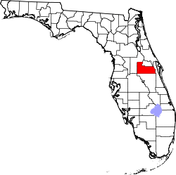 | |
| Towns | ||
| CDPs |
| |
| Unincorporated communities | ||
| Footnotes | ‡This populated place also has portions in an adjacent county or counties | |
| Attractions |
|  |
|---|---|---|
| Colleges and universities | ||
| Media |
| |
| Airports | ||
| Counties | ||
| Cities and towns 25k+ | ||
| Cities and towns 10k–25k | ||
‡ This populated place is included in the Orlando–Deltona–Daytona Beach, FL Combined Statistical Area. See also: | ||
