Okaloosa County, Florida
| Okaloosa County, Florida | |||
|---|---|---|---|
|
The Okaloosa County courthouse in March 2008 | |||
| |||
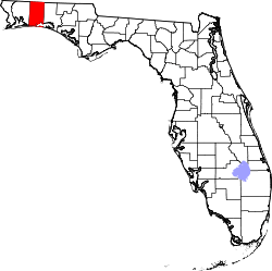 Location in the U.S. state of Florida | |||
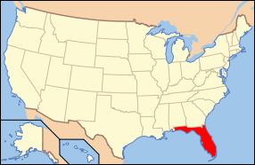 Florida's location in the U.S. | |||
| Founded | June 13, 1915 | ||
| Seat | Crestview | ||
| Largest community | Wright | ||
| Area | |||
| • Total | 1,082 sq mi (2,802 km2) | ||
| • Land | 930 sq mi (2,409 km2) | ||
| • Water | 152 sq mi (394 km2), 14.0% | ||
| Population (est.) | |||
| • (2015) | 198,664 | ||
| • Density | 502/sq mi (194/km²) | ||
| Congressional district | 1st | ||
| Time zone | Central: UTC-6/-5 | ||
| Website |
www | ||


Okaloosa County is a county located in the northwestern portion of the U.S. state of Florida, extending from the Gulf of Mexico to the Alabama state line. As of the 2010 census, the population was 180,822.[1] Its county seat is Crestview.[2]
Okaloosa County is included in the Crestview-Fort Walton Beach-Destin, FL Metropolitan Statistical Area.
History
Okaloosa County was created by an act passed June 3, 1915.[3] Okaloosa is a Choctaw word meaning "black water". "Oka" means water, and "lusa" is black in the Choctaw language.
Geography
According to the U.S. Census Bureau, the county has a total area of 1,082 square miles (2,800 km2), of which 930 square miles (2,400 km2) is land and 152 square miles (390 km2) (14.0%) is water.[4] Fort Walton Beach and three United States Air Force bases, (Duke Field in the North and Eglin AFB and Hurlburt Field are in the south).
Adjacent counties
- Covington County, Alabama - north
- Walton County, Florida - east
- Santa Rosa County, Florida - west
- Escambia County, Alabama - northwest
National protected areas
- Choctawhatchee National Forest (part)
- Gulf Islands National Seashore (part)
State Parks and Forests
- Blackwater River State Forest:189,594 acres spanning Okaloosa and neighboring Santa Rosa County.[5]
- Fred Gannon Rocky Bayou State Recreation Area: 357 acres of sand pine forest along Choctawhatchee Bay. The park provides facitities for camping, hiking, fishing, and canoeing. It is located five miles east of Niceville on State Road 20.[6]
- Henderson Beach State Park: 1.3 miles of sugar sand beach along the Gulf of Mexico. The park provides facilities for camping, RV-ing, and picnicking, as well as a pavilion and boardwalk. It is located just east of downtown Destin on U.S. 98.[7]
Demographics
| Historical population | |||
|---|---|---|---|
| Census | Pop. | %± | |
| 1920 | 9,360 | — | |
| 1930 | 9,897 | 5.7% | |
| 1940 | 12,900 | 30.3% | |
| 1950 | 27,533 | 113.4% | |
| 1960 | 61,175 | 122.2% | |
| 1970 | 88,187 | 44.2% | |
| 1980 | 109,920 | 24.6% | |
| 1990 | 143,776 | 30.8% | |
| 2000 | 170,498 | 18.6% | |
| 2010 | 180,822 | 6.1% | |
| Est. 2015 | 198,664 | [8] | 9.9% |
| U.S. Decennial Census[9] 1790-1960[10] 1900-1990[11] 1990-2000[12] 2010-2015[1] | |||
As of the census[13] of 2000, there were 170,498 people, 66,269 households, and 46,520 families residing in the county. The population density was 182 people per square mile (70/km²). There were 78,593 housing units at an average density of 84 per square mile (32/km²). The racial makeup of the county was 83.41% White, 9.10% Black or African American, 0.60% Native American, 2.47% Asian, 0.14% Pacific Islander, 1.33% from other races, and 2.96% from two or more races. 4.28% of the population were Hispanic or Latino of any race.
There were 66,269 households out of which 33.10% had children under the age of 18 living with them, 56.20% were married couples living together, 10.20% had a female householder with no husband present, and 29.80% were non-families. 23.50% of all households were made up of individuals and 7.50% had someone living alone who was 65 years of age or older. The average household size was 2.49 and the average family size was 2.94.
In the county the population was spread out with 24.70% under the age of 18, 9.60% from 18 to 24, 31.10% from 25 to 44, 22.40% from 45 to 64, and 12.10% who were 65 years of age or older. The median age was 36 years. For every 100 females there were 102.20 males. For every 100 females age 18 and over, there were 101.50 males.
The median income for a household in the county was $41,474, and the median income for a family was $47,711. Males had a median income of $30,977 versus $21,961 for females. The per capita income for the county was $20,918. About 6.60% of families and 8.80% of the population were below the poverty line, including 12.70% of those under age 18 and 6.50% of those age 65 or over.
Education
The county's public schools come under the Okaloosa County School District.
Libraries
Okaloosa County is served by the Okaloosa County Public Library Cooperative.
- Robert L.F. Sikes Library
- Destin Library
- Fort Walton Beach Library
- Mary Esther Public Library
- Niceville Library
- Valparaiso Community Library
Transportation
Airports
Surface Transportation
Okaloosa County Transit operates bus service in the county.[14]
Politics
Okaloosa County is one of the most conservative counties in Florida. Incumbent George W. Bush won the county in 2004 with 78% of the popular vote and in 2008 the Republican candidate John McCain polled 72%.[15]
| Year | Republican | Democratic | Other |
|---|---|---|---|
| 2012 | 74.0% | 24.7% | 1.3% |
| 2008 | 71.8% | 27.0% | 1.2% |
| 2004 | 77.7% | 21.6% | .8% |
| 2000 | 73.7% | 24.0% | 2.3% |
Communities
Cities
Towns
Unincorporated communities
- Baker
- Blackman
- Campton
- Deerland
- Eglin AFB
- Escambia Farms
- Garden City
- Holt
- Lake Lorraine
- Milligan
- Ocean City
- Okaloosa Island
- Seminole
- Svea
- Wright
- Whynn Haven Beach
- Florosa
- Villa Tasso
- Timpoochee
See also
References
- 1 2 "State & County QuickFacts". United States Census Bureau. Retrieved February 14, 2014.
- ↑ "Find a County". National Association of Counties. Archived from the original on May 31, 2011. Retrieved 2011-06-07.
- ↑ Hutchinson, Leonard Patrick, "History of the Playground Area of Northwest Florida", Great Outdoors Publishing Co., St. Petersburg, Florida, 1st ed., 1961, no Library of Congress card number, no ISBN, page 41.
- ↑ "US Gazetteer files: 2010, 2000, and 1990". United States Census Bureau. 2011-02-12. Retrieved 2011-04-23.
- ↑ McGovern, Bernie (2011). Florida Almanac 2012. Pelican Publishing Company. p. 186. ISBN 9781589808461.
- ↑ McGovern, Bernie (2011). Florida Almanac 2012. Pelican Publishing Company. p. 214. ISBN 9781589808461.
- ↑ McGovern, Bernie (2011). Florida Almanac 2012. Pelican Publishing Company. p. 214. ISBN 9781589808461.
- ↑ "County Totals Dataset: Population, Population Change and Estimated Components of Population Change: April 1, 2010 to July 1, 2015". Retrieved July 2, 2016.
- ↑ "U.S. Decennial Census". United States Census Bureau. Archived from the original on May 11, 2015. Retrieved June 16, 2014.
- ↑ "Historical Census Browser". University of Virginia Library. Retrieved June 16, 2014.
- ↑ "Population of Counties by Decennial Census: 1900 to 1990". United States Census Bureau. Retrieved June 16, 2014.
- ↑ "Census 2000 PHC-T-4. Ranking Tables for Counties: 1990 and 2000" (PDF). United States Census Bureau. Retrieved June 16, 2014.
- ↑ "American FactFinder". United States Census Bureau. Archived from the original on September 11, 2013. Retrieved 2011-05-14.
- ↑ http://rideoct.org/index.html
- ↑ "2008 US Presidential Election Results by County - USATODAY.com". Content.usatoday.com. 2008-11-10. Retrieved 2010-07-22.
External links
| Wikimedia Commons has media related to Okaloosa County, Florida. |
Government links/Constitutional offices
- Okaloosa County Board of County Commissioners
- Okaloosa County Clerk of Court
- Okaloosa County Supervisor of Elections
- Okaloosa County Property Appraiser
- Okaloosa County Sheriff's Office
- Okaloosa County Tax Collector
- Okaloosa County Census
Special districts
Judicial branch
- Okaloosa County Clerk of Courts
- Public Defender, 1st Judicial Circuit of Florida serving Escambia, Santa Rosa, Okaloosa, and Walton counties
- Office of the State Attorney, 1st Judicial Circuit of Florida
- Circuit and County Court for the 1st Judicial Circuit of Florida
Tourism links
Media links
 |
Escambia County, Alabama | Covington County, Alabama | | |
| Santa Rosa County | |
Walton County | ||
| ||||
| | ||||
| Gulf of Mexico |
Municipalities and communities of Okaloosa County, Florida, United States | ||
|---|---|---|
| Cities | | |
| Towns | ||
| CDPs | ||
| Unincorporated communities | ||

Coordinates: 30°40′N 86°35′W / 30.67°N 86.59°W