Florida Keys
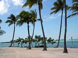
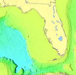
The Florida Keys are a coral cay archipelago located off the southern coast of Florida, forming the southernmost portion of the continental United States. They begin at the southeastern coast of the Florida peninsula, about 15 miles (24 km) south of Miami, and extend in a gentle arc south-southwest and then westward to Key West, the westernmost of the inhabited islands, and on to the uninhabited Dry Tortugas. The islands lie along the Florida Straits, dividing the Atlantic Ocean to the east from the Gulf of Mexico to the northwest, and defining one edge of Florida Bay. At the nearest point, the southern part of Key West is just 90 miles (140 km) from Cuba. The Florida Keys are between about 23.5 and 25.5 degrees North latitude.
The climate of the Keys is defined as tropical savanna according to Köppen climate classification. More than 95 percent of the land area lies in Monroe County, but a small portion extends northeast into Miami-Dade County, such as Totten Key. The total land area is 137.3 square miles (356 km2). As of the 2010 census the population was 73,090 with an average density of 532.34 per square mile (205.54/km2),[1] although much of the population is concentrated in a few areas of much higher density, such as the city of Key West, which has 32% of the entire population of the Keys. The US Census population estimate for 2014 is 77,136.
The city of Key West is the county seat of Monroe County. The county consists of a section on the mainland which is almost entirely in Everglades National Park, and the Keys islands from Key Largo to the Dry Tortugas.
History
Early history
The Keys were originally inhabited by Calusa and Tequesta Native Americans, and were later found and charted by Juan Ponce de León in 1513. De León named the islands Los Martires ("The Martyrs"), as they looked like suffering men from a distance.[2] "Key" is derived from the Spanish word cayo, meaning small island. For many years, Key West was the largest town in Florida, and it grew prosperous on wrecking revenues. The isolated outpost was well located for trade with Cuba and the Bahamas, and was on the main trade route from New Orleans. Improved navigation led to fewer shipwrecks, and Key West went into a decline in the late nineteenth century.
Overseas Railway
The Keys were long accessible only by water. This changed with the completion of Henry Flagler's Overseas Railway in the early 1910s. Flagler, a major developer of Florida's Atlantic coast, extended his Florida East Coast Railway down to Key West with an ambitious series of over-sea railroad trestles. Three hurricanes disrupted the project in 1906, 1909, and 1910.
Labor Day Hurricane of 1935
One of the worst hurricanes to strike the U.S. made landfall near Islamorada in the Upper Keys on Labor Day, Monday, September 2. Winds were estimated to have gusted to 200 mph (320 km/h), raising a storm surge more than 17.5 feet (5.3 m) above sea level that washed over the islands. More than 400 people were killed, though some estimates place the number of deaths at more than 600.
The Labor Day Hurricane is one of only three hurricanes to make landfall at Category 5 strength on the U.S. coast since reliable weather records began (about 1850). The other storms were Hurricane Camille (1969) and Hurricane Andrew (1992).
In 1935, new bridges were under construction to connect a highway through the entire Keys. Hundreds of World War I veterans working on the roadway as part of a government relief program were housed in non-reinforced buildings in three construction camps in the Upper Keys. When the evacuation train failed to reach the camps before the storm, more than 200 veterans perished. Their deaths caused anger and charges of mismanagement that led to a Congressional investigation.
The storm also ended the 23-year run of the Overseas Railway; the damaged tracks were never rebuilt, and the Overseas Highway (U.S. Highway 1) replaced the railroad as the main transportation route from Miami to Key West.[3]
Seven Mile Bridge
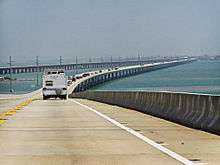
One of the longest bridges when it was built, the Seven Mile Bridge connects Knight's Key (part of the city of Marathon in the Middle Keys) to Little Duck Key in the Lower Keys. The piling-supported concrete bridge is 35,862 ft (10,931 m) or 6.79 miles (10.93 km) long. The current bridge bypasses Pigeon Key, a small island that housed workers building Henry Flagler's Florida East Coast Railway in the 1900s, that the original Seven Mile Bridge crossed. A 2.2-mile (3.5 km) section of the old bridge remains for access to the island, although it was closed to vehicular traffic on March 4, 2008. The aging structure has been deemed unsafe by the Florida Department of Transportation. Costly repairs, estimated to be as much as $34 million, were expected to begin in July 2008. Monroe County was unable to secure a $17 million loan through the state infrastructure bank, delaying work for at least a year. On June 14, 2008, the old bridge section leading to Pigeon Key was closed to fishing as well. While still open to pedestrians — walking, biking and jogging — if the bridge were closed altogether, only a ferry subsidized by FDOT and managed by the county would transport visitors to the island.
Overseas Highway
After the destruction of the Keys railway by the Labor Day Hurricane of 1935, the railroad bridges, including the Seven Mile Bridge, were converted to automobile roadways. This roadway, U.S. Highway 1, became the Overseas Highway that runs from Key Largo south to Key West. Today this unique coastal highway allows those in automobiles to travel through the tropical islands of the Florida Keys and view exotic plants and animals found nowhere else on the US mainland. The Overseas Highway allows travelers access to the largest coral reef chain in the United States that runs through the Florida Keys.
Cuban exiles
Following the Cuban Revolution, many Cubans fled to South Florida. Key West traditionally had strong links with its neighbor ninety miles south by water, and large numbers of Cubans settled there. The Keys still attract Cubans leaving their home country, and stories of "rafters" coming ashore are not uncommon.
Conch Republic
In 1982, the United States Border Patrol had established a roadblock and inspection points on US Highway 1, stopping all northbound traffic returning to the mainland at Florida City, to search vehicles for illegal drugs and illegal immigrants. The Key West City Council repeatedly complained about the roadblocks, which were a major inconvenience for people traveling from Key West, and hurt the Keys' important tourism industry.
After various unsuccessful complaints and attempts to get a legal injunction against the blockade failed in federal court in Miami, on April 23, 1982, Key West mayor Dennis Wardlow and the city council declared the independence of the city of Key West, calling it the "Conch Republic". After one minute of secession, he (as "Prime Minister") surrendered to an officer of the Key West Naval Air Station (NAS), and requested one billion ($1,000,000,000) dollars in "foreign aid".[4]
The stunt succeeded in generating great publicity for the Keys' plight, and the inspection station roadblock was removed. It also provided a new source of revenue for the Keys, and the Conch Republic has participated in later protests.
Geology
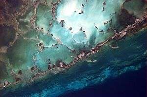
The Florida Keys are the exposed portions of an ancient coral reef. The northernmost island arising from the ancient reef formation is Elliott Key, in Biscayne National Park. North of Elliott Key are several small transitional keys, composed of sand built up around small areas of exposed ancient reef. Further north, Key Biscayne and places north are barrier islands, built up of sand.[5]
The Florida Keys have taken their present form as the result of the drastic changes in sea level associated with recent glaciations or ice ages. Beginning some 130,000 years ago the Sangamonian Stage raised sea levels to approximately 25 feet (7.5 m) above the current level. All of southern Florida was covered by a shallow sea. Several parallel lines of reef formed along the edge of the submerged Florida plateau, stretching south and then west from the present Miami area to what is now the Dry Tortugas. This reef formed the Key Largo limestone that is exposed on the surface from Soldier Key (midway between Key Biscayne and Elliott Key) to the southeast portion of Big Pine Key and the Newfound Harbor Keys. The types of coral that formed Key Largo limestone can be identified on the exposed surface of these keys.
Starting about 100,000 years ago the Wisconsin glaciation began lowering sea levels, exposing the coral reef and surrounding marine sediments. By 15,000 years ago the sea level had dropped to 300 to 350 feet (110 m) below the contemporary level. The exposed reefs and sediments were heavily eroded. Acidic water, which can result from decaying vegetation, dissolves limestone. Some of the dissolved limestone redeposited as a denser cap rock, which can be seen as outcrops overlying the Key Largo and Miami limestones throughout the Keys. The limestone that eroded from the reef formed oolites in the shallow sea behind the reef, and together with the skeletal remains of bryozoans, formed the Miami limestone that is the current surface bedrock of the lower Florida peninsula and the lower keys from Big Pine Key to Key West. To the west of Key West the ancient reef is covered by recent calcareous sand.[6]
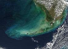
Just offshore of the Florida Keys along the edge of the Florida Straits is the Florida Reef (also known as the Florida Reef Tract). The Florida Reef extends 270 km from Fowey Rocks just east of Soldier Key to just south of the Marquesas Keys. It is the third-largest barrier reef system in the world.[7]
Environment
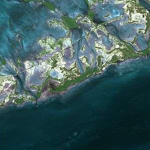
The climate and environment of the Florida Keys are closer to that of the Caribbean than the rest of Florida, though unlike the Caribbean's volcanic islands, the Keys were built by plants and animals. The Upper Keys islands are composed of sandy-type accumulations of limestone grains produced by plants and marine organisms. The Lower Keys are the remnants of large coral reefs, which became fossilized and exposed as sea level declined.
The natural habitats of the Keys are upland forests, inland wetlands and shoreline zones. Soil ranges from sand to marl to rich, decomposed leaf litter. In some places, "caprock" (the eroded surface of coral formations) covers the ground. Rain falling through leaf debris becomes acidic and dissolves holes in the limestone, where soil accumulates and trees root.
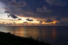 Sunset near Marathon
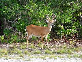 A male Key Deer on No Name Key in the lower Keys
Climate
The climate of the Florida Keys is tropical savanna (Köppen climate classification: Aw),[8] and other than some areas of coastal Miami, the Florida Keys are the only areas in Florida to have never reported a frost since settlement. There are two main "seasons": hot, wet, and humid from about June through October, and a drier and cooler season from November through May.
| Climate data for Key West Int'l, Florida (1981–2010 normals,[lower-alpha 1] extremes 1872−present)[lower-alpha 2] | |||||||||||||
|---|---|---|---|---|---|---|---|---|---|---|---|---|---|
| Month | Jan | Feb | Mar | Apr | May | Jun | Jul | Aug | Sep | Oct | Nov | Dec | Year |
| Record high °F (°C) | 90 (32) |
87 (31) |
89 (32) |
91 (33) |
93 (34) |
96 (36) |
97 (36) |
97 (36) |
95 (35) |
93 (34) |
91 (33) |
88 (31) |
97 (36) |
| Mean maximum °F (°C) | 82.0 (27.8) |
82.7 (28.2) |
84.2 (29) |
86.0 (30) |
88.6 (31.4) |
91.0 (32.8) |
92.0 (33.3) |
92.1 (33.4) |
91.1 (32.8) |
88.7 (31.5) |
85.6 (29.8) |
82.7 (28.2) |
92.6 (33.7) |
| Average high °F (°C) | 74.3 (23.5) |
76.0 (24.4) |
78.2 (25.7) |
81.3 (27.4) |
85.0 (29.4) |
87.8 (31) |
89.3 (31.8) |
89.4 (31.9) |
87.9 (31.1) |
84.5 (29.2) |
79.9 (26.6) |
76.0 (24.4) |
82.5 (28.1) |
| Daily mean °F (°C) | 69.3 (20.7) |
71.0 (21.7) |
73.2 (22.9) |
76.4 (24.7) |
80.3 (26.8) |
83.3 (28.5) |
84.5 (29.2) |
84.5 (29.2) |
83.2 (28.4) |
80.2 (26.8) |
75.8 (24.3) |
71.4 (21.9) |
77.76 (25.42) |
| Average low °F (°C) | 64.2 (17.9) |
66.0 (18.9) |
68.3 (20.2) |
71.6 (22) |
75.7 (24.3) |
78.8 (26) |
79.8 (26.6) |
79.6 (26.4) |
78.5 (25.8) |
76.0 (24.4) |
71.7 (22.1) |
66.9 (19.4) |
73.1 (22.8) |
| Mean minimum °F (°C) | 51.0 (10.6) |
53.7 (12.1) |
57.4 (14.1) |
61.9 (16.6) |
69.5 (20.8) |
73.4 (23) |
74.1 (23.4) |
73.8 (23.2) |
73.6 (23.1) |
69.1 (20.6) |
62.2 (16.8) |
54.5 (12.5) |
48.8 (9.3) |
| Record low °F (°C) | 41 (5) |
44 (7) |
47 (8) |
48 (9) |
63 (17) |
65 (18) |
68 (20) |
68 (20) |
64 (18) |
59 (15) |
49 (9) |
44 (7) |
41 (5) |
| Average rainfall inches (mm) | 2.04 (51.8) |
1.49 (37.8) |
2.05 (52.1) |
2.05 (52.1) |
3.00 (76.2) |
4.11 (104.4) |
3.55 (90.2) |
5.38 (136.7) |
6.71 (170.4) |
4.93 (125.2) |
2.30 (58.4) |
2.22 (56.4) |
39.83 (1,011.7) |
| Average rainy days (≥ 0.01 in) | 6.2 | 5.3 | 5.8 | 4.5 | 7.2 | 11.0 | 11.7 | 14.2 | 16.2 | 11.3 | 6.6 | 6.4 | 106.4 |
| Average relative humidity (%) | 76.0 | 74.3 | 73.0 | 70.1 | 71.8 | 74.0 | 72.2 | 73.4 | 75.3 | 75.1 | 76.0 | 76.2 | 74.0 |
| Mean monthly sunshine hours | 249.6 | 245.4 | 308.8 | 324.6 | 340.3 | 314.0 | 325.2 | 306.6 | 269.6 | 254.7 | 230.9 | 234.5 | 3,404.2 |
| Percent possible sunshine | 75 | 77 | 83 | 85 | 82 | 77 | 78 | 76 | 73 | 71 | 70 | 71 | 77 |
| Source: NOAA (relative humidity and sun 1961−1990)[9][10][11], The Weather Channel[12] | |||||||||||||
Flora and fauna
The Florida Keys have distinctive plant and animals species, some found nowhere else in the United States, as the Keys define the northern extent of their ranges. The climate also allows many imported plants to thrive. Nearly any houseplant known to commerce, and most landscape plants of the South, can thrive in the Keys climate. Some exotic species which arrived as landscape plants now invade and threaten natural areas.
The native flora of the Keys is diverse, including members of both temperate families, such as red maple (Acer rubrum), slash pine (Pinus elliottii var. densa) and oaks (Quercus spp.), growing at the southern end of their ranges, and tropical families, including mahogany (Swietenia mahagoni), gumbo limbo (Bursera simaruba), stoppers (Eugenia spp.), Jamaican dogwood (Piscidia piscipula), and many others, which grow only as far north as 25 or 26 degrees north latitude.
Several plants that are popularly thought of as exemplifying Keys landscapes are in fact not native. These include bougainvillea, hibiscus, and papaya.
The well-known and very sour Key lime (or Mexican lime) is a naturalized species, apparently introduced from the Yucatán Peninsula of Mexico, where it had previously been introduced from Malaysia by explorers from Spain. The tree grows vigorously and has thorns, and produces golf-ball-size yellow fruit which is particularly acidic (even in highly alkaline coral soil) and uniquely fragrant. Key lime pie gets its name from the fruit.
The Keys are also home to unique animal species, including the Key deer, protected by the National Key Deer Refuge, the American crocodile, and the Key Largo woodrat. The Key Largo Woodrat is found only in the northern part of its namesake island, and is a focus of management activities in Crocodile Lake National Wildlife Refuge. About 70 miles (110 km) west of Key West is Dry Tortugas National Park, one of the most isolated and therefore well-preserved in the world. The name derives from the fact that when Spanish explorers arrived no fresh water could be found, and the small hump-shaped islands look like tortoise (tortuga in Spanish) shells from a distance.
The waters surrounding the Keys are part of a protected area known as the Florida Keys National Marine Sanctuary.
Tropical cyclones
The Keys are occasionally threatened by tropical storms and hurricanes, leading to evacuations to the mainland. Hurricane Georges, after tearing up much of the Caribbean, caused damage and extensive flooding in the Lower Keys in 1998, before making landfall in Mississippi. In 2005, Hurricanes Katrina, Rita and Wilma affected the Keys (although none made a direct hit), causing widespread damage and flooding. The most severe hurricane to hit the area was the Labor Day Hurricane of 1935, a Category 5 hurricane.
Tropical cyclones present special dangers and challenges to the entire Keys. Because no area of the islands is more than 20 feet (6.1 m) above sea level (and many are only a few feet elevation), and water surrounds the islands, nearly every neighborhood is subject to flooding as well as hurricane winds. In response, many homes in the Keys are built on concrete stilts with the first floor being not legally habitable and enclosed by breakaway walls that are not strongly attached to the rest of the house. Nonetheless, Monroe County, as reported in the Federal Register, has estimated that there are between 8,000 and 12,000 illegal enclosures inhabited by people.[13]
Because of the threat from storm surge, evacuations are routinely ordered when the National Weather Service issues a hurricane watch or warning, and are sometimes ordered for a tropical storm warning. Evacuation of the Keys depends on causeways and the two-lane highway to the mainland. Time estimates for evacuating the entire Keys range from 12 to 24 hours. Evacuation estimates are significant in emergency planning, of course, but also because they are a factor in local and state regulations for controlling development. The building permit allocation was increased in 2005 when local governments reduced estimates for evacuation.
Major islands
U.S. Highway 1, the "Overseas Highway", runs over most of the inhabited islands of the Florida Keys. The islands are listed in order from southwest to north. Mile markers are listed for keys that the Overseas Highway runs across or near.[14]
- Dry Tortugas
- Marquesas Keys
- Sunset Key
- Wisteria Island
- Key West (MM 0-4)
- Fleming Key
- Sigsbee Park (off to the north at MM 2¾)
- Stock Island (MM 5)
- Raccoon Key (off to the north at MM 5¼)
- Boca Chica Key (MM 7-8)
- Rockland Key (MM 9)
- East Rockland Key (MM 9½)
- Big Coppitt Key (MM 10)
- Geiger Key (off to the south at MM 10¾)
- Shark Key (off to the north at MM 11¼)
- Saddlebunch Keys (MM 12-16)
- Lower Sugarloaf Key (MM 17)
- Park Key (MM 18)
- Sugarloaf Key (MM 19-20)
- Cudjoe Key (MM 21-23)
- Knockemdown Key
- Summerland Key (MM 24-25)
- Ramrod Key (MM 27)
- Middle Torch Key, Big Torch Key (off to the north at MM 27¾)
- Little Torch Key (MM 28½)
- Big Pine Key (MM 30-32)
- No Name Key
- Scout Key (MM 34-35), formerly known as West Summerland Key
- Bahia Honda Key (MM 37-38)
- Ohio Key (MM 38¾), also known as Sunshine Key
- Missouri Key (MM 39¼)
- Little Duck Key (MM 39¾)
The Seven Mile Bridge (MM 40-46¾) separates the Lower Keys from the Middle Keys.
- Pigeon Key (off to the north near MM 45; access is at MM 46¾)
- Knights Key (MM 47)
- Vaca Key (MM 48-53)
- Boot Key (off to the south at MM 48; bridge closed)
- Fat Deer Key (MM 53¼-55)
- Shelter Key (off to the south at MM 53¾)
- Long Point Key (MM 56)
- Crawl Key (MM 56½)
- Grassy Key (MM 58-60)
(Knights, Vaca, Boot, Long Point, Crawl, and Grassy Keys, as well as most of Fat Deer Key, are incorporated in the city of Marathon.[15] The remaining portion of Fat Deer Key and most of Shelter Key are part of Key Colony Beach.)
The Long Key Bridge (MM 63¼-65¼) separates the Middle Keys from the Upper Keys.
- Long Key (MM 66-70), formerly known as Rattlesnake Key
- Fiesta Key (off to the north at MM 70)
- Craig Key (MM 72)
- Lower Matecumbe Key (MM 74-77)
- Lignumvitae Key
- Indian Key
- Indian Key Fill (MM 79)
- Tea Table (MM 79½)
- Upper Matecumbe Key (MM 80-83)
- Windley Key (MM 85)
- Plantation Key (MM 86-90)
(Lower Matecumbe through Plantation Keys are incorporated as Islamorada, Village of Islands. The "towns" of Key Largo, North Key Largo and Tavernier, all on the island of Key Largo, are not incorporated.)
- Key Largo (MM 91-107)
- Cross Key (MM 109-112)
All keys north of Broad Creek are in Biscayne National Park and Miami-Dade County. The following are "true" Florida Keys (exposed ancient coral reefs):
The following are "transitional keys", made of exposed ancient reef surrounded by sand.
Key Biscayne is not one of the Florida Keys, but the first of the Atlantic barrier islands.
Transportation
The main chain of Keys islands can be traveled by motor vehicles on the Overseas Highway, a 127-mile (204 km) section of U.S. 1, which runs from Key West to Fort Kent, Maine in its entirety. The highway was built parallel to the original route of the Overseas Railway, which was not rebuilt following the Labor Day hurricane of 1935. Even before the hurricane, road sections and highway bridges allowed automobile traffic to travel from Miami to Lower Matecumbe Key, where a car ferry connected with another roadway section through the Lower Keys. Following the hurricane, some of the original railway bridges were converted to carry the highway roadbeds. These bridges were used until the 1980s, when new highway bridges were built alongside. Many of the original railroad and highway bridges remain today as pedestrian fishing piers.
Public transportation
The Florida Keys has public bus transportation.
Road hazards
Despite this reconstruction, U.S. 1 was not widened on a large scale, and today most of the route consists of just two lanes. Due to their tropical climate,[16] the Florida Keys attract several hundred thousand tourists annually.[17] While some visitors arrive via Key West International Airport and Florida Keys Marathon Airport in Marathon, cruise ship or ferry from Miami, Fort Myers, or Marco Island, Florida, the vast majority of tourists drive down from the mainland on U.S. 1.[18] This influx of traffic, coupled with the two-lane nature of U.S. 1 through most of its length in the Keys, and the fact that no alternative road routes are available mean that Monroe County has the highest per capita rate of fatal automobile accidents in the state of Florida.[19]
Culture and recreation
Some residents have a separatist "Conch Republic" attitude. The major industries are fishing and tourism, including ecotourism, with many visitors scuba diving in the area's protected waters. A new ferry now takes riders between Key West and Fort Myers, due north on the mainland, along the western edge of Florida Bay.
Notes
- ↑ Mean monthly maxima and minima (i.e. the highest and lowest temperature readings during an entire month or year) calculated based on data at said location from 1981 to 2010.
- ↑ Official records for Key West were kept at the Weather Bureau in downtown from January 1871 to February 1958, and at Key West Int'l since March 1958. For more information, see ThreadEx.
References
- ↑ "State & County QuickFacts". United States Census Bureau. Retrieved December 25, 2015.
- ↑ Journal of Antonio de Herrera quoted in Goodwin-Nguyen, S (2008) Key West: A Comprehensive Guide to Florida's Southernmost City, Channel Lake, p. 19.
- ↑ about
- ↑ The Conch Republic
- ↑ U.S. National Park Service Link recovered from Internet Archive December 23, 2010
Blank, Joan Gill. 1996. Key Biscayne. Sarasota, Florida: Pineapple Press, Inc. ISBN 1-56164-096-4. P. 150. - ↑ Florida Keys Information and Florida Keys Info Online Videos for Florida Keys Travel Guide and Vacation Guides
- ↑ Florida NOAA's Coral Reef Information System Accessed December 14, 2010.
- ↑ Köppen Climate Classification Map on John Abbott College.
- ↑ "NowData - NOAA Online Weather Data". National Oceanic and Atmospheric Administration. Retrieved 2016-11-03.
- ↑ "Station Name: FL KEY WEST INTL AP". National Oceanic and Atmospheric Administration. Retrieved 2014-05-26.
- ↑ "WMO Climate Normals for KEY WEST/INTL, FL 1961–1990". National Oceanic and Atmospheric Administration. Retrieved 2014-03-10.
- ↑ "Average Weather for Key West, FL - Temperature and Precipitation". Retrieved 2010-05-18.
- ↑ "U.S. Government Printing Office". "United States Government". June 27, 2000. pp. 39276–39578.
- ↑ FDOT straight line diagrams, accessed April 2014.
- ↑ Code of ordinances, City of Marathon, Florida
- ↑ Tourism Development Council information Accessed September 27, 2007.
- ↑ Archived July 9, 2012, at the Wayback Machine.
- ↑ Monroe County Tourist Development Council Survey Accessed September 27, 2007.
- ↑ Florida Highway Patrol 2006 accident statistics Accessed September 27, 2007.
Other references
- Jeff, Ripple (1995). The Florida Keys: the Natural Wonders of an Island Paradise, Photographs by Bill Keogh, Stillwater, Minnesota: Voyageur Press. ISBN 0-89658-262-0.
- Jason Project The Story of Water Movement and Land Formation – accessed January 28, 2006.
- About the Florida Keys
- Florida Keys Fish
External links
| Wikimedia Commons has media related to Florida Keys. |
| Wikisource has the text of the 1921 Collier's Encyclopedia article Florida Keys. |
- A Gazetteer of the Florida Keys
 Florida Keys travel guide from Wikivoyage
- City of Key West
- City of Marathon
- History of the Conch Republic
- National Park Service: Dry Tortugas
- NOAA Marine Sanctuary
- Florida Keys Watershed - Florida DEP
Media
Coordinates: 24°40′01″N 81°32′39″W / 24.66694°N 81.54417°W