Palm Beach County, Florida
| Palm Beach County, Florida | |||
|---|---|---|---|
 West Palm Beach, looking northeast | |||
| |||
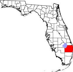 Location in the U.S. state of Florida | |||
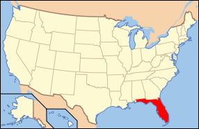 Florida's location in the U.S. | |||
| Founded | April 30, 1909 | ||
| Named for | Palm Beach | ||
| Seat | West Palm Beach | ||
| Largest city | West Palm Beach | ||
| Area | |||
| • Total | 2,383 sq mi (6,172 km2) | ||
| • Land | 1,970 sq mi (5,102 km2) | ||
| • Water | 413 sq mi (1,070 km2), 17.3% | ||
| Population (est.) | |||
| • (2015) | 1,422,789 | ||
| • Density | 722/sq mi (279/km²) | ||
| Congressional districts | 18th, 20th, 21st, 22nd | ||
| Time zone | Eastern: UTC-5/-4 | ||
| Website |
www | ||

Palm Beach County is a county located in the state of Florida, directly north of Broward County. As of the 2010 census, the population was 1,320,134,[1] making it the third-most populous county in Florida. The largest city and county seat is West Palm Beach.[2] Named after one of its oldest settlements, Palm Beach, the county was established in 1909, after being split from Dade County. The county's modern-day boundaries were established in 1963. Palm Beach County is one of the three counties in South Florida and is part of the Miami metropolitan area, which was home to an estimated 6,012,331 people at the 2015 census.
The area had been increasing in population since the late 19th century, with the incorporation of West Palm Beach in 1894 and after Henry Flagler extended the Florida East Coast Railway and built the Royal Poinciana Hotel, The Breakers, and Whitehall. In 1928, the Okeechobee hurricane struck West Palm Beach and caused thousands of deaths. Since then, a number of other tropical cyclones have impacted the area. More recently, the county acquired national attention during the 2000 presidential election, when a controversial recount occurred.
As of 2004, Palm Beach County is Florida's wealthiest county, with a per capita personal income of $44,518.[3] It leads the state in agricultural productivity, and except for real estate, agriculture is Palm Beach County's largest industry.[4]
History
Approximately 10,200 years ago, Native Americans began migrating into Florida. The tribes settling in modern-day Palm Beach County included the Ais', Calusas, Jaegas, Mayaimis, and Tequestas. An estimated 20,000 Native Americans lived in South Florida when the Spanish arrived. Their population diminished significantly by the 18th century, due to warfare, enslavement, and diseases from Europe.[5] In 1513, Juan Ponce de León, who led a European expedition to Florida earlier that year, became the first non-Native American to reach Palm Beach County, after landing in the modern day Jupiter area.[6] Among the first non-Native American residents were African Americans, many of whom were former slaves or immediate descendants of former slaves who had escaped to Florida from slave plantations located in Alabama, Georgia, and South Carolina. Runaway African slaves started coming to what was then Spanish Florida in the late 17th century and they found refuge among the Seminole Native Americans. During the Seminole Wars, these African-American slaves fought with the Seminoles against White settlers and bounty hunters.[7][8] Portions of the Second Seminole War occurred in Palm Beach County, including the Battle of Jupiter Inlet in 1838.[9]
The oldest surviving structure, the Jupiter Lighthouse, was built in 1860, after receiving authorization to the land from President Franklin Pierce in 1854.[10] During the American Civil War, Florida was a member of the Confederate States of America. To aid the cause of their state, Augustus O. Lang and James Paine removed the lighting mechanism, dimming the lighthouse and assisting their blockade runners.[11] Lang was also the first white settler in Palm Beach County. He built a palmetto shack along the eastern shore of Lake Worth in 1863 after abandoning the cause of the Confederacy.[12] After the Civil War ended, the Jupiter Lighthouse was re-lit in 1866.[11] Thirteen years later, a National Weather Service office was established at the lighthouse complex. However, the office was moved to Miami after that city's population began to rapidly grow.[13]
In October 1873, a hurricane caused a shipwreck between Biscayne Bay and the New River. The crew survived, but nearly died due to starvation because of the desolation of the area. An Act of Congress on June 20, 1874, resulted in the establishment of five houses of Houses of Refuge along the east coast of Florida from the Fort Pierce Inlet southward to Biscayne Bay. Orange Grove House of Refuge No. 3 was built near Delray Beach in 1876.[14]
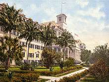
Henry Flagler, who was instrumental in the county's development in the late 19th century and early 20th century, first visited in 1892, describing the area as a "veritable paradise." Flagler subsequently purchased land on both sides of Lake Worth. Other investors followed suit, causing a small boom and bringing in existing businesses or new ones were established. The Royal Poinciana Hotel, constructed by Flagler to accommodate wealthy tourists, opened for business in February 1894. About a month later, the Florida East Coast Railway, owned by Flagler, reached West Palm Beach. On November 5, 1894, Palm Beach County's oldest city, West Palm Beach, was incorporated. In 1896, another hotel built by Flagler was opened, the Palm Beach Inn, later renamed the The Breakers.[15] He also constructed his own winter home beginning in 1900; he and his wife moved in on February 6, 1902. Flagler died there on May 20, 1913, after falling down a flight of marble stairs.
Palm Beach County was created in 1909. It was named for its first settled community, Palm Beach. The County was carved out of what was then the northern portion of Dade County, comprising part of the areas now occupied by Okeechobee and Broward counties, part of Martin and all of Palm Beach county, initially including all of Lake Okeechobee. The southernmost part of Palm Beach County was separated to create the northern portion of Broward County in 1915, the northwestern portion became part of Okeechobee County 1917 and southern Martin County was created from northernmost Palm Beach County in 1925.[16]
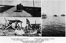
Early on September 17, 1928, the Okeechobee hurricane made landfall near West Palm Beach and crossed Lake Okeechobee shortly thereafter.[17] Storm surge left severe damage in the city of Palm Beach, and a death toll of 26.[18] In West Palm Beach, more than 1,711 homes were destroyed.[19] Further inland, wind-driven storm surge in Lake Okeechobee inundated adjacent communities, particularly Belle Glade, Pahokee, and South Bay. Hundreds of square miles were flooded, including some areas with up to 20 feet (6.1 m) of water. Numerous houses were swept away and damaged after crashing into other obstacles.[20] Flood waters did not completely subside for several weeks. At least 2,500 deaths occurred, many of whom were black migrant farmers. Damage in South Florida totaled approximately $25 million (1928 USD). In response to the storm, the Herbert Hoover Dike was constructed to prevent a similar disaster.[21] Previously, Lake Okeechobee overflowed in 1926 during the Miami hurricane, though flooding was primarily in Moore Haven in Glades County.[22] As a result of both the Okeechobee and Miami hurricanes, Palm Beach County, along with the rest of South Florida, began suffering economic turmoil and pushed the region into the Great Depression, even before the Wall Street Crash of 1929. Housing prices dropped dramatically in the county, as well as in the rest of the country.[23]
The Palm Beach International Airport (PBIA), then known as Morrison's Field, opened in 1936. After the United States entered World War II, it was converted to an Air Force Base in 1942.[24] During the war, thousands of servicemen arrived in Palm Beach County for training and supporting the war effort.[25] Following the conclusion of World War II, a number of veterans returned to the area for work, vacation, or retirement.[25] The base was closed and became a commercial airport again in 1962.[24] Migration to the county by workers, tourists, and retirees continued into the 21st century.[26]
August 28, 1949, a Category 4 hurricane struck West Palm Beach with maximum sustained winds of 150 mph (240 km/h) causing considerable damage.[27]
The area's first television station, WIRK-TV Channel 21, signed on September 13, 1953. It went off the air less than three years later. However, NBC affiliate WPTV-TV and CBS affiliate WPEC first aired in 1954 and 1955, respectively – both of which are still in existence today.[28]
Richard Paul Pavlick nearly attempted to assassinate then President-elect John F. Kennedy in Palm Beach in December 1960. The Kennedys were vacationing at La Guerida,[29] a house originally owned by Rodman Wanamaker and sold to Joseph P. Kennedy, Sr. in 1933.[30] Pavlick's anti-Catholic and anti-government views led him to stalk and plot to kill JFK.[31] A resident of New Hampshire, Pavlick loaded-up his car with sticks of dynamite and drove down to Palm Beach. Pavlick sent bizarre postcards to his hometown, which included information that coincided with the Kennedys vacation. The postmaster alerted the Secret Service to be vigilant for Pavlick's vehicle. On December 11, as Kennedy was preparing to leave for Mass, Pavlick forwent his attempt to murder Kennedy because he was with his wife, Jacqueline, and their two children.[29] On December 15, Pavlick's car, which had sticks of dynamite inside, was surrounded by police and he was arrested.[29][31] Charges against Pavolick were dropped on December 2, 1963, 10 days after Kennedy was assassinated in Dallas, Texas.[29] Additionally, a secret blast shelter built on Peanut Island during his presidency because escalating Cold War tensions.[32]
About three-quarters of Lake Okeechobee was removed from Palm Beach County in 1963 and divided up among Glades, Hendry, Martin and Okeechobee counties. This was the final change to the county's boundaries.[16]
Hurricane David struck near West Palm Beach late on September 3, 1979, with sustained winds of 100 mph (155 km/h). The storm's winds shattered windows in stores near the coast and caused property damage, including blowing the frame off the Palm Beach Jai Alai and downing the 186-foot (57-m) WJNO AM radio tower in West Palm Beach into the Intracoastal Waterway. A few roofs were torn off, and numerous buildings were flooded from over 6 inches (150 mm) of rainfall. Damage in the county reached $30 million (1979 USD), most of which was incurred to agriculture.
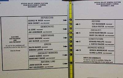
The county became the center of controversy during presidential election on November 7, 2000. Allegedly, the "butterfly ballot", designed by Palm Beach County Supervisor of Elections Theresa LePore, led to an unexpectedly large number of votes for Reform Party candidate Pat Buchanan, rather than for Democrat Al Gore. Due to the aforementioned "butterfly ballot" and the closeness of the statewide results between Gore and Texas Governor George W. Bush, manual recounts were conducted. On December 8, The Florida Supreme Court voted 4-3 to mandate manual recounts in all counties with disputed results. However, the Supreme Court of the United States overturned the decision in Bush v. Gore on December 12, allowing Florida Secretary of the State Katherine Harris to award the 25 electoral votes to Bush, as Harris's tally prior to the state-ordered recounts placed him ahead of Gore by 537 popular votes. In turn, this gave Bush victory in the national election.
Following the September 11 attacks in 2001, an FBI investigation revealed that 12 of the 19 terrorists trained or resided in Palm Beach County during the months prior to the attacks, including Ahmed al-Ghamdi,[33] Ahmed al-Haznawi,[34] Marwan al-Shehhi, Waleed and Wail Alshehri, Satam al-Suqami, Mohamed Atta,[33] and Ziad Jarrah.[34] Later that month, during the anthrax attacks, a letter containing spores of this substance was mailed to the American Media, Inc. building in Boca Raton. Three people were exposed to the anthrax, including Robert Stevens, a photo editor who died after an infection induced by the anthrax.[33]
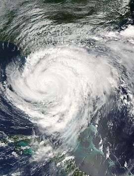
Palm Beach County was impacted by several tropical cyclones in 2004 and 2005, most severely by hurricanes Frances, Jeanne, and Wilma, which resulted in at least a few billion dollars in damage. Early on September 5, 2004, Frances made landfall in Martin County as a Category 2 hurricane with winds of 105 mph (165 km/h). Although the county recorded tropical storm-force winds, a wind gust of 91 mph (146 km/h) was observed at the Jupiter Inlet. The strong winds caused about 659,000 power outages, according to Florida Power & Light (FPL). Structural damage in Palm Beach County included 15,000 houses and 2,400 businesses. Additionally, crops suffered severely, with $70 million (2004 USD) in damage dealt to sugar cane. Six deaths occurred in Palm Beach County due to storm-related vehicle accidents or drownings.
About three weeks after Frances, Hurricane Jeanne struck near the same location as a Category 3 hurricane with winds of 120 mph (195 km/h). Despite Jeanne being more intense than Frances, the overall impact was slightly lesser. Storm surge of 2 to 4 ft (0.61 to 1.22 m) along the coast resulted in moderate beach erosion in Palm Beach County. Jeanne also brought strong winds, with a wind gust of 94 mph (151 km/h) recorded at the C-MAN station at the Lake Worth pier. Unofficially, a wind gust of 125 mph (201 km/h) was observed in West Palm Beach. FPL reported 591,300 electrical outages in the county after Jeanne. About 4,160 homes were damaged and 60 were destroyed. Severe local flooding occurred in Jupiter, Palm Beach Gardens, and rural areas of western Palm Beach County. Agricultural losses reached about $30 million. Overall, Jeanne wrought $260 million in damage, but caused no deaths.

On October 24, 2005, Hurricane Wilma made landfall near Cape Romano, Florida, as a Category 3 hurricane with winds of 120 mph (195 km/h). The storm headed northwestward and moved directly across Palm Beach County. At PBIA, sustained winds reached 82 mph (132 km/h), while a wind gust as strong as 101 mph (163 km/h) was observed. Winds damaged 52,385 Palm Beach County homes and destroyed 2,669 others.
Since Hurricane Wilma in 2005, several other tropical cyclones have impacted Palm Beach County. In August 2008, Tropical Storm Fay brought generally minor flooding, with 7 to 9 in (180 to 230 mm) of rain over the eastern portions of the county. Fay spawned an EF2 over Wellington, which deroofed stables and knocked over electrical poles and several trees at the Palm Beach Equine Clinic. Additionally, the Equine Veterinary lost more than 95% of its roof tiles and a heavy trailer was tossed about 120 ft (37 m) from its original location. An apartment building also suffered minor roof damage. About four years later, in August 2012, the outerbands of Hurricane Isaac dropped at least 15.86 in (403 mm) of rain near Lion Country Safari. The consequent flooding left neighborhoods in The Acreage, Loxahatchee, Royal Palm Beach, and Wellington, were left stranded for up to several days. One man died after crashing into a concrete wall along Interstate 95 during the storm. Overall, damage in the county totaled approximately $71.59 million (2012 USD).
Geography

According to the U.S. Census Bureau, the county has a total area of 2,383 square miles (6,170 km2), of which 1,970 square miles (5,100 km2) is land and 413 square miles (1,070 km2) (17.3%) is water.[35] It is the second-largest county in Florida by land area and third-largest by total area. Much of the water is the Atlantic Ocean and Lake Okeechobee. The county has approximately 526,000 acres (213,000 ha) of farmland.
Adjacent counties
Palm Beach County borders Martin County to the north, the Atlantic Ocean to the east, Broward County to the south, Hendry County to the west, and extends into Lake Okeechobee in the northwest, where it borders Okeechobee County and Glades County at one point in the center of the lake.
Natural areas
- Arthur R. Marshall Loxahatchee National Wildlife Refuge, a 147,392 acres (59,647 ha) refuge in Boynton Beach
- DuPuis Management Area, a 21,875 acres (8,852 ha) area of protected lands.
- J.W. Corbett Wildlife Management Area, a 60,348 acres (24,422 ha) area of protected lands.
- Jupiter Ridge Natural Area, a 271 acres (110 ha) preserve in Jupiter, Florida.
- Juno Dunes Natural Area, a 576 acres (233 ha) preserve in Juno Beach.
- Frenchman's Forest Natural Area, a 158 acres (64 ha) preserve in Palm Beach Gardens.
- Sweetbay Natural Area, a 1,094 acres (443 ha) preserve in Palm Beach Gardens.
- Royal Palm Beach Pines Natural Area, a 773 acres (313 ha) preserve in Royal Palm Beach.
- Hypoluxo Scrub Natural Area, a 97 acres (39 ha) preserve in Hypoluxo.
- Rosemary Scrub Natural Area, a 14 acres (5.7 ha) preserve in Boynton Beach.
- Seacrest Scrub Natural Area, a 54 acres (22 ha) preserve in Boynton Beach.
- Delray Oaks Natural Area a 25 acres (10 ha) prairie and xeric hammock preserve with a small strand swamp and areas of flatwoods in Delray Beach.
- Leon M. Weekes Environmental Preserve, a 12 acres (4.9 ha) preserve in Delray Beach.
In addition the county has many coral reef patches along its coastline. The county has put in a lot of effort to preserve the reefs.
Demographics
| Historical population | |||
|---|---|---|---|
| Census | Pop. | %± | |
| 1910 | 5,577 | — | |
| 1920 | 18,654 | 234.5% | |
| 1930 | 51,781 | 177.6% | |
| 1940 | 79,989 | 54.5% | |
| 1950 | 114,688 | 43.4% | |
| 1960 | 228,106 | 98.9% | |
| 1970 | 348,753 | 52.9% | |
| 1980 | 576,863 | 65.4% | |
| 1990 | 863,518 | 49.7% | |
| 2000 | 1,131,184 | 31.0% | |
| 2010 | 1,320,134 | 16.7% | |
| Est. 2015 | 1,422,789 | [36] | 7.8% |
| U.S. Decennial Census[37] 1790-1960[38] 1900-1990[39] 1990-2000[40] 2010-2015[1] | |||
2010 Census
U.S. Census Bureau 2010 Ethnic/Race Demographics:[41][42]
- White (non-Hispanic) (73.5% when including White Hispanics): 60.1% (10.8% German, 10.2% Irish, 9.4% Italian, 7.4% English, 4.7% Polish, 4.7% Russian, 2.4% French, 1.6% Scottish, 1.1% Scotch-Irish, 1.0% Dutch, 1.0% Hungarian, 0.8% Swedish, 0.7% Greek, 0.6% Norwegian, 0.6% French Canadian)[41]
- Black (non-Hispanic) (17.3% when including Black Hispanics): 16.8% (7.2% West Indian/Afro-Caribbean American [4.6% Haitian, 1.8% Jamaican, 0.2% Bahamian, 0.2% Other or Unspecified West Indian, 0.2% Trinidadian and Tobagonian, 0.1% British West Indian,] 0.8% Subsaharan African)[41][43]
- Hispanic or Latino of any race: 19.0% (3.7% Mexican, 3.3% Cuban, 3.0% Puerto Rican, 1.7% Colombian, 1.5% Guatemalan, 0.8% Dominican, 0.6% Honduran, 0.6% Peruvian, 0.5% Salvadoran)[42][44]
- Asian: 2.4% (0.7% Asian Indian, 0.4% Chinese, 0.4% Other Asian, 0.3% Filipino, 0.3% Vietnamese, 0.1% Korean, 0.1% Japanese)[41][42]
- Two or more races: 2.3%
- American Indian and Alaska Native: 0.5%
- Native Hawaiian and Other Pacific Islander: 0.1%[41][42]
- Other Races: 4.0% (0.5% Arab)[41]
In 2010, 4.5% of the population considered themselves to be of only "American" ancestry (regardless of race or ethnicity.)[41]
As of 2010, Haitians made up the largest population of immigrants, with Cuban exiled refugees coming in second, Mexicans in third, followed by Colombians in fourth place, then Jamaicans, Guatemalans, Canadians, Hondurans, ninth being Peruvians, and Brazilians being the tenth highest group of expatriates. British, Germans, and Polish, which had held spots in Palm Beach County's top 10 immigrant list of 2000, dropped off the 2010 list, which now no longer has any European countries in its top ten.[45]
There were 664,594 households out of which 24.35% had children under the age of 18 living with them, 46.28% were married couples living together, 11.68% had a female householder with no husband present, and 37.40% were non-families. 30.11% of all households were made up of individuals and 14.70% (4.02% male and 10.68% female) had someone living alone who was 65 years of age or older. The average household size was 2.39 and the average family size was 2.97.[42][46]
The age distribution is 20.4% under the age of 18, 8.0% from 18 to 24, 23.7% from 25 to 44, 26.4% from 45 to 64, and 21.6% who were 65 years of age or older. The median age was 43.5 years. For every 100 females there were 93.8 males. For every 100 females age 18 and over, there were 91.3 males.[46]
In 2010, 22.3% of the county's population was foreign born, with 43.7% being naturalized American citizens. Of foreign-born residents, 71.3% were born in Latin America, 13.6% were born in Europe, 9.2% born in Asia, 4.0% in North America, 1.8% born in Africa, and 0.1% were born in Oceania.[41]
Languages
As of 2010, 73.13% of all residents spoke English as a primary language, while 15.69% spoke Spanish, 4.03% French Creole (mainly Haitian Creole,) 1.06% French, 0.94% Portuguese, and 0.54% of the population spoke Italian. In total, 26.87% spoke languages other than English as their mother language.[47]
Economy
Companies headquartered in Palm Beach County include Office Depot, The ADT Corporation, TBC Corporation, G4S Secure Solutions, BIOMET 3i, Campus Management Corp., Cross Match Technologies, Next Era Energy, The GEO Group and Florida Crystals.
Although not headquartered in Palm Beach County there is a significant number of aerospace focused facilities operating in the northern part of the county. Aerospace companies with facilities located within the county include United Technologies, Pratt & Whitney Rocketdyne, Sikorsky Aircraft, General Dynamics, Belcan Engineering Group and Lockheed Martin. Many of these companies rank among the top 100 employers for the county. [48]
A number of shopping malls exist throughout Palm Beach County, including the Boynton Beach Mall, The Gardens Mall, Town Center at Boca Raton, CityPlace, The Mall at Wellington Green and Mizner Park.[49] Formerly, the Palm Beach and Cross County Malls operated in the county, though they closed in 1997 and 2010, respectively.
In undeveloped (central and western) Palm Beach County there is significant agricultural production, especially nurseries, truck crops (vegetables), and sugar cane.[50] Palm Beach County has been called the "Winter Vegetable Capital" of the nation.[51]
Previously W. R. Grace and Company had its headquarters in unincorporated Palm Beach County, near Boca Raton.[52] Prior to its closing, the Boca Raton headquarters had about 130 employees. On January 27, 2011 it announced it was closing the Boca headquarters and moving its administrative staff out of state along with some employees.[52][53]
Previously, American Media, publisher of the National Enquirer, was headquartered in the Boca Raton. It still maintains an office there, but moved the National Enquirer to New York in 2014.[54]
Personal income
The median income for a household in the county was $53,242, and the median income for a family was $64,445. Males had a median income of $44,324 versus $37,337 for females. The per capita income for the county was $33,610. About 8.6% of families and 12.2% of the population were below the poverty line, including 18.5% of those under age 18 and 7.7% of those aged 65 or over.[55]
Tourism
Tourists visit during these annual events:
Tourists patronize these sites:
- American Orchid Society Visitors Center and Botanical Garden
- Daggerwing Nature Center
- Gumbo Limbo Environmental Complex
- Kravis Center for the Performing Arts
- Jupiter Inlet Lighthouse
- Lion Country Safari
- Morikami Museum and Japanese Gardens, including the Roji-en Japanese Gardens
- Mounts Botanical Garden
- Norton Museum of Art
- Palm Beach Maritime Museum [56]
- Palm Beach Zoo at Dreher Park
- South Florida Science Museum
Government
The Florida Department of Corrections operates the Glades Correctional Institution in an unincorporated area in Palm Beach County near Belle Glade.[57]
County Government
The county is governed by a Board of Commissioners. The Board consists of seven commissioners, who are all elected from single-member districts. One of the commissioners is elected Mayor and one of them is elected Vice-Mayor. Commissioners serve staggered terms, and Commissioners from Districts 1, 3, 5, and 7 are elected during presidential election years, while the Commissioners from Districts 2, 4, and 6 are elected in gubernatorial election years.
Elected county officers include a Clerk of Courts and Comptroller, Sheriff, Property Appraiser, Tax Collector, and Supervisor of Elections. State officers serving the Florida judicial district include the State Attorney, and Public Defender. All positions are four year terms, requiring direct election by voters in presidential election years.
Five former county commissioners have been accused or found guilty of corruption from 2006 to 2009. A grand jury recommended a strong inspector general. This position was approved by county voters in 2010. A county judge found that the mandate covered municipal government in 2015.[58]
| Palm Beach County Officials | ||
|---|---|---|
| Position | Incumbent | |
| District 1 Commissioner | Hal R. Valeche | |
| District 2 Commissioner | Paulette Burdick | |
| District 3 Commissioner | Shelley Vana | |
| District 4 Commissioner | Steven L. Abrams | |
| District 5 Commissioner | Mary Lou Berger | |
| District 6 Commissioner | Melissa McKinlay | |
| District 7 Commissioner | Priscilla Taylor | |
| Clerk and Comptroller | Sharon R. Bock | |
| Sheriff | Ric Bradshaw | |
| Property Appraiser | Gary R. Nikolits | |
| Tax Collector | Anne M. Gannon | |
| Supervisor of Elections | Susan Bucher | |
| State Attorney | Dave Aronberg | |
| Public Defender | Carey Haughwout | |
Elections
| Year | Republican | Democratic |
|---|---|---|
| 2016 | 40.9% 272,402 | 56.2% 374,673 |
| 2012 | 41.1% 247,398 | 58.1% 349,651 |
| 2008 | 38.2% 226,037 | 61.1% 361,271 |
| 2004 | 39.1% 212,688 | 60.4% 328,687 |
| 2000 | 35.3% 152,964 | 62.3% 269,754 |
| 1996 | 33.7% 133,811 | 58.1% 230,687 |
| 1992 | 34.6% 140,350 | 46.4% 187,869 |
| 1988 | 55.5% 181,495 | 44.1% 144,199 |
| 1984 | 61.7% 186,811 | 38.3% 116,091 |
| 1980 | 56.8% 143,639 | 36.4% 91,991 |
| 1976 | 49.5% 98,236 | 48.7% 96,705 |
| 1972 | 72.3% 108,670 | 27.2% 40,825 |
| 1968 | 53.2% 62,191 | 28.1% 32,837 |
| 1964 | 53.1% 49,614 | 46.9% 43,836 |
| 1960 | 60.3% 45,337 | 39.7% 29,871 |
As of July 2015, the voter registration in the county consisted of 361,955 Democrats and 233,908 Republicans, while 246,453 people were Independents or members of a third party.[60]
Since 1992, Palm Beach County has supported a Democrat for the presidency. Prior to 1992, the county had been carried by a Republican every four years since 1948. Palm Beach County was the center of a nationwide media storm in 2000 when it appeared to have impacted the presidential election that year between eventual winner George W. Bush and Al Gore. A major source of controversy was the butterfly ballot used in Palm Beach County, a confusing ballot design which may have caused many voters to mistakenly vote for Reform Party candidate Pat Buchanan instead of Al Gore. Buchanan had an unexpectedly strong showing in the county.[61] In the end, Gore carried the county, but Bush captured the state of Florida by 537 votes after the recount was effectively halted by the Supreme Court of the United States in Bush v. Gore.
In the 2004 presidential election, President Bush garnered more votes in the county, but trailed Democrat John Kerry by 60.35%-39.05%. During the United States Senate election, Betty Castor (D) carried Palm Beach County against Republican Mel Martinez by a slightly wider margin of 22.26%.[62] In 2006, incumbent Senator Bill Nelson (D) trounced Katherine Harris (R), receiving about 72.54% of the vote. Then-Republican Charlie Crist was defeated in the county by Jim Davis (D) by 59.71%-38.28%.[63] In the 2008 presidential election, Barack Obama increased the Democratic victory margin from four years earlier and took approximately 61.08% of the vote against John McCain (R) in the county.[64]
In the 2010 gubernatorial election, Alex Sink (D) won Palm Beach County by a margin of 18.67% against Rick Scott (R). That same year, then-Independent United States Senate candidate and former Governor Crist carried Palm Beach County by just under 3,000 votes, or a margin of only 0.74%.[65] President Obama, who was re-elected in 2012, won by a smaller margin in the county, with Mitt Romney managing to receive 41.18% of the vote. During the Class I United States Senate seat election in Florida, incumbent Democrat Bill Nelson garnered 55.2% of the vote against challenger Connie Mack IV in Palm Beach County.[66] Former Governor Crist, who became a Democrat, garnered 58.8% of the vote against Governor Scott in the 2014 gubernatorial election.[67]
In the United States House of Representatives, Palm Beach County is represented by four Democrats: Patrick Murphy of the 18th district, Alcee Hastings of the 20th district, Ted Deutch of the 21st district, and Lois Frankel of the 22nd district.[67]
Transportation
Roadways
An advocacy group has criticized Palm Beach County's roadways for being dangerous for non-motorized users.[68] Local municipalities are working to increase safety, but county and state authorities have been hesitant to modify designs.[69][70]
Expressways
I-95 and Florida's Turnpike are controlled-access expressways that serve Palm Beach county. Southern Boulevard (signed SR 80/US 98), which runs east-west through central Palm Beach County, is a partial freeway from Interstate 95 in West Palm Beach to US 441/SR 7 in Wellington and Royal Palm Beach. In the late 1980s, there were plans to construct two additional expressways in Palm Beach County. One was to be an 11.5 miles (18.5 km) toll freeway from Royal Palm Beach to downtown West Palm Beach. It would have run between Belvedere Road and Okeechobee Boulevard; necessitating the destruction of several homes and churches along its path. The other proposed route was a northern extension of the Sawgrass Expressway which was to be called "University Parkway". The University Parkway would have snaked around suburban developments west of Boca Raton, Delray Beach, and Boynton Beach; its path bordering the Loxahatchee National Wildlife Refuge.[71][72] Ultimately, both expressways were canceled due to opposition from county residents.[73][74][75]
Major highways
Federal Highway:
Range Line Road:
Southern Boulevard:
Other major highways:
 A1A (Ocean Boulevard)
 Route 807/County Road 807 (Congress Ave)
 Route 809/County Road 809 (Military Trail)
 Route 710 (Bee Line Hwy)
Railroads
- Tri-Rail runs along eastern Palm Beach county, adjacent to Interstate 95 for most of its length. It has stops in Boca Raton, Delray Beach, Boynton Beach, Lake Worth, West Palm Beach, and Mangonia Park.
Airports

- Palm Beach International Airport
- Palm Beach County Park Airport
- North Palm Beach County General Aviation Airport
- Boca Raton Airport
- Belle Glade State Airport
- Palm Beach County Glades
Public transit
- PalmTran provides bus service throughout Palm Beach county.
Seaport
The Port of Palm Beach is located in Riviera Beach, where Celebration Cruise Line operates 2-day cruises to the Bahamas.
Trails
The Lake Okeechobee Scenic Trail, a segment of the Florida National Scenic Trail, passes through the County.
Education
Primary and secondary schools
All of Palm Beach County is served by the School District of Palm Beach County. As of 2006, it was the 4th largest school district in Florida and the 11th largest school district in the United States. As of August 2006, the district operated 164 schools, including 25 high schools, and, as of July 22, 2006 had an additional 33 charter schools, with seven more scheduled to open in August 2006.[76] Newsweek listed three Palm Beach County high schools in the top 50 schools in the list 1200 Top U.S. Schools - Atlantic Community High School, Suncoast High School and the Alexander Dreyfoos School of the Arts, all public magnet schools.[77] Private schools in the county include American Heritage School, Cardinal Newman High School, Jupiter Christian School, The King's Academy, The Benjamin School, Oxbridge Academy, Pope John Paul II High School, St Andrew's School and Weinbaum Yeshiva High School.
Colleges and universities
- Florida Atlantic University
- Lynn University
- Nova Southeastern University
- Palm Beach Atlantic University
- Palm Beach State College
- Keiser University [78]
- Roosevelt Junior College (closed)
Public libraries
Palm Beach County Library System operates public libraries, the main one being the Main Library on Summit Blvd.
The city of West Palm Beach operates the Mandel Public Library of West Palm Beach for its residents. Other cities, such as Boca Raton and several others, also operate public libraries for their residents
Sports
The Palm Beach Imperials are an American Basketball Association 2006 expansion franchise.
The Jupiter Hammerheads are a Single-A affiliate of the Miami Marlins, and the Palm Beach Cardinals are a Single High-A affiliate of the St. Louis Cardinals. Both teams play their games at Roger Dean Stadium in Jupiter. The St. Louis Cardinals and Miami Marlins conduct their spring training at Roger Dean Stadium in Jupiter.
Prior to the construction of Roger Dean Stadium, the Montreal Expos and Atlanta Braves held their spring training at Municipal Stadium in West Palm Beach. The West Palm Beach Expos, a Single-A affiliate of the Montreal Expos, also played their games there.
Also popular are the Florida Atlantic Owls, an NCAA Division I school that participates in Conference USA. The FAU football team play at FAU Stadium, and averaged 14,552 fans during the 2013 season.[79] The FAU basketball team plays at FAU Arena, and averaged 1,346 fans during the 2013–14 season.[80]
A newly built stadium, The Ballpark of The Palm Beaches, for spring training, which will accommodate both the Washington Nationals and Houston Astros, will make its debut in February 2017.[81]
Media
- The Palm Beach Post
- Palm Beach Daily News
- The Palm Beach Times
- New Times Broward-Palm Beach
- Sun-Sentinel
- WPTV-TV
- WPBF-TV
- WFLX
- WPEC
- WTVX
Communities


The largest city and county seat is West Palm Beach, with an estimated population of over 105,000. Additionally, the approximate urban population is 250,000, when including adjacent unincorporated neighborhoods. Boca Raton (South County), is the second largest, having a population approaching 90,000. Boynton Beach (South County), is the third largest city, with a population nearing 70,000 residents.[82]
The county has 38 municipalities in total. The municipalities are numbered corresponding to the attached image. Municipality populations are based on the 2010 Census.[83]
| # | Incorporated Community | Designation | Date incorporated | Population |
|---|---|---|---|---|
| 24 | Atlantis | City | 1959 | 2,005 |
| 2 | Belle Glade | City | April 9, 1928 | 17,467 |
| 37 | Boca Raton | City | May 26, 1925 | 84,392 |
| 30 | Boynton Beach | City | 1920 | 68,217 |
| 33 | Briny Breezes | Town | March 19, 1963 | 601 |
| 18 | Cloud Lake | Town | 1947 | 135 |
| 35 | Delray Beach | City | October 9, 1911 | 60,522 |
| 17 | Glen Ridge | Town | 1948 | 219 |
| 32 | Golf | Village | 1957 | 252 |
| 23 | Greenacres | City | May 24, 1926 | 37,573 |
| 34 | Gulf Stream | Town | 1925 | 786 |
| 16 | Haverhill | Town | 1950 | 1,873 |
| 36 | Highland Beach | Town | 1949 | 3,539 |
| 29 | Hypoluxo | Town | 1955 | 2,588 |
| 7 | Juno Beach | Town | June 4, 1953 | 3,176 |
| 6 | Jupiter | Town | February 9, 1925 | 55,156 |
| 5 | Jupiter Inlet Colony | Town | 1959 | 400 |
| 20 | Lake Clarke Shores | Town | 1957 | 3,376 |
| 10 | Lake Park | Town | 1923 | 8,155 |
| 25 | Lake Worth | City | June 14, 1913 | 34,910 |
| 27 | Lantana | Town | 1921 | 10,423 |
| 38 | Loxahatchee Groves | Town | November 1, 2006 | 3,180 |
| 28 | Manalapan | Town | 1931 | 406 |
| 13 | Mangonia Park | Town | 1947 | 1,888 |
| 9 | North Palm Beach | Village | 1956 | 12,015 |
| 31 | Ocean Ridge | Town | 1931 | 1,786 |
| 1 | Pahokee | City | 1922 | 5,649 |
| 14 | Palm Beach | Town | April 17, 1911 | 8,348 |
| 8 | Palm Beach Gardens | City | June 20, 1959 | 48,452 |
| 12 | Palm Beach Shores | Town | 1951 | 1,142 |
| 19 | Palm Springs | Village | 1957 | 18,928 |
| 11 | Riviera Beach | City | September 29, 1922 | 32,488 |
| 21 | Royal Palm Beach | Village | June 18, 1959 | 34,140 |
| 3 | South Bay | City | 1941 | 4,876 |
| 26 | South Palm Beach | Town | 1955 | 1,171 |
| 4 | Tequesta | Village | 1957 | 5,629 |
| 22 | Wellington | Village | December 31, 1995 | 56,508 |
| 15 | West Palm Beach | City | November 5, 1894 | 99,919 |
Census-designated places
- Belle Glade Camp(l)
- Boca Del Mar(c)
- Boca Pointe(a)
- Canal Point(bb)
- Century Village(u)
- Cypress Lakes(w)
- Dunes Road(cc)
- Fremd Village-Padgett Island(aa)
- Golden Lakes(r)
- Gun Club Estates(m)
- Hamptons at Boca Raton(e)
- High Point(i)
- Juno Ridge(z)
- Kings Point(g)
- Lake Belvedere Estates(o)
- Lake Harbor(p)
- Lake Worth Corridor(k)
- Lakeside Green(x)
- Limestone Creek(y)
- Mission Bay(d)
- Plantation Mobile Home Park(s)
- Royal Palm Estates(n)
- Sandalfoot Cove(b)
- Schall Circle(v)
- Seminole Manor(j)
- Stacy Street(q)
- Villages of Oriole(h)
- Westgate-Belvedere Homes(t)
- Whisper Walk(f)
See also
References
- 1 2 "State & County QuickFacts". United States Census Bureau. Retrieved June 16, 2014.
- ↑ "Find a County". National Association of Counties. Retrieved 2011-06-07.
- ↑ "Florida Fun Facts Q&A". The Palm Beach Post. Archived from the original on 2012-03-06. Retrieved 2008-10-18.
- ↑ "Scott W. Barnhart and Alan W. Hodges, "Direct output of major industry groups in Palm Beach County, Florida, 2014", p. 18, figure 7 of "Economic Contributions of Agriculture, Natural Resources and Food Industries in Palm Beach County, Florida", prepared for the Palm Beach International Agricultural Summit, March 28, 2016, http://www.pbias.org/assets/economic-contributions-of-ag-food-industries-in-palm-beach-county-march-28-2016.pdf, p. 18, figure 7, retrieved May 11, 2016.
- ↑ Native Americans (Report). Historical Society of Palm Beach County. 2009. Retrieved February 19, 2014.
- ↑ 10000 yrs - A.D. 1700 (Report). Historical Society of Palm Beach County. 2009. Retrieved March 12, 2014.
- ↑ Kevin M. McCarthy (January 1, 2007). "Broward County". African American Sites in Florida. Pineapple Press. p. 23. ISBN 1561643858. Retrieved February 19, 2014.
- ↑ Florida Historical Markers Programs - Marker: Palm Beach (Report). Florida Department of State. Retrieved February 19, 2014.
- ↑ The 2nd Seminole War in Palm Beach County (Report). Historical Society of Palm Beach County. 2009. Retrieved February 19, 2014.
- ↑ History (PDF) (Report). Jupiter, Florida: Jupiter Inlet Lighthouse & Museum. January 2011. Retrieved April 22, 2015.
- 1 2 Travelers’ Aids: Jupiter Inlet Lighthouse (Report). Historical Society of Palm Beach County. 2009. Retrieved April 3, 2015.
- ↑ The First Arrivals (Report). Historical Society of Palm Beach County. 2009. Retrieved April 3, 2015.
- ↑ Russell Pfost and Pablo Santos (August 15, 2013). History of National Weather Service Forecast Office Miami, Florida. National Weather Service Miami, Florida (Report). Miami, Florida: National Oceanic and Atmospheric Administration. Retrieved April 22, 2015.
- ↑ Gilbert L. Voss (February 18, 1968). The Orange Grove House of Refuge No. 3 (PDF) (Report). Florida International University. Retrieved April 22, 2015.
- ↑ Flagler Era (Report). Historical Society of Palm Beach County. 2009. Retrieved March 12, 2014.
- 1 2 Palm Beach County - County history - Accessed August 14, 2009
- ↑ National Hurricane Center; Hurricane Research Division (July 6, 2016). "Atlantic hurricane best track (HURDAT version 2)". United States National Oceanic and Atmospheric Administration. Retrieved December 6, 2016.
- ↑ Mitchell, Charles (September 1928). "The West Indian Hurricane of September 10–20, 1928" (PDF). Monthly Weather Review: 347–350. Bibcode:1928MWRv...56..347M. doi:10.1175/1520-0493(1928)56<347:TWIHOS>2.0.CO;2. Retrieved February 19, 2014.
- ↑ Barnes, Jay (2007). Florida's Hurricane History. University of North Carolina Press. p. 129. ISBN 0807830682. Retrieved February 19, 2014.
- ↑ Klinkenberg, Jeff (July 12, 1992). "A storm of memories". St. Petersburg Times.
- ↑ Memorial Web Page for the 1928 Okeechobee Hurricane. National Weather Service Miami, Florida (Report). National Oceanic and Atmospheric Administration. June 29, 2009. Retrieved February 19, 2014.
- ↑ Memorial Web Page for the 1926 Great Miami Hurricane. National Weather Service Miami, Florida (Report). National Oceanic and Atmospheric Administration. January 8, 2009. Retrieved February 19, 2014.
- ↑ The Bust (Report). Historical Society of Palm Beach County. 2009. Retrieved February 19, 2014.
- 1 2 Palm Beach International Airport Information (Report). Airport Hotel Guide. Retrieved February 19, 2014.
- 1 2 World War II (Report). Historical Society of Palm Beach County. 2009. Retrieved February 19, 2014.
- ↑ Lynn Lasseter Drake and Richard A. Marconi (2006). West Palm Beach: 1893 to 1950. Arcadia Publishing. p. 8. ISBN 0-7385-4272-5. Retrieved February 19, 2014.
- ↑ Atlantic hurricane research division (2008). "Atlantic hurricane best track (1851–2007)". NOAA. Archived from the original on 21 September 2008. Retrieved 2008-10-01.
- ↑ 1950-1959 (Report). Historical Society of Palm Beach County. 2009. Retrieved February 19, 2014.
- 1 2 3 4 William Oliver and Nancy E. Marion (2010). Killing the President: Assassinations, Attempts, and Rumored Attempts on U.S. Commanders-in-Chief: Assassinations, Attempts, and Rumored Attempts on U.S. Commanders-in-Chief. ABC-CLIO. ISBN 9780313364754.
- ↑ "Kennedys Sell Family House In Palm Beach". The New York Times. Palm Beach, Florida. May 24, 1995. Retrieved September 8, 2015.
- 1 2 Gus Russo and Stephen Molton (2010). Brothers in Arms: The Kennedys, the Castros, and the Politics of Murder. Bloomsbury Publishing USA. ISBN 9781608192472.
- ↑ Lizette Alvarez (October 1, 2011). "Long-Secret Fallout Shelter Was a Cold War Camelot". The New York Times. Peanut Island, Florida. Retrieved September 8, 2015.
- 1 2 3 PBC in the National Spotlight (Report). Historical Society of Palm Beach County. 2009. Retrieved April 3, 2015.
- 1 2 Don Van Natta Jr. and Kate Zernike (November 4, 2001). "Hijackers' Meticulous Strategy of Brains, Muscle and Practice". The New York Times. p. 2. Retrieved February 19, 2014.
- ↑ "US Gazetteer files: 2010, 2000, and 1990". United States Census Bureau. 2011-02-12. Retrieved 2011-04-23.
- ↑ "County Totals Dataset: Population, Population Change and Estimated Components of Population Change: April 1, 2010 to July 1, 2015". Retrieved July 2, 2016.
- ↑ "U.S. Decennial Census". United States Census Bureau. Retrieved June 16, 2014.
- ↑ "Historical Census Browser". University of Virginia Library. Retrieved June 16, 2014.
- ↑ "Population of Counties by Decennial Census: 1900 to 1990". United States Census Bureau. Retrieved June 16, 2014.
- ↑ "Census 2000 PHC-T-4. Ranking Tables for Counties: 1990 and 2000" (PDF). United States Census Bureau. Retrieved June 16, 2014.
- 1 2 3 4 5 6 7 8 "Palm Beach County: SELECTED SOCIAL CHARACTERISTICS IN THE UNITED STATES 2006-2010 American Community Survey 5-Year Estimates". factfinder.census.gov. Retrieved October 19, 2015.
- 1 2 3 4 5 "Palm Beach County Demographic Characteristics". ocala.com. Retrieved October 19, 2015.
- ↑ "Palm Beach County, Florida FIRST ANCESTRY REPORTED Universe: Total population - 2006-2010 American Community Survey 5-Year Estimates". factfinder.census.gov. Retrieved November 12, 2015.
- ↑ "Hispanic or Latino by Type: 2010 -- 2010 Census Summary File 1". factfinder.census.gov. Retrieved October 19, 2015.
- ↑ "Palm Beach's foreign-born population soars". Sun-Sentinel. Retrieved 2013-09-06.
- 1 2 "Miami-Dade County: Age Groups and Sex: 2010 - 2010 Census Summary File 1". factfinder.census.gov. Retrieved October 20, 2015.
- ↑ "MLA Data Center Results for Palm Beach County, Florida". Modern Language Association. Retrieved 2013-07-27.
- ↑ http://www.bdb.org/clientuploads/Research/0_2010_data/Topemployers_2009.pdf
- ↑ Shopping & Malls in Palm Beach County, Florida (Report). PalmBeachCounty.com. Retrieved 2013-11-08.
- ↑ Susan Salisbury, "How a relatively small amount of acreage feeds a lot of people", Palm Beach Post, May 10, 2016, http://www.mypalmbeachpost.com/news/news/how-a-relatively-small-amount-of-acreage-feeds-a-l/nrKxr/?icmp=pbp_internallink_referralbox_free-to-premium-referral, retrieved May 11, 2016.
- ↑ C. Spencer Pompey, More Rivers to Cross, West Palm Beach, StarGroup International, 2003, ISBN 1884886086, p. 183.
- 1 2 "Grace Announces Relocation To Columbia, Maryland." W. R. Grace and Company. Retrieved on June 29, 2011. "The restructuring will entail a relocation of approximately 40 people, including senior management, from Grace's Boca Raton, Florida office to its Columbia, Maryland site. A few positions will be relocated to another Grace office in Cambridge, Massachusetts." and "Following the relocation, Grace will close its headquarters office at 1750 Clint Moore Road in Boca Raton, which currently employs approximately 130 people."
- ↑ to the Columbia, Maryland office. About 40 of the employees went to Columbia, and some employees went to Cambridge, Massachusetts
- ↑ Sedenksy, Matt (May 21, 2014). "National Enquirer leaving Florida headquarters". ap.org. Associated Press. Archived from the original on November 7, 2014. Retrieved June 22, 2016.
- ↑ "Palm Beach County, Florida: SELECTED ECONOMIC CHARACTERISTICS - 2006-2010 American Community Survey 5-Year Estimates". factfinder.census.gov. Retrieved November 14, 2015.
- ↑ http://www.pbmm.org
- ↑ "Glades Correctional Institution." Florida Department of Corrections. Retrieved on August 26, 2011.
- ↑ "Is Palm Beach County ready to retire its 'Corruption County' reputation?". Palm Beach Post. Retrieved 22 March 2015.
- ↑ http://uselectionatlas.org/RESULTS/
- ↑ "Palm Beach County, FL Supervisor of Elections". West Palm Beach, Florida: Palm Beach County Supervisor of Elections. July 2015. Archived from the original on July 5, 2015. Retrieved July 30, 2015.
- ↑ http://ucdata.berkeley.edu/pubs/MapBuchanan.PDF
- ↑ "2004 General Election 11/2/2004". West Palm Beach, Florida: Palm Beach County Supervisor of Elections. March 16, 2006. Retrieved July 30, 2015.
- ↑ "2006 General Election 11/7/2006". West Palm Beach, Florida: Palm Beach County Supervisor of Elections. February 1, 2007. Retrieved July 30, 2015.
- ↑ "General Election 11/4/2008". West Palm Beach, Florida: Palm Beach County Supervisor of Elections. November 25, 2008. Retrieved July 30, 2015.
- ↑ "General Election 11/2/2010". West Palm Beach, Florida: Palm Beach County Supervisor of Elections. November 22, 2010. Retrieved July 30, 2015.
- ↑ "General Election 11/6/2012". West Palm Beach, Florida: Palm Beach County Supervisor of Elections. November 26, 2012. Retrieved July 30, 2015.
- 1 2 "General Election 11/4/2014". West Palm Beach, Florida: Palm Beach County Supervisor of Elections. November 21, 2014. Retrieved July 30, 2015.
- ↑ "Dangerous by Design 2014" (PDF). Smart Growth America. 2014. Retrieved 2015-07-19.
- ↑ "Why 12-Foot Traffic Lanes Are Disastrous for Safety and Must Be Replaced Now". The Atlantic. 2014-10-06. Retrieved 2015-07-19.
- ↑ "Pedestrian study prompts email spat". Palm Beach Post. Retrieved 2015-07-19.
- ↑ "University Parkway Takes A Drubbing". Sun Sentinel. 1993-09-28. Retrieved 2012-12-18.
- ↑ "Task Force Divided By Inter-county Road Proposal". Sun Sentinel. 1993-09-14. Retrieved 2012-12-18.
- ↑ Lowery, Fred (1986-03-17). "Detailed Road Study To Be Sought". Sun Sentinel. Retrieved 2012-12-18.
- ↑ "Concerns Aired Over Road Plan Westgate Seeks Delay On Decision". Sun Sentinel. 1986-10-16. Retrieved 2012-12-18.
- ↑ Turnbell, Mike (2005-03-06). "Toll Expressway Halted In The '80s". Sun Sentinel. Retrieved 2012-12-18.
- ↑ School District of Palm Beach County "Just the Facts" 2006-2007 - retrieved August 11, 2006 Archived September 23, 2006, at the Wayback Machine.
- ↑ The Complete List: 1,200 Top U.S. Schools - Newsweek America's Best High Schools - retrieved December 9, 2006 Archived December 5, 2006, at the Wayback Machine.
- ↑ http://www.bizjournals.com/southflorida/news/2015/03/18/keiser-university-to-take-over-northwood.html
- ↑ 2013 NATIONAL COLLEGE FOOTBALL ATTENDANCE. Retrieved August 30, 2014.
- ↑ 2014 NCAA MEN’S BASKETBALL ATTENDANCE. Retrieved August 30, 2014.
- ↑ "West Palm Beach baseball stadium will make deadline". WPTV.com. Retrieved November 3, 2016.
- ↑ Twenty most populous counties in America
- ↑ "See "Population and Housing Occupancy Status: 2010 - County -- County Subdivision and Place" for Florida". 2010 Census. United States Census Bureau, Population Division.
External links
| Wikimedia Commons has media related to Palm Beach County, Florida. |
Government links/Constitutional offices
- Palm Beach County Government / Board of County Commissioners official website
- Palm Beach County Supervisor of Elections
- Palm Beach County Property Appraiser
- Palm Beach County Tax Collector
- Palm Beach County Sheriff's Office
- Clerk & Comptroller, Palm Beach County
Special districts
Emergency services
Judicial branch
- Palm Beach County Public Defender
- Palm Beach County State Attorney's Office, 15th Judicial Circuit
- 15th Judicial Circuit of Florida
Tourism links
Coordinates: 26°43′N 80°03′W / 26.71°N 80.05°W
 |
Okeechobee County and Glades County | Martin County | | |
| Hendry County | |
Atlantic Ocean | ||
| ||||
| | ||||
| Broward County |
