Altamonte Springs, Florida
| Altamonte Springs, Florida | |
|---|---|
| City | |
|
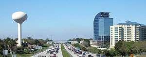
Skyline of Altamonte Springs viewed from I-4, with the unfinished Majesty Building (often called "the Eyesore on I-4") in the background. | |
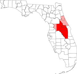
 Location in Seminole County and the state of Florida | |
| Coordinates: 28°39′41″N 81°23′31″W / 28.66139°N 81.39194°WCoordinates: 28°39′41″N 81°23′31″W / 28.66139°N 81.39194°W | |
| Country |
|
| State |
|
| County | Seminole |
| Incorporated | 1920 |
| Government | |
| • Mayor | Pat Bates |
| • City manager | Franklin W. Martz, II |
| Area | |
| • Total | 9.5 sq mi (24.4 km2) |
| • Land | 8.9 sq mi (23 km2) |
| • Water | 0.6 sq mi (1.4 km2) |
| Elevation | 85 ft (26 m) |
| Population (2012) | |
| • Total | 41,920 |
| • Density | 4,604/sq mi (1,778/km2) |
| Time zone | Eastern (EST) (UTC-5) |
| • Summer (DST) | EDT (UTC-4) |
| ZIP code(s) | 32701, 32707, 32714, 32730, 32751 |
| Area code(s) | 407 |
| FIPS code | 12-00950 |
| GNIS feature ID | 0277821[1] |
| Website | http://www.altamonte.org/ |

Altamonte Springs is a suburban city in Seminole County, Florida, which had a population of 41,496 at the 2010 census. Located in Seminole County, the city is in the northern suburbs of the Orlando–Kissimmee–Sanford Metropolitan Statistical Area, which the United States Census Bureau estimated had a population of 2,054,574 in 2008.[2]
Dr. Washington Kilmer of Cincinnati was the first to settle into the area around 1870, and he named the area Altamont (minus the "e" from the present spelling). In 1882, the Altamonte Land, Hotel and Navigation Company gave the area its present name: Altamonte Springs. The company developed the core community along Altamonte Avenue (today's SR 436) between Maitland and Longwood Avenues (today's Ronald Reagan Boulevard). On November 11, 1920, the residents of Altamonte Springs voted 38 to 7 in favor or incorporation.[3] The name Altamonte is Spanish language word meaning "high hill".[4]
Geography
Altamonte Springs is located at 28°39′41″N 81°23′31″W / 28.661463°N 81.392016°W (28.661463, -81.392016).[5]
According to the United States Census Bureau, the city has a total area of 9.4 mi2 (24.5 km2). 8.9 mi2 (23.1 km2) of it is land and 0.6 mi2 (1.5 km2) of it (5.93%) is water.
Government
Altamonte Springs has a City Manager, City Commissioner form of government, consisting of four commission districts and the Mayor serving City-wide.
Demographics
| Historical population | |||
|---|---|---|---|
| Census | Pop. | %± | |
| 1920 | 441 | — | |
| 1930 | 281 | −36.3% | |
| 1940 | 551 | 96.1% | |
| 1950 | 858 | 55.7% | |
| 1960 | 1,212 | 41.3% | |
| 1970 | 4,391 | 262.3% | |
| 1980 | 22,028 | 401.7% | |
| 1990 | 34,879 | 58.3% | |
| 2000 | 41,200 | 18.1% | |
| 2010 | 41,496 | 0.7% | |
| Est. 2015 | 43,159 | [6] | 4.0% |
| U.S. Decennial Census[7] 2012 Estimate[8] | |||
As of the census of 2000, there were 41,200 people, 18,821 households, and 10,012 families residing in the city. The population density was 4,631.1 inhabitants per square mile (1,787.3/km2). There were 19,992 housing units at an average density of 2,247.2 per square mile (867.3/km2). The racial makeup of the city was 79.23% White, 9.72% African American, 0.33% Native American, 2.94% Asian, 0.04% Pacific Islander, 4.79% from other races, and 2.94% from two or more races. Hispanic or Latino of any race were 15.93% of the population.
There were 18,821 households out of which 24.8% had children under the age of 18 living with them, 37.1% were married couples living together, 12.0% had a female householder with no husband present, and 46.8% were non-families. 36.1% of all households were made up of individuals and 6.7% had someone living alone who was 65 years of age or older. The average household size was 2.17 and the average family size was 2.86.
In the city the population was spread out with 20.4% under the age of 18, 10.8% from 18 to 24, 37.1% from 25 to 44, 21.0% from 45 to 64, and 10.7% who are 65 years of age or older. The median age is 34 years. For every 100 females there were 92.6 males. For every 100 females age 18 and over, there were 89.6 males.
The median income for a household in the city was $41,578, and the median income for a family was $49,082. Males had a median income of $34,413 versus $28,897 for females. The per capita income for the city was $23,216. About 5.6% of families and 7.4% of the population were below the poverty line, including 9.5% of those under age 18 and 6.4% of those age 65 or over.
Education
The city of Altamonte Springs' public schools are a part of Seminole County Public Schools. Altamonte Springs is served by 4 public elementary schools (K–5); 1 public middle school (6–8); and 1 public high school (9–12). The city of Altamonte Springs is also home to a branch of Seminole State College of Florida. Additionally, Altamonte Springs boasts 10 percent more college graduates per capita than the Florida average, and is just a few miles away from the University of Central Florida and Rollins College.
Elementary
Middle
Milwee Middle
High
Lyman High School
Private
- Forest Lake Academy
- Forest Lake Education Center
- Altamonte Christian School
- Saint Mary Magdalen School
- Pace Brantley Hall School
- Annunciation Catholic Academy
Colleges
Library
- Altamonte Springs City Library
Cranes Roost Park and Uptown Altamonte
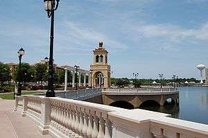
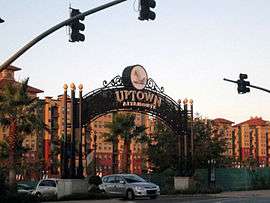
Cranes Roost Park, Cranes Roost Lake, and the general area on State Road 436 east of Interstate 4 is known as the central area of the city. This is the area that borders Interstate 4 which is the main interstate highway for Central Florida connecting Daytona Beach, Orlando, and Tampa. An outdoor town center was recently opened named 'Uptown Altamonte' which marks the central business district of the city. Cranes Roost at Uptown Altamonte features a water fountain choreographed to classical, swing and contemporary music.
This city center incorporates large-scale apartment buildings and planned high rise condominiums. The construction also includes mixed use shops and retailers. The park area includes a square for weddings, festivals, and city holidays. The spot has become popular with Altamonte Springs residents, and attracts residents from nearby Longwood, Casselberry, and Maitland. Future plans include two high rise residential structures (in excess of 10 stories) and a series of parking structures to facilitate visitors.
The area includes the Altamonte Mall, a 4-anchor indoor shopping mall, which includes an 18-screen AMC Theatre. Many restaurants are located near the mall such as several Darden Restaurants, Denny's, and Jason's Deli.
Special events
During recent years, Altamonte Springs has been a host city to several local special events in the Orlando area, including Red, Hot, & Boom, a major annual firework festival that takes place every July 3 in celebration of Independence Day. The Red, Hot, & Boom event draws over 100,000 local residents and visitors annually from the entire Central Florida area, includes appearances musical performances by nationally and internationally known entertainers, and is Central Florida's largest Independence Day Celebration.
Parks and recreation
Parks and events
- Hermits Trail & Turnbull Ave
- Earth Day Event
- Bird Watchers Wanted
- Jr. Rangers Program
- Sunshine Park
- Cranes Roost
- Lake Lotus Nature Park
- Lake Orienta Public Boat Ramp
- Red, Hot, and Boom (Fourth of July Event)
- A Petrified Forest (Halloween Event)
Recreation
- Eastmonte
- Westmonte
- Lake Brantley Sports Complex
- Merrill Park
Winwood Park
Transportation
Airports
Altamonte Springs is served primarily by Orlando International Airport, which is located 30 minutes south. Orlando Sanford International Airport, located 25 minutes north, also serves the area. Orlando Executive Airport, located 20 minutes south, is used for charter flights and general aviation.
Bus service
Altamonte Springs is served by Lynx, offering local transit service which covers the six-county area (Osceola-Orange-Seminole-Lake-Volusia-Polk).
Rail
Altamonte Springs is served by SunRail, the Central Florida Commuter Rail system. The station opened on May 1, 2014.
References
- ↑ "US Board on Geographic Names". United States Geological Survey. 2007-10-25. Retrieved 2008-01-31.
- ↑ http://quickfacts.census.gov/qfd/states/12/1200950.html
- ↑ https://books.google.com/books?id=Y47lsYuu_XYC&pg=PA21&lpg=PA21&dq=Altamonte+Land,+Hotel+and+Navigation+Company+1887&source=bl&ots=86WAy0q444&sig=REl_XI6uI-1i_b1S3UezlVWvIds&hl=en&sa=X&ei=a8n0UuFqkM-RB92agCg&ved=0CCsQ6AEwAQ#v=onepage&q=Altamonte%20Land%2C%20Hotel%20and%20Navigation%20Company%201887&f=false
- ↑ http://dhr.dos.state.fl.us/facts/reports/names/index.cfm#A
- ↑ "US Gazetteer files: 2010, 2000, and 1990". United States Census Bureau. 2011-02-12. Retrieved 2011-04-23.
- ↑ "Annual Estimates of the Resident Population for Incorporated Places: April 1, 2010 to July 1, 2015". Retrieved July 2, 2016.
- ↑ United States Census Bureau. "Census of Population and Housing". Archived from the original on May 11, 2015. Retrieved November 18, 2013.
- ↑ "Annual Estimates of the Resident Population: April 1, 2010 to July 1, 2012". Retrieved November 18, 2013.
External links
| Wikivoyage has a travel guide for Altamonte Springs. |
| Wikimedia Commons has media related to Altamonte Springs, Florida. |
- Official website
- Seminole County Convention and Visitors Bureau
- Altamonte Springs Collection on the RICHES Mosaic Interface Map
- Altamonte Springs City Library
Municipalities and communities of Seminole County, Florida, United States | ||
|---|---|---|
| Cities | 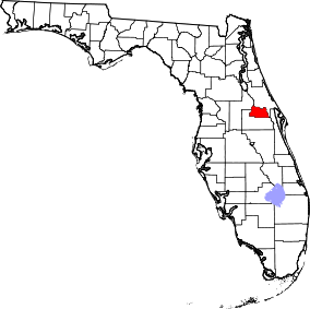 | |
| CDPs |
| |
| Unincorporated communities | ||
| Footnotes | ‡This populated place also has portions in an adjacent county or counties | |
| Attractions |
|  |
|---|---|---|
| Colleges and universities | ||
| Media |
| |
| Airports | ||
| Counties | ||
| Cities and towns 25k+ | ||
| Cities and towns 10k–25k | ||
‡ This populated place is included in the Orlando–Deltona–Daytona Beach, FL Combined Statistical Area. See also: | ||
