Baker County, Florida
| Baker County, Florida | ||
|---|---|---|
.jpg) Baker County Courthouse in Macclenny | ||
| ||
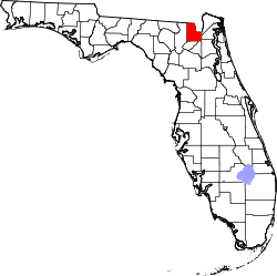 Location in the U.S. state of Florida | ||
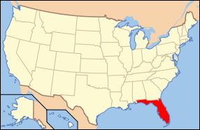 Florida's location in the U.S. | ||
| Founded | February 8, 1861 | |
| Named for | James McNair Baker | |
| Seat | Macclenny | |
| Largest city | Macclenny | |
| Area | ||
| • Total | 589 sq mi (1,526 km2) | |
| • Land | 585 sq mi (1,515 km2) | |
| • Water | 3.7 sq mi (10 km2), 0.6% | |
| Population (est.) | ||
| • (2015) | 27,420 | |
| • Density | 46/sq mi (18/km²) | |
| Congressional district | 4th | |
| Time zone | Eastern: UTC-5/-4 | |
| Website |
www | |

Baker County is a county located in the U.S. state of Florida. As of the 2010 census, the population was 27,115.[1] Its county seat is Macclenny, Florida.[2] The county was founded in 1861 and is named for James McNair Baker, a judge and Confederate Senator.
Baker County is included in the Jacksonville, FL Metropolitan Statistical Area.
In 1864 the Battle of Olustee, which was the only major American Civil War battle in Florida, was fought near Lake City, Florida in Baker County.
History
Baker County was founded in 1861. It was named for James McNair Baker, a judge and Confederate senator.[3] In 1864 the Battle of Olustee, which was the only major American Civil War battle in Florida, was fought near Lake City, Florida in Baker County.[4]
Geography
According to the U.S. Census Bureau, the county has a total area of 589 square miles (1,530 km2), of which 585 square miles (1,520 km2) is land and 3.7 square miles (9.6 km2) (0.6%) is water.[5] The extreme northern part of the county lies within the Okefenokee Swamp and its federally protected areas. Baker County is just one of the many counties that is home to the St. Mary's River. The St. Marys River is a remote blackwater stream, located in southeastern Georgia and northeastern Florida, forming the easternmost border between the two states.[6][7]
Adjacent counties
- Charlton County, Georgia - north
- Ware County, Georgia - north
- Nassau County, Florida - northeast
- Duval County, Florida - east
- Clay County, Florida - southeast
- Union County, Florida - south
- Bradford County, Florida - south
- Columbia County, Florida - west
- Clinch County, Georgia - northwest
National protected areas
- Okefenokee National Wildlife Refuge (part)
- Osceola National Forest (part)
Major highways
Demographics
| Historical population | |||
|---|---|---|---|
| Census | Pop. | %± | |
| 1870 | 1,325 | — | |
| 1880 | 2,303 | 73.8% | |
| 1890 | 3,333 | 44.7% | |
| 1900 | 4,516 | 35.5% | |
| 1910 | 4,805 | 6.4% | |
| 1920 | 5,622 | 17.0% | |
| 1930 | 6,273 | 11.6% | |
| 1940 | 6,510 | 3.8% | |
| 1950 | 6,313 | −3.0% | |
| 1960 | 7,363 | 16.6% | |
| 1970 | 9,242 | 25.5% | |
| 1980 | 15,289 | 65.4% | |
| 1990 | 18,486 | 20.9% | |
| 2000 | 22,259 | 20.4% | |
| 2010 | 27,115 | 21.8% | |
| Est. 2015 | 27,420 | [8] | 1.1% |
| U.S. Decennial Census[9] 1790-1960[10] 1900-1990[11] 1990-2000[12] 2010-2015[1] | |||
As of the census[13] of 2000, there were 22,259 people, 7,043 households, and 5,599 families residing in the county. The population density was 38 people per square mile (15/km²). There were 7,592 housing units at an average density of 13 per square mile (5/km²). The racial makeup of the county was 84.04% White, 13.92% Black or African American, 0.38% Native American, 0.40% Asian, 0.03% Pacific Islander, 0.25% from other races, and 0.98% from two or more races. 1.88% of the population were Hispanic or Latino of any race. 34.5% were of American, 9.9% Irish, 8.6% English and 6.6% German ancestry according to Census 2000. Those claiming "American" ancestry are of predominantly English ancestry but most people in Baker County who are of English stock have a tendency to identify simply as Americans.[14][15][16][17] 97.2% spoke English and 2.5% Spanish as their first language.
There were 7,043 households out of which 41.20% had children under the age of 18 living with them, 61.70% were married couples living together, 13.10% had a female householder with no husband present, and 20.50% were non-families. 17.10% of all households were made up of individuals and 6.90% had someone living alone who was 65 years of age or older. The average household size was 2.86 and the average family size was 3.20.
In the county the population was spread out with 27.50% under the age of 18, 9.90% from 18 to 24, 30.70% from 25 to 44, 22.70% from 45 to 64, and 9.20% who were 65 years of age or older. The median age was 34 years. For every 100 females there were 110.60 males. For every 100 females age 18 and over, there were 112.40 males.
The median income for a household in the county was $40,035, and the median income for a family was $43,503. Males had a median income of $30,240 versus $21,279 for females. The per capita income for the county was $15,164. About 11.40% of families and 14.70% of the population were below the poverty line, including 22.20% of those under age 18 and 8.60% of those age 65 or over.
Politics
Voter registration
According to the Secretary of State's office, Democrats hold a narrow plurality among registered voters in Baker County.
| Baker County Voter Registration & Party Enrollment as of September 30, 2015[18] | |||||
|---|---|---|---|---|---|
| Political Party | Total Voters | Percentage | |||
| Democratic | 6,416 | 45.63% | |||
| Republican | 6,170 | 43.88% | |||
| Independent | 1,267 | 9.01% | |||
| Third Parties | 207 | 1.47% | |||
| Total | 14,060 | 100% | |||
Statewide elections
| Year | Republican | Democratic | Third Parties |
|---|---|---|---|
| 2012 | 78.80% 8,975 | 20.29% 2,311 | 0.91% 104 |
| 2008 | 78.22% 8,672 | 20.99% 2,327 | 0.79% 88 |
| 2004 | 77.73% 7,738 | 21.90% 2,180 | 0.37% 37 |
| 2000 | 68.80% 5,611 | 29.33% 2,392 | 1.87% 152 |
| 1996 | 55.53% 3,684 | 34.26% 2,273 | 10.21% 677 |
| 1992 | 50.60% 3,417 | 29.23% 1,974 | 20.17% 1,362 |
| Year | Republican | Democratic | Third Parties |
|---|---|---|---|
| 2014 | 70.54% 5,956 | 24.87% 2,100 | 4.59% 388 |
| 2010 | 62.34% 4,940 | 34.46% 2,731 | 3.20% 253 |
| 2006 | 69.39% 4,335 | 27.82% 1,738 | 2.79% 174 |
| 2002 | 69.22% 4,515 | 30.06% 1,961 | 0.72% 47 |
| 1998 | 71.14% 3,268 | 28.86% 1,326 | 0.00% 0 |
| 1994 | 68.52% 3,600 | 31.48% 1,654 | 0.00% 0 |
Library
The main library serving Baker County is the Emily Taber Public Library. The building used to be the Old Baker County Courthouse, built in 1908. The current library director is April Teel.[19]
Communities
City
Town
Unincorporated communities
See also
References
- 1 2 "State & County QuickFacts". United States Census Bureau. Retrieved February 11, 2014.
- ↑ "Find a County". National Association of Counties. Archived from the original on 2011-05-31. Retrieved 2011-06-07.
- ↑ Publications of the Florida Historical Society. Florida Historical Society. 1908. p. 30.
- ↑ National Park Service "American Battlefield Protection Program Battle Summary" Check
|url=value (help). National Park Service. Retrieved 2007-12-31.|section=ignored (help) - ↑ "US Gazetteer files: 2010, 2000, and 1990". United States Census Bureau. 2011-02-12. Retrieved 2011-04-23.
- ↑ "Florida's Water". http://floridaswater.com/stmarysriverguide/. Retrieved 2015-03-05. External link in
|website=(help) - ↑ "Baker County Geography". http://stmaryriverbaker.weebly.com. Thomas. Retrieved 5 March 2015. External link in
|website=(help) - ↑ "County Totals Dataset: Population, Population Change and Estimated Components of Population Change: April 1, 2010 to July 1, 2015". Retrieved July 2, 2016.
- ↑ "U.S. Decennial Census". United States Census Bureau. Archived from the original on May 11, 2015. Retrieved June 12, 2014.
- ↑ "Historical Census Browser". University of Virginia Library. Retrieved June 12, 2014.
- ↑ "Population of Counties by Decennial Census: 1900 to 1990". United States Census Bureau. Retrieved June 12, 2014.
- ↑ "Census 2000 PHC-T-4. Ranking Tables for Counties: 1990 and 2000" (PDF). United States Census Bureau. Retrieved June 12, 2014.
- ↑ "American FactFinder". United States Census Bureau. Archived from the original on 2013-09-11. Retrieved 2011-05-14.
- ↑ Sharing the Dream: White Males in a Multicultural America By Dominic J. Pulera.
- ↑ Reynolds Farley, 'The New Census Question about Ancestry: What Did It Tell Us?', Demography, Vol. 28, No. 3 (August 1991), pp. 414, 421.
- ↑ Stanley Lieberson and Lawrence Santi, 'The Use of Nativity Data to Estimate Ethnic Characteristics and Patterns', Social Science Research, Vol. 14, No. 1 (1985), pp. 44-6.
- ↑ Stanley Lieberson and Mary C. Waters, 'Ethnic Groups in Flux: The Changing Ethnic Responses of American Whites', Annals of the American Academy of Political and Social Science, Vol. 487, No. 79 (September 1986), pp. 82-86.
- ↑ http://dos.myflorida.com/elections/data-statistics/voter-registration-statistics/voter-registration-monthly-reports/voter-registration-current-by-county/
- ↑ "New River Public Library Cooperative".
External links
| Wikivoyage has a travel guide for Baker County (Florida). |
| Wikimedia Commons has media related to Baker County, Florida. |
Government links/Constitutional offices
- Baker County Board of County Commissioners
- Baker County Supervisor of Elections
- Baker County Property Appraiser
- Baker County Sheriff's Office
- Baker County Tax Collector
Special districts
Judicial branch
- Baker County Clerk of Courts
- Office of the State Attorney, 8th Judicial Circuit of Florida serving Alachua, Baker, Bradford, Gilchrist, Levy and Union Counties
- Circuit and County Court for the 8th Judicial Circuit of Florida
Community Web Pages
- BakerCountyToday.org - Baker County, Florida: Today and Yesterday
- Baker County Community Home Page - BakerCountyFL.com - Owned and Managed from Baker County
Federal
Museum and Library Resources
- The Baker County Press, the local newspaper for Baker County, Florida fully and openly available in the Florida Digital Newspaper Library
 |
Clinch County, Georgia | Charlton County, Georgia and Ware County, Georgia | Nassau County | |
| Columbia County | |
Duval County | ||
| ||||
| | ||||
| Bradford County and Union County | Clay County |
Municipalities and communities of Baker County, Florida, United States | ||
|---|---|---|
| City | | |
| Town | ||
| Unincorporated communities | ||
| Central city | 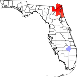 | |
|---|---|---|
| Municipalities over 10,000 population (in 2000) | ||
| Municipalities 1,000-10,000 population (in 2000) |
| |
| Counties | ||

Coordinates: 30°19′N 82°16′W / 30.32°N 82.27°W