Union Park, Florida
| Union Park, Florida | |
|---|---|
| Census-designated place | |
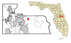 Location in Orange County and the state of Florida | |
| Coordinates: 28°33′56″N 81°14′14″W / 28.56556°N 81.23722°WCoordinates: 28°33′56″N 81°14′14″W / 28.56556°N 81.23722°W | |
| Country |
|
| State |
|
| County | Orange |
| Area | |
| • Total | 3 sq mi (7.8 km2) |
| • Land | 3 sq mi (7.7 km2) |
| • Water | 0 sq mi (0.1 km2) |
| Elevation | 82 ft (25 m) |
| Population (2010) | |
| • Total | 9,765 |
| • Density | 3,300/sq mi (1,300/km2) |
| Time zone | Eastern (EST) (UTC-5) |
| • Summer (DST) | EDT (UTC-4) |
| ZIP codes | 32817, 32825 |
| Area code(s) | 407 |
| FIPS code | 12-73075[1] |
| GNIS feature ID | 0292669[2] |
Union Park is a census-designated place (CDP) in Orange County, Florida, United States. The population was 9,765 at the 2010 census.[3] It is part of the Orlando–Kissimmee Metropolitan Statistical Area. The ZIP codes for Union Park are 32817 and 32825. The community is southwest of the University of Central Florida.
Geography
Union Park is located at 28°33′56″N 81°14′14″W / 28.56556°N 81.23722°W (28.565461, -81.237144).[4]
According to the United States Census Bureau, the CDP has a total area of 7.8 km² (3.0 mi²), of which 7.7 km² (3.0 mi²) is land and 0.1 km² (0.04 mi²) (0.99%) is water. The elevation is 82 feet (25 m) above sea level.
The boundaries of Union Park are North Dean Road to the west, the Econlockhatchee River to the west and north, J Blanchard Trail to the north, Rouse Road to the east, and Bloomfield Drive to the south.[5]
Schooling
Union Park has five schools: one elementary, one middle, one charter and two high schools.
- Union Park Elementary School (OCPS)
- Union Park Middle School (OCPS)
- Colonial High School (OCPS)
- University High School (OCPS)
- Renaissance Charter School (Independent)
Demographics
As of the census[1] of 2000, there were 10,191 people, 3,644 households, and 2,507 families residing in the CDP. The population density was 1,316.0/km² (3,411.5/mi²). There were 3,791 housing units at an average density of 489.5/km² (1,269.1/mi²). The racial makeup of the CDP was 78.16% White, 4.94% African American, 0.32% Native American, 3.45% Asian, 0.06% Pacific Islander, 9.43% from other races, and 3.64% from two or more races. Hispanic or Latino of any race were 26.07% of the population. The ancestral population are German (12.3%), Irish (10.5%), English (8.1%), United States (6.8%), Italian (6.6%) and Polish (3.2%). 10.2% of the community's population is foreign born (6.4% Latin America, 1.8% Asia).
There were 3,644 households out of which 33.3% had children under the age of 18 living with them, 50.6% were married couples living together, 13.2% had a female householder with no husband present, and 31.2% were non-families. 17.3% of all households were made up of individuals and 3.6% had someone living alone who was 65 years of age or older. The average household size was 2.79 and the average family size was 3.19.
In the CDP the population was spread out with 24.9% under the age of 18, 14.8% from 18 to 24, 32.6% from 25 to 44, 19.0% from 45 to 64, and 8.7% who were 65 years of age or older. The median age was 31 years. For every 100 females there were 100.5 males. For every 100 females age 18 and over, there were 97.9 males.
The median income for a household in the CDP was $44,174, and the median income for a family was $45,191. Males had a median income of $31,982 versus $23,384 for females. The per capita income for the CDP was $19,087. About 7.9% of families and 11.3% of the population were below the poverty line, including 13.9% of those under age 18 and 9.5% of those age 65 or over.
Population history
| Historical population | |||
|---|---|---|---|
| Census | Pop. | %± | |
| 1970 | 2,827 | — | |
| 1980 | 19,175 | 578.3% | |
| 1990 | 6,890 | −64.1% | |
| 2000 | 10,191 | 47.9% | |
| 2010 | 9,765 | −4.2% | |
| Source:[3][6] 1980 census boundaries included the separate community of University Park; the boundaries were scaled back significantly in the 1990 census. | |||
Neighboring communities
The nearest communities are Azalea Park (4 miles southwest), Goldenrod (5 miles northwest), Oviedo (8 miles north), Winter Park (8.5 miles northwest), Conway (8 miles southwest), and Bithlo (8 miles east). Downtown Orlando is 9 miles to the west.
References
- 1 2 "American FactFinder". United States Census Bureau. Archived from the original on September 11, 2013. Retrieved 2008-01-31.
- ↑ "US Board on Geographic Names". United States Geological Survey. 2007-10-25. Retrieved 2008-01-31.
- 1 2 "Profile of General Population and Housing Characteristics: 2010 Demographic Profile Data (DP-1): Union Park CDP, Florida". U.S. Census Bureau, American Factfinder. Archived from the original on September 11, 2013. Retrieved September 25, 2012.
- ↑ "US Gazetteer files: 2010, 2000, and 1990". United States Census Bureau. 2011-02-12. Retrieved 2011-04-23.
- ↑ U.S. Census Bureau block maps, Orange County, Florida; January 2011
- ↑ "CENSUS OF POPULATION AND HOUSING (1790-2000)". U.S. Census Bureau. Retrieved 2010-07-17.
Municipalities and communities of Orange County, Florida, United States | ||
|---|---|---|
| Cities | 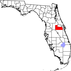 | |
| Towns | ||
| CDPs |
| |
| Unincorporated communities | ||
| Footnotes | ‡This populated place also has portions in an adjacent county or counties | |