West Long Branch, New Jersey
| West Long Branch, New Jersey | |
|---|---|
| Borough | |
| Borough of West Long Branch | |
|
| |
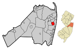 Map of West Long Branch in Monmouth County. Inset: Location of Monmouth County highlighted in the State of New Jersey. | |
 Census Bureau map of West Long Branch, New Jersey | |
| Coordinates: 40°17′16″N 74°01′12″W / 40.287904°N 74.020019°WCoordinates: 40°17′16″N 74°01′12″W / 40.287904°N 74.020019°W[1][2] | |
| Country |
|
| State |
|
| County | Monmouth |
| Incorporated | May 5, 1908 |
| Government[3] | |
| • Type | Borough |
| • Body | Borough Council |
| • Mayor | Janet W. Tucci (R, term ends December 31, 2018)[4][5] |
| • Administrator | John J. Kennedy[6] |
| • Clerk | Lori Cole[7] |
| Area[1] | |
| • Total | 2.894 sq mi (7.496 km2) |
| • Land | 2.858 sq mi (7.403 km2) |
| • Water | 0.036 sq mi (0.093 km2) 1.24% |
| Area rank |
341st of 566 in state 23rd of 53 in county[1] |
| Elevation[8] | 26 ft (8 m) |
| Population (2010 Census)[9][10][11] | |
| • Total | 8,097 |
| • Estimate (2015)[12] | 7,994 |
| • Rank |
284th of 566 in state 22nd of 53 in county[13] |
| • Density | 2,832.9/sq mi (1,093.8/km2) |
| • Density rank |
223rd of 566 in state 26th of 53 in county[13] |
| Time zone | Eastern (EST) (UTC-5) |
| • Summer (DST) | Eastern (EDT) (UTC-4) |
| ZIP code | 07764[14][15] |
| Area code(s) | 732 and 908 (cell)[16] |
| FIPS code | 3402579310[1][17][18] |
| GNIS feature ID | 0885437[1][19] |
| Website |
www |

West Long Branch is a borough in Monmouth County, New Jersey, United States. As of the 2010 United States Census, the borough's population was 8,097,[9][10][11] reflecting a decline of 161 (-1.9%) from the 8,258 counted in the 2000 Census, which had in turn increased by 568 (+7.4%) from the 7,690 counted in the 1990 Census.[20] It is the home of Monmouth University.
History
Prior to being called West Long Branch, the area had been called Mechanicsville from the 18th century through the Civil War, and then Branchburg in the 1870s. The name West Long Branch appears in the 1889 Wolverton Atlas of Monmouth County, and seems to have derived its name from its proximity to a section of the Shrewsbury River.[21]
In 1908, the residents of what was the West Long Branch section of Eatontown thought that they were not getting a fair return on their taxes. A request was made that the West Long Branch section be separated from Eatontown. The Township of Eatontown strongly resisted as there were several large estates in the West Long Branch section that were a source of considerable taxes. An act of the New Jersey Legislature was passed on April 7, 1908, and the Monmouth County Board of Chosen Freeholders authorized an election. On May 5, 1908, the referendum was held in West Long Branch, with voters approving the separation.[22][23] The borough takes its name from Long Branch, which in turn takes its name from the "long branch" or south branch of the Shrewsbury River.[24][25][26][27]
Geography

According to the United States Census Bureau, West Long Branch had a total area of 2.894 square miles (7.496 km2), including 2.858 square miles (7.403 km2) of land and 0.036 square miles (0.093 km2) of water (1.24%).[1][2]
Unincorporated communities, localities and place names located partially or completely within the borough include Norwood Park.[28]
The borough borders the Monmouth County municipalities of Eatontown, Long Branch, Ocean Township and Oceanport.[29]
Demographics
| Historical population | |||
|---|---|---|---|
| Census | Pop. | %± | |
| 1910 | 879 | — | |
| 1920 | 1,686 | 91.8% | |
| 1930 | 1,686 | 0.0% | |
| 1940 | 2,030 | 20.4% | |
| 1950 | 2,739 | 34.9% | |
| 1960 | 5,337 | 94.9% | |
| 1970 | 6,845 | 28.3% | |
| 1980 | 7,380 | 7.8% | |
| 1990 | 7,690 | 4.2% | |
| 2000 | 8,258 | 7.4% | |
| 2010 | 8,097 | −1.9% | |
| Est. 2015 | 7,994 | [12][30] | −1.3% |
| Population sources: 1910-1920[31] 1910[32] 1910-1930[33] 1930-1990[34] 2000[35][36] 2010[9][10][11] | |||
Census 2010
The 2010 United States Census counted 8,097 people, 2,384 households, and 1,757 families residing in the borough. The population density was 2,832.9 per square mile (1,093.8/km2). The borough contained 2,528 housing units at an average density of 884.5 per square mile (341.5/km2). The racial makeup of the borough was 94.45% (7,648) White, 2.21% (179) Black or African American, 0.06% (5) Native American, 1.19% (96) Asian, 0.01% (1) Pacific Islander, 0.95% (77) from other races, and 1.12% (91) from two or more races. Hispanics or Latinos of any race were 5.03% (407) of the population.[9]
Out of a total of 2,384 households, 32.3% had children under the age of 18 living with them, 60.0% were married couples living together, 9.8% had a female householder with no husband present, and 26.3% were non-families. 21.7% of all households were made up of individuals, and 12.7% had someone living alone who was 65 years of age or older. The average household size was 2.77 and the average family size was 3.23.[9]
In the borough, 19.6% of the population were under the age of 18, 25.4% from 18 to 24, 16.7% from 25 to 44, 24.7% from 45 to 64, and 13.6% who were 65 years of age or older. The median age was 32.4 years. For every 100 females the census counted 91.2 males, but for 100 females at least 18 years old, it was 88.1 males.[9]
The Census Bureau's 2006-2010 American Community Survey showed that (in 2010 inflation-adjusted dollars) median household income was $96,369 (with a margin of error of +/- $15,449) and the median family income was $114,250 (+/- $13,662). Males had a median income of $75,634 (+/- $8,441) versus $49,483 (+/- $5,714) for females. The per capita income for the borough was $32,822 (+/- $3,260). About 5.0% of families and 8.2% of the population were below the poverty line, including 11.0% of those under age 18 and 6.3% of those age 65 or over.[37]
Census 2000
As of the 2000 United States Census[17] there were 8,258 people, 2,448 households, and 1,860 families residing in the borough. The population density was 2,859.9 people per square mile (1,103.3/km2). There were 2,535 housing units at an average density of 877.9 per square mile (338.7/km2). The racial makeup of the borough was 94.22% White, 2.23% African American, 0.07% Native American, 1.21% Asian, 0.04% Pacific Islander, 0.50% from other races, and 1.73% from two or more races. Hispanic or Latino of any race were 2.92% of the population.[35][36]
There were 2,448 households out of which 35.5% had children under the age of 18 living with them, 64.9% were married couples living together, 8.6% had a female householder with no husband present, and 24.0% were non-families. 21.3% of all households were made up of individuals and 13.3% had someone living alone who was 65 years of age or older. The average household size was 2.77 and the average family size was 3.25.[35][36]
In the borough the population was spread out with 21.8% under the age of 18, 22.1% from 18 to 24, 21.1% from 25 to 44, 20.4% from 45 to 64, and 14.6% who were 65 years of age or older. The median age was 34 years. For every 100 females there were 87.6 males. For every 100 females age 18 and over, there were 84.7 males.[35][36]
The median income for a household in the borough was $71,852, and the median income for a family was $80,127. Males had a median income of $59,638 versus $34,000 for females. The per capita income for the borough was $27,651. About 3.1% of families and 4.5% of the population were below the poverty line, including 7.0% of those under age 18 and 3.2% of those age 65 or over.[35][36]
Government
Local government
West Long Branch is governed under the Borough form of New Jersey municipal government. The governing body consists of a Mayor and a Borough Council comprising six council members, with all positions elected at-large on a partisan basis as part of the November general election. A Mayor is elected directly by the voters to a four-year term of office. The Borough Council consists of six members elected to serve three-year terms on a staggered basis, with two seats coming up for election each year in a three-year cycle.[3] The Borough form of government used by West Long Branch, the most common system used in the state, is a "weak mayor / strong council" government in which council members act as the legislative body with the mayor presiding at meetings and voting only in the event of a tie. The mayor can veto ordinances subject to an override by a two-thirds majority vote of the council. The mayor makes committee and liaison assignments for council members, and most appointments are made by the mayor with the advice and consent of the council.[38][39]
As of 2016, the Mayor of the Borough of West Long Branch is Republican Janet W. Tucci, whose term of office ends December 31, 2018.[4] Members of the West Long Branch Borough Council are John M. Aria, Jr. (R, 2016), Susan Juliano (D, 2018), Fred Migliaccio (R, 2017), Christopher M. Neyhart (R, 2017), John M. Penta, Jr. (D, 2018) and Jose E. Villa (R, 2016).[40][41][42][43][44][45]
Police department
The West Long Branch Police Department is responsible for Law and Traffic Enforcement within the borders of the Borough of West Long Branch. Its current Chief is Paul Habermann.[46]
The Department has two divisions, Operations and Investigations. The Operations Division consists of Patrol, Traffic, Dispatch, Firearms, Records and Special Services. The Investigations Division is responsible for all criminal investigations.
Federal, state and county representation
West Long Branch is located in the 6th Congressional District[47] and is part of New Jersey's 11th state legislative district.[10][48][49]
New Jersey's Sixth Congressional District is represented by Frank Pallone (D, Long Branch).[50] New Jersey is represented in the United States Senate by Cory Booker (D, Newark, term ends 2021)[51] and Bob Menendez (D, Paramus, 2019).[52][53]
For the 2016–2017 session (Senate, General Assembly), the 11th Legislative District of the New Jersey Legislature is represented in the State Senate by Jennifer Beck (R, Red Bank) and in the General Assembly by Joann Downey (D, Freehold Township) and Eric Houghtaling (D, Neptune Township).[54] The Governor of New Jersey is Chris Christie (R, Mendham Township).[55] The Lieutenant Governor of New Jersey is Kim Guadagno (R, Monmouth Beach).[56]
Monmouth County is governed by a Board of Chosen Freeholders consisting of five members who are elected at-large to serve three year terms of office on a staggered basis, with either one or two seats up for election each year as part of the November general election. At an annual reorganization meeting held in the beginning of January, the board selects one of its members to serve as Director and another as Deputy Director.[57] As of 2014, Monmouth County's Freeholders are Freeholder Director Lillian G. Burry (R, Colts Neck Township; term ends December 31, 2014),[58] Freeholder Deputy Director Gary J. Rich, Sr. (R, Spring Lake; 2014),[59] Thomas A. Arnone (R, Neptune City; 2016),[60] John P. Curley (R, Middletown Township; 2015)[61] and Serena DiMaso (R, Holmdel Township; 2016).[62][63] Constitutional officers elected on a countywide basis are County Clerk M. Claire French (Wall Township),[64] Sheriff Shaun Golden (Farmingdale)[65] and Surrogate Rosemarie D. Peters (Middletown Township).[66]
Politics
As of March 23, 2011, there were a total of 4,862 registered voters in West Long Branch, of which 1,189 (24.5%) were registered as Democrats, 1,049 (21.6%) were registered as Republicans and 2,622 (53.9%) were registered as Unaffiliated. There were 2 voters registered to other parties.[67]
In the 2012 presidential election, Republican Mitt Romney received 57.6% of the vote (2,029 cast), ahead of Democrat Barack Obama with 41.5% (1,461 votes), and other candidates with 0.9% (31 votes), among the 3,548 ballots cast by the borough's 5,079 registered voters (27 ballots were spoiled), for a turnout of 69.9%.[68][69] In the 2008 presidential election, Republican John McCain received 57.4% of the vote (2,208 cast), ahead of Democrat Barack Obama with 39.6% (1,524 votes) and other candidates with 1.2% (47 votes), among the 3,844 ballots cast by the borough's 5,065 registered voters, for a turnout of 75.9%.[70] In the 2004 presidential election, Republican George W. Bush received 57.4% of the vote (2,202 ballots cast), outpolling Democrat John Kerry with 41.1% (1,574 votes) and other candidates with 0.8% (38 votes), among the 3,833 ballots cast by the borough's 4,926 registered voters, for a turnout percentage of 77.8.[71]
In the 2013 gubernatorial election, Republican Chris Christie received 72.7% of the vote (1,612 cast), ahead of Democrat Barbara Buono with 25.8% (573 votes), and other candidates with 1.4% (32 votes), among the 2,246 ballots cast by the borough's 5,068 registered voters (29 ballots were spoiled), for a turnout of 44.3%.[72][73] In the 2009 gubernatorial election, Republican Chris Christie received 63.1% of the vote (1,732 ballots cast), ahead of Democrat Jon Corzine with 28.9% (794 votes), Independent Chris Daggett with 6.4% (176 votes) and other candidates with 0.7% (18 votes), among the 2,743 ballots cast by the borough's 4,872 registered voters, yielding a 56.3% turnout.[74]
Education

Students in pre-Kindergarten through eighth grade are educated by the West Long Branch Public Schools. As of the 2011-12 school year, the district's two schools had an enrollment of 592 students and 57.0 classroom teachers (on an FTE basis), for a student–teacher ratio of 10.39:1.[75] Schools in the district (with 2011-12 enrollment data from the National Center for Education Statistics[76]) are Betty McElmon Elementary School[77] with 237 students in pre-Kindergarten through third grade and Frank Antonides School[78] with 355 students in fourth through eighth grade.[79][80]
For ninth through twelfth grades, public school students attend Shore Regional High School, a regional high school located in West Long Branch that serves students from the constituent districts of Monmouth Beach, Oceanport, Sea Bright and West Long Branch.[81][82] The high school is part of the Shore Regional High School District. As of the 2013-14 school year, the high school had an enrollment of 642 students and 58.0 classroom teachers (on an FTE basis), for a student–teacher ratio of 11.1:1.[83]
Established in 1933, Monmouth University is a four-year private university on a 155-acre (0.63 km2) campus, with 5,600 students and 232 full-time faculty.[84] The campus is notable for Wilson Hall, a National Historic Landmark that was used in the 1982 film Annie.[85]
Transportation
Roads and highways
As of May 2010, the borough had a total of 36.65 miles (58.98 km) of roadways, of which 27.84 miles (44.80 km) were maintained by the municipality, 5.19 miles (8.35 km) by Monmouth County and 3.62 miles (5.83 km) by the New Jersey Department of Transportation.[86]
Route 36 and Route 71 intersect in the borough.[87][88]
Public transportation
New Jersey Transit provides local bus service on the 831 and 837 routes. The nearest train service is available at the Long Branch station on the North Jersey Coast Line.[89]
Notable people
People who were born in, residents of, or otherwise closely associated with West Long Branch include:
- Holly Black (born 1971), author of the Spiderwick series of books.[90]
- Chester Bowman (1901-1936), sprinter who competed in the 1924 Summer Olympics.[91]
- Bessie Clayton (c. 1875-1948), toe-tap dancer.[92]
- Stephen Donaldson (1946-1996), LGBT rights and prison reform activist.[93]
- Clarkson Sherman Fisher (1921-1997), federal judge who served as a councilmember in West Long Branch and later as Chief Judge of the United States District Court for the District of New Jersey.[94]
- Jon Herington (born 1954), jazz guitarist.[95]
- Elise Primavera (born 1955), author and illustrator of children's books, including The Secret Order of the Gumm Street Girls.[96]
- Arthur Pryor (1870-1942), trombone virtuoso, bandleader, and soloist with the Sousa Band who was a prolific composer of band music, best known for "The Whistler and His Dog".[97]
- T. M. Stevens (born 1951), bassist.[98]
- Jordan Woolley (born 1981), actor.[99]
- Jimmy Zoppi (born 1954), musician and voice actor.[100]
References
- 1 2 3 4 5 6 2010 Census Gazetteer Files: New Jersey County Subdivisions, United States Census Bureau. Accessed May 21, 2015.
- 1 2 US Gazetteer files: 2010, 2000, and 1990, United States Census Bureau. Accessed September 4, 2014.
- 1 2 2012 New Jersey Legislative District Data Book, Rutgers University Edward J. Bloustein School of Planning and Public Policy, March 2013, p. 58.
- 1 2 Mayor Janet W. Tucci, Borough of West Long Branch. Accessed July 19, 2016.
- ↑ 2016 New Jersey Mayors Directory, New Jersey Department of Community Affairs. Accessed June 14, 2016.
- ↑ Borough Administrator, Borough of West Long Branch. Accessed August 4, 2012.
- ↑ Borough Clerk, Borough of West Long Branch. Accessed July 19, 2016.
- ↑ U.S. Geological Survey Geographic Names Information System: Borough of West Long Branch, Geographic Names Information System. Accessed March 14, 2013.
- 1 2 3 4 5 6 DP-1 - Profile of General Population and Housing Characteristics: 2010 for West Long Branch borough, Monmouth County, New Jersey, United States Census Bureau. Accessed August 4, 2012.
- 1 2 3 4 Municipalities Grouped by 2011-2020 Legislative Districts, New Jersey Department of State, p. 6. Accessed January 6, 2013.
- 1 2 3 Profile of General Demographic Characteristics: 2010 for West Long Branch borough, New Jersey Department of Labor and Workforce Development. Accessed August 4, 2012.
- 1 2 PEPANNRES - Annual Estimates of the Resident Population: April 1, 2010 to July 1, 2015 - 2015 Population Estimates for New Jersey municipalities, United States Census Bureau. Accessed May 22, 2016.
- 1 2 GCT-PH1 Population, Housing Units, Area, and Density: 2010 - State -- County Subdivision from the 2010 Census Summary File 1 for New Jersey, United States Census Bureau. Accessed December 13, 2012.
- ↑ Look Up a ZIP Code for West Long Branch, NJ, United States Postal Service. Accessed August 4, 2012.
- ↑ Zip Codes, State of New Jersey. Accessed August 20, 2013.
- ↑ Area Code Lookup - NPA NXX for West Long Branch, NJ, Area-Codes.com. Accessed September 1, 2013.
- 1 2 American FactFinder, United States Census Bureau. Accessed September 4, 2014.
- ↑ A Cure for the Common Codes: New Jersey, Missouri Census Data Center. Accessed August 4, 2012.
- ↑ US Board on Geographic Names, United States Geological Survey. Accessed September 4, 2014.
- ↑ Table 7. Population for the Counties and Municipalities in New Jersey: 1990, 2000 and 2010, New Jersey Department of Labor and Workforce Development, February 2011. Accessed August 4, 2012.
- ↑ History, West Long Branch. Accessed December 13, 2012. "In the past, our community has been known by various names; Hoppersville, from the Hopper family; Mechanicsville, 1851 map; Branchburg, 1873 map, likely due to its proximity to the long branch of the Shrewsbury River."
- ↑ Snyder, John P. The Story of New Jersey's Civil Boundaries: 1606-1968, Bureau of Geology and Topography; Trenton, New Jersey; 1969. p. 187. Accessed April 19, 2012.
- ↑ Honeyman, Abraham Van Doren. Index-analysis of the Statutes of New Jersey, 1896-1909: Together with References to All Acts, and Parts of Acts, in the 'General Statutes' and Pamphlet Laws Expressly Repealed: and the Statutory Crimes of New Jersey During the Same Period, p. 313. New Jersey Law Journal Publishing Company, 1910. Accessed October 25, 2015.
- ↑ Martin, George Castor. History of Asbury Park and Long Branch: Together with the Traditions of the Indians & Settlers of Monmouth & Ocean Counties, N.J., p. 2. Privately published, 1903. Accessed October 25, 2015. "Long Branch takes its name from a brook, a branch of the South Shrewsbury River which runs in a direct line northward along the coast."
- ↑ Long Branch, Emporis. Accessed October 25, 2015.
- ↑ Hutchinson, Viola L. The Origin of New Jersey Place Names, New Jersey Public Library Commission, May 1945. Accessed October 25, 2015.
- ↑ Gannett, Henry. The Origin of Certain Place Names in the United States, p. 138. United States Government Printing Office, 1905. Accessed October 25, 2015.
- ↑ Locality Search, State of New Jersey. Accessed May 21, 2015.
- ↑ Areas touching West Long Branch, MapIt. Accessed July 26, 2015.
- ↑ Census Estimates for New Jersey April 1, 2010 to July 1, 2015, United States Census Bureau. Accessed May 22, 2016.
- ↑ Compendium of censuses 1726-1905: together with the tabulated returns of 1905, New Jersey Department of State, 1906. Accessed August 20, 2013.
- ↑ Thirteenth Census of the United States, 1910: Population by Counties and Minor Civil Divisions, 1910, 1900, 1890, United States Census Bureau, p. 338. Accessed August 4, 2012.
- ↑ Fifteenth Census of the United States : 1930 - Population Volume I, United States Census Bureau, p. 717. Accessed August 4, 2012.
- ↑ Table 6. New Jersey Resident Population by Municipality: 1930 - 1990, New Jersey Department of Labor and Workforce Development. Accessed June 28, 2015.
- 1 2 3 4 5 Census 2000 Profiles of Demographic / Social / Economic / Housing Characteristics for West Long Branch borough, New Jersey, United States Census Bureau. Accessed August 4, 2012.
- 1 2 3 4 5 DP-1: Profile of General Demographic Characteristics: 2000 - Census 2000 Summary File 1 (SF 1) 100-Percent Data for West Long Branch borough, Monmouth County, New Jersey, United States Census Bureau. Accessed August 4, 2012.
- ↑ DP03: Selected Economic Characteristics from the 2006-2010 American Community Survey 5-Year Estimates for West Long Branch borough, Monmouth County, New Jersey, United States Census Bureau. Accessed August 4, 2012.
- ↑ Cerra, Michael F. "Forms of Government: Everything You've Always Wanted to Know, But Were Afraid to Ask", New Jersey State League of Municipalities. Accessed November 30, 2014.
- ↑ "Forms of Municipal Government in New Jersey", p. 6. Rutgers University Center for Government Studies. Accessed June 3, 2015.
- ↑ Mayor and Council, Borough of West Long Branch. Accessed July 19, 2016. As of date accessed, 2013 council membership is shown; 2016 council members are listed in pull down menu.
- ↑ 2014 Municipal Data Sheet, Borough of West Long Branch. Accessed July 19, 2016. As of date accessed, no budget was listed for 2015 or 2016.
- ↑ Monmouth County Directory 2016, Monmouth County, New Jersey. Accessed July 14, 2016.
- ↑ November 3, 2015 General Election Official Results, Monmouth County, New Jersey, updated January 27, 2016. Accessed July 14, 2016.
- ↑ November 4, 2014 General Election Official Results, Monmouth County, New Jersey, updated November 24, 2014. Accessed July 14, 2016.
- ↑ Official Election Results - General Election November 5, 2013, Monmouth County, New Jersey Accessed July 14, 2016.
- ↑ Roster, West Long Branch Police Department. Accessed July 21, 2015.
- ↑ Plan Components Report, New Jersey Redistricting Commission, December 23, 2011. Accessed January 6, 2013.
- ↑ 2016 New Jersey Citizen's Guide to Government, p. 66, New Jersey League of Women Voters. Accessed July 20, 2016.
- ↑ Districts by Number for 2011-2020, New Jersey Legislature. Accessed January 6, 2013.
- ↑ Directory of Representatives: New Jersey, United States House of Representatives. Accessed January 5, 2012.
- ↑ About Cory Booker, United States Senate. Accessed January 26, 2015. "He now owns a home and lives in Newark's Central Ward community."
- ↑ Biography of Bob Menendez, United States Senate, January 26, 2015. "He currently lives in Paramus and has two children, Alicia and Robert."
- ↑ Senators of the 114th Congress from New Jersey. United States Senate. Accessed January 26, 2015. "Booker, Cory A. - (D - NJ) Class II; Menendez, Robert - (D - NJ) Class I"
- ↑ Legislative Roster 2016-2017 Session, New Jersey Legislature. Accessed January 17, 2016.
- ↑ "About the Governor". State of New Jersey. Retrieved 2010-01-21.
- ↑ "About the Lieutenant Governor". State of New Jersey. Retrieved 2010-01-21.
- ↑ Monmouth County Government, Monmouth County, New Jersey. Accessed February 4, 2014.
- ↑ Freeholder Lillian G. Burry, Monmouth County, New Jersey. Accessed February 4, 2014.
- ↑ Freeholder Gary J. Rich Sr., Monmouth County, New Jersey. Accessed February 4, 2014.
- ↑ Freeholder Director Thomas A. Arnone, Monmouth County, New Jersey. Accessed February 4, 2014.
- ↑ Freeholder John P. Curley, Monmouth County, New Jersey. Accessed February 4, 2014.
- ↑ Freeholder Deputy Director Serena DiMaso, Monmouth County, New Jersey. Accessed February 4, 2014.
- ↑ Freeholder Gary J. Rich Sr., Monmouth County, New Jersey. Accessed February 4, 2014.
- ↑ About the County Clerk, M. Claire French, Monmouth County, New Jersey. Accessed February 4, 2014.
- ↑ Sheriff Shaun Golden, Monmouth County Sheriff's Office. Accessed February 4, 2014.
- ↑ Monmouth County Surrogate, Monmouth County, New Jersey. Accessed February 4, 2014.
- ↑ Voter Registration Summary - Monmouth, New Jersey Department of State Division of Elections, March 23, 2011. Accessed December 13, 2012.
- ↑ "Presidential General Election Results - November 6, 2012 - Monmouth County" (PDF). New Jersey Department of Elections. March 15, 2013. Retrieved December 24, 2014.
- ↑ "Number of Registered Voters and Ballots Cast - November 6, 2012 - General Election Results - Monmouth County" (PDF). New Jersey Department of Elections. March 15, 2013. Retrieved December 24, 2014.
- ↑ 2008 Presidential General Election Results: Monmouth County, New Jersey Department of State Division of Elections, December 23, 2008. Accessed December 13, 2012.
- ↑ 2004 Presidential Election: Monmouth County, New Jersey Department of State Division of Elections, December 13, 2004. Accessed December 13, 2012.
- ↑ "Governor - Monmouth County" (PDF). New Jersey Department of Elections. January 29, 2014. Retrieved December 24, 2014.
- ↑ "Number of Registered Voters and Ballots Cast - November 5, 2013 - General Election Results - Monmouth County" (PDF). New Jersey Department of Elections. January 29, 2014. Retrieved December 24, 2014.
- ↑ 2009 Governor: Monmouth County, New Jersey Department of State Division of Elections, December 31, 2009. Accessed December 13, 2012.
- ↑ District information for West Long Branch School District, National Center for Education Statistics. Accessed November 2, 2014.
- ↑ School Data for the West Long Branch Public Schools, National Center for Education Statistics. Accessed November 2, 2014.
- ↑ Betty McElmon Elementary School, West Long Branch School District. Accessed July 23, 2013.
- ↑ Frank Antonides School, West Long Branch School District. Accessed July 23, 2013.
- ↑ Building Directory, West Long Branch Public Schools. Accessed November 1, 2014.
- ↑ New Jersey School Directory for the West Long Branch Public Schools, New Jersey Department of Education. Accessed July 23, 2013.
- ↑ Shore Regional High School District 2015 Report Card Narrative, New Jersey Department of Education. Accessed June 2, 2016. "Shore Regional High School, located in West Long Branch, Monmouth County New Jersey, is a comprehensive secondary school that proudly serves the communities of Monmouth Beach, Oceanport, Sea Bright, and West Long Branch. The beautiful ten-acre campus is situated on the banks of Franklin Lake in the borough of West Long Branch."
- ↑ Walter, Kenny. "SRHS $15.7M budget calls for flat tax levy; School taxes decrease for three of four sending towns", The Hub, April 4, 2013. Accessed November 1, 2014. "Three of the four sending districts that comprise the Shore Regional High School District — Oceanport, Monmouth Beach and West Long Branch — will pay less in taxes for the 2013-14 school year. Taxes will increase, however, for property owners in Sea Bright, which will pay a higher percentage of the regional school budget."
- ↑ School Data for Shore Regional High School, National Center for Education Statistics. Accessed June 2, 2016.
- ↑ At a Glance, Monmouth University. Accessed August 4, 2012.
- ↑ History of Wilson Hall, Monmouth University. Accessed August 4, 2012. "Wilson Hall has been described in newspapers throughout the world, is featured in many books on architecture and art, and has been used as backdrop for innumerable print ads and television commercials. It also served as the setting for the 1982 film version of Annie."
- ↑ Monmouth County Mileage by Municipality and Jurisdiction, New Jersey Department of Transportation, May 2010. Accessed July 18, 2014.
- ↑ Route 36 Straight Line Diagram, New Jersey Department of Transportation. Accessed October 28, 2013.
- ↑ Route 71 Straight Line Diagram, New Jersey Department of Transportation. Accessed October 28, 2013.
- ↑ Monmouth County Bus / Rail Connections, New Jersey Transit, backed up by the Internet Archive as of July 26, 2010. Accessed October 28, 2013.
- ↑ Helm, Richard. "Author's fairy tale comes true", Edmonton Journal, February 14, 2008. Accessed February 20, 2008. "Today, Holly lives in West Long Branch, New Jersey with her husband of 10 years, working as a full-time writer and an avid collector of rare folklore volumes, spooky dolls and outrageous hats."
- ↑ "Early History of West Long Branch", Borough of West Long Branch. Accessed October 25, 2015. "Chet Bowman — Olympic Star; West Long Branch proclaimed Sunday, November 21, 1976, as "Chet Bowman Day" to honor one of its most famous sons. Mr. Bowman attended the old Chattle High School, later renamed Long Branch High School."
- ↑ Staff. "Miss Bessie Clayton, Retired Ballerina", The New York Times, July 17, 1948, p. 15. Accessed October 25, 2015. "Surviving are a daughter, Mrs. Andrew Allison, former wife of Roger Pryor, movie actor and band leader, and a granddaughter, Priscilla Mitchell Pryor, with whom she lived at West Long Branch."
- ↑ Dynes, Wayne R. before Stonewall, p. 268. Accessed October 28, 2013. "In April 1962, at the age of 15, Donny sailed back to the United States to live with his grandparents in West Long Branch, New Jersey."
- ↑ Clarkson Sherman Fisher, The Historical Society for the US District Court for the District of New Jersey. Accessed October 28, 2013. "He was a Councilman in West Long Branch, New Jersey from 1959 to 1964, serving as a member of the New Jersey General Assembly in 1964."
- ↑ Profile, Jon Herington. Accessed October 10, 2007. "MS: Where did you grow up? JH: Well, I was born near Paterson, New Jersey, but I grew up in a town near the northern part of the Jersey shore called West Long Branch."
- ↑ Elise Primavera, Hyperion Books for Children, backed up by the Internet Archive as of November 7, 2007. Accessed October 28, 2013. "Elise Primavera was born in West Long Beach, New Jersey."
- ↑ Mikle, Jean. "Arthur Pryor, Asbury Park's first musical superstar", Asbury Park Press, August 3, 2014. Accessed October 25, 2015. "The next year, Pryor moved to Asbury Park. That summer marked the beginning of the nearly two decades that Pryor's band made the city its summer home. Pryor eventually bought a farm in West Long Branch, then a sparsely populated, rural community.... Pryor was working on a conducting comeback in 1942, when he suffered a stroke and died at his West Long Branch home."
- ↑ Pike, Helen-Chantal. West Long Branch Revisited, p. 40. Arcadia Publishing, 2007. ISBN 9780738549033. Accessed October 25, 2015. "Its new owners are Taka and T. M. Stevens. The latter is a heavy metal funk bassist, well known as a sessions musician who has also produced his own solo albums."
- ↑ Interview: Jordan Woolley, As the World Turns, Accessed August 18, 2007. "CBS.com: Where are you from originally? JORDAN WOOLLEY: West Long Branch, New Jersey."
- ↑ Jimmy Zoppi, TV.com. Accessed February 8, 2011. "Jimmy Zoppi was born on March 8, 1954, in West Long Branch, New Jersey."
External links
- Borough of West Long Branch official website
- West Long Branch Public Schools
- West Long Branch Public Schools's 2014–15 School Report Card from the New Jersey Department of Education
- West Long Branch Public Schools, National Center for Education Statistics
- Shore Regional High School

 |
Oceanport | | ||
| Eatontown | |
Long Branch | ||
| ||||
| | ||||
| Ocean Township |