Morganville, New Jersey
| Morganville, New Jersey | |
|---|---|
| Census-designated place | |
|
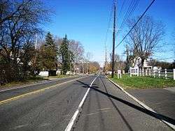
Along northbound Route 79 | |
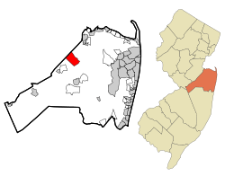 Map of Morganville CDP in Monmouth County. Inset: Location of Monmouth County in New Jersey. | |
| Coordinates: 40°22′31″N 74°13′58″W / 40.375327°N 74.23281°WCoordinates: 40°22′31″N 74°13′58″W / 40.375327°N 74.23281°W | |
| Country |
|
| State |
|
| County | Monmouth |
| Township | Marlboro |
| Area[1] | |
| • Total | 5.429 sq mi (14.061 km2) |
| • Land | 5.423 sq mi (14.045 km2) |
| • Water | 0.006 sq mi (0.016 km2) 0.11% |
| Elevation[2] | 190 ft (58 m) |
| Population (2010 Census)[3] | |
| • Total | 5,040 |
| • Density | 929.4/sq mi (358.8/km2) |
| Time zone | Eastern (EST) (UTC-5) |
| • Summer (DST) | Eastern (EDT) (UTC-4) |
| ZIP code | 07751[4] |
| Area code(s) | 732/848 |
| FIPS code | 3448030[1][5] |
| GNIS feature ID | 02389505[1][6] |
Morganville is an unincorporated community and census-designated place (CDP) within Marlboro Township, in Monmouth County, New Jersey, United States.[7][8][9] As of the 2010 United States Census, the CDP's population was 5,040.[3]
Morganville has its own post office, with a ZIP code of 07751.[4]
Geography
According to the United States Census Bureau, Morganville had a total area of 5.429 square miles (14.061 km2), including 5.423 square miles (14.045 km2) of land and 0.006 square miles (0.016 km2) of water (0.11%).[1][10]
Demographics
| Historical population | |||
|---|---|---|---|
| Census | Pop. | %± | |
| 1990 | 9,841 | — | |
| 2000 | 11,255 | 14.4% | |
| 2010 | 5,040 | −55.2% | |
| Population sources: 1990-2010[7] 2000[11] 2010[3] | |||
Census 2010
The 2010 United States Census counted 5,040 people, 1,526 households, and 1,370 families residing in the CDP. The population density was 929.4 per square mile (358.8/km2). The CDP contained 1,583 housing units at an average density of 291.9 per square mile (112.7/km2). The racial makeup of the CDP was 75.12% (3,786) White, 3.27% (165) Black or African American, 0.14% (7) Native American, 18.53% (934) Asian, 0.00% (0) Pacific Islander, 1.07% (54) from other races, and 1.87% (94) from two or more races. Hispanics or Latinos of any race were 5.00% (252) of the population.[3]
Out of a total of 1,526 households, 52.4% had children under the age of 18 living with them, 80.9% were married couples living together, 5.6% had a female householder with no husband present, and 10.2% were non-families. 8.1% of all households were made up of individuals, and 4.1% had someone living alone who was 65 years of age or older. The average household size was 3.29 and the average family size was 3.49.[3]
In the CDP, 30.7% of the population were under the age of 18, 6.5% from 18 to 24, 21.8% from 25 to 44, 32.6% from 45 to 64, and 8.4% who were 65 years of age or older. The median age was 40.7 years. For every 100 females the census counted 100.9 males, but for 100 females at least 18 years old, it was 98.8 males.[3]
Based on data from the Census Bureau's 2010-2014 American Community Survey, the median income for a household in the CDP was $119,215, and the median income for a family was $126,213. Males had a median income of $126,208 versus $62,326 for females. The per capita income for the CDP was $50,942. About 0.9% of families and 0.7% of the population were below the poverty line, including 0.8% of those under age 18 and 0.0% of those age 65 or over.[12]
Census 2000
As of the 2000 United States Census[5] there were 11,255 people, 3,642 households, and 3,270 families residing in the CDP. The population density was 1,892.0 people per square mile (730.3/km2). There were 3,723 housing units at an average density of 625.8/sq mi (241.6/km2). The racial makeup of the CDP was 87.27% White, 1.71% African American, 0.01% Native American, 9.76% Asian, 0.04% Pacific Islander, 0.50% from other races, and 0.71% from two or more races. Hispanic or Latino of any race were 2.94% of the population.[11]
There were 3,642 households out of which 45.0% had children under the age of 18 living with them, 82.1% were married couples living together, 6.2% had a female householder with no husband present, and 10.2% were non-families. 8.9% of all households were made up of individuals and 4.2% had someone living alone who was 65 years of age or older. The average household size was 3.09 and the average family size was 3.29.[11]
In the CDP the population was spread out with 27.9% under the age of 18, 5.9% from 18 to 24, 26.0% from 25 to 44, 32.2% from 45 to 64, and 8.1% who were 65 years of age or older. The median age was 40 years. For every 100 females there were 95.3 males. For every 100 females age 18 and over, there were 91.4 males.[11]
The median income for a household in the CDP was $99,035, and the median income for a family was $107,081. Males had a median income of $75,067 versus $41,861 for females. The per capita income for the CDP was $39,802. About 1.3% of families and 1.7% of the population were below the poverty line, including 1.1% of those under age 18 and 0.8% of those age 65 or over.[11]
Transportation
New Jersey Transit offers bus service to the Port Authority Bus Terminal in Midtown Manhattan on the 135 route.[13]
Education
As Morganville is located in Marlboro Township, students in public school are served by the Marlboro Township Public School District.
Wineries
Notable people
People who were born in, residents of, or otherwise closely associated with Morganville include;
- Jeff Feuerzeig (born 1964), film screenwriter and director.[14]
References
- 1 2 3 4 Gazetteer of New Jersey Places, United States Census Bureau. Accessed July 21, 2016.
- ↑ U.S. Geological Survey Geographic Names Information System: Morganville Census Designated Place, Geographic Names Information System. Accessed August 8, 2012.
- 1 2 3 4 5 6 DP-1 - Profile of General Population and Housing Characteristics: 2010 Demographic Profile Data for Morganville CDP, New Jersey, United States Census Bureau. Accessed August 8, 2012.
- 1 2 Look Up a ZIP Code for Morganville, NJ, United States Postal Service. Accessed August 8, 2012.
- 1 2 American FactFinder, United States Census Bureau. Accessed September 4, 2014.
- ↑ US Board on Geographic Names, United States Geological Survey. Accessed September 4, 2014.
- 1 2 New Jersey: 2010 - Population and Housing Unit Counts - 2010 Census of Population and Housing (CPH-2-32), United States Census Bureau, August 2012. Accessed December 16, 2012.
- ↑ GCT-PH1 - Population, Housing Units, Area, and Density: 2010 - County -- County Subdivision and Place from the 2010 Census Summary File 1 for Monmouth County, New Jersey, United States Census Bureau. Accessed December 16, 2012.
- ↑ Locality Search, State of New Jersey. Accessed April 19, 2015.
- ↑ US Gazetteer files: 2010, 2000, and 1990, United States Census Bureau. Accessed September 4, 2014.
- 1 2 3 4 5 DP-1 - Profile of General Demographic Characteristics: 2000 from the Census 2000 Summary File 1 (SF 1) 100-Percent Data for Morganville CDP, New Jersey, United States Census Bureau. Accessed August 8, 2012.
- ↑ DP03 SELECTED ECONOMIC CHARACTERISTICS from the 2010-2014 American Community Survey 5-Year Estimates for Morganville CDP, New Jersey, United States Census Bureau. Accessed July 6, 2016.
- ↑ Monmouth County Bus / Rail Connections, New Jersey Transit, backed up by the Internet Archive as of July 26, 2010. Accessed August 8, 2012.
- ↑ Falkenstein, Michelle. "From Maplewood To Sundance", The New York Times, January 30, 2005. Accessed August 10, 2012. "In 1988, Daniel Johnston, a songwriter, gave a legendary concert in Pier Platters, an independent Hoboken record store. He had a mental breakdown during the concert and ran amok for two weeks, said Jeff Feuerzeig, who grew up in Hazlet and Morganville and attended Trenton State College."
