New Monmouth, New Jersey
| New Monmouth, New Jersey | |
|---|---|
| Unincorporated community | |
 | |
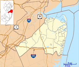 New Monmouth, New Jersey  New Monmouth, New Jersey  New Monmouth, New Jersey Location of New Monmouth in Monmouth County Inset: Location of county within the state of New Jersey | |
| Coordinates: 40°24′43″N 74°06′12″W / 40.41194°N 74.10333°WCoordinates: 40°24′43″N 74°06′12″W / 40.41194°N 74.10333°W | |
| Country |
|
| State |
|
| County | Monmouth |
| Township | Middletown |
| Elevation[1] | 36 ft (11 m) |
| Population (2010 Census)[2] | |
| • Total | 28,030 |
| ZIP code | 07748 |
| GNIS feature ID | 882519[1] |
New Monmouth is an unincorporated community located within Middletown Township in Monmouth County, New Jersey, United States.[3] The area is served as United States Postal Service ZIP code 07748.
As of the 2010 United States Census, the population for ZIP Code Tabulation Area 07748 was 28,030.[2] In the 2000 Census, the ZCTA population was 28,689.[4]
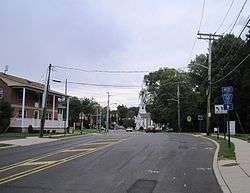
The public New Monmouth Elementary School and the parochial Mater Dei High School are located in New Monmouth. Most of the area is suburban, with single-family houses dotting the landscape. The two major roads that pass through New Monmouth are County Route 516 (Cherry Tree Farm Road and Leonardville Road) and New Monmouth Road (CR 50).[5]
References
- 1 2 "New Monmouth". Geographic Names Information System. United States Geological Survey.
- 1 2 DP-1; Profile of General Population and Housing Characteristics: 2010 from the 2010 Demographic Profile Data for ZCTA5 07748, United States Census Bureau. Accessed September 13, 2016.
- ↑ Locality Search, State of New Jersey. Accessed February 27, 2015.
- ↑ DP-1; Profile of General Demographic Characteristics: 2000 from the Census 2000 Summary File 1 (SF 1) 100-Percent Data for ZCTA5 07748 United States Census Bureau. Retrieved September 13, 2016.
- ↑ Google (September 13, 2016). "Aerial view of New Monmouth" (Map). Google Maps. Google. Retrieved September 13, 2016.
