Red Valley, New Jersey
| Red Valley, New Jersey | |
|---|---|
| Unincorporated community | |
|
Along Red Valley Road | |
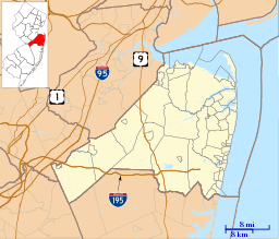 Red Valley, New Jersey  Red Valley, New Jersey  Red Valley, New Jersey Location of Red Valley in Monmouth County Inset: Location of county within the state of New Jersey | |
| Coordinates: 40°09′42″N 74°28′14″W / 40.16167°N 74.47056°WCoordinates: 40°09′42″N 74°28′14″W / 40.16167°N 74.47056°W | |
| Country |
|
| State |
|
| County | Monmouth |
| Township | Upper Freehold |
| Elevation[1] | 148 ft (45 m) |
| Time zone | Eastern (EST) (UTC-5) |
| • Summer (DST) | EDT (UTC-4) |
| GNIS feature ID | 879642[1] |

Red Valley is an unincorporated community located within Upper Freehold Township in Monmouth County, New Jersey, United States.[2] The settlement is located at the intersection of County Route 526 and Red Valley Road (south) and Yellow Meetinghouse Road (north) near the township's eastern border with Millstone Township. Except for some single-family houses located along the roads in the area, the area is primarily made up of farmland (both agricultural and horse farms).[3]
References
- 1 2 "Red Valley". Geographic Names Information System. United States Geological Survey.
- ↑ Locality Search, State of New Jersey. Accessed February 28, 2015.
- ↑ Google (November 28, 2015). "Aerial view of Red Valley" (Map). Google Maps. Google. Retrieved November 28, 2015.

This article is issued from Wikipedia - version of the 6/9/2016. The text is available under the Creative Commons Attribution/Share Alike but additional terms may apply for the media files.