Morrells Corner, New Jersey
| Morrells Corner, New Jersey | |
|---|---|
| Unincorporated community | |
|
Heading north on Holmdel Road (CR 4) approaching Bethany Road | |
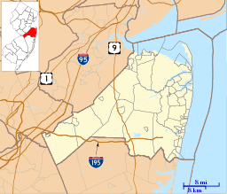 Morrells Corner, New Jersey  Morrells Corner, New Jersey  Morrells Corner, New Jersey Location of Morrells Corner in Monmouth County Inset: Location of county within the state of New Jersey | |
| Coordinates: 40°24′40″N 74°11′26″W / 40.41111°N 74.19056°WCoordinates: 40°24′40″N 74°11′26″W / 40.41111°N 74.19056°W | |
| Country |
|
| State |
|
| County | Monmouth |
| Township | Holmdel, Hazlet |
| Elevation[1] | 92 ft (28 m) |
| GNIS feature ID | 878481[1] |

Morrells Corner or Morrell Corners is an unincorporated community located within Holmdel and Hazlet townships in Monmouth County, New Jersey, United States.[2] The main north-south road through here is Holmdel Road (County Route 4) and the main east-west road is Bethany Road (also where the township line runs). Most of the area is suburban and consists of homes alongside roads with some businesses and the Hazlet NJ Transit station along the main roads.[3]
References
- 1 2 "Morrell Corners". Geographic Names Information System. United States Geological Survey.
- ↑ Locality Search, State of New Jersey. Accessed February 27, 2015.
- ↑ Google (March 31, 2016). "Aerial view of Morrells Corner" (Map). Google Maps. Google. Retrieved March 31, 2016.

This article is issued from Wikipedia - version of the 6/9/2016. The text is available under the Creative Commons Attribution/Share Alike but additional terms may apply for the media files.