Montrose, New Jersey
| Montrose, New Jersey | |
|---|---|
| Unincorporated community | |
|
Dutch Lane Road approaching Boundary Road | |
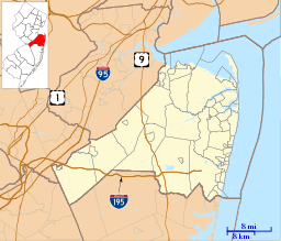 Montrose, New Jersey  Montrose, New Jersey  Montrose, New Jersey Location of Montrose in Monmouth County Inset: Location of county within the state of New Jersey | |
| Coordinates: 40°18′06″N 74°13′17″W / 40.30167°N 74.22139°WCoordinates: 40°18′06″N 74°13′17″W / 40.30167°N 74.22139°W | |
| Country |
|
| State |
|
| County | Monmouth |
| Township | Colts Neck and Marlboro |
| Elevation[1] | 157 ft (48 m) |
| Time zone | Eastern (EST) (UTC-5) |
| • Summer (DST) | EDT (UTC-4) |
| GNIS feature ID | 878453[1] |

Montrose is an unincorporated community located near the intersection of Dutch Lane Road (County Route 46) and Boundary Road along the border of Colts Neck and Marlboro townships in Monmouth County, New Jersey, United States.[2][3] The historic one-room Montrose Schoolhouse, built before 1820, is located in the Colts Neck portion of the community.[4]
References
- 1 2 "Montrose". Geographic Names Information System. United States Geological Survey.
- ↑ Locality Search, State of New Jersey. Accessed February 27, 2015.
- ↑ Google (February 27, 2015). "Montrose, Marlboro Township, New Jersey" (Map). Google Maps. Google. Retrieved February 27, 2015.
- ↑ Jeffrey Moser, Living in Media, Montrose Schoolhouse, March 28, 2005

This article is issued from Wikipedia - version of the 6/9/2016. The text is available under the Creative Commons Attribution/Share Alike but additional terms may apply for the media files.