Cooleys Corner, New Jersey
| Cooleys Corner, New Jersey | |
|---|---|
| Unincorporated community | |
|
Site of the former intersection of Clarksburg and Imlaystown-Hightstown Roads | |
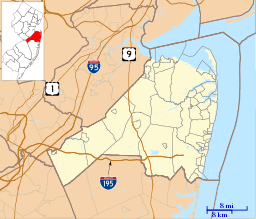 Cooleys Corner, New Jersey  Cooleys Corner, New Jersey  Cooleys Corner, New Jersey Location of Cooleys Corner in Monmouth County Inset: Location of county within the state of New Jersey | |
| Coordinates: 40°12′53″N 74°30′59″W / 40.21472°N 74.51639°WCoordinates: 40°12′53″N 74°30′59″W / 40.21472°N 74.51639°W | |
| Country |
|
| State |
|
| County | Monmouth |
| Township | Upper Freehold |
| Elevation[1] | 118 ft (36 m) |
| GNIS feature ID | 875624[1] |

Cooleys Corner is an unincorporated community located within Upper Freehold Township in Monmouth County, New Jersey, United States.[2] The site of the settlement is within the Assunpink Wildlife Management Area, a New Jersey Department of Environmental Protection Division of Fish and Wildlife-operated preserved area in Monmouth and Mercer counties along the Assunpink Creek. Before the creation of the Assunpink Lake in the 1970s, the area consisted of farmland located at the intersection of Clarksburg Road and Imlaystown-Hightstown Road.[3][4] Some farmland is still present in the area but is now mostly used by hunters. The main boat ramp to Assunpink Lake is located along the former Imlaystown-Hightstown Road.[5]
References
- 1 2 "Cooleys Corner". Geographic Names Information System. United States Geological Survey.
- ↑ Locality Search, State of New Jersey. Accessed February 21, 2015.
- ↑ Denicola, Linda (August 2, 2001). "Fish are for the taking at three Assunpink lakes". Allentown Examiner. Retrieved August 28, 2015.
The lakes are the products of the joint efforts of the U.S. Soil Conservation Service and the New Jersey Division of Fish and Wildlife as well as the New Jersey Green Acres Program. They were built around 1970 to provide flood protection for the Assunpink Creek, drainage, fish and wildlife habitats, and recreation.
- ↑ "Aerial view of Cooleys Corner". Historic Aerials. 1970. Retrieved August 28, 2015.
- ↑ Google (August 28, 2015). "Aerial view of Cooleys Corner" (Map). Google Maps. Google. Retrieved August 28, 2015.
