Collingwood Park, New Jersey
| Collingwood Park, New Jersey | |
|---|---|
| Unincorporated community | |
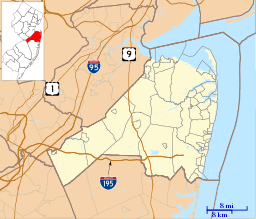 Collingwood Park  Collingwood Park  Collingwood Park Location of Collingwood Park in Monmouth County Inset: Location of county within the state of New Jersey | |
| Coordinates: 40°13′20″N 74°08′02″W / 40.22222°N 74.13389°WCoordinates: 40°13′20″N 74°08′02″W / 40.22222°N 74.13389°W | |
| Country |
|
| State |
|
| County | Monmouth |
| Township | Howell and Wall |
| Elevation[1] | 115 ft (35 m) |
| GNIS feature ID | 875563[1] |
Collingwood Park is an unincorporated community located along the border of Howell and Wall townships in Monmouth County, New Jersey, United States.[2][3]
Transportation
The Collingwood Circle is located in Collingwood Park, where Route 33 and Route 34, as well as County Route 547 intersect each other.[4]
References
- 1 2 "Collingwood Park". Geographic Names Information System. United States Geological Survey.
- ↑ Locality Search, State of New Jersey. Accessed February 21, 2015.
- ↑ Google (February 21, 2015). "Collingwood Park, New Jersey" (Map). Google Maps. Google. Retrieved February 21, 2015.
- ↑ Napoliton, Richard (1999). Wall Township. Arcadia Publishing. ISBN 073850162X.

This article is issued from Wikipedia - version of the 6/8/2016. The text is available under the Creative Commons Attribution/Share Alike but additional terms may apply for the media files.