Siloam, New Jersey
| Siloam, New Jersey | |
|---|---|
| Unincorporated community | |
|
Intersection of CR 527 and Ely Harmony Road | |
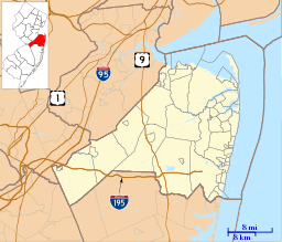 Siloam, New Jersey  Siloam, New Jersey  Siloam, New Jersey Location of Siloam in Monmouth County Inset: Location of county within the state of New Jersey | |
| Coordinates: 40°11′10″N 74°20′53″W / 40.18611°N 74.34806°WCoordinates: 40°11′10″N 74°20′53″W / 40.18611°N 74.34806°W | |
| Country |
|
| State |
|
| County | Monmouth |
| Township | Freehold |
| Elevation[1] | 144 ft (44 m) |
| Time zone | Eastern (EST) (UTC-5) |
| • Summer (DST) | EDT (UTC-4) |
| Area code(s) | 732/848 |
| GNIS feature ID | 880593[1] |

Siloam is an unincorporated community located within Freehold Township in Monmouth County, New Jersey, United States.[2] Siloam was once the site of a school serving a district in the township until 1936.[3] County Route 527 passes through the center of Siloam. Exit 21 on Interstate 195 provides access to Siloam from the south. Except around the center of the settlement at the junction of CR 527 and Ely Harmony Road, the area consists of forests comprising the northernmost reaches of the Pine Barrens. The homes in the area are smaller in size and are found only along the aforementioned roads.[4]
References
- 1 2 "Siloam". Geographic Names Information System. United States Geological Survey.
- ↑ Locality Search, State of New Jersey. Accessed March 4, 2015.
- ↑ "History of the Village of West Freehold". Freehold Township. Retrieved December 30, 2015.
There were eight school districts in the Township until 1936. They included ... Siloam District #10[.]
- ↑ Google (December 30, 2015). "Aerial view of Siloam" (Map). Google Maps. Google. Retrieved December 30, 2015.

This article is issued from Wikipedia - version of the 6/10/2016. The text is available under the Creative Commons Attribution/Share Alike but additional terms may apply for the media files.