Tupelo micropolitan area
| Tupelo µSA | |
|---|---|
| Micropolitan area | |
| Tupelo micropolitan statistical area | |
 | |
| Country | United States |
| State | Mississippi |
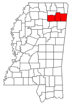
| Counties | Itawamba, Lee, Pontotoc |
| Area | |
| • Total | 1,494 sq mi (3,870 km2) |
| • Land | 1,479 sq mi (3,830 km2) |
| • Water | 16 sq mi (40 km2) |
| • Density | 5/sq mi (2/km2) |
| Time zone | CST (UTC-6) |
| • Summer (DST) | CDT (UTC-5) |
| Area code(s) | 662 |
The Tupelo Micropolitan Statistical Area is a micropolitan area in northeastern Mississippi that covers three counties - Itawamba, Lee and Pontotoc. As of the 2000 census, the μSA had a population of 125,251 (though a July 1, 2009 estimate placed the population at 134,161).[1]
Counties
Communities
Cities
Towns
- Algoma
- Ecru
- Guntown
- Mantachie
- Nettleton (partial)
- Plantersville
- Shannon
- Sherman (partial)
- Thaxton
- Toccopola
- Tremont
Unincorporated places
- Dorsey
- Eggville
- Fairview
- Mooreville
- Randolph
- Springville
- Troy
Demographics
As of the census[2] of 2000, there were 125,251 people, 48,070 households, and 34,881 families residing within the μSA. The racial makeup of the μSA was 79.37% White, 18.98% African American, 0.16% Native American, 0.37% Asian, 0.01% Pacific Islander, 0.47% from other races, and 0.64% from two or more races. Hispanic or Latino of any race were 1.27% of the population.
The median income for a household in the μSA was $33,125, and the median income for a family was $39,929. Males had a median income of $29,781 versus $21,495 for females. The per capita income for the μSA was $16,523.
See also
- List of metropolitan areas in Mississippi
- List of micropolitan areas in Mississippi
- List of cities in Mississippi
- List of towns and villages in Mississippi
- List of census-designated places in Mississippi
- List of United States metropolitan areas
References
- ↑ "Table 1. Annual Estimates of the Population of Metropolitan and Micropolitan Statistical Areas: April 1, 2000 to July 1, 2009 (CBSA-EST2009-01)" (CSV). 2009 Population Estimates. United States Census Bureau, Population Division. 2010-03-23. Retrieved 2010-03-29.
- ↑ "American FactFinder". United States Census Bureau. Retrieved 2008-01-31.
.svg.png)