Simpson County, Mississippi
| Simpson County, Mississippi | |
|---|---|
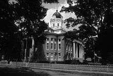 Simpson County courthouse in Mendenhall | |
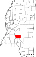 Location in the U.S. state of Mississippi | |
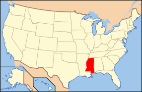 Mississippi's location in the U.S. | |
| Founded | 1824 |
| Seat | Mendenhall |
| Largest city | Magee |
| Area | |
| • Total | 590 sq mi (1,528 km2) |
| • Land | 589 sq mi (1,526 km2) |
| • Water | 1.3 sq mi (3 km2), 0.2% |
| Population | |
| • (2010) | 27,503 |
| • Density | 47/sq mi (18/km²) |
| Congressional district | 3rd |
| Time zone | Central: UTC-6/-5 |
Simpson County is a county located in the U.S. state of Mississippi. Its western border is formed by the Pearl River, an important transportation route in the 19th century. As of the 2010 census, the population was 27,503.[1] The county seat is Mendenhall.[2] The county is named for judge Josiah Simpson.
Simpson County is part of the Jackson, MS Metropolitan Statistical Area.
Spencer Myrick, a member of both houses of the Louisiana State Legislature, and his brother, Bill, a Country music figure in Odessa, Texas, were born in Simpson County. They were reared in West Carroll Parish in northeastern Louisiana.
Geography
According to the U.S. Census Bureau, the county has a total area of 590 square miles (1,500 km2), of which 589 square miles (1,530 km2) is land and 1.3 square miles (3.4 km2) (0.2%) is water.[3]
Major highways
-
 U.S. Highway 49
 -
 Mississippi Highway 13
 -
 Mississippi Highway 28
 -
 Mississippi Highway 43
 -
 Mississippi Highway 149
Adjacent counties
- Rankin County (north)
- Smith County (east)
- Covington County (southeast)
- Jefferson Davis County (south)
- Lawrence County (southwest)
- Copiah County (west)
Demographics
| Historical population | |||
|---|---|---|---|
| Census | Pop. | %± | |
| 1830 | 2,680 | — | |
| 1840 | 3,380 | 26.1% | |
| 1850 | 4,734 | 40.1% | |
| 1860 | 6,080 | 28.4% | |
| 1870 | 5,718 | −6.0% | |
| 1880 | 8,008 | 40.0% | |
| 1890 | 10,138 | 26.6% | |
| 1900 | 12,800 | 26.3% | |
| 1910 | 17,201 | 34.4% | |
| 1920 | 18,109 | 5.3% | |
| 1930 | 20,897 | 15.4% | |
| 1940 | 22,024 | 5.4% | |
| 1950 | 21,819 | −0.9% | |
| 1960 | 20,454 | −6.3% | |
| 1970 | 19,947 | −2.5% | |
| 1980 | 23,441 | 17.5% | |
| 1990 | 23,953 | 2.2% | |
| 2000 | 27,639 | 15.4% | |
| 2010 | 27,503 | −0.5% | |
| Est. 2015 | 27,222 | [4] | −1.0% |
| U.S. Decennial Census[5] 1790-1960[6] 1900-1990[7] 1990-2000[8] 2010-2013[1] | |||
As of the census [9] of 2000, there were 27,639 people, 10,076 households, and 7,385 families residing in the county. The population density was 47 people per square mile (18/km²). There were 11,307 housing units at an average density of 19 per square mile (7/km²). The racial makeup of the county was 64.39% White, 34.31% Black or African American, 0.12% Native American, 0.14% Asian, 0.01% Pacific Islander, 0.47% from other races, and 0.56% from two or more races. 1.15% of the population were Hispanic or Latino of any race.
There were 10,076 households out of which 34.80% had children under the age of 18 living with them, 54.20% were married couples living together, 14.80% had a female householder with no husband present, and 26.70% were non-families. 24.00% of all households were made up of individuals and 11.10% had someone living alone who was 65 years of age or older. The average household size was 2.65 and the average family size was 3.14.
In the county the population was spread out with 27.90% under the age of 18, 9.40% from 18 to 24, 27.50% from 25 to 44, 22.10% from 45 to 64, and 13.10% who were 65 years of age or older. The median age was 35 years. For every 100 females there were 94.40 males. For every 100 females age 18 and over, there were 90.40 males.
The median income for a household in the county was $28,343, and the median income for a family was $32,797. Males had a median income of $27,197 versus $20,136 for females. The per capita income for the county was $13,344. About 17.50% of families and 21.60% of the population were below the poverty line, including 25.70% of those under age 18 and 21.00% of those age 65 or over.
Communities
Cities
Town
Village
Unincorporated communities
Ghost town
See also
References
- 1 2 "State & County QuickFacts". United States Census Bureau. Retrieved September 5, 2013.
- ↑ "Find a County". National Association of Counties. Retrieved 2011-06-07.
- ↑ "2010 Census Gazetteer Files". United States Census Bureau. August 22, 2012. Retrieved November 7, 2014.
- ↑ "County Totals Dataset: Population, Population Change and Estimated Components of Population Change: April 1, 2010 to July 1, 2015". Retrieved July 2, 2016.
- ↑ "U.S. Decennial Census". United States Census Bureau. Retrieved November 7, 2014.
- ↑ "Historical Census Browser". University of Virginia Library. Retrieved November 7, 2014.
- ↑ "Population of Counties by Decennial Census: 1900 to 1990". United States Census Bureau. Retrieved November 7, 2014.
- ↑ "Census 2000 PHC-T-4. Ranking Tables for Counties: 1990 and 2000" (PDF). United States Census Bureau. Retrieved November 7, 2014.
- ↑ "American FactFinder". United States Census Bureau. Retrieved 2008-01-31.
 |
Rankin County | | ||
| Copiah County | |
Smith County | ||
| ||||
| | ||||
| Lawrence County | Jefferson Davis County | Covington County |
Municipalities and communities of Simpson County, Mississippi, United States | ||
|---|---|---|
| Cities | | |
| Town | ||
| Village | ||
| Unincorporated communities | ||
.svg.png)
Coordinates: 31°55′N 89°55′W / 31.92°N 89.92°W