Hancock County, Mississippi
| Hancock County, Mississippi | |
|---|---|
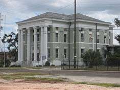 Hancock County courthouse in Bay St. Louis | |
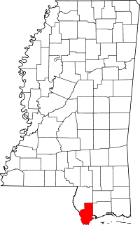 Location in the U.S. state of Mississippi | |
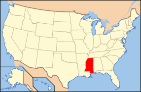 Mississippi's location in the U.S. | |
| Founded | 1812 |
| Named for | John Hancock |
| Seat | Bay St. Louis |
| Largest city | Bay St. Louis |
| Area | |
| • Total | 553 sq mi (1,432 km2) |
| • Land | 474 sq mi (1,228 km2) |
| • Water | 79 sq mi (205 km2), 14% |
| Population | |
| • (2010) | 43,929 |
| • Density | 93/sq mi (36/km²) |
| Congressional district | 4th |
| Time zone | Central: UTC-6/-5 |
| Website |
www |
Hancock County is the southernmost county of the U.S. state of Mississippi. As of the 2010 census, the population was 43,929.[1] Its county seat is Bay St. Louis.[2] The county is named for Founding Father John Hancock.[3]
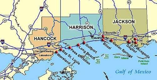
Hancock County is part of the Gulfport–Biloxi-Pascagoula, MS Metropolitan Statistical Area. It is situated along the Gulf of Mexico and the state line with Louisiana. The area is home to the John C. Stennis Space Center, NASA's largest rocket engine test facility.
The county was severely damaged from Hurricane Katrina on August 29, 2005, causing catastrophic effects.
History
In 2005, the county was the scene of the final landfall of the eye of Hurricane Katrina, and its communities and infrastructure suffered some of the most intense damage inflicted by that storm. Over the entire 7-mile (11 km) beach front, not one building or home was left intact. This is true for nearly the entire 1st block off of the beach for the entire 7-mile (11 km) stretch.
Homes as far inland as 10 miles (16 km) were flooded by the historic storm surge which occurred during a full moon high tide. All rivers and waterways were inundated by the surge. Highway 603 south from Interstate 10 was completely submerged, and the Highway 90 - Bay St. Louis Bridge was left looking like a stack of dominoes. Houses were floated off their foundations. In Waveland and Bay St. Louis some homes were left atop the railroad tracks and others in the middle of streets. Towns like Pearlington, Waveland, Bay St. Louis, Diamondhead, and Kiln suffered catastrophic damage.
Recovery from Hurricane Katrina
A loosely knit group of hippies called the "Rainbow Family" arrived in Hancock County soon after Hurricane Katrina. From early September 2005 to early December 2005, they ran the "New Waveland Cafe and Clinic" located in the parking lot of Fred's Dept Store on Highway 90. The café provided free hot meals three times a day. The clinic was staffed by volunteer doctors and nurses from around the United States who saw over 5000 patients during the duration, free of charge and dispensing free medications. Donations of medications and supplies came from a multitude of sources, with International Aid arranging the most donations. This was the first experience of the counter-culture Rainbow Family in running a disaster relief center. The Bastrop Christian Outreach Center also volunteered with the Rainbow Family.
Local churches were central points of recovery in Bay St. Louis, Waveland, and Diamondhead. Some churches provided shelter, meals, clothing, and various clean-up supplies. The churches also provided distribution points where supplies could be donated and easily passed on to those who needed help. Other disaster relief agencies that were active in Hancock County include Samaritan's Purse, Southern Baptist Convention Disaster Relief, Red Cross, Rotary International and Salvation Army.
Businesses became operational as quickly as possible. The Waveland Wal-Mart operated out of a tent for 3 months following the storm; Diamondhead Discount Drug was opened within 2 days following Katrina despite the owner's store and home damages. Other business like Dairy Queen and Subway donated their foodstuffs, before it could spoil, for feeding survivors.
Geography
According to the U.S. Census Bureau, the county has a total area of 553 square miles (1,430 km2), of which 474 square miles (1,230 km2) is land and 79 square miles (200 km2) (14%) is water.[4]
Major highways
Adjacent counties and parishes
- Pearl River County (north)
- Harrison County (east)
- St. Bernard Parish, Louisiana (south)
- St. Tammany Parish, Louisiana (west)
Demographics
| Historical population | |||
|---|---|---|---|
| Census | Pop. | %± | |
| 1820 | 1,594 | — | |
| 1830 | 1,962 | 23.1% | |
| 1840 | 3,367 | 71.6% | |
| 1850 | 3,672 | 9.1% | |
| 1860 | 3,139 | −14.5% | |
| 1870 | 4,239 | 35.0% | |
| 1880 | 6,439 | 51.9% | |
| 1890 | 8,318 | 29.2% | |
| 1900 | 11,886 | 42.9% | |
| 1910 | 11,207 | −5.7% | |
| 1920 | 10,380 | −7.4% | |
| 1930 | 11,415 | 10.0% | |
| 1940 | 11,328 | −0.8% | |
| 1950 | 11,891 | 5.0% | |
| 1960 | 14,039 | 18.1% | |
| 1970 | 17,387 | 23.8% | |
| 1980 | 24,537 | 41.1% | |
| 1990 | 31,760 | 29.4% | |
| 2000 | 42,967 | 35.3% | |
| 2010 | 43,929 | 2.2% | |
| Est. 2015 | 46,420 | [5] | 5.7% |
| U.S. Decennial Census[6] 1790-1960[7] 1900-1990[8] 1990-2000[9] 2010-2013[1] | |||
As of the census[10] of 2000, there were 42,967 people, 16,897 households, and 11,827 families residing in the county. The population density was 90 people per square mile (35/km²). There were 21,072 housing units at an average density of 44 per square mile (17/km²). The racial makeup of the county was 90.19% White, 6.83% Black or African American, 0.60% Native American, 0.88% Asian, 0.04% Pacific Islander, 0.33% from other races, and 1.14% from two or more races. 1.80% of the population were Hispanic or Latino of any race.
There were 16,897 households out of which 31.50% had children under the age of 18 living with them, 53.90% were married couples living together, 11.30% had a female householder with no husband present, and 30.00% were non-families. 24.70% of all households were made up of individuals and 9.20% had someone living alone who was 65 years of age or older. The average household size was 2.52 and the average family size was 2.99.
In the county the population was spread out with 25.10% under the age of 18, 7.30% from 18 to 24, 28.00% from 25 to 44, 25.60% from 45 to 64, and 14.00% who were 65 years of age or older. The median age was 38 years. For every 100 females there were 98.30 males. For every 100 females age 18 and over, there were 95.50 males.
The median income for a household in the county was $35,202, and the median income for a family was $40,307. Males had a median income of $32,229 versus $22,066 for females. The per capita income for the county was $17,748. About 11.20% of families and 14.40% of the population were below the poverty line, including 17.90% of those under age 18 and 10.30% of those age 65 or over.
Hancock County has the eighth highest per capita income in the State of Mississippi.
Communities
Cities
- Bay St. Louis (county seat)
- Diamondhead
- Waveland
Census-designated places
Unincorporated communities
See also
References
- 1 2 "State & County QuickFacts". United States Census Bureau. Retrieved September 3, 2013.
- ↑ "Find a County". National Association of Counties. Retrieved 2011-06-07.
- ↑ Gannett, Henry (1905). The Origin of Certain Place Names in the United States. Govt. Print. Off. p. 148.
- ↑ "2010 Census Gazetteer Files". United States Census Bureau. August 22, 2012. Retrieved November 4, 2014.
- ↑ "County Totals Dataset: Population, Population Change and Estimated Components of Population Change: April 1, 2010 to July 1, 2015". Retrieved July 2, 2016.
- ↑ "U.S. Decennial Census". United States Census Bureau. Retrieved November 4, 2014.
- ↑ "Historical Census Browser". University of Virginia Library. Retrieved November 4, 2014.
- ↑ "Population of Counties by Decennial Census: 1900 to 1990". United States Census Bureau. Retrieved November 4, 2014.
- ↑ "Census 2000 PHC-T-4. Ranking Tables for Counties: 1990 and 2000" (PDF). United States Census Bureau. Retrieved November 4, 2014.
- ↑ "American FactFinder". United States Census Bureau. Retrieved 2008-01-31.
External links
 |
Pearl River County | | ||
| St. Tammany Parish, Louisiana | |
Harrison County | ||
| ||||
| | ||||
| Gulf of Mexico |
Municipalities and communities of Hancock County, Mississippi, United States | ||
|---|---|---|
| Cities | | |
| CDPs | ||
| Unincorporated communities | ||
.svg.png)
Coordinates: 30°23′N 89°28′W / 30.39°N 89.47°W