Oxford, Mississippi
| Oxford, | |
|---|---|
| City | |
|
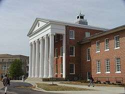
University of Mississippi, a.k.a. "Ole Miss". | |
 Location of Oxford, Mississippi | |
 Oxford, Location in the United States | |
| Coordinates: 34°21′35″N 89°31′34″W / 34.35972°N 89.52611°WCoordinates: 34°21′35″N 89°31′34″W / 34.35972°N 89.52611°W | |
| Country | United States |
| State | Mississippi |
| County | Lafayette |
| Government | |
| • Mayor | George "Pat" Patterson (D) |
| Area | |
| • Total | 10.0 sq mi (25.8 km2) |
| • Land | 10.0 sq mi (25.8 km2) |
| • Water | 0.0 sq mi (0.0 km2) |
| Elevation | 505 ft (154 m) |
| Population (2014) | |
| • Total | 21,757 |
| • Density | 1,179.1/sq mi (455.3/km2) |
| Time zone | Central (CST) (UTC-6) |
| • Summer (DST) | CDT (UTC-5) |
| ZIP code | 38655 |
| Area code(s) | 662 |
| FIPS code | 28-54840 |
| GNIS feature ID | 0691644 |
Oxford is a city in, and the county seat of, Lafayette County, Mississippi, United States. Founded in 1837, it was named after the British university city of Oxford in hopes of having the state university located there, which it did successfully attract.
As of the 2010 US Census, the population is 18,916; the Census Bureau estimates the city's 2013 population at 20,865.[1] Oxford is the home of the University of Mississippi, founded in 1848, also commonly known as "Ole Miss".
Oxford has been named by USA Today as one of the top six college towns in the nation. It is included in The Best 100 Small Towns in America. Lafayette County consistently leads the state rankings in the lowest unemployment rate per quarter. Oxford City Schools are ranked as "Star" schools, the highest ranking available, and Lafayette County school systems are consistently ranked as "5-star" systems.
History
Oxford and Lafayette County were formed from lands ceded by the Chickasaw in the treaty of Pontotoc Creek in 1832. The county was organized in 1836, and in 1837 three pioneers—John Martin, John Chisom, and John Craig—purchased land from Hoka, a female Chickasaw landowner, as a site for the town.[2] They named it Oxford, intending to promote it as a center of learning in the Old Southwest. In 1841, the Mississippi legislature selected Oxford as the site of the state university, which opened in 1848.
During the American Civil War, Oxford suffered invasion by federal troops under Generals Ulysses S. Grant and William T. Sherman in 1862; in 1864 Major General Andrew Jackson Smith burned the buildings in the town square, including the county courthouse. In the postwar Reconstruction Era, the town recovered slowly, aided by federal judge Robert Andrews Hill, who secured funds to build a new courthouse in 1872. During this period many African American freedmen moved from farms into town and established a neighborhood known as "Freedmen Town", where they built houses, businesses, churches and schools, and exercised all the rights of citizenship.[3] Even after Mississippi disfranchised most African Americans in the Constitution of 1890, they continued to build their lives in the face of discrimination.
During the Civil Rights Movement, Oxford drew national attention in the Ole Miss riot of 1962. State officials, including Governor Ross Barnett, prevented James Meredith, an African American, from enrolling at the University of Mississippi, even after the federal courts had ruled that he be admitted. In late September 1962, President John F. Kennedy, following secret face-saving negotiations with Barnett, ordered United States Marshals to accompany Meredith, while Barnett agreed to use Highway State Police to keep the peace. Thousands of armed "volunteers" flowed into the Oxford area. Meredith traveled to Oxford under armed guard to register, but riots by segregationists broke out in protest of his admittance. That evening, cars were burned, federal marshals were pelted with rocks, bricks and small arms fire, and university property was damaged by three thousand rioters. Two men were killed by gunshot wounds. The riot spread into adjacent areas of the city of Oxford.[4] Order was finally restored to the campus with the early morning arrival of nationalized Mississippi National Guard and regular U.S. Army units, who camped in the City.[5]
More than 3000 journalists came to Oxford on September 26, 2008 to cover the first presidential debate of 2008, which was held at the University of Mississippi.[6]
Geography
Oxford is within 100 miles of Memphis, Tennessee.
According to the United States Census Bureau, the city has a total area of 10.0 square miles (26 km2), of which, 10.0 square miles (26 km2) of it is land and 0.10% is water.
The city is located in the North Central Hills region of Mississippi. The region is known for its heavily forested hills made up of red clay. The area is higher and greater in relief than areas to the west (such as the Mississippi Delta or loess bluffs along the Delta), but lower in elevation than areas in Northeast Mississippi. The changes in elevation can really be noticed when traveling on the Highway 6 bypass since the east-west highway tends to transect many of the north-south ridges. Downtown Oxford sits on one of these ridges and the University of Mississippi sits on another one, while the main commercial corridors on either side of the city sit in valleys.
Oxford is located at the confluence of highways from eight directions: Mississippi Highway 6 (now co-signed with US-278) runs west to Batesville and east to Pontotoc; Highway 7 runs north to Holly Springs and south to Water Valley. Highway 30 goes northeast to New Albany; highway 334 ("Old Highway 6") southeast to Toccopola; Taylor Road southwest to Taylor, and highway 314 ("Old Sardis Road") northwest, formerly to Sardis but now to the Clear Creek Recreation Area on Sardis Lake.
The streets in the downtown area follow a grid pattern with two naming conventions. Many of the north-south streets are numbered from west to east, beginning at the old railroad depot, with numbers from four to nineteen. The place of "Twelfth Street," however, is taken by North and South Lamar Boulevard (formerly North and South Streets). The east-west avenues are named for the U.S. presidents in chronological order from north to south, from Washington to Cleveland; here again, there are gaps: John Quincy Adams would be indistinguishable from John Adams; "Polk Avenue" is replaced by University Avenue, and "Arthur Avenue" is lacking.
Demographics
| Historical population | |||
|---|---|---|---|
| Census | Pop. | %± | |
| 1850 | 492 | — | |
| 1870 | 1,422 | — | |
| 1880 | 1,534 | 7.9% | |
| 1890 | 1,546 | 0.8% | |
| 1900 | 1,825 | 18.0% | |
| 1910 | 2,014 | 10.4% | |
| 1920 | 2,150 | 6.8% | |
| 1930 | 2,890 | 34.4% | |
| 1940 | 3,433 | 18.8% | |
| 1950 | 3,956 | 15.2% | |
| 1960 | 5,283 | 33.5% | |
| 1970 | 8,519 | 61.3% | |
| 1980 | 9,882 | 16.0% | |
| 1990 | 9,984 | 1.0% | |
| 2000 | 11,756 | 17.7% | |
| 2010 | 18,916 | 60.9% | |
| Est. 2015 | 22,314 | [7] | 18.0% |
| U.S. Decennial Census[8] 1920-1930[9] | |||
As of the census[10] of 2010, there were 18,916 people, with 8,648 households residing in the city. The racial makeup of the city was 72.3% White, 21.8% African American, 0.3% Native American, 3.3% Asian, 0.1% Pacific Islander, and 1.1% from two or more races. Hispanic or Latino of any race were 2.5% of the population. The average household size was 2.09.
The median income for a household in the city was $38,872, and the average household income was $64,643. The per capita income for the city was $29,195.[11] About 12% of families and 32.3% of the population were below the poverty line.
Education
The City of Oxford is served by two public school districts, Oxford School District and Lafayette County School District, and three private schools, Oxford University School, Regents School and Magnolia Montessori. Oxford is partially the home of the main campus of the University of Mississippi, known as "Ole Miss" (much of the campus is in University, Mississippi, an unincorporated enclave surrounded by the City of Oxford), and of the Lafayette-Yalobusha Center of Northwest Mississippi Community College. The North Mississippi Japanese Supplementary School, a Japanese weekend school, is operated in conjunction with the University of Mississippi, with classes held on campus.[12][13]
Health care
The Baptist Memorial Hospital - North Mississippi, located in Oxford provides comprehensive health care services for Oxford and the surrounding area, supported by a growing number of physicians, clinics and support facilities. The North Mississippi Regional Center, a state-licensed Intermediate Care Facility for Individuals with Intellectual Disabilities (ICF/IID), is located in Oxford.
Oxford is home to the National Center for Natural Products Research at the University of Mississippi's School of Pharmacy. The Center is the only facility in the United States that is federally licensed to cultivate marijuana for scientific research, and for distribution to patients who are allowed marijuana for medical purposes.
Transportation
The City of Oxford operates public transportation under the name Oxford-University Transit (OUT), with bus routes throughout the city and University of Mississippi campus.[14] Ole Miss students and faculty ride free upon showing University identification.
University-Oxford Airport serves the Lafayette-Oxford-University area. Southern Airways Express provides passenger service to New Orleans, Destin, Florida, and Panama City, Florida.
Mississippi Central Railroad provides freight rail service to the Lafayette County Industrial Park in Oxford.
Notable people

- William Faulkner adopted Oxford as his hometown after growing up there when his family moved to Oxford from nearby New Albany when he was three. Oxford is the model for the city "Jefferson" in his fiction, and Lafayette County, Mississippi, was the model for his fictional Yoknapatawpha County. His former home, Rowan Oak, now owned by the University of Mississippi and recently remodeled, is a favorite tourist attraction in Oxford. Several members of Faulkner's family still live in the Oxford and Lafayette County area.
- John Grisham also has a home in Oxford. He received a J.D. from the University of Mississippi School of Law in 1981 and practiced law in the Mississippi suburbs of Memphis for ten years before retiring to write full-time. He and his family relocated to Oxford in the early 1990s. Mr. Grisham still maintains a home in Oxford but his primary residence is now in Charlottesville, Virginia.
- Curtis Wilkie, Ace Atkins, Chris Offutt, Tom Franklin, Beth Ann Fennelly, Ann Fisher-Wirth, Neil White, Wright Thompson and New Yorker staff writer and author Paige Williams are among the many acclaimed writers who have lived in Oxford. Acclaimed deceased authors Stark Young, Larry Brown, Willie Morris, and Barry Hannah also called Oxford home. Howard Bahr and Richard Ford also lived in Oxford for an extended period.
- Oxford has been called the art center of the South. Famous artists include photorealist painter Glennray Tutor; figurative painter Jere Allen; expressionist painter Paula Temple; portraitist Jason Bouldin, sculptor William Beckwith; sculptor Rod Moorhead; and primitive artist Theora Hamblett (1895–1977). New Orleans artist John McCrady (1911–1968) studied art at Ole Miss.
- Secretary of the Interior Jacob Thompson (1810–1885) owned a manor called "Home Place" in Oxford that was burned down in 1864 during the Civil War by Union troops. A historical marker stands on the spot where it once stood.
- L.Q.C. Lamar (1825–1893), U.S. senator and supreme court justice, resided in Oxford, where he served as professor of mathematics at the University of Mississippi, farmed, and practiced law. He was the son-in-law of university chancellor Augustus Baldwin Longstreet. Lamar's home in Oxford has recently been restored (2008) as a museum.
- Naomi Sims (1948-2009), fashion model, was born in Oxford.
- New York Giants quarterback Eli Manning, who played college football at Ole Miss, lives in Oxford during the offseason. His father, former Ole Miss and New Orleans Saints quarterback Archie Manning, owns a condominium in Oxford.
Attractions
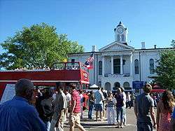
- The courthouse square, called "The Square", is the geographic and cultural center of the city. In addition to the historic Lafayette County Courthouse, the Square is known for an abundance of locally owned restaurants, specialty boutiques, and professional offices, along with Oxford City Hall.
- The J. E. Neilson Co., located on the southeast corner of the square is the South's oldest documented store. Founded as a trading post in 1839, Neilson's continues to anchor the Oxford square. When the Great Depression hit Oxford and most of the banks in town closed, Neilson's acted as a surrogate bank, cashing paychecks for university employees and others.
- Square Books, a local bookstore founded in 1979, is consistently ranked among the best independent bookstores in the country. A sister store, Off Square Books, which is several doors down the street to the east, deals in used and remainder books and is the venue for a radio show called Thacker Mountain Radio, with host Jim Dees, that is broadcast statewide on Mississippi Public Broadcasting. The show often draws comparisons to Garrison Keillor's A Prairie Home Companion for its mix of author readings and musical guests. A third store, Square Books Jr., deals exclusively in children's books and educational toys.
- The Lyric Theater, just off the courthouse square, is Oxford's largest music venue, with a capacity near 1200. Originally built in the late 1800s, the structure became a livery stable owned by William Faulkner’s family in the early part of the 20th century. During the 1920s it became Oxford's first motion picture theater, the Lyric. In 1949, Faulkner walked from his home in Oxford to his childhood stable for the world premiere of MGM’s Intruder in the Dust, adapted from one of his novels. Abandoned for many years, the building housed office space and a health center from the early 1980s. After extensive restoration, the Lyric reopened on 3 July 2008 as a live music venue. It also is used occasionally for film and live drama.
- The Gertrude Castellow Ford Center for the Performing Arts on the University of Mississippi's campus hosts a broad range of events, such as symphony performances, operas, musicals, plays, comedy tours, chamber music, and guest lectures.
Cultural
- Oxford has had a thriving and diverse music scene for many years, often drawing comparisons to other Southern college towns with active musical life, such as Charlottesville, Virginia; Chapel Hill, North Carolina; Gainesville, Florida; Austin, Texas; or Athens, Georgia. Oxford's relatively close proximity to large music cities such as Memphis, New Orleans, and Nashville, make it a regular stop for most of the current musicians and bands who tour on a regular basis. Musicians past and present living in Oxford include Beanland, The Cooters, Bass Drum of Death, Kudzu Kings, Blue Mountain, George McConnell, Caroline Herring and blues harp player Adam Gussow.
- Oxford is also the home of the renegade blues label Fat Possum Records, who released records by blues legends R. L. Burnside and Junior Kimbrough, as well as The Black Keys. Johnny Marr, former guitarist for The Smiths and current member of Modest Mouse bought a home in Oxford but no longer lives in it. Former Derek and the Dominos member Bobby Whitlock lived in Oxford where he had a ranch and his own studio.
- Musicians Modest Mouse, Gavin Degraw, Elvis Costello, The Hives, and Counting Crows have recorded albums at Sweet Tea Recording Studio in Oxford. Dennis Herring, the owner of Sweet Tea, has received Grammy awards for his work with artists such as Jars of Clay and blues great Buddy Guy.
- Bob Dylan wrote a song called "Oxford Town", which was included on his album The Freewheelin' Bob Dylan. The song was about the violent events surrounding the admission of James Meredith into the University of Mississippi in 1962. Dylan played a memorable concert at the Tad Smith Coliseum on the Ole Miss campus in November 1990, which opened with a performance of the song Oxford Town.
- Oxford has been the setting for numerous movies, including Intruder in the Dust (1949, based on the Faulkner novel), Home from the Hill (1960), Barn Burning (1980, based on the Faulkner short story), Rush (1981 documentary), Heart of Dixie (1989), The Gun in Betty Lou's Handbag (1992), Sorry, We're Open (2008 documentary), The Night of the Loup Garou (2009), Where I Begin (2010), and parts of The People vs. Larry Flynt (1997).
Historic sites
See also National Register of Historic Places listings in Lafayette County, Mississippi[15] and the Lyceum-The Circle Historic District, University of Mississippi.
- Ammadelle (Pegues House), 637 N. Lamar Blvd., 1859, designed by Calvert Vaux
- Beanland-Young House, 812 S. Lamar Blvd., ca. 1905 (Prairie style)
- Barnard Observatory (Center for the Study of Southern Culture), University of Mississippi, 1859
- Cedar Oaks (William Turner house), 1858, moved to present location
- Culley-East Bungalow, 904 S. Lamar Blvd., 1921 (Craftsman style)
- Eades-Thompson House, 1106 S. Lamar Blvd., ca. 1858
- J.W.T. Falkner, Jr. House, 706 S. Lamar Blvd., 1902
- Maud Falkner House, 510 S. Lamar Blvd., 1932
- Fiddler's Folly (Howry-Hill House), 520 N. Lamar Blvd., 1878, designed by James Stewart[16]
- First Presbyterian Church, 924 Van Buren Ave., 1881, attributed to G. M. Torgerson
- The Flamingo, University Ave., 1937, designed by James T. Canizaro (Art Deco)
- Gatekeeper's Lodge, 802 Old Taylor Rd., ca. 1847
- Howry-Wright House, 824 University Ave., 1858
- Illinois Central Depot, 1872[17]
- Isom Place, 1003 Jefferson Ave., ca. 1843, remodeled 1848
- Kennedy-Shaw House, 1701 Jackson Ave., 1848
- Lafayette County Courthouse, 1872, designed by Willis, Sloan, and Trigg
- Lucius Q. C. Lamar House, 616 N. 14th St., ca. 1860
- Lindfield (Craig House), 1215 S. 11th St., ca. 1837
- Longstreet-Carter House, 634 N. Lamar Blvd., ca. 1865
- The Lyceum, University of Mississippi, 1848, designed by William Nichols
- The Magnolias (Smither-Pegues House), 1012 University Ave., ca. 1842
- Meek-Duvall House, 803 University Ave., 1878
- Memory House (John Faulkner House), 406 University Ave., ca. 1855, remodeled 1880s
- Oxford City Hall (former Federal Courthouse), 1885 (Richardson Romanesque)
- Eliza Pegues House, 535 N. Lamar Blvd., ca. 1876
- Puddin' Place (Yates House), 1008 University Ave., 1892
- Roberts-Neilson House, 911 S. Lamar Blvd., ca. 1870, attributed to G. M. Torgerson
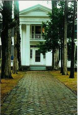
- Rowan Oak (William Faulkner House), 1848
- St. Peter's Cemetery, 1871
- St. Peter's Episcopal Church, 113 9th St., 1860, attributed to Richard Upjohn (Neo-Gothic)
- Shadowlawn (Neilson-Culley house), 712 S. 11th St., 1859, designed by William Turner
- Stone-Freeland law office, 1013 Jackson Ave., ca. 1890
- Theora Hamblett House, 619 Van Buren Ave., ca. 1875, designed by G. M. Torgerson
- Thompson-Chandler House, 923 S. 13th St., ca. 1837
- Thompson-Elliott House, 910 Old Taylor Rd., ca. 1869
- Thompson Hotel, 1870
- Trigg-Doyle-Falkner House, 910 Buchanan Ave., ca. 1855
- University of Mississippi Power House, site of William Faulkner's composition of As I Lay Dying
- Stowers-Longest House, 1003 S. Lamar Blvd., ca. 1895
- Ventress Hall, University of Mississippi, 1889 (Richardson Romanesque)
- Walton-Young House, University Ave., ca. 1880
- Thomas Wendel House, 1005 Jackson Ave., ca. 1848
- Y Building (Croft Institute for International Studies), University of Mississippi, 1853
Twin town
References
- ↑ "State & County QuickFacts". United States Census Bureau. Retrieved August 15, 2014.
- ↑ Jack Lamar Mayfield. Oxford and Ole Miss. Arcadia Publishing, 2009, p. 7.
- ↑ Freedmen Town, Lafayette County, History Markers of Mississippi, accessed 30 May 2008,
- ↑ Doyle, William. An American Insurrection: James Meredith and the Battle of Oxford, Mississippi, 1962. New York: Anchor Books, 2003.
- ↑ Eagles. Charles W. "'The Fight for Men's Minds': The Aftermath of the Ole Miss Riot of 1962" http://mdah.state.ms.us/new/wp-content/uploads/2013/07/riot.pdf
- ↑ 2008 Presidential Debate | The University of Mississippi - Official Home Page
- ↑ "Annual Estimates of the Resident Population for Incorporated Places: April 1, 2010 to July 1, 2015". Retrieved July 2, 2016.
- ↑ "U.S. Decennial Census". United States Census Bureau. Retrieved June 13, 2015.
- ↑ "Historical Census Browser". University of Virginia Library. Retrieved June 13, 2015.
- ↑ "American FactFinder". United States Census Bureau. Retrieved 2008-01-31.
- ↑ Oxford, MS Household Income Statistics. CLRSearch. Retrieved on 2013-08-17.
- ↑ "Japanese Supplementary School." OGE-US Japan Partnership, University of Mississippi. Retrieved on February 25, 2015.
- ↑ "周辺案内." North Mississippi Japanese Supplementary School at The University of Mississippi. Retrieved on April 1, 2015.
- ↑ http://www.oxfordms.net/visitors/transit/bus-routes-a-schedules.html
- ↑ Thomas S. Hines, William Faulkner and the Tangible Past: The Architecture of Yoknapatawpha (University of California Press, 1997) http://publishing.cdlib.org/ucpressebooks/view?docId=ft0z09n7jz&chunk.id=0&doc.view=print
- ↑ http://www.oxfordcvb.com/docs/OxfordWalkingTourbrochure_2011.pdf
- ↑ Oxford Depot - History. Olemiss.edu (2003-08-26). Retrieved on 2013-08-17.
- ↑ Schnugg, Alyssa. ""Sister Cities"". Oxford Eagle. Retrieved December 12, 2014.
External links
- City of Oxford Official Website
- Oxford-Lafayette County Chamber of Commerce
- Oxford Tourism Council
- Yoknapatawpha Arts Council
- Oxford Conference Center
- Oxford Cultural Heritage Inventory
- Oxford Civic Chorus Web Site
- Oxford Film Festival
- The University of Mississippi
- www.OxfordMississippi.com Hottest topics and highlights in Oxford, Mississippi.
-
 Oxford travel guide from Wikivoyage
Area newspapers
- The Oxford Eagle, founded 1865
- The Daily Mississippian, the student newspaper of The University of Mississippi, founded 1911
- The Local Voice, a bimonthly entertainment guide and newspaper
- The Oxford Citizen, another local weekly, founded 2014
Municipalities and communities of Lafayette County, Mississippi, United States | ||
|---|---|---|
| City | 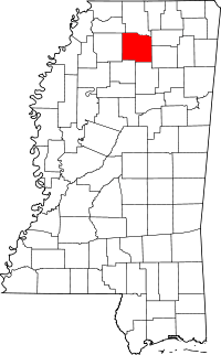 | |
| Town | ||
| CDP | ||
| Other unincorporated communities | ||
| Ghost town | ||
.svg.png)