1965 Palm Sunday tornado outbreak
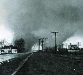 Picture of the "double tornado" that hit the Midway Trailer Park in Indiana, killing 14. | |
| Formed | 12:55, April 11, 1965 |
|---|---|
| Dissipated | 00:30, April 12, 1965 |
| Tornadoes confirmed | 47 |
| Max rating1 | F4 tornado |
| Damage | 5.5 billion (2007 dollars)[1] |
| Casualties | 271 total fatalities, 1,500 injuries |
| Areas affected | Indiana, Michigan, Ohio, Wisconsin, Iowa, Illinois |
| 1Most severe tornado damage; see Fujita scale | |
The second Palm Sunday tornado outbreak occurred on April 11–12, 1965, in the Midwest U.S. states of Indiana, Ohio, Michigan, Wisconsin, Illinois and Iowa, with 47 tornadoes (32 significant, 17 violent, 21 killers). It was the second-biggest outbreak on record at the time. In the Midwest, 271 people were killed and 1,500 injured (1,200 in Indiana). It was the deadliest tornado outbreak in Indiana history, with 137 people killed.[1] The outbreak also made that week in April 1965 the second-most-active week in history, with 51 significant and 21 violent tornadoes.
Meteorological synopsis
The tornadoes occurred in a swath 450 miles long (724 km) from Cedar County, Iowa, to Cuyahoga County, Ohio, and a swath 450 miles long (724 km) from Kent County, Michigan, to Montgomery County, Indiana. The outbreak lasted 11 hours and is among the most intense outbreaks, in terms of number, strength, width, path, and length of tornadoes, ever recorded, including four "double/twin funnel" tornadoes.
The outbreak was one of the deadliest, and most violent ever documented, with 17 confirmed violent tornadoes (F4-F5 intensity) all of which were rated F4, the second most amount of violent twisters in one outbreak behind the Super Outbreak of 1974.[2] It occurred on Palm Sunday, an important day to Protestants and Catholics, and many people were attending services at church, one possible reason why some warnings were not received. There had been a short winter that year, and as the day progressed, the temperature rose to 83 °F (28 °C) in some areas of the Midwestern United States.
Confirmed tornadoes
| F0 | F1 | F2 | F3 | F4 | F5 | Total |
|---|---|---|---|---|---|---|
| 0 | 15 | 10 | 5 | 17 | 0 | 47 |
April 11 event
| List of reported tornadoes - Sunday, April 11, 1965 | ||||||
|---|---|---|---|---|---|---|
| F# | Location | County | Time (UTC) | Path length | Damage | |
| Iowa | ||||||
| F4 | NE of Tipton | Cedar, Clinton, Jackson | 1855 | 91.5 miles (147.3 km) | 1 death - One person died one month later from their injuries. 25 farms were affected, one of which had every building leveled. Pieces of a farm house were carried for over a mile. | |
| F1 | SE of New Hampton | Chickasaw, Fayette, Allamakee | 1915 | 49.9 miles (80.3 km) | ||
| Wisconsin | ||||||
| F1 | SE of Monroe | Green, Rock, Dane | 2000 | 27.1 miles (43.6 km) | 50 homes and 65 businesses destroyed or damaged and 40 were injured. Over 400 cars were damaged or destroyed. | |
| F2 | S of Watertown | Jefferson | 2030 | 14.5 miles (23.3 km) | 3 deaths - Deaths were from occupants of a car that was thrown. 28 others were injured. Structures were destroyed on 20 farms. May have been an F3. | |
| F1 | S of Soldiers Grove | Crawford | 2045 | 13.3 miles (21.4 km) | One barn was destroyed. | |
| F1 | W of Lake Geneva | Walworth | 2150 | 1.9 miles (3.1 km) | Homes and structures were damaged near Williams Bay. | |
| F1 | NW of Elkhorn | Walworth | 2155 | 1 mile (1.6 km) | One barn was destroyed. | |
| F1 | W of Tomah | Monroe | 2214 | 2 miles (3.2 km) | Several farm buildings were destroyed. | |
| Illinois | ||||||
| F4 | Crystal Lake | McHenry, Lake | 2120 | 9.1 miles (14.6 km) | 6 deaths - Destroyed large sections of the town including a shopping mall. 45 homes were destroyed and 110 were damaged in a single subdivision. A few of the homes were completely swept away. Damage estimates were at about $1.5 million. | |
| F2 | N of Gurnee | Lake | 2150 | 4.5 miles (7.2 km) | Several homes were damaged and two planes flipped at Waukegan Memorial Airport. Falling trees damaged some homes and two others lost their roofs. | |
| F1 | Geneva | Kane | 2200 | 0.3 miles (0.5 km) | About a dozen homes were heavily damaged | |
| F1 | Zion | Lake | 2204 | 0.5 miles (0.8 km) | ||
| Indiana | ||||||
| F3 | NE of Knox to S of South Bend | Starke, Marshall, St. Joseph, Elkhart | 2245 | 35.6 miles (57.3 km) | 10 deaths - 30 cottages were destroyed and 70 others were damaged along Koontz Lake. 26 homes, one church and one high school were also destroyed. There were 82 people injured. Severe damage took place near La Paz and in the town of Wyatt. May have been an F4.[2] | |
| F3 | S of Crown Point to SE of Laporte | Porter, Laporte | 2310 | 33.1 miles (53.3 km) | Several homes and barns were destroyed and 4 people were injured. | |
| F4 | W of Wakarusa to NW of Middlebury | Elkhart | 2315 | 21.2 miles (34.1 km) | 14 deaths - Tornado first touched down and caused severe damage in the Wakarusa area. Destroyed the Midway Trailer Park in Dunlap and numerous other homes in the Middlebury area. Some homes were completely swept away. Was photographed as a double funnel. An airplane wing was found 35 miles away in Centerville, Michigan. 1st of 2 tornadoes hitting the town of Dunlap and the Elkhart region. | |
| F4 | NE of Goshen to W of Orland | Elkhart, LaGrange | 2340 | 21.6 miles (34.8 km) | 5 deaths - Dozens of homes were demolished in the Rainbow Lake and Shore areas, several of which were completely swept away. Some sources list 17 fatalities. | |
| F4 | Manitou Beach-Devils Lake, Michigan (1st tornado) | Steuben, Branch (MI), Hillsdale (MI), Lenawee (MI), Monroe (MI), Washtenaw (MI) | 0000 | 90.3 miles (145.3 km) | 23 deaths - Starting just south of the Indiana-Michigan state line, the massive tornado caused extensive damage to the Manitou Beach region and areas southwest of Detroit.[3] Many structures were destroyed, including a row of homes that were completely swept away and thrown into Coldwater Lake. First of two violent tornadoes to affect the same large portion of Lower Michigan. Damage from the two tornadoes was difficult to separate. | |
| F4 | SE of Lafayette to W of Russiaville | Tippecanoe, Clinton | 0007 | 21.8 miles (35.1 km) | Several homes and other buildings were destroyed or damaged. Homes were completely leveled in Mulberry and Moran. | |
| F4 | SE of South Bend to NE of Shipshewana | St. Joseph, Elkhart, LaGrange | 0010 | 37 miles (59.5 km) | 36 deaths - Second violent tornado struck the Dunlap/Elkhart region in just over an hour. The Sunnyside subdivision was completely destroyed, with many homes swept away. The Kingston Heights subdivision was also devastated. 6 of the victims were killed when the tornado demolished a truck stop. Affected rescue efforts after the first tornado. Also was witnessed as a double funnel tornado. Was initially rated an F5 but downgraded to an F4.[4] | |
| F4 | Russiaville to SE of Marion and Greentown | Clinton, Howard, Grant | 0020 | 48 miles (77.2 km) | 25 deaths - Large sections of Russiaville, Greentown, southern Kokomo and Alto were destroyed. 90% of the structures in Russiaville were damaged or destroyed. The tornado was up to a mile wide when it struck Alto and Kokomo, where hundreds of homes were destroyed. Many homes were destroyed and swept away as the tornado struck Greentown, and multiple fatalities occurred in vehicles in that area. A hospital had its roof torn off south of Marion, and a shopping center was destroyed. Several homes were destroyed in Marion as well. Over 800 people were injured. | |
| F4 | SE of Crawfordsville to Arcadia | Montgomery, Boone, Hamilton | 0050 | 45.7 miles (73.5 km) | 28 deaths - 80 homes were destroyed and over 100 people were injured between Crawfordsville and Arcadia. Some of the most severe damage occurred near the towns of Lebanon and Sheridan. Tornado was up to a mile wide and threw cars over 100 yards. May have been an F5.[4] | |
| F4 | W of Montpellier to N of Spencerville, OH | Blackford, Wells, Adams, Mercer (OH), Van Wert (OH) | 0110 | 52.5 miles (84.5 km) | 4 deaths - F4 damage was observed in Keystone in Wells County. Severe damage also occurred in the Berne area, where a bowling alley, a lumber yard, and a grocery store were destroyed. Tornado crossed into Ohio where it destroyed five homes and damaged five others.[2] | |
| Michigan | ||||||
| F4 | N of Grand Rapids | Ottawa, Kent | 2254 | 20.6 miles (33.2 km) | 5 deaths - 34 homes were destroyed and nearly 200 others damaged near the northern suburbs of Comstock Park and Alpine. Nearly 150 were injured and damage amounts were estimated at almost $15 million. | |
| F1 | N of Middleville | Allegan, Barry | 0005 | 19.5 miles (31.4 km) | 1 death - A trailer and 5 homes were destroyed while 25 others were damaged. | |
| F3 | NE of Kalamazoo | Kalamazoo | 0030 | 14.2 miles (22.9 km) | 4 homes were destroyed and 22 others damaged. 17 people were injured. | |
| F3 | Hastings | Barry | 0040 | 14.1 miles (22.7 km) | 15 homes were damaged and barns and garages were leveled. | |
| F4 | Manitou Beach-Devils Lake, Michigan (2nd tornado) | Branch, Hillsdale, Lenawee, Monroe, Washtenaw | 0040 | 80.5 miles (129.6 km) | 21 deaths - Second tornado to hit the same areas 30 minutes after being affected by the first tornado. Tornado leveled what was left standing from the first tornado. Total damage estimates from the two tornadoes were $32 million. Over 550 homes, 2 churches, a dance hall, and 100 cottages were destroyed in total. The two tornadoes also caused major damage in and around the towns of Onsted and Milan.[3] | |
| F4 | N of Lansing | Clinton, Shiawassee | 0115 | 21 miles (33.8 km) | 1 death - Several homes were severely damaged or destroyed, one of which was swept away. | |
| F2 | W of Ithaca | Montcalm, Gratiot | 0125 | 15.1 miles (24.3 km) | Several farm buildings and livestocks were destroyed. One home was nearly leveled. | |
| F2 | Alma (1st tornado) | Gratiot | 0130 | 0.1 miles (0.16 km) | One of three tornadoes to strike the area where it caused damage to several buildings including the library, which had its roof torn off. A telephone repair facility was destroyed as well. | |
| F2 | Alma (2nd tornado) | Gratiot | 0130 | 0.5 miles (0.8 km) | ||
| F2 | E of Alma | Gratiot | 0130 | 1 mile (1.6 km) | ||
| F2 | SE of Bay City | Bay | 0150 | 9.9 miles (15.9 km) | Tornado tore the roof off homes and an auto dealership. Trailers and barns were destroyed as well. | |
| F2 | SW of Unionville | Tuscola | 0200 | 9 miles (14.5 km) | Damage to a firehall and lumberyard. Barns were also destroyed. | |
| Ohio | ||||||
| F4 | Northern Toledo | Lucas, Monroe (MI) | 0230 | 5.6 miles (9.0 km) | 18 deaths - Numerous homes in the northern suburbs of Toledo were completely destroyed, several of which were completely swept away. 5 people were killed when the tornado picked up a bus and slammed it upside down onto the pavement. Boats and cars were thrown onto and into buildings. A paint factory and department store were destroyed as well. Two people were killed on the Lost Peninsula in Michigan. There were reports of twin tornadoes during the event. Damage amounts were estimated at $25 million. | |
| F4 | N of Lima | Allen, Hancock | 0230 | 32.5 miles (52.3 km) | 13 deaths - Numerous homes and farms were destroyed along the track, some of which were completely obliterated.[2] | |
| F4 | N of Sidney | Shelby | 0300 | 18.4 miles (29.6 km) | 3 deaths - Affected Anna, Swanders and Maplewood where 25 homes were destroyed and 20 others heavily damaged. Several train cars were derailed, and an automobile was carried for 200 yards. | |
| F3 | SE of Tiffin | Seneca | 0315 | 15 miles (24.1 km) | 4 deaths - Struck Rockaway, where 4 homes were leveled and three others were damaged. | |
| F4 | S of Oberlin to Strongsville | Lorain, Cuyahoga | 0405 | 22 miles (35.4 km) | 18 deaths - Extensive damage to Pittsfield and Strongsville. Pittsfield was nearly entirely destroyed and 6 homes were completely swept away there. Vehicles were thrown hundreds of feet and mangled. The tornado then struck Grafton at F2 strength, damaging homes and a car dealership[5] before re-intensifying and striking the north side of Strongsville. In Strongsville 18 homes were leveled, some of which were cleanly swept from their foundations. 50 others were badly damaged in town. Damage amounts were estimated at $5 million. Was listed as an F5 according to meteorologist Thomas Grazulis. Also witnessed as a double tornado. | |
| F1 | S of Eaton | Preble | 0415 | 0.1 miles (0.16 km) | ||
| F1 | Brunswick | Medina | 0430 | 8.2 miles (13.2 km) | One home was destroyed and several others were damaged in Brunswick. | |
| F2 | N of Delaware | Union, Delaware, Morrow | 0430 | 22.2 miles (35.7 km) | 4 deaths - Tornado struck the towns of Radnor and Westfield. 4 were killed in Radnor and 22 were injured in Westfield. 25 homes were destroyed. | |
| F1 | S of Cedarville | Greene | 0450 | 0.1 miles (0.16 km) | ||
| F1 | Ashville to Somerset | Pickaway, Fairfield, Perry | 0530 | 38.4 miles (61.8 km) | Several farm buildings were destroyed along the path. A dozen trailers were destroyed at a sales lot in Dumontville. | |
| Sources:
Tornado History Project Tornado Data for April 11, 1965, Tornado History Project Tornado Data for April 12, 1965, NWS Detroit Storm Data | ||||||
April 12 event
| List of reported tornadoes - Monday, April 12, 1965 | ||||||
|---|---|---|---|---|---|---|
| | | | | | ||
| Georgia | ||||||
| F1 | SW of Grassdale | Bartow | 0950 | 2 miles (3.2 km) | ||
| West Virginia | ||||||
| F2 | N of Princeton | Mercer | 1130 | 0.1 miles (0.16 km) | ||
| Sources: | ||||||
Outbreak description
At around 12:55 p.m., the first tornado touched down in Cedar County, Iowa.[6] It was rated F4 on the Fujita scale and spawned from a thunderstorm cell first detected near Tipton in Cedar County, Iowa, around 12:45 p.m. by radio news reporter Martin Jensen. He was stationed at WMT in Cedar Rapids located some 50 miles (80 km) northwest of Tipton. The station was equipped with a Collins Radio aviation radar mounted on the roof of the station building and used to support severe weather reports on local and regional newscasts. After detecting the severe thunderstorm, the reporter called National Weather Service offices in Waterloo (which had no radar) and Des Moines to alert them about the storm. The phone call became the first hard evidence for the Weather Service regarding the growing threat of severe storms which spawned dozens of tornadoes over the next 12 hours.
Illinois
A tornado touched down at Crystal Lake, Illinois, where it destroyed several subdivisions and a golf course. It grazed a junior high school before destroying several homes in a small community (Colby's Home Estates). There, 110 homes were damaged and 45 others were destroyed, as well as a shopping center: Crystal Lake Plaza on Route 14. Five people were killed, with three of the fatalities occurring when a truck was thrown into an exposed basement, where several people were taking shelter.[2] The tornado then crested a hill and destroyed the small community of Island Lake, killing one person before ascending back into the clouds at 3:42 p.m. This was one of the many F4 tornadoes that occurred during this outbreak.
Indiana

The tornado count increased as the day progressed. Several touched down in Indiana, many of them fatal. Individual supercells spawned as many as 5 violent tornadoes as they tracked west to east. The first touched down at around 5:30 p.m. in Koontz Lake, Indiana. This F3 tornado killed 10 people and injured 180. The tornado moved northeast past La Paz and Lakeville where it damaged LaVille Jr.-Sr. High School, which was under construction. The tornado continued into Wyatt and destroyed twenty homes.[2]
Another tornado formed near the St. Joseph County-Elkhart County border. It tracked east-northeasterly, striking Wakarusa, Indiana, where it killed a child. The tornado moved toward Dunlap, and the Midway trailer park.[3] Elkhart Truth reporter Paul Huffman captured a series of photographs as the twin-funneled, F4 tornado obliterated the trailer park, just south of Dunlap. This initial tornado killed 14 people. One half-hour later, a second F4 tornado directly struck Dunlap to the north and devastated the Sunnyside Housing addition and the unoccupied Sunnyside Mennonite Church.[3] The death toll from the Sunnyside Housing Addition was 28 people, with another six killed at a truck stop at the intersection of Highways 15 and 20. The Palm Sunday Tornado Memorial Park now exists near this location, at the corner of County Road 45 and Cole Street in Dunlap. Most of the 36 people killed in the tornado had no warning because the high winds from the first tornado had knocked out telephone and power grids. For the first time in the U.S. Weather Bureau's history, all nine counties in the northern Indiana office's jurisdiction were under a tornado warning.[7] This is called a "blanket tornado warning."[7] Both tornadoes were officially rated as F4 according to the National Weather Service records. However, both the Midway and Dunlap tornadoes were previously rated F5.[7]
Ninety miles (145 km) to the south, at just past 7:30 p.m., another massive tornado slammed into the town of Russiaville, Indiana. Most of the town was destroyed, leaving several dead. The storm churned into nearby Alto, obliterating it completely, before striking the southern edge of the larger city of Kokomo. As the tornado continued east, it killed ten more people in Greentown, Indiana, most of whom had been riding in automobiles that were hurled across the landscape. Multiple homes were completely destroyed there as well. More destruction ensued in Marion, Indiana before the tornado lifted.[2] In Berne, Indiana, another tornado cut a path through the northern part of the small city damaging homes and businesses including a bowling alley, grocery store and lumber yard before the storm crossed into Ohio and destroyed additional homes before dissipating.[2]
Michigan and Ohio
| State | Total | County | County total |
|---|---|---|---|
| Iowa | 1 | Cedar | 1 |
| Illinois | 6 | McHenry | 6 |
| Indiana | 138 | Adams | 1 |
| Boone | 20 | ||
| Elkhart | 62 | ||
| Grant | 8 | ||
| Hamilton | 6 | ||
| Howard | 17 | ||
| Lagrange | 10 | ||
| Marshall | 3 | ||
| Montgomery | 2 | ||
| St. Joseph | 3 | ||
| Starke | 4 | ||
| Wells | 2 | ||
| Michigan | 53 | Allegan | 1 |
| Branch | 18 | ||
| Clinton | 1 | ||
| Hillsdale | 6 | ||
| Kent | 5 | ||
| Lenawee | 9 | ||
| Monroe | 13 | ||
| Ohio | 60 | Allen | 11 |
| Cuyahoga | 1 | ||
| Delaware | 4 | ||
| Hancock | 2 | ||
| Lorain | 17 | ||
| Lucas | 16 | ||
| Mercer | 2 | ||
| Seneca | 4 | ||
| Shelby | 3 | ||
| Wisconsin | 3 | Jefferson | 3 |
| Totals | 261 | ||
| All deaths were tornado-related | |||
With the telephone lines down, emergency services in Elkhart County, Indiana, could not warn Michigan residents that the tornadoes were headed their way. The radar operator at the U.S. Weather Bureau, at Detroit Metro Airport, observed that the thunderstorms over northern Indiana and western Lower Michigan, were moving east-northeast at 70 mph (112 km/h). In Michigan, tornadoes hit as far north as Kent County, Michigan, just north of Grand Rapids. Of the southernmost counties of Michigan, all but three (Berrien, Cass, and St. Joseph counties) were hit. Two F4 tornadoes struck Hillsdale County (along with several other counties)[2] and destroyed about 200 cottages along Baw Beese Lake. Many people escaped harm as they were in church instead of out at the lake. Later, the Manitou Beach-Devils Lake area in Lenawee was hit by the two tornadoes in a span of a little more than 30 minutes, causing numerous fatalities (including a family of six). The local dance pavilion on Devils Lake was demolished, having recently been rebuilt after a fire on Labor Day in 1963. One of the tornadoes damaged parts of Onsted; in the nearby village of Tipton, which suffered a direct hit, 94% of the town's buildings were damaged or destroyed.
The pair of F4 tornadoes also struck Milan (at that point, still a village), south of Ann Arbor, straddling the county line in southeastern Washtenaw County (York Township) and northwestern Monroe County (Milan Township).[3] One tornado destroyed the Wolverine Plastics building on the Monroe County side of town (then, the top employer in the village), completely removing the roof in the process. That or the other tornado then struck and seriously damaged the Milan Junior High School and the adjacent, disused (since 1958) senior high school, at Hurd and North streets, on the Washtenaw County side of Milan. Milan became a city in 1967; opened a new Middle School in 1969, which replaced the old Junior High School; and eventually demolished the 1900 building that housed the former junior and senior high schools.
Tornadoes continued from Indiana into Ohio where additional fatalities occurred across the state border. A double tornado was sighted near Toledo, Ohio, which devastated northern parts of the city with at least F4 tornado damage.[2] Five people were killed when the tornado flipped over a bus on the Detroit-Toledo Expressway (today's Interstate 75). Other violent tornadoes occurred near the Indiana/Ohio border.
At around 11 p.m., a tornado touched down in Lorain County, Ohio, and struck Pittsfield, Ohio, killing seven and destroying most structures. The same tornado caused severe damage to homes in Grafton. When the storm neared the Cleveland, Ohio area, it diverged into two paths about 1⁄2 mile (0.8 km) apart. Several witnesses also saw two funnels merging into one similar to the first Dunlap tornado.[7] Large trees laying 50 feet (15 m) apart were felled lying in different directions. The storm also displayed at least F4 damage in Strongsville, where homes simply disappeared. This tornado killed 18 people and was also previously rated as an F5 before being lowered to an F4 by NWS officials. Some tornado experts such as Thomas P. Grazulis, still consider it to be an F5.
The last killer tornado occurred at 12:30 a.m. on April 12. It moved along a 22 miles (35 km) path north of Columbus, Ohio, causing F2 damage and killing four people.[2]
Aftermath
The U.S. Weather Bureau investigated the large number of deaths. Although Radar stations were few and far between in 1965, the severe nature of this storm was identified with adequate time to disseminate warnings. But the warning system failed as the public never received them. Additionally, the public did not know the difference between a Forecast and an Alert. Thus the Tornado watch and Tornado warning programs were implemented. Pivotal to those clarifications was a meeting in the WMT-TV studio in Cedar Rapids, Iowa. Officials of the severe storms forecast center in Kansas City met with WMT meteorologist Conrad Johnson and News Director Grant Price. Their discussion led to establishment of the official "watch" and "warning" procedures in use since 1965.
As technology has advanced since 1965; warnings can be spread via cable and satellite television, PCs and the Internet, solid-state electronics, cell phones, and NOAA Weather Radio.
Suction vortices
Dr. Ted Fujita discovered suction vortices during the Palm Sunday tornado outbreak. It had previously been thought the reason why tornadoes could hit one house and leave another across the street completely unscathed was because the tornado would "jump" from one house to another. However, Dr. Fujita discovered that the actual reason is most destruction is caused by suction vortices: small, intense mini-tornadoes within the main tornado.
Casualties
In the Midwest, 271 people were killed and 1,500 injured (1,200 in Indiana). It was the deadliest tornado outbreak in Indiana history with 138 people killed.
See also
- List of North American tornadoes and tornado outbreaks
- 1920 Palm Sunday tornado outbreak
- 1932 Deep South tornado outbreak
- 1974 Super Outbreak
- 1994 Palm Sunday tornado outbreak
References
- 1 2 Heidorn, Keith C. (April 1, 2007). "1965 Palm Sunday Tornado Outbreak Part I: The Beginning". The Weather Doctor. Archived from the original on 2007-12-01. Retrieved 10 December 2012.
- 1 2 3 4 5 6 7 8 9 10 11 (Grazulis 1993)
- 1 2 3 4 5 "The Palm Sunday Outbreak". Tornado History Project. Retrieved 2013-09-09.
- 1 2 http://www1.ncdc.noaa.gov/pub/data/techrpts/tr9902/tr9902.pdf
- ↑ "Remembering the Pittsfield Tornado | Neil Zurcher's One Tank Trips". Archived from the original on 2013-07-02. Retrieved 2013-06-29.
- ↑ Sun News
- 1 2 3 4 Blake Naftel. "April 11, 1965: The Palm Sunday Outbreak". Western Michigan University. Archived from the original on 2005-04-08. Retrieved 10 December 2012.
- Grazulis, Thomas P. (1993). Significant Tornadoes 1680-1991, A Chronology and Analysis of Events (hardcover). The Tornado Project of Environmental Films. ISBN 1-879362-00-7.
- King, Marshall (April 10, 2005). "One for the books". The Elkhart Truth, The Elkhart Truth Online Edition
- NCDC 22508, National Climatic Data Center. Accessed 2009-03-31.
- Deedler, William King (March 2005). "Palm Sunday Tornado Outbreak: April 11, 1965". The National Weather Service, Detroit/White Lake National Weather Service Office
External links
- 1965 Palm Sunday Tornado Outbreak (Keith C. Heidorn)
- The Palm Sunday Tornado Outbreak Story (NWS Detroit, MI)
- Palm Sunday Tornado Outbreak (Blake Naftel - Internet Archive)
- April 11, 1965, Palm Sunday Tornado Outbreak (NWS Indianapolis, IN)
- The Palm Sunday Story April 11, 1965 (NWS Northern Indiana)
- Full map of 1965 Palm Sunday tornado outbreak The Tornado History Project
- April 11, 1965 — Palm Sunday Outbreak (Shawn Schuman)
Further reading
- Palm Sunday Tornadoes of April 11, 1965, by Tetsuya T. Fujita and Dorothy L. Bradbury, with C. F. Van Thullenar. Chicago Satellite & Mesometeorology Research Project, University of Chicago, 1970. There is no ISBN available; Library of Congress Control Number: 70017916.
- The Night of the Wicked Winds: the 1965 Palm Sunday tornadoes in Ohio, by Roger Pickenpaugh. Baltimore, MD: Gateway Press, 2003. ISBN 0-9709059-3-9 (paperback).
- Winds of fury, circles of grace: life after the Palm Sunday tornadoes, by Dale Clem. Nashville: Abingdon Press, 1997. ISBN 0-687-01795-5 (alk. paper)
- The Mighty Whirlwind, by David Wagler. Aylmer, Ontario: Pathway Publishing Corp., 1966. There is no ISBN available; Library of Congress Control Number: 67112646.
- The Palm Sunday Tornado, by Timothy E. Bontrager, 2005. A novel by an author whose grandparents died in the tornado. For details see www.timothybontrager.com.
- Fujita, Tetsuya T., et al. (1970). "Palm Sunday Tornadoes of April 11, 1965", web: AllP-DOI. Monthly Weather Review, 98 (1), pp. 29–69.
- Night of the Wind: The Palm Sunday Tornado of April 11, 1965, by Dan Cherry. Adrian, Michigan: Lenawee County Historical Society, 2002. A collection of interviews and eyewitness accounts from the Devils Lake area, located in northwest Lenawee County. There is no ISBN available; Library of Congress Control Number not available.