Bartow County, Georgia
| Bartow County, Georgia | |
|---|---|
| County | |
| Bartow County | |
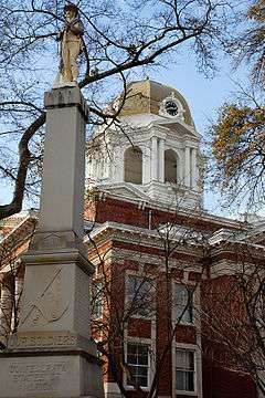 The Bartow County Courthouse, built in 1902. | |
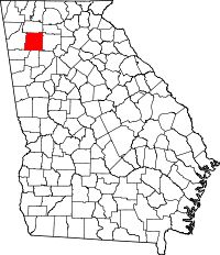 Location in the U.S. state of Georgia | |
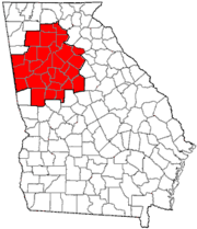
 Georgia's location in the U.S. | |
| Founded | December 3, 1832 |
| Named for | Francis S. Bartow |
| Seat | Cartersville |
| Largest city | Cartersville |
| Area | |
| • Total | 470 sq mi (1,217 km2) |
| • Land | 460 sq mi (1,191 km2) |
| • Water | 11 sq mi (28 km2), 2.2% |
| Population | |
| • (2010) | 100,157 |
| • Density | 218/sq mi (84/km²) |
| Congressional district | 11th |
| Time zone | Eastern: UTC-5/-4 |
| Website |
www |
Bartow County is a county located in the northwestern part of the U.S. state of Georgia. As of the 2010 census, the population was 100,157.[1] The county seat is Cartersville.[2]
Traditionally considered part of northwest Georgia, Bartow County is now included in the Atlanta metropolitan area, mainly in the southeastern part near Cartersville, which has become an exurb more than 40 miles or nearly 70 kilometers from downtown Atlanta on I-75. It has a sole commissioner government, and is the largest county by population of the few remaining in Georgia with a sole commissioner.
History
Bartow County was created from the Cherokee lands of the Cherokee County territory on December 3, 1832, and named Cass County, after General Lewis Cass (1782–1866) Secretary of War under President Andrew Jackson, Minister to France and Secretary of State under President James Buchanan,[3] who was instrumental in the removal of Native Americans from the area, until the county was renamed on December 6, 1861 in honor of Francis S. Bartow due to Cass' alleged opposition to slavery,[4] even though Bartow never stepped foot in the county that bears his name, having lived some 200 miles away near Savannah virtually all his life. Cass supported the doctrine of popular sovereignty, which essentially is states' rights, the right of each state to determine its own laws independently of the Federal government; ironcially the platform of conservative Southerners then who removed his name and to this very day. The first county seat was at Cassville, but after the burning of the county courthouse and the Sherman Occupation the seat moved to Cartersville, where it remains.
The county was profoundly affected by the Civil War, setting it back economically for many decades. May 18 and 19, 1864, General George Henry Thomas led the Army of the Cumberland after General William J. Hardee's Corps of the Army of Tennessee, and General James B. McPherson led his Federal Army of the Tennessee flanking Hardee's army to the west. This huge army was disruptive and sought food. Elements were out of control and sacked homes depleting meager supplies.[5]
Property destruction and the deaths of one-third of the county's soldiers during the war caused financial and social calamity for many.
Slaves gained their freedom, and briefly exercised political franchise through the Republican Party. In 1870, about 1 black family in 12 owned real estate. Over a third of the blacks lived in white-headed households, working as domestic servants and laborers. The great majority of freedpeople were day laborers or farm laborers, while a sizable minority occupied skilled positions such as blacksmiths, wheelwrights, and iron workers.[6]
By the late 1870s, hardship was experienced by everyone. Blacks had been relegated to second-class citizenship by Jim Crow laws.
Geography
According to the U.S. Census Bureau, the county has a total area of 470 square miles (1,217 km2), of which 460 square miles (1,191 km2) is land and 11 square miles (28 km2) or 2.2% is water.[7]
The bulk of Bartow County is located in the Etowah River sub-basin of the ACT River Basin (Alabama-Coosa-Tallapoosa River Basin). The northeastern portion of the county around Rydal is located in the Coosawattee River sub-basin of the same ACT River Basin, while an even smaller northwestern section around Adairsville is located in the Oostanaula River sub-basin of the larger ACT River Basin.[8]
The Etowah is mostly part of Lake Allatoona in southeast Bartow and southwest Cherokee counties, with the Allatoona Dam near Cartersville also impounding Allatoona Creek into northwest Cobb county. The peninsula between the two major arms of the lake is home to Red Top Mountain State Park, east-southeast of Cartersville and just southeast of the dam.
Adjacent counties
- Gordon County – north
- Pickens County – northeast
- Cherokee County – east
- Cobb County – southeast
- Paulding County – south
- Polk County – southwest
- Floyd County – west
Demographics
| Historical population | |||
|---|---|---|---|
| Census | Pop. | %± | |
| 1840 | 9,390 | — | |
| 1850 | 13,300 | 41.6% | |
| 1860 | 15,724 | 18.2% | |
| 1870 | 16,566 | 5.4% | |
| 1880 | 18,690 | 12.8% | |
| 1890 | 20,616 | 10.3% | |
| 1900 | 20,823 | 1.0% | |
| 1910 | 25,388 | 21.9% | |
| 1920 | 24,527 | −3.4% | |
| 1930 | 25,364 | 3.4% | |
| 1940 | 25,283 | −0.3% | |
| 1950 | 27,370 | 8.3% | |
| 1960 | 28,267 | 3.3% | |
| 1970 | 32,663 | 15.6% | |
| 1980 | 40,760 | 24.8% | |
| 1990 | 55,911 | 37.2% | |
| 2000 | 76,019 | 36.0% | |
| 2010 | 100,157 | 31.8% | |
| Est. 2015 | 102,747 | [9] | 2.6% |
| U.S. Decennial Census[10] 1790-1960[11] 1900-1990[12] 1990-2000[13] 2010-2013[1] | |||
2000 census
As of 2000, there are 76,019 people, 27,176 households, and 21,034 families residing in the county. The population density is 64/km2 (166/mi2). There are 28,751 housing units at an average density of 24 persons/km2 (63 persons/mi2). The racial makeup of the county is 87.79% White, 8.68% African American, 0.28% Native American, 0.51% Asian, 0.03% Pacific Islander, 1.62% from other races, and 1.10% from two or more races. 3.32% of the population are Hispanic or Latino of any race.
There are 27,176 households out of which 38.20% have children under the age of 18 living with them, 61.90% are married couples living together, 11.10% have a woman whose husband does not live with her, and 22.60% are non-families. 18.70% of all households are made up of individuals and 6.70% have someone living alone who is 65 years of age or older. The average household size is 2.76 and the average family size is 3.14.
In the county the population is spread out with 27.90% under the age of 18, 8.30% from 18 to 24, 33.00% from 25 to 44, 21.40% from 45 to 64, and 9.40% who are 65 years of age or older. The median age is 34 years. For every 100 females there are 97.70 males. For every 100 females age 18 and over, there are 94.90 males.
The median income for a household in the county is $43,660, and the median income for a family is $49,198. Males have a median income of $35,136 versus $24,906 for females. The per capita income for the county is $18,989. 8.60% of the population and 6.60% of families are below the poverty line. Out of the total people living in poverty, 9.60% are under the age of 18 and 12.20% are 65 or older.
2010 census
As of the 2010 United States Census, there were 100,157 people, 35,782 households, and 26,529 families residing in the county.[14] The population density was 217.9 inhabitants per square mile (84.1/km2). There were 39,823 housing units at an average density of 86.7 per square mile (33.5/km2).[15] The racial makeup of the county was 82.7% white, 10.2% black or African American, 0.7% Asian, 0.4% American Indian, 0.1% Pacific islander, 3.8% from other races, and 2.1% from two or more races. Those of Hispanic or Latino origin made up 7.7% of the population.[14] In terms of ancestry, 13.9% were American, 10.0% were Irish, 9.3% were English, and 7.8% were German.[16]
Of the 35,782 households, 39.8% had children under the age of 18 living with them, 54.8% were married couples living together, 13.5% had a female householder with no husband present, 25.9% were non-families, and 21.0% of all households were made up of individuals. The average household size was 2.77 and the average family size was 3.20. The median age was 36.2 years.[14]
The median income for a household in the county was $49,216 and the median income for a family was $56,281. Males had a median income of $42,835 versus $31,225 for females. The per capita income for the county was $22,241. About 10.8% of families and 14.0% of the population were below the poverty line, including 18.9% of those under age 18 and 12.1% of those age 65 or over.[17]
Education
Excel Christian Academy (Kindergarten - 12th Grade, SACS Accredited Academy)
The Trinity School (Kindergarten - 8th Grade, SACS Accredited School)
Politics
Bartow County has voted Republican since the 1960s. Mitt Romney carried the county in the 2012 presidential election with 75.1% of the vote. Barack Obama won the minority of votes in the county, at 23.5%, making Bartow County one of the least Democratic counties in Georgia.
Transportation
Major highways
Secondary highways
- Euharlee Road
- Old S.R. 293. Portion south of Emerson and east of U.S. 41 into Cobb County.
- Old Alabama Road. Future route of S.R. 113.
- Burnt Hickory Road
- Taylorsville-Macedonia Road
- Macedonia Road
- Halls Station Road
- Spring Place Road
- Cassville-White Road
- Glade Road
- Red Top Mountain Rd
- Peeples Valley Rd
- Cassville Rd (Old U.S. 41)
Museums
- Bartow History Museum[18] opened in 1987 and is located in the historic 1869 Courthouse in downtown Cartersville. Artifacts, photographs, documents and a variety of permanent exhibits focus on the settlement and development of Bartow County, Georgia, beginning with the early nineteenth century when the Cherokee inhabited the area. Early European settler life, the iron ore and bauxite industries, Civil War strife, post-war recovery, the Great Depression era, early textile industries and notable figures are depicted through interactive exhibits in the permanent gallery space. The museum offers a wide variety of education programs, and lectures.
- Booth Western Art Museum,[19] an Affiliate of the Smithsonian Institution, is a 120,000-square-foot (11,000 m2) museum located in Cartersville. Guests are invited to See America’s Story through contemporary Western artwork, Presidential portraits and letters, Civil War art, more than 200 Native American artifacts, and Sagebrush Ranch children’s gallery. Open since August 2003, Booth Museum is the second largest art museum in the state of Georgia, and houses the largest permanent exhibition space for Western art in the country.
- Tellus Science Museum,[20] an affiliate of the Smithsonian Institution, is a world-class 120,000-square-foot (11,000 m2) museum is located in Cartersville, just off I-75 at exit 293. The museum features four main galleries: The Weinman Mineral Gallery, The Fossil Gallery, Science in Motion and The Collins Family My Big Backyard. There is also a 120-seat digital planetarium and an observatory with a state-of-the-art 20-inch telescope located at Tellus.
- Euharlee History Museum,[21] is located adjacent to the Euharlee Covered Bridge in Euharlee, Georgia, about 9 miles west of downtown Cartersville. The museum opened in 1997 and is a cooperation between the Euharlee Historical Society and the City of Euharlee.
- Adairsville Rail Depot Age of Steam Museum,[22] is located in a restored 1847 railroad depot on the Historic Public Square, in Adairsville along with a locally operated Welcome Center. The Museum displays artifacts and pictures covering almost 150 years of life in the area, including the Civil War, the chenille boom, railroad history, early farming implements, and weapons.
Recreation
- Bartow County Georgia Hiking Trails[23]
- Etowah Indian Mounds
Communities
Cities
Unincorporated communities
- Atco
- Cassville
- Rowland Springs
- Stilesboro
- Rydal (south of Pine Log)
- Pine Log (north of Rydal)
- Folsom
- Center
- Funkhouser
- Allatoona (mostly lost to Lake Allatoona, but portion remains at Allatoona Pass)
Historical Communities[24]
| Allatoona | Aylmer | ATCO | Aubrey | Bartow |
| Best's | Birmingham | Bochee | Bolivar | Cass Line |
| Cass Station | Cassville (Manassas) | Cave | Cement | Center |
| Clifford | Connaseena | Corbin | Dewey | Etowah |
| Etowah Valley (see Rowland Springs) | Eves | Ferrobutte (see Rogers Station) | Five Forks | Flexatile (see Funkhouser) |
| Folsom | Ford | Grassdale | Gum Springs | Halls Station (see Linwood) |
| Iron Hill | Ironville | Junta | Ladds | Ligon |
| Linwood (see Hall's Station) | Little Prairie | Malbone | McCallie | McGinnis |
| Mountain House | Murchisons | Nalinza | Pine Log (see Rydal) | Rogers Station (aka Rogersville) |
| Rowland Springs (see Etowah Valley) | Ruby | Rydal (see Pine Log) | Sanfordsville | Sophia |
| Stamp Creek | Stilesboro | Sugar Hill | Woolley's | Wyvern |
See also
References
- 1 2 "State & County QuickFacts". United States Census Bureau. Retrieved June 18, 2014.
- ↑ "Find a County". National Association of Counties. Archived from the original on 2012-07-12. Retrieved 2011-06-07.
- ↑ ,
- ↑ "Bartow County". Calhoun Times. September 1, 2004. p. 13. Retrieved 23 April 2015.
- ↑ Howard, Frances Thomas (2007). In and Out of the Lines. Cartesville, Georgia: Etowah Valley Historical Society. pp. 9, overleaf.
- ↑ Keith S. Hébert, "The Bitter Trial of Defeat and Emancipation: Reconstruction in Bartow County, Georgia, 1865–1872," Georgia Historical Quarterly, Spring 2008, Vol. 92 Issue 1, pp 65–92
- ↑ "US Gazetteer files: 2010, 2000, and 1990". United States Census Bureau. 2011-02-12. Retrieved 2011-04-23.
- ↑ "Georgia Soil and Water Conservation Commission Interactive Mapping Experience". Georgia Soil and Water Conservation Commission. Retrieved 2015-11-19.
- ↑ "County Totals Dataset: Population, Population Change and Estimated Components of Population Change: April 1, 2010 to July 1, 2015". Retrieved July 2, 2016.
- ↑ "U.S. Decennial Census". United States Census Bureau. Archived from the original on May 11, 2015. Retrieved June 18, 2014.
- ↑ "Historical Census Browser". University of Virginia Library. Retrieved June 18, 2014.
- ↑ "Population of Counties by Decennial Census: 1900 to 1990". United States Census Bureau. Retrieved June 18, 2014.
- ↑ "Census 2000 PHC-T-4. Ranking Tables for Counties: 1990 and 2000" (PDF). United States Census Bureau. Retrieved June 18, 2014.
- 1 2 3 "DP-1 Profile of General Population and Housing Characteristics: 2010 Demographic Profile Data". United States Census Bureau. Retrieved 2015-12-27.
- ↑ "Population, Housing Units, Area, and Density: 2010 - County". United States Census Bureau. Retrieved 2015-12-27.
- ↑ "DP02 SELECTED SOCIAL CHARACTERISTICS IN THE UNITED STATES – 2006-2010 American Community Survey 5-Year Estimates". United States Census Bureau. Retrieved 2015-12-27.
- ↑ "DP03 SELECTED ECONOMIC CHARACTERISTICS – 2006-2010 American Community Survey 5-Year Estimates". United States Census Bureau. Retrieved 2015-12-27.
- ↑ Bartow History Museum
- ↑ Booth Western Art Museum
- ↑ Tellus Science Museum
- ↑ Euharlee History Museum Facebook page
- ↑ Adairsville Rail Depot Museum
- ↑ Bartow County Georgia Hiking Trails
- ↑ Place names supplied by Etowah Valley Historical Society -- EVHS
External links
- AnteBartow County Official Website
- Antebellum Iron Industry in North Georgia Centered in Bartow County
- Bartow Ancestors - People, Places & History of Bartow County
- Bartow County historical marker
 |
Gordon County | Pickens County | | |
| Floyd County | |
Cherokee County | ||
| ||||
| | ||||
| Polk County | Paulding County | Cobb County |
Municipalities and communities of Bartow County, Georgia, United States | ||
|---|---|---|
| Cities | | |
| Town | ||
| Unincorporated communities | ||
| Ghost town | ||
| Footnotes | ‡This populated place also has portions in an adjacent county or counties | |
|  | |||||||
|
| ||||||||
| ||||||||
Coordinates: 34°14′N 84°50′W / 34.24°N 84.84°W