Cedar County, Iowa
| Cedar County, Iowa | |
|---|---|
|
| |
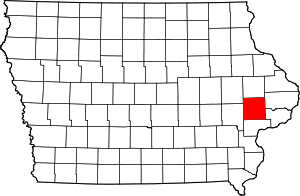 Location in the U.S. state of Iowa | |
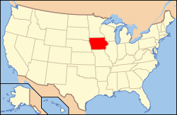 Iowa's location in the U.S. | |
| Founded | 1837 |
| Named for | Cedar River |
| Seat | Tipton |
| Largest city | Tipton |
| Area | |
| • Total | 582 sq mi (1,507 km2) |
| • Land | 579 sq mi (1,500 km2) |
| • Water | 2.5 sq mi (6 km2), 0.4% |
| Population | |
| • (2010) | 18,499 |
| • Density | 32/sq mi (12/km²) |
| Congressional district | 2nd |
| Time zone | Central: UTC-6/-5 |
| Website |
www |
Cedar County is a county located in the U.S. state of Iowa. As of the 2010 census, the population was 18,499.[1] Its county seat is Tipton.[2] The county is named for the Cedar River, which runs through the county.
Cedar County is located between the Cedar Rapids, Quad Cities and Iowa City metropolitan areas, areas also known as the "Tri-Metro" county. It is the only Iowa county which shares the name of a tree.
Cedar County was the focus of the Iowa Cow War of 1931.
History
Cedar County was formed on December 21, 1837, from sections of Dubuque County. It was named for the Cedar River.
In 1840, the City of Tipton, the current county seat, was established.
Before the American Civil War, the area around West Branch was an active focal point of the Underground Railroad, a network for the freeing of slaves from the southern states.
The former US President Herbert Hoover (1874-1964) was born in West Branch in Cedar County.[3]
The Cedar County Sheriff's House and Jail is believed to be the last jail and residence combination still in use when it closed in 2001.[4] It was listed on the National Register of Historic Places in 2003.
Geography
According to the U.S. Census Bureau, the county has a total area of 582 square miles (1,510 km2), of which 579 square miles (1,500 km2) is land and 2.5 square miles (6.5 km2) (0.4%) is water.[5] Rock Creek flows through Cedar County.
Major highways
Adjacent counties
- Jones County (north)
- Clinton County (northeast)
- Scott County (southeast)
- Muscatine County (south)
- Johnson County (west)
- Linn County (northwest)
National protected area
Demographics
| Historical population | |||
|---|---|---|---|
| Census | Pop. | %± | |
| 1850 | 3,941 | — | |
| 1860 | 12,949 | 228.6% | |
| 1870 | 19,731 | 52.4% | |
| 1880 | 18,936 | −4.0% | |
| 1890 | 18,253 | −3.6% | |
| 1900 | 19,371 | 6.1% | |
| 1910 | 17,765 | −8.3% | |
| 1920 | 17,560 | −1.2% | |
| 1930 | 16,760 | −4.6% | |
| 1940 | 16,884 | 0.7% | |
| 1950 | 16,910 | 0.2% | |
| 1960 | 17,791 | 5.2% | |
| 1970 | 17,655 | −0.8% | |
| 1980 | 18,635 | 5.6% | |
| 1990 | 17,444 | −6.4% | |
| 2000 | 18,187 | 4.3% | |
| 2010 | 18,499 | 1.7% | |
| Est. 2015 | 18,340 | [6] | −0.9% |
| U.S. Decennial Census[7] 1790-1960[8] 1900-1990[9] 1990-2000[10] 2010-2013[1] | |||
2010 census
The 2010 census recorded a population of 13,956 in the county, with a population density of 31.89/sq mi (12.31/km2). There were 8,064 housing units, of which 7,511 were occupied.[11]
2000 census
As of the census[12] of 2000, there were 18,187 people, 7,147 households, and 5,138 families residing in the county. The population density was 31 people per square mile (12/km²). There were 7,570 housing units at an average density of 13 per square mile (5/km²). The racial makeup of the county was 98.47% White, 0.19% Black or African American, 0.19% Native American, 0.30% Asian, 0.03% Pacific Islander, 0.26% from other races, and 0.57% from two or more races. 0.94% of the population were Hispanic or Latino of any race.
There were 7,147 households out of which 33.30% had children under the age of 18 living with them, 61.60% were married couples living together, 6.70% had a female householder with no husband present, and 28.10% were non-families. 23.70% of all households were made up of individuals and 11.90% had someone living alone who was 65 years of age or older. The average household size was 2.51 and the average family size was 2.96.
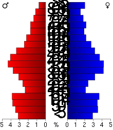
In the county the population was spread out with 25.30% under the age of 18, 6.90% from 18 to 24, 27.70% from 25 to 44, 23.80% from 45 to 64, and 16.20% who were 65 years of age or older. The median age was 39 years. For every 100 females there were 97.50 males. For every 100 females age 18 and over, there were 94.60 males.
The median income for a household in the county was $42,198, and the median income for a family was $48,850. Males had a median income of $32,008 versus $23,260 for females. The per capita income for the county was $19,200. About 4.00% of families and 5.50% of the population were below the poverty line, including 5.00% of those under age 18 and 7.70% of those age 65 or over.
Communities
Cities
Census-designated place
Unincorporated communities
- Buchanan
- Cedar Bluff
- Cedar Valley
- Centerdale
- Downey
- Lime City
- Plato
- Massillon
- Springdale
- Sunbury
- Wald
Townships
Cedar County is divided into seventeen townships:
Population ranking
The population ranking of the following table is based on the 2010 census of Cedar County.[13]
† county seat
| Rank | City/Town/etc. | Municipal type | Population (2010 Census)
|
|---|---|---|---|
| 1 | † Tipton | City | 3,221 |
| 2 | Wilton (mostly in Muscatine County) | City | 2,802 |
| 3 | West Branch (partially in Johnson County) | City | 2,322 |
| 4 | Durant (partially in Muscatine and Scott Counties) | City | 1,832 |
| 5 | Mechanicsville | City | 1,146 |
| 6 | Clarence | City | 974 |
| 7 | Lowden | City | 789 |
| 8 | Stanwood | City | 684 |
| 9 | Bennett | City | 405 |
| 10 | Rochester | CDP | 133 |
Notable people
- Herbert Hoover (1874–1964), the 31st President of the United States (1929–1933) and the first president born west of the Mississippi River (born in West Branch in 1874).
- John Brown (1800–1859), abolitionist, maintained his headquarters at William Maxson's house near the small community of Springdale in Cedar County while planning his Harpers Ferry raid; Edwin and Barclay Coppock of Springdale participated in the raid.
- Lawrie Tatum (1822–1900), an Indian Agent to the Kiowa and Comanche tribes and, beginning in 1884, guardian to future President Herbert Hoover.
See also
References
- 1 2 "State & County QuickFacts". United States Census Bureau. Retrieved July 14, 2014.
- ↑ "Find a County". National Association of Counties. Archived from the original on 2011-05-31. Retrieved 2011-06-07.
- ↑ Burner, David (1996). Herbert Hoover: A Public Life. Easton Press.
- ↑ Oltrogge, Sarah. "Properties Listed on National Register of Historic Places Earn Recognition". State Historical Society of Iowa. Retrieved 2012-05-29.
- ↑ "US Gazetteer files: 2010, 2000, and 1990". United States Census Bureau. 2011-02-12. Retrieved 2011-04-23.
- ↑ "County Totals Dataset: Population, Population Change and Estimated Components of Population Change: April 1, 2010 to July 1, 2015". Retrieved July 2, 2016.
- ↑ "U.S. Decennial Census". United States Census Bureau. Archived from the original on May 11, 2015. Retrieved July 14, 2014.
- ↑ "Historical Census Browser". University of Virginia Library. Retrieved July 14, 2014.
- ↑ "Population of Counties by Decennial Census: 1900 to 1990". United States Census Bureau. Retrieved July 14, 2014.
- ↑ "Census 2000 PHC-T-4. Ranking Tables for Counties: 1990 and 2000" (PDF). United States Census Bureau. Retrieved July 14, 2014.
- ↑ "Population and Housing Occupancy Status: 2010 - State -- County". United States Census Bureau American FactFinder. Retrieved March 8, 2011.
- ↑ "American FactFinder". United States Census Bureau. Archived from the original on 2013-09-11. Retrieved 2008-01-31.
- ↑ "Archived copy". Archived from the original on 2013-12-21. Retrieved 2013-02-10.
External links
| Wikimedia Commons has media related to Cedar County, Iowa. |
 |
Linn County | Jones County | Clinton County | |
| Johnson County | |
|||
| ||||
| | ||||
| Muscatine County | Scott County |
Municipalities and communities of Cedar County, Iowa, United States | ||
|---|---|---|
| Cities | ||
| Townships | ||
| CDP | ||
| Other unincorporated communities | ||
| Footnotes | ‡This populated place also has portions in an adjacent county or counties | |
Coordinates: 41°46′N 91°08′W / 41.767°N 91.133°W