Grafton, Ohio
| Grafton, Ohio | |
|---|---|
| Village | |
|
| |
 Location of Grafton, Ohio | |
 Location of Grafton in Lorain County | |
| Coordinates: 41°16′33″N 82°3′11″W / 41.27583°N 82.05306°WCoordinates: 41°16′33″N 82°3′11″W / 41.27583°N 82.05306°W | |
| Country | United States |
| State | Ohio |
| County | Lorain |
| Government | |
| • Mayor | David DiVencenzo |
| • Administrator | Joe Price |
| Area[1] | |
| • Total | 4.74 sq mi (12.28 km2) |
| • Land | 4.71 sq mi (12.20 km2) |
| • Water | 0.03 sq mi (0.08 km2) |
| Elevation[2] | 804 ft (245 m) |
| Population (2010)[3] | |
| • Total | 6,636 |
| • Estimate (2012[4]) | 5,931 |
| • Density | 1,408.9/sq mi (544.0/km2) |
| Time zone | Eastern (EST) (UTC-5) |
| • Summer (DST) | EDT (UTC-4) |
| ZIP code | 44044 |
| Area code(s) | 440 |
| FIPS code | 39-31150[5] |
| GNIS feature ID | 1064744[2] |
Grafton is a village in Lorain County, Ohio, United States, along the East Branch of the Black River. The population was 6,636 at the 2010 census. The Lorain Correctional Institution and several other prisons are located in and near Grafton.
History
Grafton was platted in 1846 when the railroad was extended to that point.[6] The village's name may be a transfer from Grafton, Massachusetts.[7]
Geography
Grafton is located at 41°16′33″N 82°3′11″W / 41.27583°N 82.05306°W (41.275919, -82.053154).[8]
According to the United States Census Bureau, the village has a total area of 4.74 square miles (12.28 km2), of which 4.71 square miles (12.20 km2) is land and 0.03 square miles (0.08 km2) is water.[1]
Demographics
| Historical population | |||
|---|---|---|---|
| Census | Pop. | %± | |
| 1890 | 600 | — | |
| 1900 | 1,098 | 83.0% | |
| 1910 | 955 | −13.0% | |
| 1920 | 900 | −5.8% | |
| 1930 | 935 | 3.9% | |
| 1940 | 971 | 3.9% | |
| 1950 | 1,194 | 23.0% | |
| 1960 | 1,683 | 41.0% | |
| 1970 | 1,771 | 5.2% | |
| 1980 | 2,231 | 26.0% | |
| 1990 | 3,344 | 49.9% | |
| 2000 | 2,302 | −31.2% | |
| 2010 | 6,636 | 188.3% | |
| Est. 2015 | 6,165 | [9] | −7.1% |
| Sources:[5][10][11][12][13][14] | |||
2010 census
As of the census[3] of 2010, there were 6,636 people, 965 households, and 726 families residing in the village. The population density was 1,408.9 inhabitants per square mile (544.0/km2). There were 1,008 housing units at an average density of 214.0 per square mile (82.6/km2). The racial makeup of the village was 65.0% White, 32.7% African American, 0.2% Native American, 0.3% Asian, 1.2% from other races, and 0.7% from two or more races. Hispanic or Latino of any race were 2.3% of the population.
There were 965 households of which 37.9% had children under the age of 18 living with them, 56.0% were married couples living together, 13.5% had a female householder with no husband present, 5.8% had a male householder with no wife present, and 24.8% were non-families. 20.1% of all households were made up of individuals and 7.4% had someone living alone who was 65 years of age or older. The average household size was 2.68 and the average family size was 3.07.
The median age in the village was 36.2 years. 10.4% of residents were under the age of 18; 13.7% were between the ages of 18 and 24; 43.9% were from 25 to 44; 26.3% were from 45 to 64; and 5.6% were 65 years of age or older. The gender makeup of the village was 79.7% male and 20.3% female.
2000 census
As of the census[5] of 2000, there were 2,302 people, 832 households, and 643 families residing in the village. The population density was 510.0 people per square mile (197.1/km²). There were 853 housing units at an average density of 189.0 per square mile (73.0/km²). The racial makeup of the village was 97.83% White, 0.52% African American, 0.35% Native American, 0.26% Asian, 0.22% from other races, and 0.83% from two or more races. Hispanic or Latino of any race were 0.74% of the population.
There were 832 households out of which 38.2% had children under the age of 18 living with them, 60.7% were married couples living together, 12.4% had a female householder with no husband present, and 22.6% were non-families. 19.4% of all households were made up of individuals and 8.7% had someone living alone who was 65 years of age or older. The average household size was 2.77 and the average family size was 3.17.
In the village the population was spread out with 28.2% under the age of 18, 8.1% from 18 to 24, 30.5% from 25 to 44, 23.2% from 45 to 64, and 10.0% who were 65 years of age or older. The median age was 35 years. For every 100 females there were 93.6 males. For every 100 females age 18 and over, there were 90.4 males.
The median income for a household in the village was $52,446, and the median income for a family was $60,139. Males had a median income of $40,833 versus $26,732 for females. The per capita income for the village was $19,584. About 0.7% of families and 2.4% of the population were below the poverty line, including 1.8% of those under age 18 and 4.0% of those age 65 or over.
Notable people
- Ed McKean, born in Grafton, major league baseball player[15]
- Ryan Feierabend - major league baseball
References
- 1 2 "US Gazetteer files 2010". United States Census Bureau. Retrieved 2013-01-06.
- 1 2 "US Board on Geographic Names". United States Geological Survey. 2007-10-25. Retrieved 2008-01-31.
- 1 2 "American FactFinder". United States Census Bureau. Retrieved 2013-01-06.
- ↑ "Population Estimates". United States Census Bureau. Retrieved 2013-06-17.
- 1 2 3 "American FactFinder". United States Census Bureau. Retrieved 2008-01-31.
- ↑ "Welcome Home To The Village of Grafton". Village of Grafton, OH. Retrieved 12 June 2016.
- ↑ Overman, William Daniel (1958). Ohio Town Names. Akron, OH: Atlantic Press. p. 53.
- ↑ "US Gazetteer files: 2010, 2000, and 1990". United States Census Bureau. 2011-02-12. Retrieved 2011-04-23.
- ↑ "Annual Estimates of the Resident Population for Incorporated Places: April 1, 2010 to July 1, 2015". Retrieved July 2, 2016.
- ↑ "Population: Ohio" (PDF). 1910 U.S. Census. U.S. Census Bureau. Retrieved 28 November 2013.
- ↑ "Population: Ohio" (PDF). 1930 US Census. U.S. Census Bureau. Retrieved 28 November 2013.
- ↑ "Number of Inhabitants: Ohio" (PDF). 18th Census of the United States. U.S. Census Bureau. Retrieved 22 November 2013.
- ↑ "Ohio: Population and Housing Unit Counts" (PDF). U.S. Census Bureau. Retrieved 22 November 2013.
- ↑ "Incorporated Places and Minor Civil Divisions Datasets: Subcounty Population Estimates: April 1, 2010 to July 1, 2012". U.S. Census Bureau. Retrieved 25 November 2013.
- ↑ Reichler, Joseph L., ed. (1979) [1969]. The Baseball Encyclopedia (4th ed.). New York: Macmillan Publishing. ISBN 0-02-578970-8.
Municipalities and communities of Lorain County, Ohio, United States | ||
|---|---|---|
| Cities | 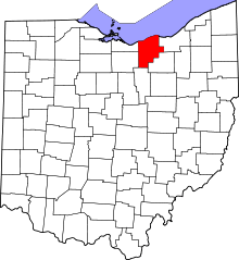 | |
| Villages | ||
| Townships | ||
| CDPs |
| |
| Unincorporated communities | ||
| Ghost town | ||
| Footnotes | ‡This populated place also has portions in an adjacent county or counties | |