Strongsville, Ohio
| Strongsville, Ohio | ||
|---|---|---|
| City | ||
|
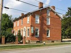
North side of Strongsville's Town Square | ||
| ||
| Nickname(s): Crossroads of the Nation | ||
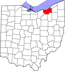
 Location in Cuyahoga County and the state of Ohio. | ||
.svg.png) Location of Ohio in the United States | ||
| Coordinates: 41°18′46″N 81°49′55″W / 41.31278°N 81.83194°WCoordinates: 41°18′46″N 81°49′55″W / 41.31278°N 81.83194°W | ||
| Country | United States | |
| State | Ohio | |
| County | Cuyahoga | |
| Township created | 1818 | |
| Village created | 1923 | |
| Incorporated | 1961 | |
| Government | ||
| • Type | Mayor-council | |
| • Mayor | Thomas Perciak (R)[1] | |
| Area[2] | ||
| • Total | 24.64 sq mi (63.82 km2) | |
| • Land | 24.63 sq mi (63.79 km2) | |
| • Water | 0.01 sq mi (0.03 km2) 0.04% | |
| Elevation | 932 ft (284.07 m) | |
| Population (2010)[3] | ||
| • Total | 44,750 | |
| • Estimate (2015[4]) | 44,668 | |
| • Density | 1,816.9/sq mi (701.5/km2) | |
| census | ||
| Time zone | EST (UTC-5) | |
| • Summer (DST) | EDT (UTC-4) | |
| Zip code | 44136, 44149 | |
| Area code(s) | 440 | |
| FIPS code | 39-75098 [5] | |
| GNIS feature ID | 1065396 [6] | |
| Website | strongsville.org | |

Strongsville is a city in Cuyahoga County, Ohio, United States, and a suburb of Cleveland. As of the 2010 census, the city population was 44,750. The city's nickname 'Crossroads of the Nation,' originated from the Baltimore and Ohio Railroad (B&O) intersecting with the Southwestern Electric Line that connected Cleveland and Wooster, Ohio. [7] As the railroad line ceased operation in 1931, the motto and city seal have been adapted to reflect the modern day intersection of Interstate 71 and the Ohio Turnpike. [8]
History
Strongsville officially became a township on February 25, 1818, a village in 1923, and was ultimately designated a city in 1961. Founded by settlers arriving in the newly purchased Connecticut Western Reserve, the city was named after John Stoughton Strong, the group's leader. Many of the main streets in the city are named after other principal figures and landowners from the city's history, e.g. Howe, Drake, Shurmer, Whitney.[9]
In the mid-19th century, the Pomeroy House, then called The Homestead, was a stop on the underground railroad. Alanson Pomeroy, the home owner and a prominent Strongsville resident, concealed runaway slaves on his property. From this residence in Strongsville, the runaway slaves were taken to boats on Rocky River for passage to Canada.[10]
In 1853, John D. Rockefeller's family moved to Strongsville. At the time, Rockfeller was only a child.[11]
On April 11, 1965, an F4 tornado hit Strongsville; see Palm Sunday tornado outbreak of 1965.
Geography
Strongsville is located at 41°18′46″N 81°49′55″W / 41.31278°N 81.83194°W (41.312752, -81.831976).[12]
According to the United States Census Bureau, the city has a total area of 24.64 square miles (63.82 km2), of which 24.63 square miles (63.79 km2) is land and 0.01 square miles (0.03 km2) is water.[2] The east branch of the Rocky River enters Strongsville from North Royalton and exits into Berea. Valley Parkway parallels the river's northwesterly course. This portion of the Cleveland Metroparks, named Mill Stream Run, includes Bonnie Park and Ranger Lake. Abutting the Rocky River, the recreation area offers visitors a pavilion, picnicking facilities, two small ponds, and several sport fields. Bonnie Park serves as a hub for hiking, bridle, and paved multi-purpose trails.
Demographics
| Historical population | |||
|---|---|---|---|
| Census | Pop. | %± | |
| 1930 | 1,349 | — | |
| 1940 | 2,216 | 64.3% | |
| 1950 | 3,504 | 58.1% | |
| 1960 | 8,504 | 142.7% | |
| 1970 | 15,182 | 78.5% | |
| 1980 | 28,577 | 88.2% | |
| 1990 | 35,308 | 23.6% | |
| 2000 | 43,858 | 24.2% | |
| 2010 | 44,750 | 2.0% | |
| Est. 2015 | 44,668 | [13] | −0.2% |
| Sources:[14][15][16][5][17] | |||
The median income for a household in the city was $68,660, and the median income for a family was $76,964 (these figures had risen to $79,715 and $90,870 respectively as of a 2007 estimate[18]). Males had a median income of $54,988 versus $33,129 for females. The per capita income for the city was $29,722. About 1.3% of families and 2.2% of the population were below the poverty line, including 1.7% of those under age 18 and 3.7% of those age 65 or over.
Of the city's population over the age of 25, 41.6% held a bachelor's degree or higher.[19]
2010 census
As of the census[3] of 2010, there were 44,750 people, 17,659 households, and 12,563 families residing in the city. The population density was 1,816.9 inhabitants per square mile (701.5/km2). There were 18,476 housing units at an average density of 750.1 per square mile (289.6/km2). The racial makeup of the city was 92.0% White, 1.9% African American, 0.1% Native American, 4.1% Asian, 0.4% from other races, and 1.4% from two or more races. Hispanic or Latino of any race were 2.0% of the population.
There were 17,659 households of which 31.5% had children under the age of 18 living with them, 60.5% were married couples living together, 7.4% had a female householder with no husband present, 3.2% had a male householder with no wife present, and 28.9% were non-families. 24.9% of all households were made up of individuals and 10.9% had someone living alone who was 65 years of age or older. The average household size was 2.52 and the average family size was 3.04.
The median age in the city was 44.2 years. 23.3% of residents were under the age of 18; 6.4% were between the ages of 18 and 24; 21.6% were from 25 to 44; 32.5% were from 45 to 64; and 16.1% were 65 years of age or older. The gender makeup of the city was 48.6% male and 51.4% female.
2000 census
As of the census[5] of 2000, there were 43,858 people, 16,209 households, and 12,383 families residing in the city. The population density was 1,779.6 people per square mile (687.2/km²). There were 16,863 housing units at an average density of 684.2 per square mile (264.2/km²). The racial makeup of the city was 94.18% White, 1.26% African American, 0.05% Native American, 3.21% Asian, 0.01% Pacific Islander, 0.28% from other races, and 1.03% from two or more races. Hispanic or Latino of any race were 1.27% of the population.
There were 16,209 households out of which 35.9% had children under the age of 18 living with them, 67.5% were married couples living together, 6.4% had a female householder with no husband present, and 23.6% were non-families. 19.9% of all households were made up of individuals and 7.0% had someone living alone who was 65 years of age or older. The average household size was 2.69 and the average family size was 3.13.
In the city the population was spread out with 26.3% under the age of 18, 6.2% from 18 to 24, 28.5% from 25 to 44, 27.6% from 45 to 64, and 11.4% who were 65 years of age or older. The median age was 39 years. For every 100 females there were 95.3 males. For every 100 females age 18 and over, there were 92.3 males.
Government
The current mayor, Thomas Perciak, was elected in November 2003 following the death of longtime mayor Walter F. Ehrnfelt on May 25, 2003.
Education
A staff of over 250 teachers at Strongsville High School serves well over 2,750 students in grades 9 through 12. Center and Albion middle schools (serving 7th and 8th graders) are about 75 and 40 years old, respectively. The city's seven elementary schools serve pre-kindergarten through 6th grade: Chapman, Drake, Kinsner, Muraski, Surrarrer, and Whitney. With Strongsville's younger student population on the decline, and seven elementary school, Allen and Zellers, recently closed their doors. A private Catholic school, St. Joseph and John's, serves children through the 8th grade. In 2012, citizens approved a bond issue for $81 million. The bond money was used to build a new middle school, combining Center and Albion middle schools, renovations to the high school, technology upgrades to the elementary schools, and renovations to the preschool. The new middle school was built just in time for the 2016-2017 school year.[20]
| Address | School mascot | Grades | |
|---|---|---|---|
| Strongsville High School | 20025 Lunn Road | Mustangs | 9th - 12th Grade |
| Strongsville Middle School | 13200 Pearl Rd | Mustangs | 6th-8th Grade |
| Chapman Elementary | 13883 Drake Road | Chargers | K-5th Grade |
| Drake Elementary | 20566 Albion Road | Bees | K-5th Grade |
| Kinsner Elementary | 19091 Waterford Parkway | Cobras | K-5th Grade |
| Muraski Elementary | 20270 Royalton Road | Wildcats | K-5th Grade |
| Surrarrer Elementary | 9306 Priem Road | Roadrunners | K-5th Grade |
| Whitney Elementary | 13548 Whitney Road | Bears | K-5th Grade |
Points of interest
- Mill Stream Run Reservation - The east branch of the Rocky River runs alongside this branch of the Cleveland Metroparks
- Strongsville Business & Technology Park - The largest industrial park in Northeast Ohio[21]
- Strongsville Commons and Clock Tower
- Walter F. Ehrnfelt Covered Bridge[22]
- Strongsville Historical Society
- Gardenview Horticultural Park
- Southpark Mall
- The Pomeroy House- A former stop on the Underground Railroad
- Strongsville Water Tower - Painted by Ziggy creator Tom Wilson
- Preserve of Strongsville - Strongsville's only national preserve
Notable people
- Zebedee Coltrin (1804–1887) Mormon pioneer, authority in the Church of Jesus Christ of Latter Day Saints
- Tom Dimitroff, Sr. (1935-1996) gridiron football player and coach
- Bruce Drennan (1950) sportscaster
- Walter F. Ehrnfelt (1932-2003) politician
- Asmahan Farhat (1990) swimmer
- Jenny Fish (1949) Olympic speed skater
- Nate Freese American football player
- Jackie Gayda (1981) professional wrestler
- Olga D. González-Sanabria scientist, inventor
- Michael Green (soccer) (1989) American soccer player
- Joe Haden American football player
- Paul Hoernemann (1916-1965) college football coach
- Tim Kamczyc (1990) basketball player
- Reggie Lee (actor) (1974) actor
- Fred McLeod (sportscaster) (1952) sportscaster
- Dayton Miller (1866–1941) physicist, astronomer, acoustician
- Lorin Morgan-Richards (1975) publisher, author (Beebetown, Ohio)
- Tom Patton politician
- Kyle Prandi (1979) Olympic diver
- Mike Pruitt American football player
- John D. Rockefeller (1839-1937) businessman, philanthropist
- William Rockefeller (1841–1922) businessman, financier, co-founder of Standard Oil
- George Myron Sabin (1833-1890) federal judge
- Isaac Sowells (1982) American football player
- Herb Stein (1898-1980) American football player
- Gary Suhadolnik politician
- Daniel Martin Varisco (1951) anthropologist, historian
- Kyle Veris (1983) American soccer player
- Matt Warburton television writer
- Aaron White (basketball) (1992) college basketball player
- D. J. Woods (1989) AFL football player
References
- ↑ Exner, Rich (16 November 2013). "Democrats outnumber Republicans as mayors in Cuyahoga County, 39-14". Cleveland.com. Retrieved 30 January 2016.
- 1 2 "US Gazetteer files 2010". United States Census Bureau. Retrieved 2013-01-06.
- 1 2 "American FactFinder". United States Census Bureau. Retrieved 2013-01-06.
- ↑ "Population Estimates". United States Census Bureau. Retrieved 2013-06-17.
- 1 2 3 "American FactFinder". United States Census Bureau. Retrieved 2008-01-31.
- ↑ "US Board on Geographic Names". United States Geological Survey. 2007-10-25. Retrieved 2008-01-31.
- ↑ "Strongsville: A Strong community evolves at the 'Crossroads' (PHOTOS)". Retrieved 1 September 2016.
- ↑ "City of Strongsville Government - About - Facebook". Retrieved 1 September 2016.
- ↑ "Atlas of Cuyahoga County, Ohio". Philadelphia, Pennsylvania: G. M. Hopkins Company. 1914. pp. 50 (on page 41). Retrieved 18 November 2013.
- ↑ "Ohio History Central http://www.ohiohistorycentral.org/entry.php?rec=3452
- ↑ "WGBH American Experience . The Rockefellers - PBS". Retrieved 1 September 2016.
- ↑ "US Gazetteer files: 2010, 2000, and 1990". United States Census Bureau. 2011-02-12. Retrieved 2011-04-23.
- ↑ "Annual Estimates of the Resident Population for Incorporated Places: April 1, 2010 to July 1, 2015". Retrieved July 2, 2016.
- ↑ "Population: Ohio" (PDF). 1930 US Census. U.S. Census Bureau. Retrieved 28 November 2013.
- ↑ "Number of Inhabitants: Ohio" (PDF). 18th Census of the United States. U.S. Census Bureau. Retrieved 22 November 2013.
- ↑ "Ohio: Population and Housing Unit Counts" (PDF). U.S. Census Bureau. Retrieved 22 November 2013.
- ↑ "Incorporated Places and Minor Civil Divisions Datasets: Subcounty Population Estimates: April 1, 2010 to July 1, 2012". U.S. Census Bureau. Retrieved 25 November 2013.
- ↑ Strongville, OH. United States Census Bureau.
- ↑ "Population estimates, July 1, 2015, (V2015)". Retrieved 1 September 2016.
- ↑ "Strongsville school board OKs $81M bond issue". Retrieved 1 September 2016.
- ↑ "Crain's releases list of Northeast Ohio's Largest Industrial Parks". 12 September 2011. Retrieved 1 September 2016.
- ↑ http://www.bridges-covered.com/ohio_ne.html
External links
| Wikimedia Commons has media related to Strongsville, Ohio. |
 |
Berea, Middleburg Heights | | ||
| Columbia Township | |
North Royalton | ||
| ||||
| | ||||
| Brunswick, Brunswick Hills Township | Hinckley |
Municipalities and communities of Cuyahoga County, Ohio, United States | ||
|---|---|---|
| Cities |
|  |
| Villages | ||
| Townships | ||
| Footnotes | ‡This populated place also has portions in an adjacent county or counties | |