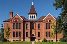
North Mankato, Minnesota
| North Mankato | |
|---|---|
| City | |
 Location of the city of North Mankato within Nicollet and Blue Earth Counties in the state of Minnesota | |
| Coordinates: 44°10′12.04″N 94°00′49.61″W / 44.1700111°N 94.0137806°WCoordinates: 44°10′12.04″N 94°00′49.61″W / 44.1700111°N 94.0137806°W | |
| Country | United States |
| State | Minnesota |
| Counties | Nicollet, Blue Earth |
| Government | |
| • Type | Mayor – Council |
| • Mayor | Mark Dehen |
| Area[1] | |
| • City | 5.99 sq mi (15.51 km2) |
| • Land | 5.87 sq mi (15.20 km2) |
| • Water | 0.12 sq mi (0.31 km2) |
| Elevation | 781 ft (238 m) |
| Population (2010)[2] | |
| • City | 13,394 |
| • Estimate (2015)[3] | 13,529 |
| • Density | 2,281.8/sq mi (881.0/km2) |
| • Metro | 99,134 (US: 355th) |
| Time zone | CST (UTC-6) |
| • Summer (DST) | CDT (UTC-5) |
| ZIP code | 56003 |
| Area code(s) | 507 |
| FIPS code | 27-47068 |
| GNIS feature ID | 0648669[4] |
| Website | northmankato.com |
North Mankato is a city in Nicollet and Blue Earth counties in the State of Minnesota. The population was 13,394 at the 2010 census.[5]
While most of the city is in Nicollet County, it extends into Blue Earth County a small amount as well. It is neighbored to the south across the Minnesota River by Mankato.[6] The two cities have a combined population of over 54,000. North Mankato is the smaller of the two principal cities of the Mankato-North Mankato Metropolitan Statistical Area, a metropolitan area that covers Blue Earth and Nicollet counties.
North Mankato was incorporated as a village in 1898.
U.S. Highways 14 and 169 and Minnesota State Highway 60 are three of the main routes in the city.
Geography
According to the United States Census Bureau, the city has a total area of 5.99 square miles (15.51 km2), of which 5.87 square miles (15.20 km2) is land and 0.12 square miles (0.31 km2) is water.[1]
Demographics
| Historical population | |||
|---|---|---|---|
| Census | Pop. | %± | |
| 1900 | 939 | — | |
| 1910 | 1,279 | 36.2% | |
| 1920 | 1,840 | 43.9% | |
| 1930 | 2,822 | 53.4% | |
| 1940 | 3,517 | 24.6% | |
| 1950 | 4,788 | 36.1% | |
| 1960 | 5,927 | 23.8% | |
| 1970 | 7,347 | 24.0% | |
| 1980 | 9,145 | 24.5% | |
| 1990 | 10,164 | 11.1% | |
| 2000 | 11,798 | 16.1% | |
| 2010 | 13,394 | 13.5% | |
| Est. 2015 | 13,529 | [7] | 1.0% |
| U.S. Decennial Census[8] 2015 Estimate[3] | |||
2010 census
As of the census[2] of 2010, there were 13,394 people, 5,580 households, and 3,553 families residing in the city. The population density was 2,281.8 inhabitants per square mile (881.0/km2). There were 5,864 housing units at an average density of 999.0 per square mile (385.7/km2). The racial makeup of the city was 93.9% White, 2.1% African American, 0.2% Native American, 1.7% Asian, 0.8% from other races, and 1.3% from two or more races. Hispanic or Latino of any race were 3.0% of the population.
There were 5,580 households of which 31.2% had children under the age of 18 living with them, 50.0% were married couples living together, 9.8% had a female householder with no husband present, 3.9% had a male householder with no wife present, and 36.3% were non-families. 27.6% of all households were made up of individuals and 9.2% had someone living alone who was 65 years of age or older. The average household size was 2.39 and the average family size was 2.92.
The median age in the city was 35.5 years. 23.7% of residents were under the age of 18; 10.1% were between the ages of 18 and 24; 27.8% were from 25 to 44; 26.3% were from 45 to 64; and 11.9% were 65 years of age or older. The gender makeup of the city was 49.3% male and 50.7% female.
2000 census
As of the census of 2000, there were 11,798 people, 4,744 households, and 3,178 families residing in the city. The population density was 2,502.5 people per square mile (967.1/km²). There were 5,046 housing units at an average density of 1,070.3 per square mile (413.6/km²). The racial makeup of the city was 96.47% White, 0.65% African American, 0.24% Native American, 1.38% Asian, 0.03% Pacific Islander, 0.44% from other races, and 0.79% from two or more races. Hispanic or Latino of any race were 1.59% of the population.
There were 4,744 households out of which 35.7% had children under the age of 18 living with them, 55.0% were married couples living together, 9.0% had a female householder with no husband present, and 33.0% were non-families. 24.7% of all households were made up of individuals and 7.3% had someone living alone who was 65 years of age or older. The average household size was 2.48 and the average family size was 2.99.
In the city the population was spread out with 26.3% under the age of 18, 10.9% from 18 to 24, 30.6% from 25 to 44, 22.5% from 45 to 64, and 9.6% who were 65 years of age or older. The median age was 33 years. For every 100 females there were 96.1 males. For every 100 females age 18 and over, there were 93.1 males.
The median income for a household in the city was $48,816, and the median income for a family was $59,265. Males had a median income of $38,720 versus $25,713 for females. The per capita income for the city was $23,916. About 5.3% of families and 7.0% of the population were below the poverty line, including 7.8% of those under age 18 and 7.2% of those age 65 or over.
Education
- Hoover Elementary School
- Monroe Elementary School
- Garfield 6th Grade Elementary School
- Dakota Meadows Middle School
- South Central College
Corporations
References
- 1 2 "US Gazetteer files 2010". United States Census Bureau. Retrieved 2012-11-13.
- 1 2 "American FactFinder". United States Census Bureau. Retrieved 2012-11-13.
- 1 2 "Population Estimates". United States Census Bureau. Retrieved June 17, 2016.
- ↑ "US Board on Geographic Names". United States Geological Survey. 2007-10-25. Retrieved 2008-01-31.
- ↑ "2010 Census Redistricting Data (Public Law 94-171) Summary File". American FactFinder. United States Census Bureau. Retrieved 27 April 2011.
- ↑ Upham, Warren (1920). Minnesota Geographic Names: Their Origin and Historic Significance. Minnesota Historical Society. p. 373.
- ↑ "Annual Estimates of the Resident Population for Incorporated Places: April 1, 2010 to July 1, 2015". Retrieved July 2, 2016.
- ↑ United States Census Bureau. "Census of Population and Housing". Retrieved September 12, 2013.
External links
Municipalities and communities of Blue Earth County, Minnesota, United States | ||
|---|---|---|
| Cities | 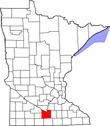 | |
| Townships | ||
| CDP | ||
| Unincorporated communities | ||
| Footnotes | ‡This populated place also has portions in an adjacent county or counties | |
Municipalities and communities of Nicollet County, Minnesota, United States | ||
|---|---|---|
| Cities | 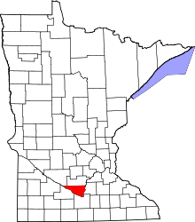 | |
| Townships | ||
| Unincorporated communities | ||
| Ghost town | ||
| Footnotes | ‡This populated place also has portions in an adjacent county or counties | |
| Core Cities | 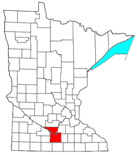 | ||||||
|---|---|---|---|---|---|---|---|
| Incorporated Places |
| ||||||
| Counties | |||||||
† indicates a county seat. ‡ indicates that it is partially in the metropolitan area. | |||||||