Otter Tail County, Minnesota
| Otter Tail County, Minnesota | |
|---|---|
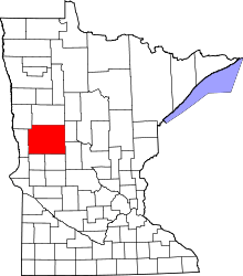 Location in the U.S. state of Minnesota | |
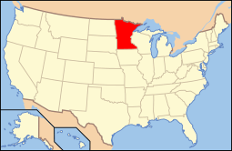 Minnesota's location in the U.S. | |
| Founded |
March 18, 1858 (created) 1868 (organized)[1] |
| Named for | Otter Tail Lake and Otter Tail River |
| Seat | Fergus Falls |
| Largest city | Fergus Falls |
| Area | |
| • Total | 2,225 sq mi (5,763 km2) |
| • Land | 1,972 sq mi (5,107 km2) |
| • Water | 252 sq mi (653 km2), 11% |
| Population (est.) | |
| • (2015) | 57,716 |
| • Density | 29/sq mi (11/km²) |
| Congressional district | 7th |
| Time zone | Central: UTC-6/-5 |
| Website |
www |
Otter Tail County is a county located in the U.S. state of Minnesota. As of the 2010 census, the population was 57,303.[2] Its county seat is Fergus Falls.[3] The county was formed in 1858 and organized in 1868.
Otter Tail County comprises the Fergus Falls, MN Micropolitan Statistical Area.
History
Native Americans used the survey area for hunting and fishing and had permanent dwelling sites. Two Native American tribes were in constant conflict. The Dakota (Sioux) were being pushed from their home area by the Ojibwa (Chippewa) during the late 18th century and early 19th century. Burial mounds and artifacts can still be found. Some of the oldest remains of Native Americans were found near Pelican Rapids, Minnesota. The remains, nicknamed Minnesota Girl, were dated at about 11,000 B.C. (Otter Tail County Historical Museum).
The first white men to enter the county were French and British fur traders. Efforts were made to set up trading posts on the Leaf Lakes and Otter Tail Lake. In the late 19th century, most of the towns were built along the railroad lines. Lumber and agriculture were the major industries in the county at that time. The pine and hardwood forests, transportation system, and markets were instrumental in the development of Fergus Falls into a lumber center.


In 1870, the population of the county was about 2,000. At that time the principal languages spoken in the county were Norwegian, Swedish, German, and English. Otter Tail County was established in March 1858 by a legislative act. It was organized in 1868. The original county seat was Ottertail City.
The people of Fergus Falls organized a new county named Holcomb. In 1872, a legislative act abolished Holcomb County, added additional townships to the west, and established Fergus Falls as the county seat of Otter Tail County. There are 62 townships in the county. The county is named for Otter Tail Lake and the Otter Tail River.[5]
Geography
According to the U.S. Census Bureau, the county has a total area of 2,225 square miles (5,760 km2), of which 1,972 square miles (5,110 km2) are land and 252 square miles (650 km2) (11%) are covered by water.[6] Otter Tail is one of 17 Minnesota savanna region counties with more savanna soils than either forest or prairie soils. According to the official web site, Otter Tail County contains over 1000 lakes and two Minnesota state parks, Maplewood State Park and Glendalough State Park. The highest point in Otter Tail County is Inspiration Peak in the Leaf Mountains, at 1750 feet above sea level.
Adjacent counties
- Becker County (north)
- Todd County (southeast)
- Douglas County (south)
- Grant County (southwest)
- Wilkin County (west)
- Clay County (northwest)
Transportation
Major highways
 Interstate 94
 U.S. Highway 10
 U.S. Highway 52
 U.S. Highway 59
 Minnesota State Highway 29
 Minnesota State Highway 34
 Minnesota State Highway 78
 Minnesota State Highway 106
 Minnesota State Highway 108
 Minnesota State Highway 210
 Minnesota State Highway 228
 Minnesota State Highway 235
 Minnesota State Highway 297
Airports
The following public-use airports are located in Otter Tail County:
- Fergus Falls Municipal Airport (FFM) in Fergus Falls
- Henning Municipal Airport (05Y) in Henning
- New York Mills Municipal Airport (25Y) in New York Mills
- Pelican Rapids Municipal Airport (47Y) in Pelican Rapids
- Perham Municipal Airport (16D) in Perham
- Wadena Municipal Airport (ADC) in Wadena
Demographics
| Historical population | |||
|---|---|---|---|
| Census | Pop. | %± | |
| 1860 | 240 | — | |
| 1870 | 1,968 | 720.0% | |
| 1880 | 18,675 | 848.9% | |
| 1890 | 34,232 | 83.3% | |
| 1900 | 45,375 | 32.6% | |
| 1910 | 46,036 | 1.5% | |
| 1920 | 50,818 | 10.4% | |
| 1930 | 51,006 | 0.4% | |
| 1940 | 53,192 | 4.3% | |
| 1950 | 51,320 | −3.5% | |
| 1960 | 48,960 | −4.6% | |
| 1970 | 46,097 | −5.8% | |
| 1980 | 51,937 | 12.7% | |
| 1990 | 50,714 | −2.4% | |
| 2000 | 57,159 | 12.7% | |
| 2010 | 57,303 | 0.3% | |
| Est. 2015 | 57,716 | [7] | 0.7% |
| U.S. Decennial Census[8] 1790-1960[9] 1900-1990[10] 1990-2000[11] 2010-2015[2] | |||

As of the census of 2000, there were 57,159 people, 22,671 households, and 15,779 families residing in the county. The population density was 29 people per square mile (11/km²). There were 33,862 housing units at an average density of 17 per square mile (7/km²). The racial makeup of the county was 97.11% White, 0.29% African American, 0.51% Native American, 0.44% Asian, 0.05% Pacific Islander, 0.84% from other races, and 0.78% from two or more races. Hispanic or Latino of any race were 1.67% of the population. 35.5% were of German and 31.2% Norwegian ancestry.
There were 22,671 households out of which 30.3% had children under the age of 18 living with them, 60.1% were married couples living together, 6.1% had a female householder with no husband present, and 30.4% were non-families. 26.6% of all households were made up of individuals and 13.30% had someone living alone who was 65 years of age or older. The average household size was 2.46 and the average family size was 2.98.
In the county the population was spread out with 24.9% under the age of 18, 7.2% from 18 to 24, 24.2% from 25 to 44, 24.7% from 45 to 64, and 19.0% who were 65 years of age or older. The median age was 41 years. For every 100 females there were 100.4 males. For every 100 females age 18 and over, there were 97.8 males.
The median income for a household in the county was $35,395, and the median income for a family was $42,740. Males had a median income of $30,151 versus $20,930 for females. The per capita income for the county was $18,014. About 6.7% of families and 10.1% of the population were below the poverty line, including 12.1% of those under age 18 and 11.1% of those age 65 or over.
Politics
| Year | Democratic | Republican |
|---|---|---|
| 2016 | 29% 9,339 | 64% 20,939 |
| 2012 | 38% 12,165 | 59% 18,860 |
| 2008 | 42% 13,856 | 55% 18,077 |
| 2004 | 37% 12,038 | 61% 19,734 |
| 2000 | 35% 9,176 | 59% 16,963 |
| 1996 | 40% 10,519 | 45% 11,808 |
| 1992 | 34% 9,844 | 41% 11,074 |
| 1988 | 42% 10,373 | 57% 14,015 |
| 1984 | 38% 9714 | 61% 15,664 |
| 1980 | 34% 9,108 | 57% 15,091 |
| 1976 | 48% 11,881 | 49% 12,113 |
| 1972 | 36% 7881 | 62% 13,519 |
| 1968 | 35% 7400 | 60% 12,483 |
| 1964 | 48% 9997 | 51% 10,542 |
| 1960 | 36% 8054 | 59% 16,080 |
In the U.S. presidential elections, Otter Tail County has mainly been a Republican county.
During the time period of the Great Depression, however, there was actually a communist faction within the county. The areas where the movement was centered in the county are quite desolate today, however, during mid-1932, the worst possible time for farmers, there were over 900 members involved with one of the state's communist organizations.[12] “The members of the communist party were very active in the New York Mills area of Newton, Leaf Lake, Blowers, Deer Creek and Paddock Townships. They held meetings, recruited members, placed candidates on local and state tickets, and distributed propaganda. They held dances in Heinola, Menahga, and Sebeka where the Soviet hammer and sickle was proudly displayed and ran a summer camp on East Leaf Lake.”[12]
By the time Franklin D. Roosevelt implemented some of the New Deal programs in the county, most of the communist movement began to lose steam. In addition, the Winter War in Europe between Finland and the U.S.S.R. soured the taste of communism to many Finnish immigrants (the Fins were a major denomination among the communists at the time). Carl Peltoniemi, a former supporter of the organization, said, “The communist movement within the Finnish community basically ended at the start of the Winter War in 1939-1940.”
Ever since the United States presidential election of 1936, Otter Tail County has voted Republican for every Presidential election. In the U.S. Presidential Election of 2008, 55% of the voters voted for John McCain while 42% voted for Barack Obama.
In the Minnesota House of Representatives, Otter Tail County is divided into two districts. District 8A and District 8B. Both are represented by Republicans Bud Nornes (8A) and Mary Franson (8B). Districts 8A and 8B make up the Minnesota State Senate district 8, which is represented by Republican State Senator Bill Ingebrigtsen.
Communities

Cities
- Battle Lake
- Bluffton
- Clitherall
- Dalton
- Deer Creek
- Dent
- Elizabeth
- Erhard
- Fergus Falls (county seat)
- Henning
- New York Mills
- Ottertail
- Parkers Prairie
- Pelican Rapids
- Perham
- Richville
- Rothsay (partly in Wilkin County)
- Underwood
- Urbank
- Vergas
- Vining
- Wadena (partly in Wadena County)
Townships
- Aastad Township
- Amor Township
- Aurdal Township
- Blowers Township
- Bluffton Township
- Buse Township
- Butler Township
- Candor Township
- Carlisle Township
- Clitherall Township
- Compton Township
- Corliss Township
- Dane Prairie Township
- Dead Lake Township
- Deer Creek Township
- Dora Township
- Dunn Township
- Eagle Lake Township
- Eastern Township
- Edna Township
- Effington Township
- Elizabeth Township
- Elmo Township
- Erhards Grove Township
- Everts Township
- Fergus Falls Township
- Folden Township
- Friberg Township
- Girard Township
- Gorman Township
- Henning Township
- Hobart Township
- Homestead Township
- Inman Township
- Leaf Lake Township
- Leaf Mountain Township
- Lida Township
- Maine Township
- Maplewood Township
- Newton Township
- Nidaros Township
- Norwegian Grove Township
- Oak Valley Township
- Orwell Township
- Oscar Township
- Otter Tail Township
- Otto Township
- Paddock Township
- Parkers Prairie Township
- Pelican Township
- Perham Township
- Pine Lake Township
- Rush Lake Township
- Scambler Township
- St. Olaf Township
- Star Lake Township
- Sverdrup Township
- Tordenskjold Township
- Trondhjem Township
- Tumuli Township
- Western Township
- Woodside Township
Unincorporated communities
See also
References
- ↑ "Minnesota Place Names". Minnesota Historical Society. Retrieved March 18, 2014.
- 1 2 "State & County QuickFacts". United States Census Bureau. Retrieved September 1, 2013.
- ↑ "Find a County". National Association of Counties. Retrieved 2011-06-07.
- ↑ Nelson, Steven (2011). Savanna Soils of Minnesota. Minnesota: Self. pp. 53 - 56. ISBN 978-0-615-50320-2.
- ↑ Otter Tail County Website http://www.co.otter-tail.mn.us/gis/soilsurvey03history.php
- ↑ "2010 Census Gazetteer Files". United States Census Bureau. August 22, 2012. Retrieved October 24, 2014.
- ↑ "County Totals Dataset: Population, Population Change and Estimated Components of Population Change: April 1, 2010 to July 1, 2015". Retrieved July 2, 2016.
- ↑ "U.S. Decennial Census". United States Census Bureau. Retrieved October 24, 2014.
- ↑ "Historical Census Browser". University of Virginia Library. Retrieved October 24, 2014.
- ↑ "Population of Counties by Decennial Census: 1900 to 1990". United States Census Bureau. Retrieved October 24, 2014.
- ↑ "Census 2000 PHC-T-4. Ranking Tables for Counties: 1990 and 2000" (PDF). United States Census Bureau. Retrieved October 24, 2014.
- 1 2 Tweton, Jerome (1988). The New Deal at the Grass Roots: Programs for the People in Otter Tail County, Minnesota. St. Paul: Minnesota Historical Society Press. pp. 29–31.
External links
| Wikimedia Commons has media related to Otter Tail County, Minnesota. |
- Otter Tail Country Tourism Association
- Otter Tail County government’s website
- Otter Tail County Historical Society
 |
Clay County | Becker County | Wadena County | |
| Wilkin County | |
|||
| ||||
| | ||||
| Grant County | Douglas County | Todd County |
Municipalities and communities of Otter Tail County, Minnesota, United States | ||
|---|---|---|
| Cities | | |
| Townships |
| |
| Unincorporated communities | ||
| Indian reservation | ||
| Ghost towns | ||
| Footnotes | ‡This populated place also has portions in an adjacent county or counties | |
Coordinates: 46°25′N 95°43′W / 46.41°N 95.71°W